All Activity
- Past hour
-

2025-2026 ENSO
40/70 Benchmark replied to 40/70 Benchmark's topic in Weather Forecasting and Discussion
I just gave a reason why it didn't snow despite a +PNA and -WPO....how am I placing too much stock in the teleconnections??? You are the one that just said it didn't snow despite a -WPO period last season.... I would argue that the subtropical ridge won't remain so robust should the WPO flip negative....we argree the west Pacific warmth is largely responsible for that ridge, which is a synonymous with a +WPO. -

July 2025 Obs/Disco ... possible historic month for heat
weatherwiz replied to Typhoon Tip's topic in New England
It’s been a wild year and expensive year. It happened almost exactly a year ago. He was in the hospital for a week and before he came home we had to drive an hour each day to learn how to express his bladder. We really struggled with it so we had to hire someone to come over the first week he came home to help us. The first two months my girlfriend and I alternated sleeping in the living room with him since he can’t get into the bed anymore. He’s come along way, but unfortunately won’t ever get 100% but we do what we can to make him happy -
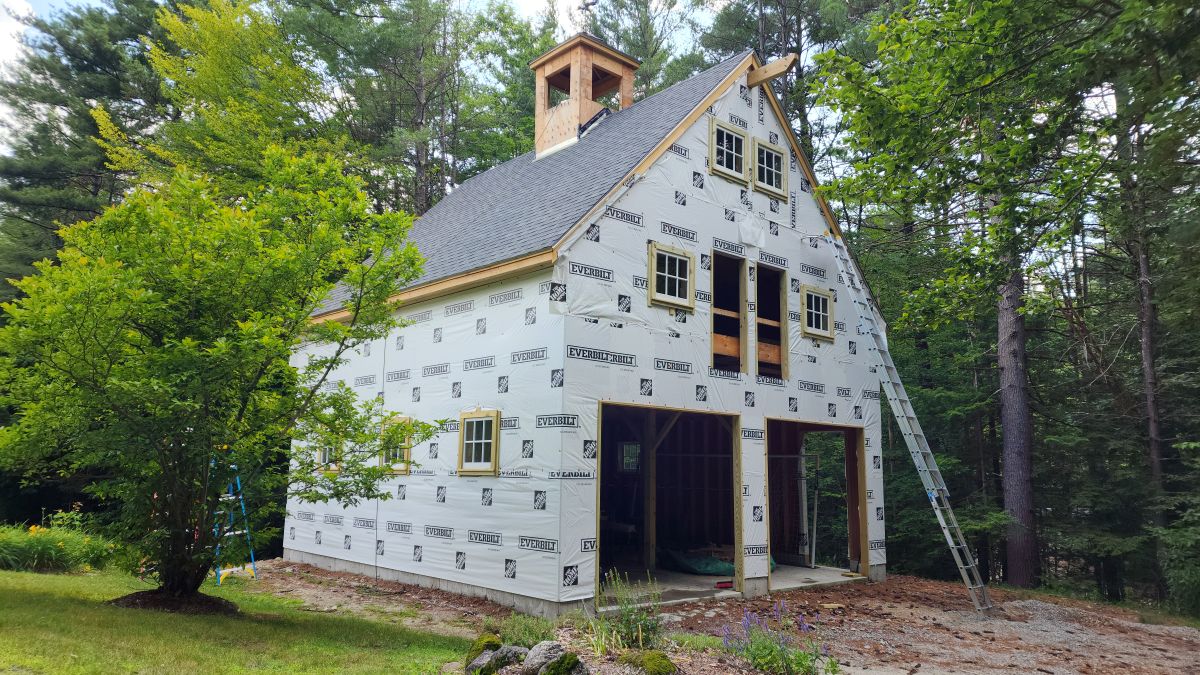
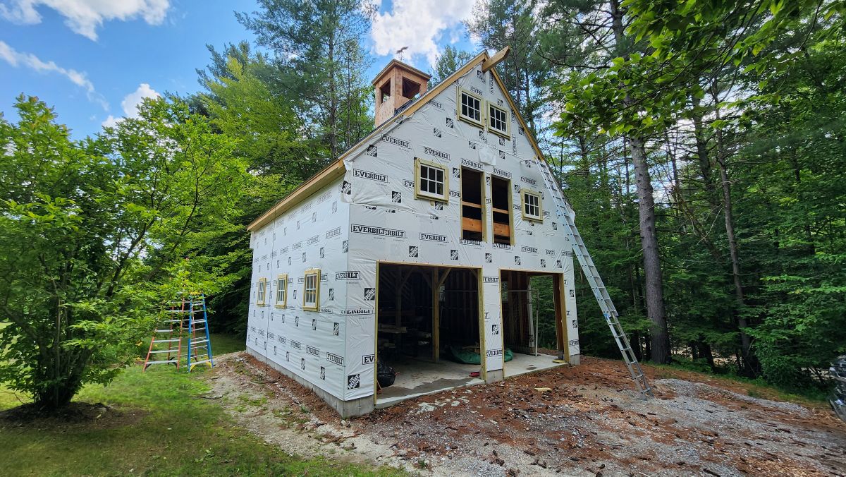
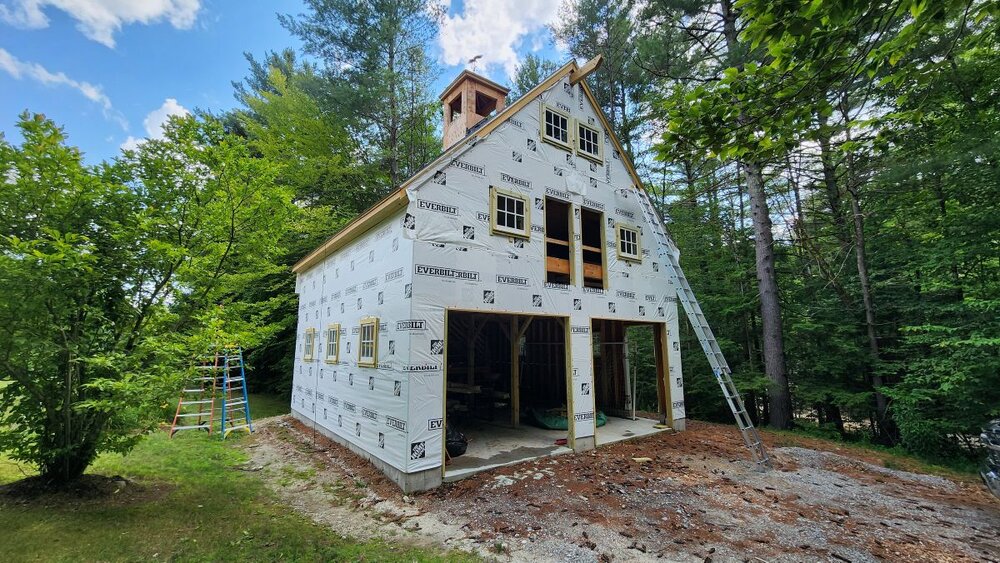
Barn update. Should be done by summer's end. I recommend checking for paper wasp nests before sticking your hands up underneath trim, especially when you are at the very end of a 32' extension ladder. Only the second time I've ever been stung, and I can confirm that it still hurts like a m'fer.

-
WE blew some off last night at my friends but there was no debris in anyone's yard other than his which we cleaned up. Treehouse put on quite a display of fireworks last night. Every time we thought it was the finale they kept on going.
-

July 2025 Obs/Disco ... possible historic month for heat
DavisStraight replied to Typhoon Tip's topic in New England
You're a mensch to take care of your dog after all that. -
House across from my next door neighbor. There wasn’t a lot, but I’m sure the radius around him from there to here is a mess. When my next door neighbor on the other side set them off in 2020 I picked up about 100pcs of various debris over 3hrs on my property on the lawn and woods.
-
Great Lakes cutters, I-95 to I84 huggers, and suppressed Southern Stream storm tracks have been dominant since the 2018-2019 winter. This is what we have had with the much stronger Pacific Jet. With the Great Lakes Cutter track the fast Pacific flow carves out a trough out West and pumps the Southeast Ridge with an I-95 rainstorm. The hugger track has wave spacing issues due to too many short waves in the fast Pacific flow. So we get the brief light to sometimes moderate snows changing to rain. Then there is the suppressed Southern Stream low due to the fast Pacific flow having a kicker trough coming into the West Coast. This doesn’t allow the Gulf low like the one last winter which gave record snows to the Gulf Coast to turn the corner and come up the coast. Then sometimes the lows come far enough north for DC to get snows but not areas further north. So the fast Pacific flow effectively turns off the benchmark snowstorm track. I hope we can see at least a small relaxation of this pattern in the coming years even if we still stay warm. Would take a warm and snowy La Niña winter like 16-17 and a weaker Pacific Jet in a second if I could get it. Wouldn’t mind a 60° day before of after some of the blizzards that season. Now we just get the 60° days without the great snows.
-
July 2025 Obs/Disco ... possible historic month for heat
DavisStraight replied to Typhoon Tip's topic in New England
Another black locust? -
Who's fireworks debris ended up in your yard?
-

July 2025 Discussion-OBS - seasonable summer variability
winterwarlock replied to wdrag's topic in New York City Metro
That's what I'm worried about..models and mets have been all over the map this year...days that are forecasted less seem to ovrrperform and vice versa -

July 2025 Discussion-OBS - seasonable summer variability
Brian5671 replied to wdrag's topic in New York City Metro
models don't have all that much-maybe .50 to 1.00. It will come down to how it interacts with an incoming cold front. But seems like in and out-not sure where this days and days of rain is coming from. - -
July 2025 Discussion-OBS - seasonable summer variability
winterwarlock replied to wdrag's topic in New York City Metro
So what's the deal with Chantals waste..is this a serious threat for heavy rain..surprised this board is crickets -

July 2025 Discussion-OBS - seasonable summer variability
steve392 replied to wdrag's topic in New York City Metro
Is the air quality alerts because of all the fire works smoke? -

July 2025 Discussion-OBS - seasonable summer variability
nycwinter replied to wdrag's topic in New York City Metro
since when are temps taken at airports like newark and laguardia really accurate compared to central park.. -

2025-2026 ENSO
Stormchaserchuck1 replied to 40/70 Benchmark's topic in Weather Forecasting and Discussion
Down near Baltimore and DC it was a snowy January. I had snow on the ground pretty much the whole month. They had a 8-10" storm further south than I think another 6" storm.. it snowed like 15 days through the end of January.. not a horrible Winter. I understand further north it was drier, but sometimes early in the Winter the STJ is further south. -
Literally every single chance we had at a KU event last winter from the end of November right through the end of March from PHL to NYC to BOS imploded. It found every way possible and then some to avoid a major snowstorm in that corridor. It was surreal
-
This summer reminding me of 2018. Consistently above average temps but no extraordinary heat, no good cold fronts, lake shadow, little rain.
-
Yup. Debris in my front yard from the shit. Fireworks should be banned. If you want to see them go to the town shows. It’s ridiculous.
-
Oh sorry no I mean it moved so slow that was the rate. Lake Travis went up 10’ in 2 hours this am.
-
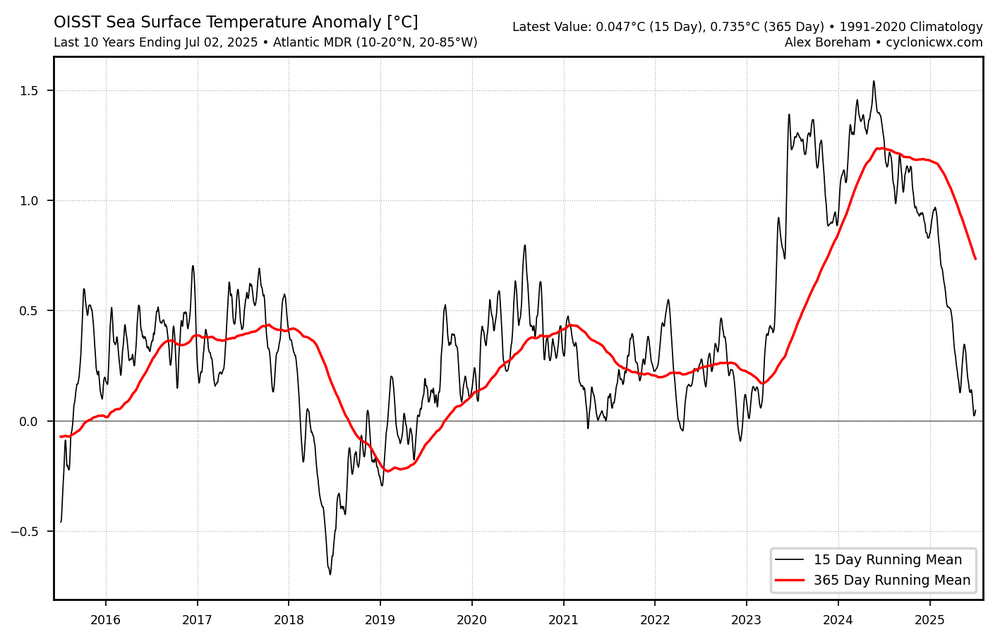
Last 10 yrs: Subtropical Pac: Subtropical ATL: ATL MDR:


- Today
-
2025-2026 ENSO
Stormchaserchuck1 replied to 40/70 Benchmark's topic in Weather Forecasting and Discussion
How did it snow 10" in Florida? How did Valentine, Nebraska hit -31F when it was almost March? I was on this board saying that the pattern wasn't good for snow last February and that it wasn't going to snow.. I would dig it up, but there were like 10-15 posts about this in the Mid Atlantic forum. The NAO was south-based positive and there was High pressure in the North Pacific over the North Pacific High position. Plus it takes some time to detox the heavy -PNA/+AO that was the time before. Not a big anomaly. The big anomalies were Dec 2022 and March 2023, but teleconnection patterns aren't 100%, and sometimes other things dominate. Doesn't mean it's always going to be like that. I think we are going back to -NAO cold in the Winter time as Jan 2024 and Jan 2025 had this. The coastal SLP correlation is 5-6x greater in -NAO/+PNA than +NAO/-PNA. I should dig up those old posts... was saying it wasn't a great H5 pattern for snow that 5-7 day models were showing. We didn't have things at our latitude that were favoring cold and snow like a 50/50 low and NE N. Pacific low pressure. bluewave by your posts I would surmise that you are saying NYC is going to average 15"/snow/yr from here on out. No matter, regardless. I don't think that's going to happen... we might have a tough few years with the flux of some things still being unfavorable, but weather patterns wax and wane.. eventually we will enter a better pattern, and the global warming isn't that advanced yet. -
peaked boomped to 50mph
-

July 2025 Discussion-OBS - seasonable summer variability
Sundog replied to wdrag's topic in New York City Metro
I'm working on an extensive post regarding the issue -

July 2025 Discussion-OBS - seasonable summer variability
bluewave replied to wdrag's topic in New York City Metro
Absolutely. Just compare the old photos of the site from the recent ones. Most of those 100° readings from the 1930s into the early 1990s would have only been mid to upper 90s if the they had the same tree cover back then. The strongest wind gust is still 78 mph set back in December of 1974 when the trees were much lower. So there could have been higher gusts in the interim but the tress could be interfering like with the temperatures.

-
July 2025 Obs/Disco ... possible historic month for heat
weatherwiz replied to Typhoon Tip's topic in New England
I would but I’d be lying