All Activity
- Past hour
-
Down to 53 here last night. Was great to sleep with the windows open and the blankets up.
-
(002).thumb.png.6e3d9d46bca5fe41aab7a74871dd8af8.png)
Central PA Summer 2026 Discussion/Obs Thread
ChescoWx replied to Voyager's topic in Upstate New York/Pennsylvania
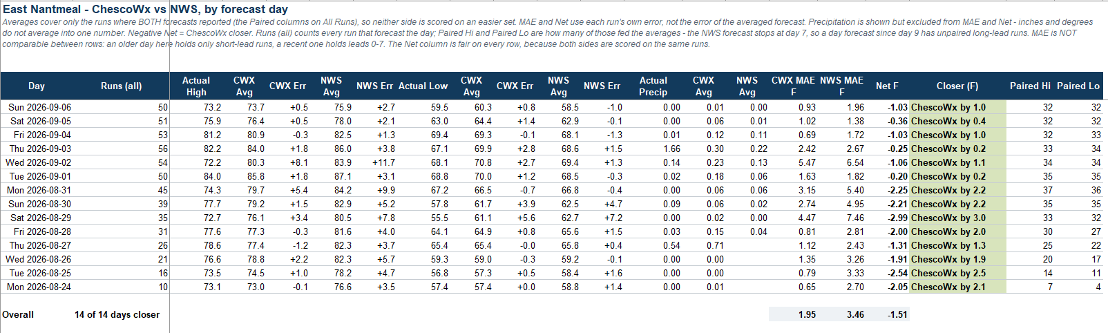
With now 2 weeks of forecasts in the books the ChescoWx model has performed a bit better than the official NWS forecast every day for my backyard here in East Nantmeal Township.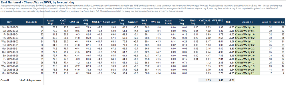
-
E PA/NJ/DE Autumn 2026 Obs/Discussion
ChescoWx replied to PhiEaglesfan712's topic in Philadelphia Region
With now 2 weeks of forecasts in the books the ChescoWx model has performed a bit better than the official NWS forecast every day for my backyard here in East Nantmeal Township.
-

2026-2027 Record-breaking El Nino
Chinook replied to Stormchaserchuck1's topic in Weather Forecasting and Discussion
I am wondering how the El Nino may already be shifting 250mb winds, even as we've just started, in summer. Obviously, we'll expect lots of subtropical jet in winter. As for now, I used the HISTDATA from NOAA to plot this... it's essentially the same as NCEP/NCAR reanalysis but it lacks some capabilities. Anyway, the 250mb zonal winds have been more westerly than average for some of the E Pacific, into southern Mexico, then out to the Atlantic. You can see the evidence of a ridge over the central USA. Now, we know El Nino tends to have these situations where the wind shear is quite high for the Atlantic hurricane season and squash that. But here's the question: if the 250mb winds were so westerly, why has the E Pacific generated some strong storms? Of course, on here, there's the Hawaii area ,which has had a hurricane this summer (and now a couple more storms by Hawaii), with the more-easterly-than-average winds as shown. -

2026-2027 Record-breaking El Nino
GaWx replied to Stormchaserchuck1's topic in Weather Forecasting and Discussion
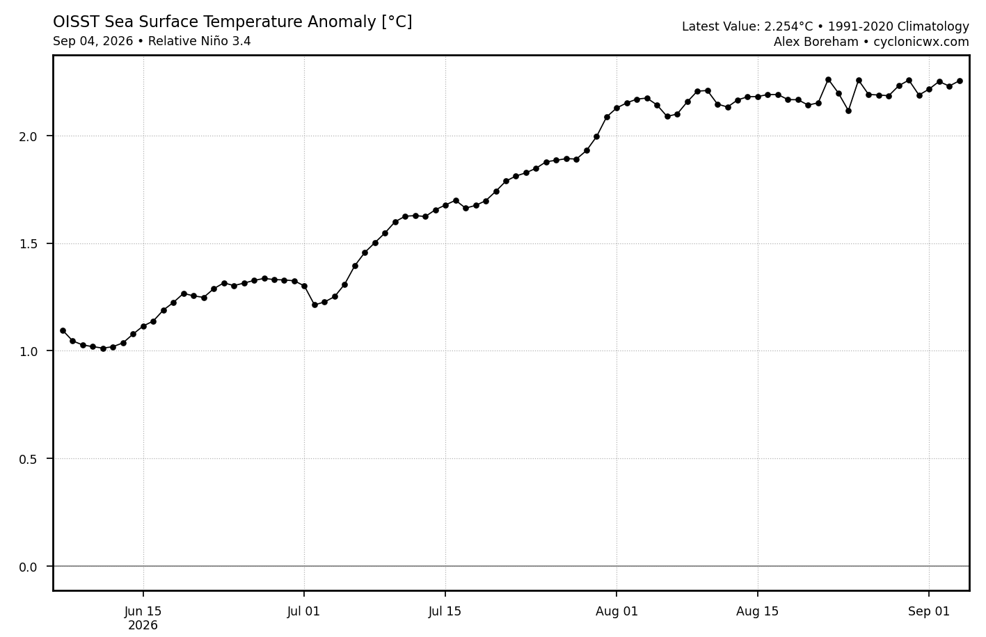
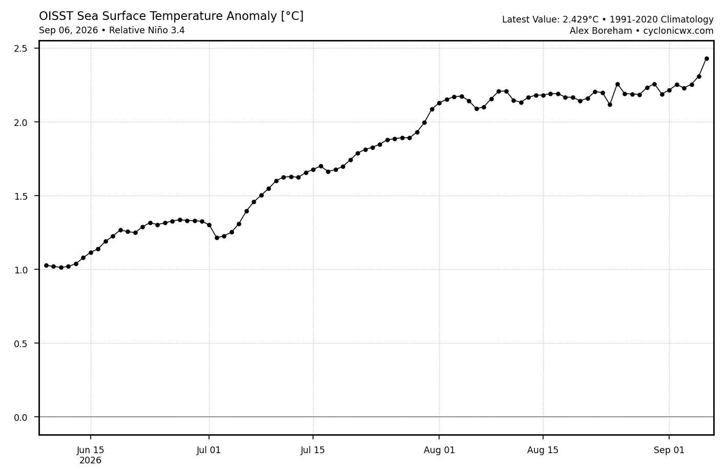
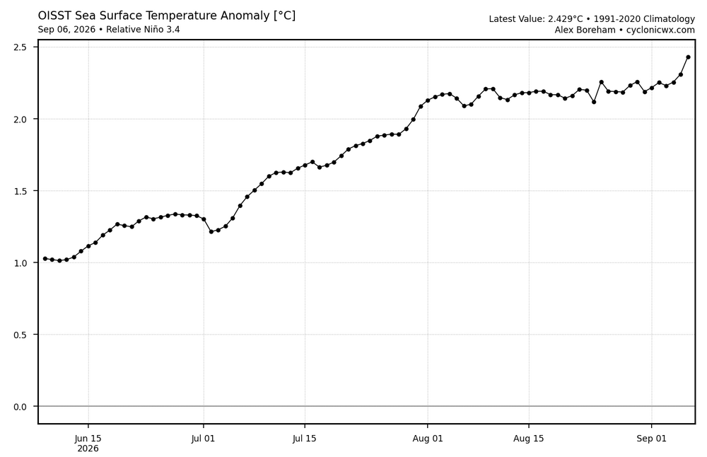
After being pretty flat in August/first few days of Sept, the relative 3.4 OISST anomaly has risen sharply the last two days: Sept 4th relative 3.4: +2.254 Sept 6th relative 3.4 anomaly: +2.429, a rise of 0.175 in just two days…that’s the most rapid two day rise on this entire chart as it is the most rapid two day rise since June 3rd-5th, which is not on this chart: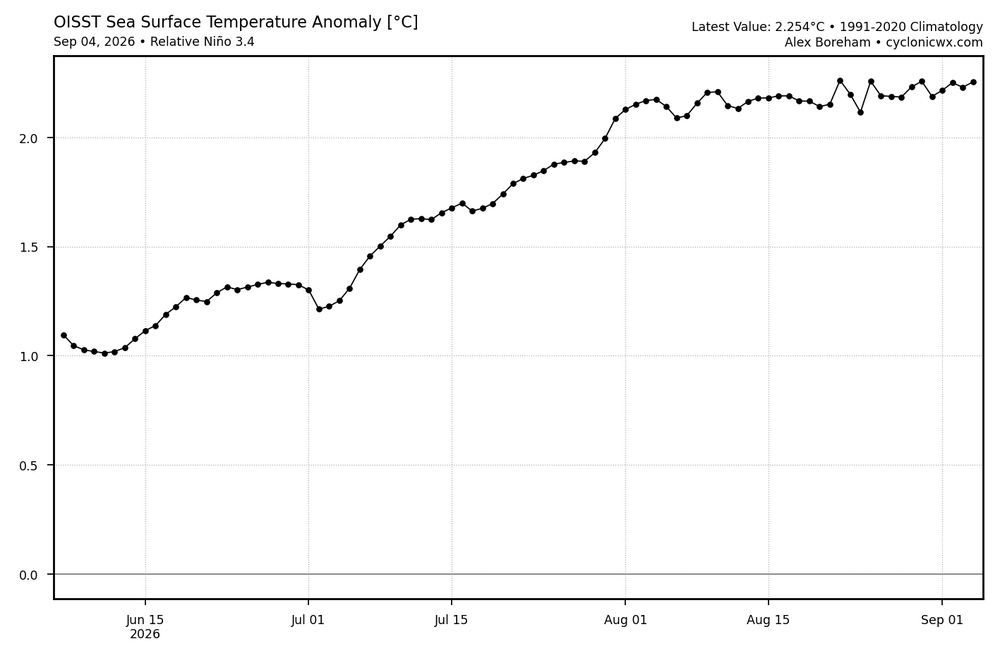
-
Dipped below 60 for the first time at my location since mid-June. Very cool feel this morning but it's rebounding quickly through the low 80s right now. Great windows open weather to let some of this dry air flow in.
-

Winter 2026-2027 Speculation
Prismshine Productions replied to 40/70 Benchmark's topic in New England
-5 for me is still 50+" so would take in a heartbeat Sent from my SM-S176V using Tapatalk -
2026-2027 Record-breaking El Nino
GaWx replied to Stormchaserchuck1's topic in Weather Forecasting and Discussion
The daily WCS PDO has risen back substantially the last 7 days ending yesterday with it up to -0.9, the highest since way back on July 2nd, vs ~-1.65 one week earlier: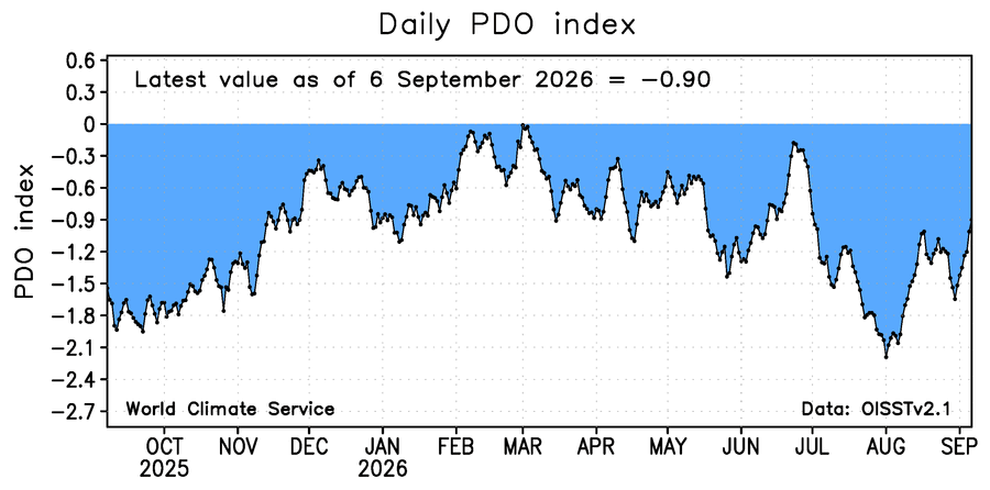
-
2026-2027 Record-breaking El Nino
GaWx replied to Stormchaserchuck1's topic in Weather Forecasting and Discussion
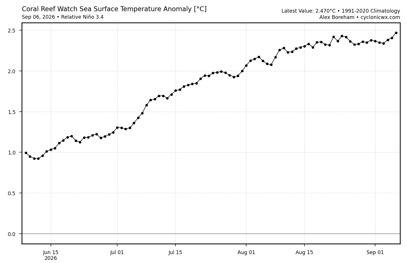
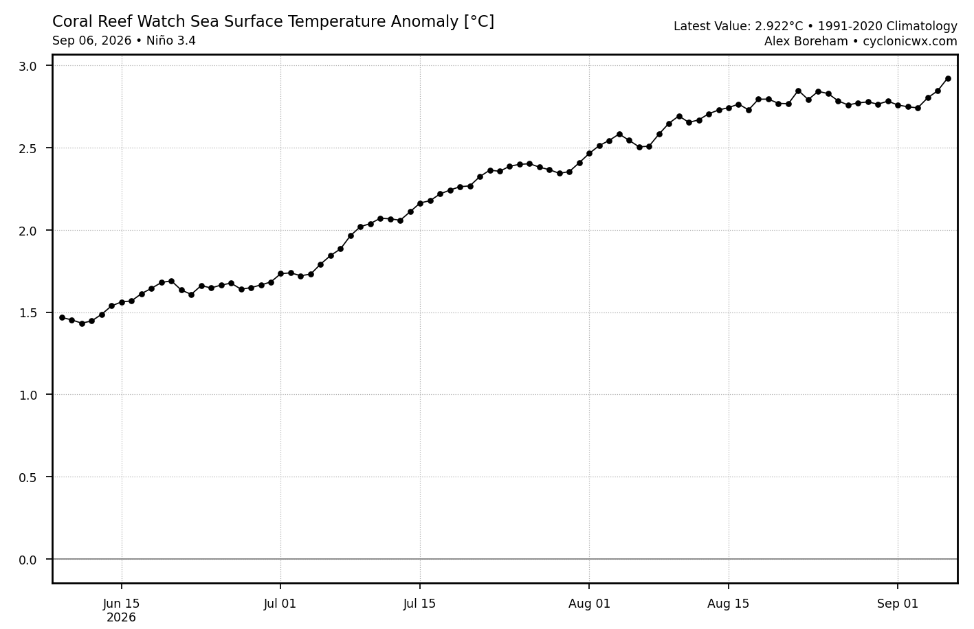
Here’s the version of CRW anomalies for Nino 3.4 that best takes into account GW in determining anomalies: it’s +2.5C and rising: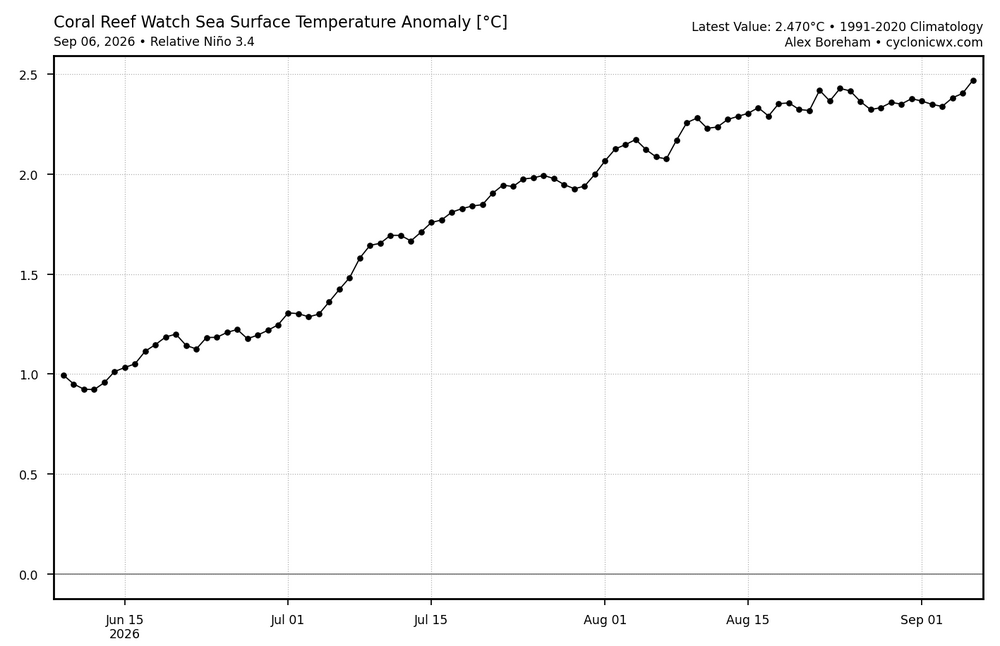
-
 where to get nolvadex: NolvaCare :: effexor and tamoxifen
 -
Hello all. The ChescoWx website https://chescowx.com has had a major overhaul and it is now live! Everything is interactive now. You can pull up climate trends unique to the Philly burbs of Chester County PA for any measure, look at a single station or the whole county, and compare us against Philadelphia, Reading, or Allentown airports. There are all time records, decade summaries and climate trending options going back to the 1870's, top snowstorms, snow by season and even a White Christmas history. Every trend also tells you whether that trend is statistically significant or simply weather noise. Behind the enhanced website sits 42 Chester County area stations and more than 458,000 daily observations going back to 1871. Take a look and let me know what you think and what we are missing you would like to see or be able to view interactively. Thanks! Paul
-

2026-2027 Record-breaking El Nino
George001 replied to Stormchaserchuck1's topic in Weather Forecasting and Discussion
A rouge blizzard is certainly possible, but things don’t look good for northern areas. I agree that 27-28 will offer better chances for sustained winter weather. I would much rather roll the dice with a La Niña than a super Nino. Although weak La Niña is preferred, even in some stronger La Niña years my area has gotten hit hard at times. I dont think there has been even one super El Niño year with AN snowfall locally, and all of them are AN to well AN temps. Even the “better” super Nino analogs like 15-16, 82-83 etc were warm with below average snowfall (82-83 was closer to average, but still a bit below and was warm, so still a bad winter by my standards). - Today
-

2026-2027 Record-breaking El Nino
LakePaste25 replied to Stormchaserchuck1's topic in Weather Forecasting and Discussion
Almost to +3C on CRW. CRW mostly measures surface temps, so at some point I would expect it to mix down which would increase OISST but decrease CRW.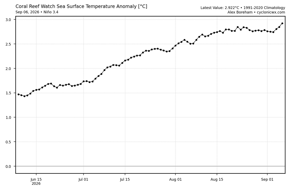
-

Septorcher 2026 Discussion - Endless Summer
dendrite replied to Damage In Tolland's topic in New England
Mins this morn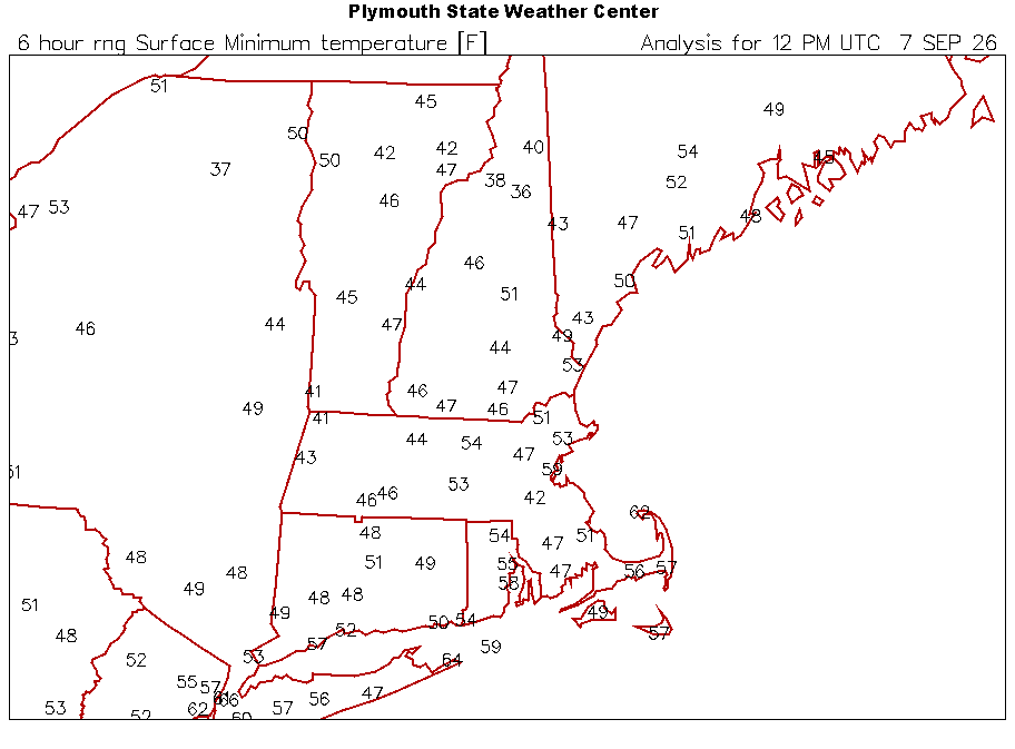
-
Essentially us in New England are closing the shades until Winter 27-28 Sent from my SM-S176V using Tapatalk
-

E PA/NJ/DE Autumn 2026 Obs/Discussion
JTA66 replied to PhiEaglesfan712's topic in Philadelphia Region
Getting to that time of year now where I focus on the overnight lows. It can be warm during the day, as long as it cools off enough for good sleeping weather. 74F/DP 56F -
2026-2027 Record-breaking El Nino
LakePaste25 replied to Stormchaserchuck1's topic in Weather Forecasting and Discussion
LFG! Been waiting for this to happen. -
Central PA Summer 2026 Discussion/Obs Thread
ChescoWx replied to Voyager's topic in Upstate New York/Pennsylvania
Hello all. The ChescoWx website https://chescowx.com has had a major overhaul and it is now live! Everything is interactive now. You can pull up climate trends unique to the Philly burbs of Chester County PA for any measure, look at a single station or the whole county, and compare us against Philadelphia, Reading, or Allentown airports. There are all time records, decade summaries and climate trending options going back to the 1870's, top snowstorms, snow by season and even a White Christmas history. Every trend also tells you whether that trend is statistically significant or simply weather noise. Behind the enhanced website sits 42 Chester County area stations and more than 458,000 daily observations going back to 1871. Take a look and let me know what you think and what we are missing you would like to see or be able to view interactively. Thanks! Paul -
E PA/NJ/DE Autumn 2026 Obs/Discussion
ChescoWx replied to PhiEaglesfan712's topic in Philadelphia Region
Hello all. The ChescoWx website https://chescowx.com has had a major overhaul and it is now live! Everything is interactive now. You can pull up climate trends unique to the Philly burbs of Chester County PA for any measure, look at a single station or the whole county, and compare us against Philadelphia, Reading, or Allentown airports. There are all time records, decade summaries and climate trending options going back to the 1870's, top snowstorms, snow by season and even a White Christmas history. Every trend also tells you whether that trend is statistically significant or simply weather noise. Behind the enhanced website sits 42 Chester County area stations and more than 458,000 daily observations going back to 1871. Take a look and let me know what you think and what we are missing you would like to see or be able to view interactively. Thanks! Paul -

2026-2027 Record-breaking El Nino
forkyfork replied to Stormchaserchuck1's topic in Weather Forecasting and Discussion
-

2026 Atlantic Hurricane Season
LongBeachSurfFreak replied to Stormchaserchuck1's topic in Tropical Headquarters
I still think the best chance of anything more then a sheared mess comes out of the subtropics late sept into oct. likely starting a subtropical system and taking advantage of above normal water temps. The Mdr is toast. . -
2026-2027 Record-breaking El Nino
forkyfork replied to Stormchaserchuck1's topic in Weather Forecasting and Discussion
so stop looking at it? i don't even look at the gfs -
generic propecia without rx: get propecia tablets - cost of propecia for sale
-
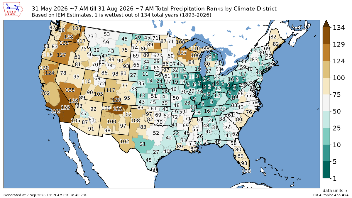
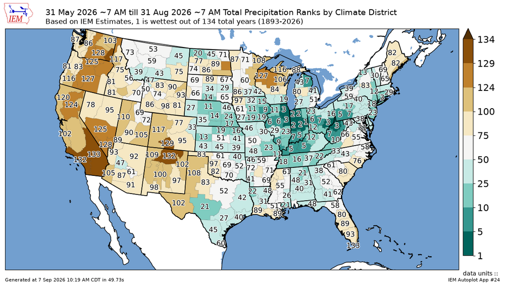
Relatively cooler over the Midwest due to the record rainfall with the severe storms leading to the new tornado record for Illinois.
-
buy cytotec online fast delivery: CytoCarePharma :: Abortion pills online