All Activity
- Past hour
-
43 for the Marysville low.
-

October Comes Early: Late September Multi-Hazard Hybrid Storm
WinterWolf replied to WxWatcher007's topic in New England
Lol…ahh to be young again with thoughts of canes and destruction. -
Looking more like a damp/rainy weekend for here. Forecast has max rainfall of an inch or so.
-

Strong Nor'Easter/Hybrid Storm Late September 2026
wthrmn654 replied to Rjay's topic in New York City Metro
Wow 6z gfs raises my area tide forecast yet again.. over 6 feet -
Good thing we didn't! The storm could of looped around and hit us and we'd be stuck talking about it in the obs thread. Anyway.. if this was winter I'd be celebrating this morning. West of DC. Not so much. Love me a Nina pattern lol
-
35 degrees this morning
-

October Comes Early: Late September Multi-Hazard Hybrid Storm
CoastalWx replied to WxWatcher007's topic in New England
Kid thinks category 1 or bust. -
36.7 this morning. Colder than yesterday.
-

Strong Nor'Easter/Hybrid Storm Late September 2026
bluewave replied to Rjay's topic in New York City Metro
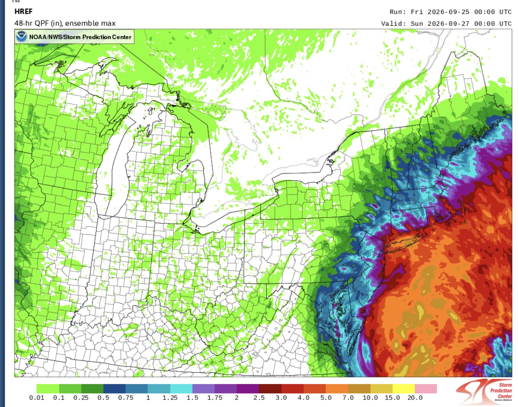
Latest SPC HREF Max is similar to the RGEM showing 5”+ potential on Long Island where the best banding develops NW of the center. But the location of these bands often shifts right up to storm time. So we’ll have to review again later with the new guidance today.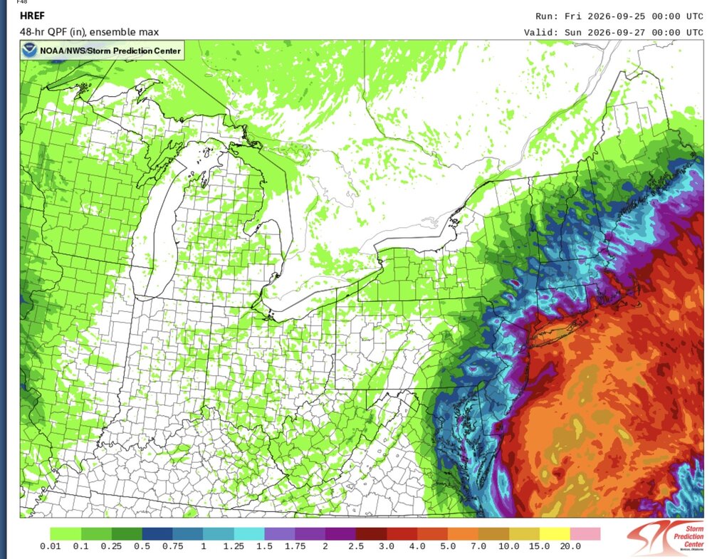
-

Strong Nor'Easter/Hybrid Storm Late September 2026
qg_omega replied to Rjay's topic in New York City Metro
Standard Nor’easter without the snow, periods of rain on and off with breezy conditions, nice fall weekend -

October Comes Early: Late September Multi-Hazard Hybrid Storm
Baroclinic Zone replied to WxWatcher007's topic in New England
Looking like a lotta rain with moderate level winds here. Will be a fun storm. Just sucks to lose 3 days. -

October Comes Early: Late September Multi-Hazard Hybrid Storm
weatherwiz replied to WxWatcher007's topic in New England
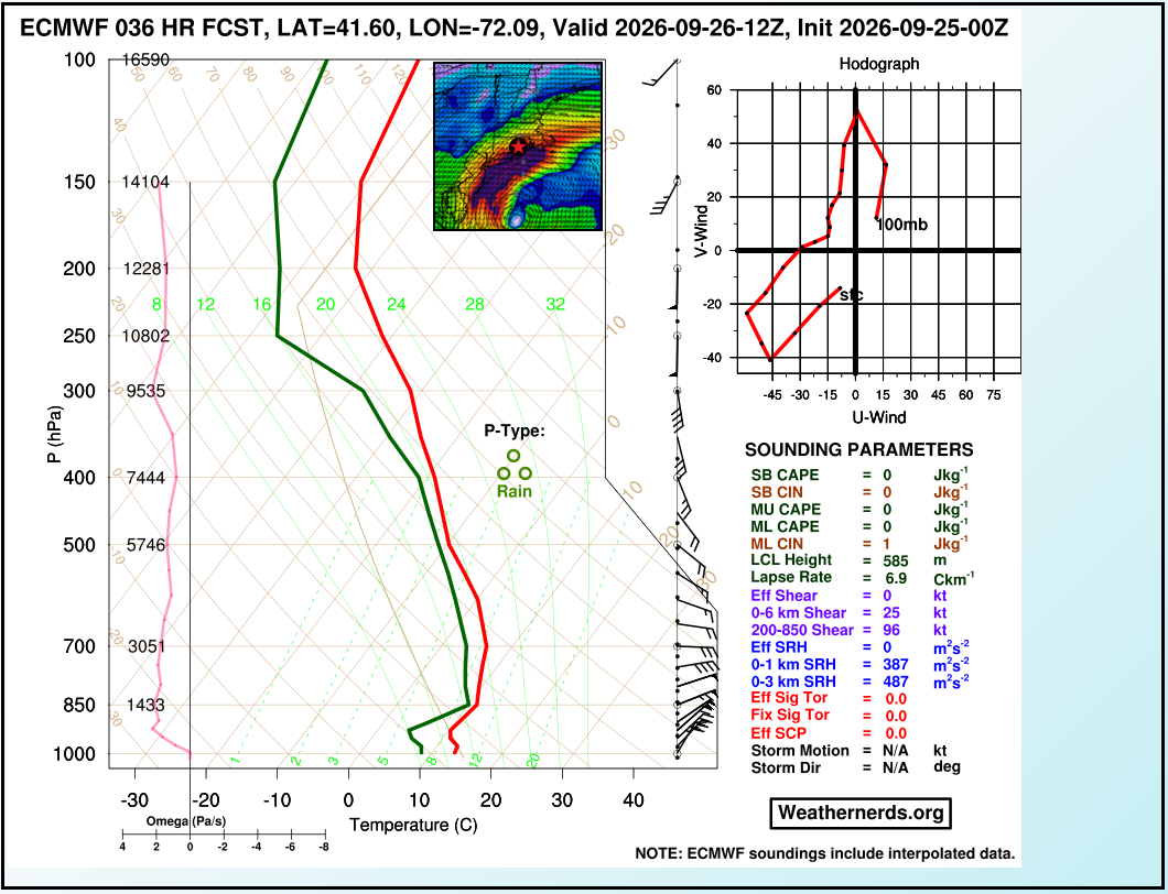
Yeah looking at some euro soundings for tomorrow morning inland CT there is a shot we can gust 40-50 even inland, especially the eastern half of the state -

Strong Nor'Easter/Hybrid Storm Late September 2026
ForestHillWx replied to Rjay's topic in New York City Metro
Seems rather quiet in here for what’s about to likely unfold on the Tri-state area. I am slightly more concerned what might happen from a power perspective, compared to projected rainfall, in light of fully leafed out trees in my area. -
October Comes Early: Late September Multi-Hazard Hybrid Storm
weatherwiz replied to WxWatcher007's topic in New England
Yeah there is a bit of an inversion but not particularly strong or very deep. I can still see the coast gusting 50-60 mph, particularly with any rain bands. But given how shallow the inversion is, we have to watch sfc temps very closely. Another 1-2F warmer and the inversion is weakened and may not do much in preventing some of those stronger winds from being tapped into.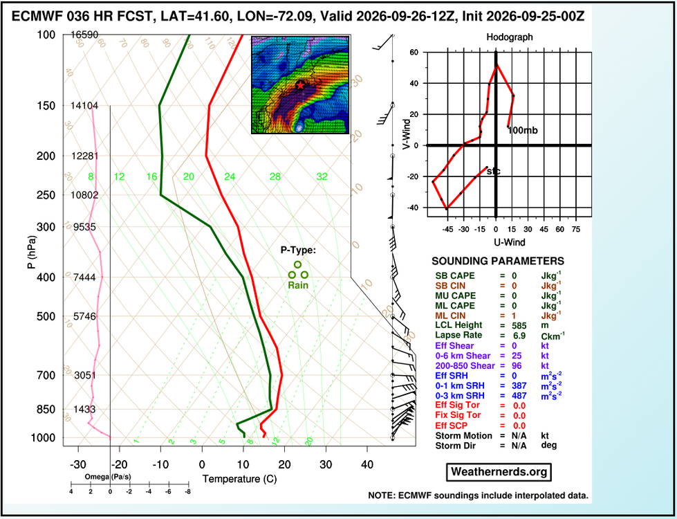
-
October Comes Early: Late September Multi-Hazard Hybrid Storm
WinterWolf replied to WxWatcher007's topic in New England
Be patient young Scoots….its just taking shape now. Let’s see what it looks like later today? -
 This is not even the strongest period of winds . This is after midnight Saturday. Wow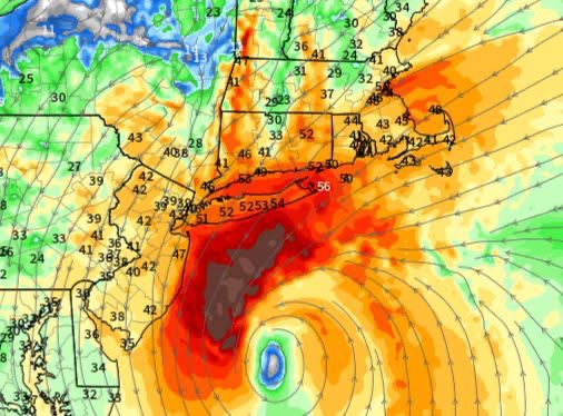
-
October Comes Early: Late September Multi-Hazard Hybrid Storm
qg_omega replied to WxWatcher007's topic in New England
I don’t understand the HWW up to and past Boston, doesn’t make any sense -

October Comes Early: Late September Multi-Hazard Hybrid Storm
Masswx replied to WxWatcher007's topic in New England
Got football canceled on Sunday too so this storm better be worth that too -
Soundings are willd statewide
-
HRRR is north and a ripper.
-
October Comes Early: Late September Multi-Hazard Hybrid Storm
Masswx replied to WxWatcher007's topic in New England
Soccer -

October Comes Early: Late September Multi-Hazard Hybrid Storm
Ginx snewx replied to WxWatcher007's topic in New England
Tonight? What sport? Beer pong? -
2026-2027 Record-breaking El Nino
bluewave replied to Stormchaserchuck1's topic in Weather Forecasting and Discussion
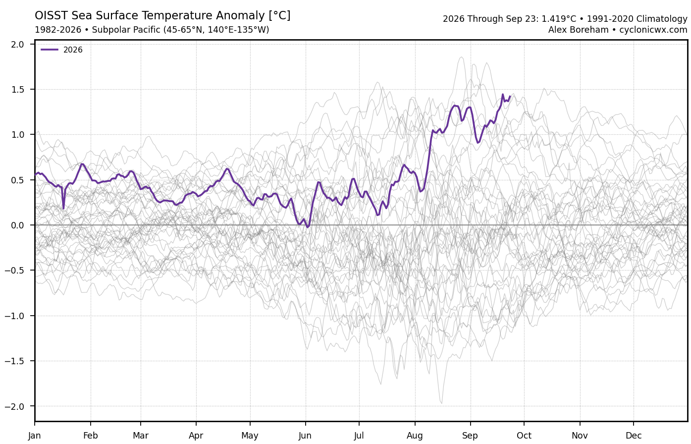
Another PDO drop as we approach the all-time warmest SSTs this time of year ENE of Japan and south of the Aleutians.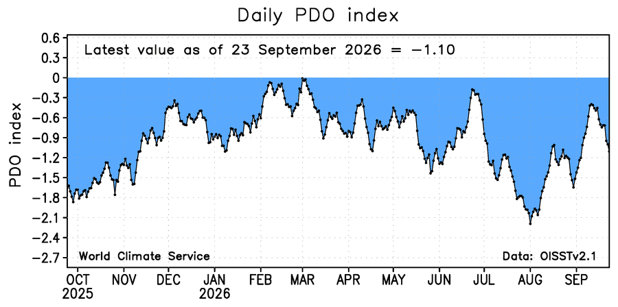
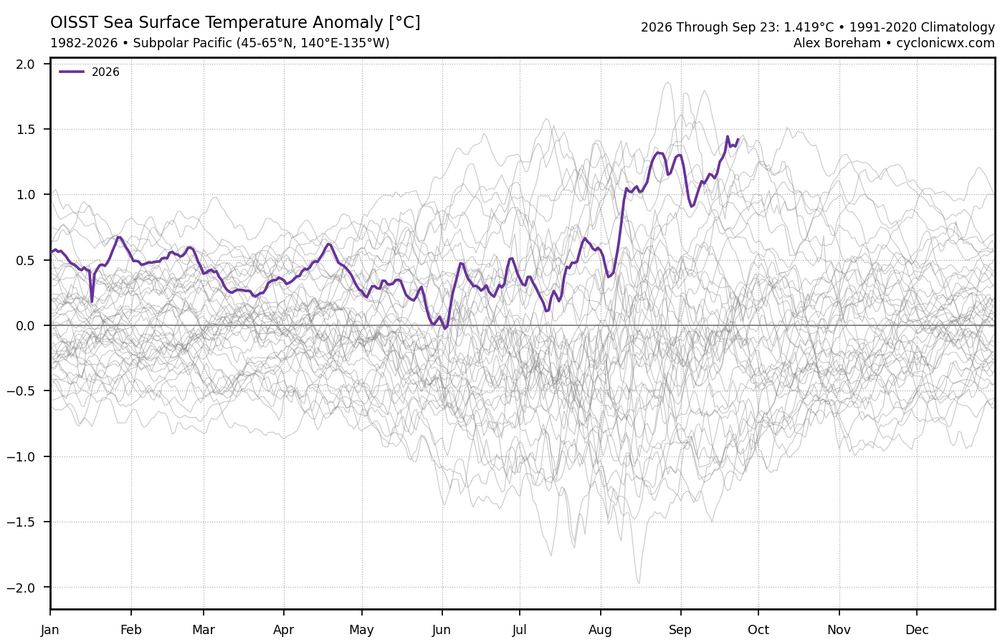
-
October Comes Early: Late September Multi-Hazard Hybrid Storm
Ginx snewx replied to WxWatcher007's topic in New England
IDK could be the Euro ocean coupled is sensing upwelling leading to an inversion.png.324a2c57c336370e48246086cca71df5.png)
-
October Comes Early: Late September Multi-Hazard Hybrid Storm
Masswx replied to WxWatcher007's topic in New England
Not worth canceling my sports games tonight