All Activity
- Past hour
-
Euro says 100 degrees and running.
-
0.00". Temp has cooled down to 80 from the outflow. Too bad I'm now done with my yardwork. The cell that went through Garner looked bad.
-
So why did you weenie the original post in the first place?
-
.thumb.jpg.6a4895b2a43f87359e4e7d04a6fa0d14.jpg)
Central PA Summer 2026 Discussion/Obs Thread
Yardstickgozinya replied to Voyager's topic in Upstate New York/Pennsylvania
Generally we dry out after the main vegetative cycle is over. Drying out like this while things were in their main vegetative stage isn't something we see a whole lot, and it's going to be a lot worse then if it were later. It also may not be as bad for many of you as what i'm witnessing here, i've been missed by almost everything over the last a few weeks. -
just some light sprinkles and light rain here-nothing of consquence-back edge moving thru
-
So basically the active July pattern has collapsed? Or what if they’re right about the storm pattern but it’s a week later than they thought it would be?
-
I think the tstm/derecho threat will be confined the Northeast. 700 mb temps are too warm for deep convection here. +10 usually caps it off this part of the country, and they get as high as +13 this week and stay AOA +10 thru Fri. 1000-500 thk stays AOA 579 much this coming week, peaking at 583, which is typically too warm a column for tstms unless you have good forcing.
-
Again, every accusation is a confession.
-
I can't anymore lol. Like trying to reason with a petulant child. Good luck. I truly hope you are willing to try and improve enough as to not be a continuous annoyance here.
-
Speaking of TORs, looks like there may have been a brief spin up near Sussex County, DE today.
-
Thank goodness the camp I work a little at during the summer installed AC in the building I’m in. Those campers will be toast. They begin every day with a 7 mile run
-
By himself.
-
Every accusation is a confession.
-
Central PA Summer 2026 Discussion/Obs Thread
Yardstickgozinya replied to Voyager's topic in Upstate New York/Pennsylvania
I just took a walk i've been trying to avoid to assess edaphic stress on the lower layers.. This is another dire situation for our farmers, especially rubus field's without irrigation. BIosemiotic abortion has begun in all rubus and that won't be reversed even with rain at this point. -
Lest we forget! Washington DC ended a streak of 2867 days w/o 100 F reading on 6/22/2024. This is the 5th longest period on record since 1872. So "we're due" for a big heat wave??!! | Does this mean DMH will be 110? LOL. Actually, did they fix the issue b/c I look at the temps this month BWI vs. DMH, and high temps are close. June 11-12 -- both days 97 at BWI, and 98 at DMH. Still DMH seems to avg 1-2 F warmer for highs overall, but that's a *far* cry from the 5-7 F difference last year and before. BWI would be 97 and DMH would be 104, and that went into the official climate record! It appears now DMH just has the typical city UHI bias. Seems like when they did that construction a few years ago at the Science Center and DMH was offline for a while, it made the heat contamination worse. More concrete walkway all around and a solar farm within stone's throw. Just incompetent planning. It's like all these wind farms, and ground clutter contamination that occurs even far from WSR-88Ds. Take a look at DDC, VNX, and FDR, as examples. It's really bad. Eventually, there is going to come a time when a TOR is missed due to this wind farm clutter and lives lost I'm afraid.
-
Meh. Could be. But it could also be decent.
-

2026-2027 Super El Nino
Stormchaserchuck1 replied to Stormchaserchuck1's topic in Weather Forecasting and Discussion
09-10 was big +PNA. It was actually +PNA every month from June 2009 to April 2010 -
Dude you got nothing. You keep coming back to that which is nonsensical, and you still don't get the point of me mentioning that. Fuck man, take a break.
-
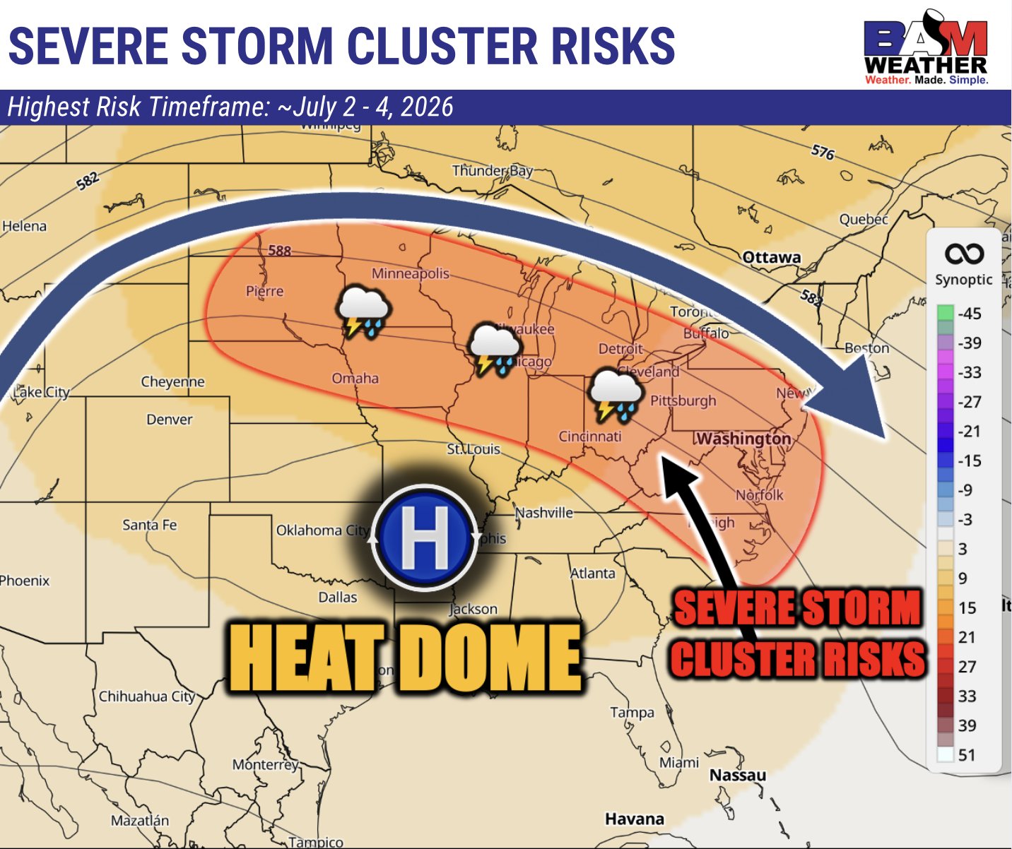
I wonder Bam was onto something when they posted this on Monday then? Still pinned on the twitter btw.

-
The time to watch will be when the heat wave breaks. That's when I'll be on derecho watch.
-
I don't crash out when I get weenie'd so...
-

E PA/NJ/DE Summer 2026 Obs/Discussion
JTA66 replied to PhiEaglesfan712's topic in Philadelphia Region
Eleven drops, maybe 12. 73F/DP 66f -
That's not what they said. You aren't very bright. "a tenth of an inch or less except higher amounts possible in thunderstorms" is standard wording when storms are expected to be isolated to scattered, but not widespread- as in a consolidated QLCS line. Models were indeed depicting the former. Try again? Maybe take the L and move on. Then try harder to become a decent poster.
-
EPS is 90s even for the 4th.
-
Went back and took another look at the 06/12z GFS. They both try to pop a 597dm ridge at the peak of the heat on Friday into Saturday. If this holds, then it open the doors to some possibilities: Scattered or even widespread 100 degree air temperatures are possible Thur - Sat The strength and placement of the ridge would preclude afternoon convection Low temperatures may fail to fall below 80 degrees, perhaps even the low 80s in the Urban Heat Islands We might see the heat wave tail into the end of the weekend