All Activity
- Past hour
-
Reminder to NYC participants to visit contest thread with or without costumes by 31st.
-

Major Hurricane Melissa - 892mb - 185mph Jamaica landfall
Windspeed replied to GaWx's topic in Tropical Headquarters
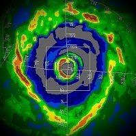
Huge thanks to Brian McNoldy at the Rosenstiel School of Ocean and Atmospheric Science at Miami for editing the full loops together for which I sourced these. I am posting these for posterity. Rarely do we have radar loops that show full eyewall mergers instead of eyewall replacement cycles. I will post both the short range and long range. Keep in mind the short range has limited/degraded echoes due to distance. But you can still make out the moat and concentric outer band/eyewall that was organizing in Melissa prior to the inner eyewall becoming dominant and absorbing them. The only other intense hurricane that we have radar evidence of this phenomenon is Irma prior to its landfall in the Lesser Antilles. There is much to be learned about these type of events and how they occur. Most likely, when environmental conditons are near to perfect/pristine and an inner eyewall reaches a certain degree of stability, it will not succumb to outer concentric banding, but pull those bands in and absorb them. As we can see Melissa do in these loops, the dominant eyewall becomes extremely intense after the final merger before it goes on to become a sub 900 hPa hurricane. There is probably a doctorial degree for someone here. It just requires extensive research. Short range: Long range: -
Huh. Just got a clap of thunder near Gainesville.
-

Spooky Season (October Disco Thread)
H2Otown_WX replied to Prismshine Productions's topic in New England
There's the kiss of death. December 2001/2011 incoming. -

Major Hurricane Melissa - 892mb - 185mph Jamaica landfall
Coach McGuirk replied to GaWx's topic in Tropical Headquarters
Mellissa was a tiny hurricane, most cat 5s are that way. - Today
-
Major Hurricane Melissa - 892mb - 185mph Jamaica landfall
GaWx replied to GaWx's topic in Tropical Headquarters
For much of the time hurricane force winds extended outward only 30 miles. Now it is up to 60 miles while TS force extend about the same as they’ve been: From NHC 11PM advisory: Hurricane-force winds extend outward up to 60 miles (95 km) from the center and tropical-storm-force winds extend outward up to 185 miles (295 km). -

Major Hurricane Melissa - 892mb - 185mph Jamaica landfall
Coach McGuirk replied to GaWx's topic in Tropical Headquarters
I think it was this typhoon. He deleted the part when his friend was injured and the glass blew out. -
Right at 1 inch down here now... Cold rainy night...
-
The 18z GFS around D11 had a 1-3 inch snow for the Plateau/SWVa with more along the mountains. Around .5 to 1 inch for most of the mid-state. One of the first shots fired for accumulating snow across the lower elevations. The 12z had it but over a smaller area. Basically less than a half inch over Campbell/Scott/SE Ky/SWVa and heavier snow in the higher eastern mountains. I doubt it will still be there on the 0z.
-
1.1 inches of rain today, 3.6 inches this week so far.
-
Major Hurricane Melissa - 892mb - 185mph Jamaica landfall
GaWx replied to GaWx's topic in Tropical Headquarters
-

Major Hurricane Melissa - 892mb - 185mph Jamaica landfall
OrangeCTWX replied to GaWx's topic in Tropical Headquarters
It seems like it takes a special breed lol Reed Timmer with tornados, Josh with hurricanes etc. -

Major Hurricane Melissa - 892mb - 185mph Jamaica landfall
Coach McGuirk replied to GaWx's topic in Tropical Headquarters
It was a direct hit on Taiwan as a cat 5 in hurricane terms. I can't believe this storm has been scrubbed. Josh was there. -
RAIN sheets of heavy rain now
-

Major Hurricane Melissa - 892mb - 185mph Jamaica landfall
Coach McGuirk replied to GaWx's topic in Tropical Headquarters
Maybe it was Morokat after all. I thought it was later. -

Major Hurricane Melissa - 892mb - 185mph Jamaica landfall
Windspeed replied to GaWx's topic in Tropical Headquarters
Ok, hrmm... I might be getting some of his old footage mixed up. I think I'm confusing that with when Reynolds was chasing with him. -

Major Hurricane Melissa - 892mb - 185mph Jamaica landfall
Coach McGuirk replied to GaWx's topic in Tropical Headquarters
No it was Taiwan probably 10 years ago. -

Major Hurricane Melissa - 892mb - 185mph Jamaica landfall
Windspeed replied to GaWx's topic in Tropical Headquarters
I think what you are describing was when Super Typhoon Haiyan made landfall near Tacloban, Philippines. Come to think of it, that means Josh has been in the most intense Pacific landfall and the most intense Atlantic landfall in the satellite era. -

Major Hurricane Melissa - 892mb - 185mph Jamaica landfall
Coach McGuirk replied to GaWx's topic in Tropical Headquarters
I remember he was chasing a very strong Typhoon that hit Taiwan. The hotel he was in got blown out and his friend got serious cuts on his arm. -

Major Hurricane Melissa - 892mb - 185mph Jamaica landfall
WEATHER53 replied to GaWx's topic in Tropical Headquarters
Got to go on the epic Tug Hill Feb 2007 chase. -

Major Hurricane Melissa - 892mb - 185mph Jamaica landfall
Nibor replied to GaWx's topic in Tropical Headquarters
I think on journalistic level there is an importance to storm chasing. I can overlook some of the narcissism that comes with it (incoming cliche) as that's pretty much baked into every aspect of society nowadays due to social media. -

Major Hurricane Melissa - 892mb - 185mph Jamaica landfall
WxWatcher007 replied to GaWx's topic in Tropical Headquarters
Yes, yes it is. Doesn’t change anything for me, though I wouldn’t fly around the world for it. -

Central PA Fall Discussions and Obs
Jns2183 replied to ChescoWx's topic in Upstate New York/Pennsylvania
I appreciate this so much more after our July, August, September. I laugh at my naivete back in 2019-2020 thinking the previous decade of insane moisture would not abate. The short term models show a beautiful band from ocean city Maryland to here combining with a more north south orientation band causing a nice blowup of intensity around rush hour Sent from my SM-G970U1 using Tapatalk -

Major Hurricane Melissa - 892mb - 185mph Jamaica landfall
Roger Smith replied to GaWx's topic in Tropical Headquarters
This is what Josh recently posted on X ... ... "This was the strongest of the 83 hurricanes I have encountered" ... with two pictures, one looking out at the eyewall and one inside the hotel kitchen as he references below ... My location (Crawford, a tiny beach town in St. Elizabeth Parish #Jamaica) took the full force of the inner right eyewall and may have seen the peak winds in this historic, record-smashing hurricane. First pic: as it started to get scary. Bone-rattling gusts were making roofs explode into clouds of lethal confetti. The grand palm tree out front was starting to bend obscenely—in a way I found unnatural. Second pic: after we bolted the door shut because it was getting too dangerous even to watch the storm. (I'd randomly ended up in the hotel's kitchen with a local family.) The hurricane's inner eyewall was a screaming white void. All I could see through the cracks in the shutters was the color white—accompanied by a constant, ear-splitting scream that actually caused pain. (Notice the woman in the pic holding her ears.) The scream occasionally got higher and angrier, and those extra-screechy screams made my eardrums pulse. Meanwhile, water was forcing in through every crack—under the floor and between the window slats. I remember shuddering at the thought of what was happening to the town—what this screaming white void was doing to people, homes, communities. My fears were well-founded. The impact in this part of coastal St. Elizabeth Parish is catastrophic. Wooden structures were completely mowed down and in some cases swept from their foundations. Some concrete structures collapsed. The well-built ones—like my hotel—survived, but even they had major roof, window, and door damage. The landscape has been stripped bare—the trees just sticks. The roads are blocked with rubble and utility poles. Nearby Black River—a unique old historical town right on the water—was smashed beyond recognition: historical sites destroyed, main streets filled with rubble, the town market twisted like a pretzel, even the regional hospital destroyed. It's a good thing I wasn't in my hotel room during the storm because one of the windows blew out, showering the bed with glass and wood. The hotel lost most of its roof, and several third-story rooms were smashed open. But in the lower flooors, those grand old concrete walls protected us. And so far I'm aware of only two deaths in Crawford—a fellow who had a heart attack at the school next door (his body was still in his car and unclaimed the next morning, a sad and disturbing sight), and a woman who drowned in the storm surge in Gallon Beach. While walking down the devastated streets of Black River, I ran into the Jamaican Member of Parliament for this region, @floydgreenja . He's a great dude and I appreciate that he already has a gameplan for turning this catastrophe into an opportunity—to build this region back better. And I vowed on the spot that I'm going to make it my mission to spread awareness of this catastrophe and get that aid flowing in. I'll be talking about MELISSA a lot over the coming months—because it is both a fascinating meteorological event and a human disaster that demands an international response. (And I swear an epic video is coming out of this.) = (location according to a respondent on X was Sandy Ground Hotel west of Crawford towards White House)


