All Activity
- Past hour
-

December 2025 regional war/obs/disco thread
40/70 Benchmark replied to Torch Tiger's topic in New England
I managed like 5" of slop in that. -
GFS looks fun, if you want to escape any snow past the 23rd/24th "event".....Sheesh, I know it is the OP Post 144 hrs, but seriously that is hideous
-
1/12 hurt. Rain after an inch of slop.
-

December 2025 Short/Medium Range Forecast Thread
Carvers Gap replied to John1122's topic in Tennessee Valley
The reason I posted these is to illustrate that sooner or later the NAO is gonna put the squeeze on this pattern. The NAO is a trump card as is the EPO. If one is in play, that is a good thing regardless of the MJO phase, etc. The tendency is for the trough to find its way eastward when the NAO is present on modeling. The 12z GFS shows what happens when it is late to the party. The Canadian suite is most definitely the fastest flip. -

December 2025 regional war/obs/disco thread
Damage In Tolland replied to Torch Tiger's topic in New England
Fffftttts…? -
December 2025 regional war/obs/disco thread
40/70 Benchmark replied to Torch Tiger's topic in New England
Yea, 1996 had a secondary jack over ORH CO....spread the wealth more. Bit like 1994 in the regard. -
There isn't an established block this run. That high is gonna exit stage right lol.
-
1995-1996 had some semi-interior events too. 12/9, 1/12, and the dual April storms. Coastline struggled a little bit on all of those.
-
Hopefully something better than the 12z gfs and Canadian.
-
I actually kind of get screwed on SoP deals, especially the ones that seem to love CT-RI-TAN. I have decent latitude and I tend to pork in those events. March 15 was just scrapes and scraps here. More or less pack refreshers.
-
December 2025 Short/Medium Range Forecast Thread
Carvers Gap replied to John1122's topic in Tennessee Valley
The 0z GDPS probably had the best looks by 240. Trough in the East, split flow, -NAO...I wasn't gonna post it but might as well. To me this makes sense IF the NAO is legit. The 12z GFS is out in the weeds.... -
December 2025 regional war/obs/disco thread
40/70 Benchmark replied to Torch Tiger's topic in New England
https://youtu.be/S1yn-x_WTuA -
December 2025 regional war/obs/disco thread
40/70 Benchmark replied to Torch Tiger's topic in New England
I guess 2015 was a bit more CJey than 1996...I had a foot more in the latter...probably also because March turned SOP in 2015...1996 did not. -

December 2025 regional war/obs/disco thread
Ginx snewx replied to Torch Tiger's topic in New England
Do you smell what the Euro is cooking? -
Are we really analyzing post 200 hour gfs. Woof lol
-
Impressive fog out here, visibilities under 100 ft in places.
-
Any updates for Tuesday system?
-
December 2025 Short/Medium Range Forecast Thread
Carvers Gap replied to John1122's topic in Tennessee Valley
This is only ten days out...this isn't the Weeklies or 300+. That sure looked like it was going to slide the trough from the GOA right into the nation's mid-section. That ridge over the eastern Pac wasn't moving. -
All the events we had during the epic stretch were cold events. Blue hill shines in the marginal events where that 630’ elevation really helps them stand out. The two events that really stood out to me were the longer duration event and the event during Valentine’s Day and the day after. But I was most surprised at the long duration event. They were removed from the heaviest echoes for awhile and had close to what I had. I find that hard to believe. There was no physical reason for them to have more. This isn’t an upslope deal either. Also heard from a former observer that they have peculiar ways of measuring because of wind and throws a little uncertainty…..but naturally I get that because I have wind issues too. But to have almost 25” more than I had does not make sense to me. In a winter like that the error bars are fairly high so like I said….whatever….but as someone who feels like they can sniff out oddities…that one surprised me.
-
Yeah both the low and high pressure are weaker and the low is really slow coming east.
-
December 2025 Short/Medium Range Forecast Thread
Carvers Gap replied to John1122's topic in Tennessee Valley
And, eh, not terrible...ridging in the Eastern Pac. I thought it might go to crap after this, but the NAO took a shot of the juice and the EPO fired. -
That surface high at 288hrs looks too far east vs 6z.
-

NNE Cold Season Thread 2025-2026
backedgeapproaching replied to Boston Bulldog's topic in New England
Even down here I have had 17 measurable snow events since Mid NOV. I'm sure that number is even higher up there(NVT). It works out to pretty much every other day if you were to average it out, which certainly makes it seems even more snowy as Froude mentioned. Edit: I see Jspin posted above and has 18 events documented, so similar. -
December 2025 Short/Medium Range Forecast Thread
Carvers Gap replied to John1122's topic in Tennessee Valley
I just wanted to introduce my new friend... -

December 2025 regional war/obs/disco thread
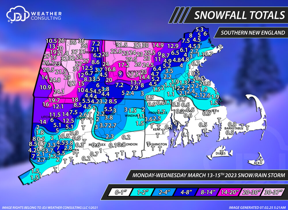
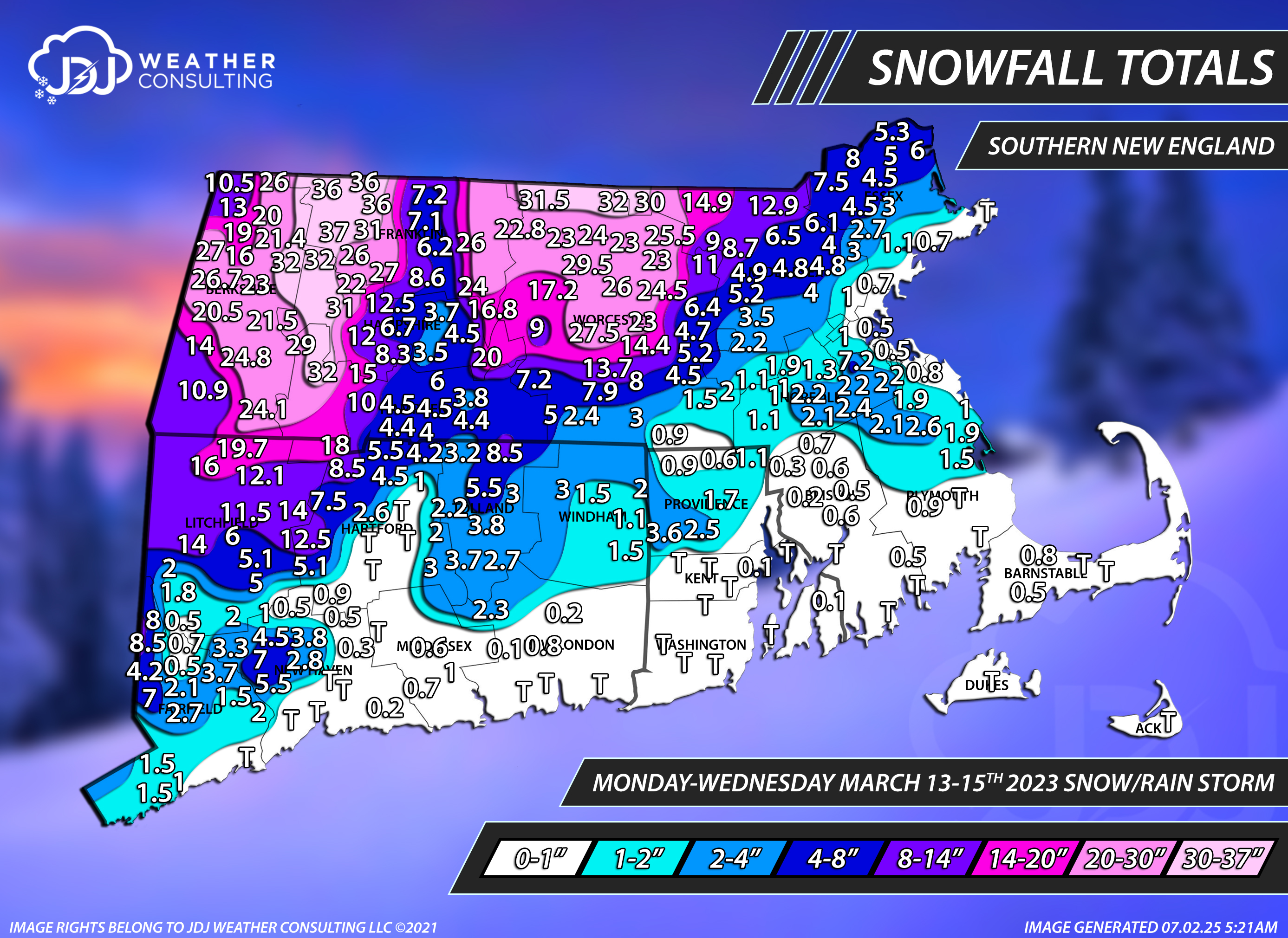
The 4 Seasons replied to Torch Tiger's topic in New England
Yep, Northbridge COOP it seems. I noticed that too I'll keep that in mind, i want to redo all these next year and make them more accurate. Some of the COOP sites drive me crazy they are either suspiciously low all the time or suspiciously high and many of them ALWAYS report in whole numbers which also drives me crazy. Like Thomaston Dam, West Thompson Lake, Mount Carmel in CT are always reporting low and round down...to the nearest integer. Back in the day, especially prior to 2007ish and definitely in the 90s all there was was COOP. Another one is Lawrence, MA COOP it's always been insanely low and whole numbers only, while the Gardner COOP has been on the other end of the spectrum. Care to elaborate? Blue Hill, to me, appears like the snow magnet capital of E MA. They seem to jackpot a lot and do extremely well in marginal situations but it's not like their elevation is 1k+ or something, it's only 635 which im sure helps but not to the extent i see some of these storms and totals they have. Like March 4-6th, 2001, Feb 1-3, 2021 or March 13-15th, 2023 are good examples off the top of my head.