All Activity
- Past hour
-
Crazy Ukmet probably won’t hit its 12z peak but it’s looking good for a solid slam dunk area wide
-

January 25/26 Jimbo Back Surgery Storm
NorthHillsWx replied to Jimbo!'s topic in Southeastern States
Hopefully the euro holds its ground. What we have going for us atm that kinda gives us some wiggle room is a very strong and well placed high (thank the lord). This is the absolute opposite of last weekend, we do not want anything to dig further west and we want very little amplification until the coast. I’m worried by these clown maps with 10” south of 24” luring folks into thinking that is still good. Usually that means as we get closer and resolution increases you can cut those totals by 2/3 south of the max area. Not trying to be negative but we need to be reasonable that a lot of the current data points would indicate south of VA is unlikely to see a pure snowstorm at this time. That does not mean it cannot be a big storm in these areas and I’m not even throwing amounts out but that’s my first call. -
Incoming on UK!
-
GEFS cave
- 740 replies
-
- 10
-

-
GEFS is Huge Totals
-
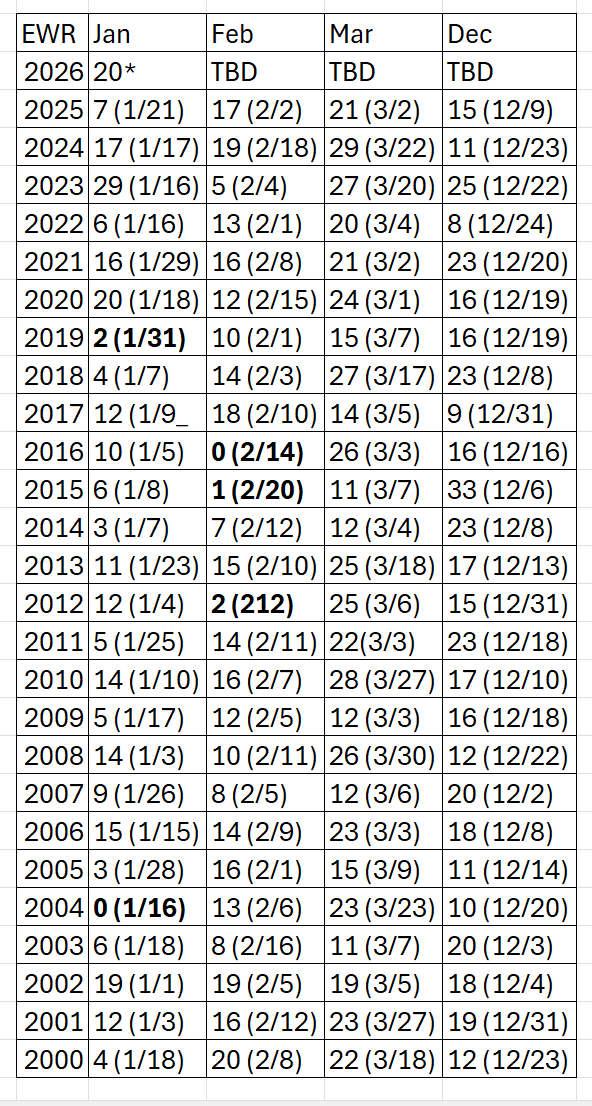
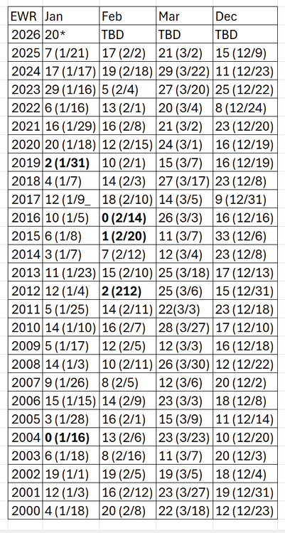
Recent coldest at EWR last 25 years: Bolded 5 and below
-
Time for your nap
-

January 25/26 Jimbo Back Surgery Storm
Thrasher Fan replied to Jimbo!'s topic in Southeastern States
Like a Cat 2+ hurricane. Haha -
00z GEFS is going to be an insane mean, seems to be running a tad colder, more moisture and totals are bumping up even more than 18z. Going to be amazing for many.
-

Possible Record Breaking Cold + Snow 1/25 - 1/26
SnowGoose69 replied to TriPol's topic in New York City Metro
The CMC is phasing/turning the corner in a climatologically very rare location. I have seen some systems do that but they are often monster deep Miller A lows. I think in the end that idea would result in a phase either earlier and more west or more likely east near the SC/GA coast or GA coastline -

Pittsburgh/Western PA WINTER ‘25/‘26
Ecanem replied to Burghblizz's topic in Upstate New York/Pennsylvania
Big storms shift north. Isn’t that what we always say. I want it to be south of us -
GEFS incredibly amped up
-
Gefs going to be a big jump north
-
So it was 9:1 10:1 ratio. Odd
-
tomer berg polarwx.com
-
I would rather it stay a bit south and not get the Baja low as involved. The SE Ridge can be a real beyatch... I still think most of NC mixes at some point, even N of 85. Va mostly snow.
-
Its phasing the storm at an unusual point climatologically. Chances are it will either phase and turn the corner quite a bit west of that or more down towards the coast. No question verbatim its solution is unlikely to the T, you'd need to have a much more dynamic phase or deep low.
-
Have it on some magical site cause everywhere I see it is still 18z
-
Mark margarbage will literally hug any model that gives him snow. Icon cfs… he will be all over this
-
January 25/26 Jimbo Back Surgery Storm
Thrasher Fan replied to Jimbo!'s topic in Southeastern States
I'd need to check the thermals to confirm, but yes the sleet would be measured in inches if that run verified in the north metro. -
DC 1.44 QPF on the CMC. I think we can get even more juice than that. Need the NAM runs.
-
@Ji you probably didn’t notice because it was during the dry slot and not much was happening. We didn’t lose much precip to sleet. Maybe it cost us 1”. But it was off and on light sleet for a while. We did lose 6” or so to the dry slot which is why we had about 24” and not the 30”+ further west and north did. And the sleet was a function of the same thing that caused the dry slot so related. I’m certainly not complaining about the 24” we got. It was an awesome storm but remember they had us in the 30”+ zone for a bit but the warm mid levels pushed further NW than expected.
-

Pittsburgh/Western PA WINTER ‘25/‘26
MikeB_01 replied to Burghblizz's topic in Upstate New York/Pennsylvania
Goodness. A fire hose of snow all over PA . -
Oh ok. Was it snizzle. That Happens often in dry slots. I was just off dransesvilke road close to a cemetery lol Here you go https://www.pro-football-reference.com/boxscores/199601070dal.htm
-
AI-GFS shifted south