brooklynwx99
-
Posts
6,215 -
Joined
-
Last visited
Content Type
Profiles
Blogs
Forums
American Weather
Media Demo
Store
Gallery
Everything posted by brooklynwx99
-

2025-2026 ENSO
brooklynwx99 replied to 40/70 Benchmark's topic in Weather Forecasting and Discussion
can you post some ensembles to back up your point? or just anything, really -
2025-2026 ENSO
brooklynwx99 replied to 40/70 Benchmark's topic in Weather Forecasting and Discussion
this is a pretty obvious P8 signal. there is very little, if any forcing showing up on the EPS over the Maritime Continent
-
the PV closer to us has been perturbed already. seems like this should couple pretty well
-
2025-2026 ENSO
brooklynwx99 replied to 40/70 Benchmark's topic in Weather Forecasting and Discussion
honest question, why are you even on twitter? I avoid twitter like the plague there are enough knowledgeable people here -
2025-2026 ENSO
brooklynwx99 replied to 40/70 Benchmark's topic in Weather Forecasting and Discussion
the weeklies should not run every day. so stupid -
2025-2026 ENSO
brooklynwx99 replied to 40/70 Benchmark's topic in Weather Forecasting and Discussion
can pretty easily see the N ATL trough feeding back on the Scandi ridge, which then increases heights in the NAO region... this elongates and presses the TPV south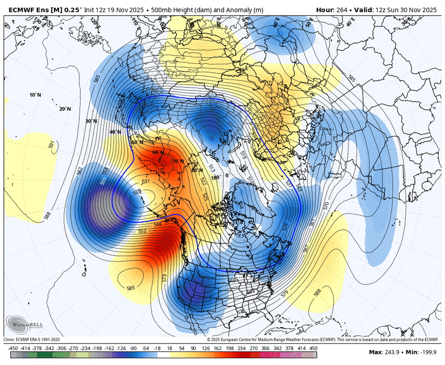
-
2025-2026 ENSO
brooklynwx99 replied to 40/70 Benchmark's topic in Weather Forecasting and Discussion
the EPS is just a day or two slower. it gets to the same point with a -NAO developing thanks to Scandi ridging (which is typical of SSW events) -
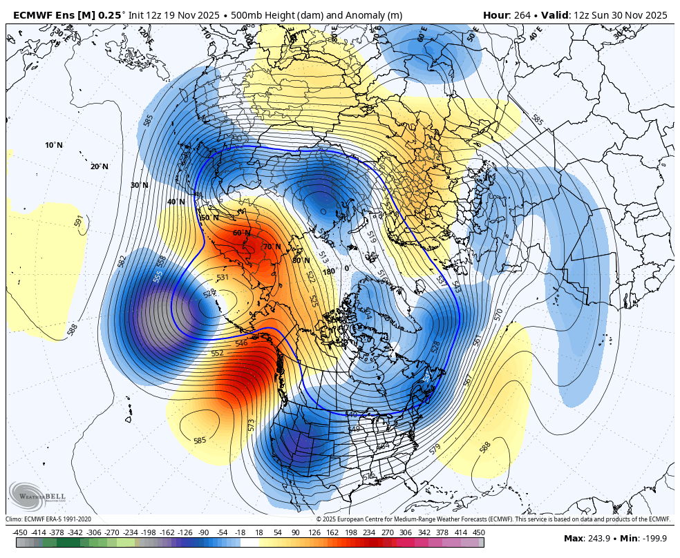
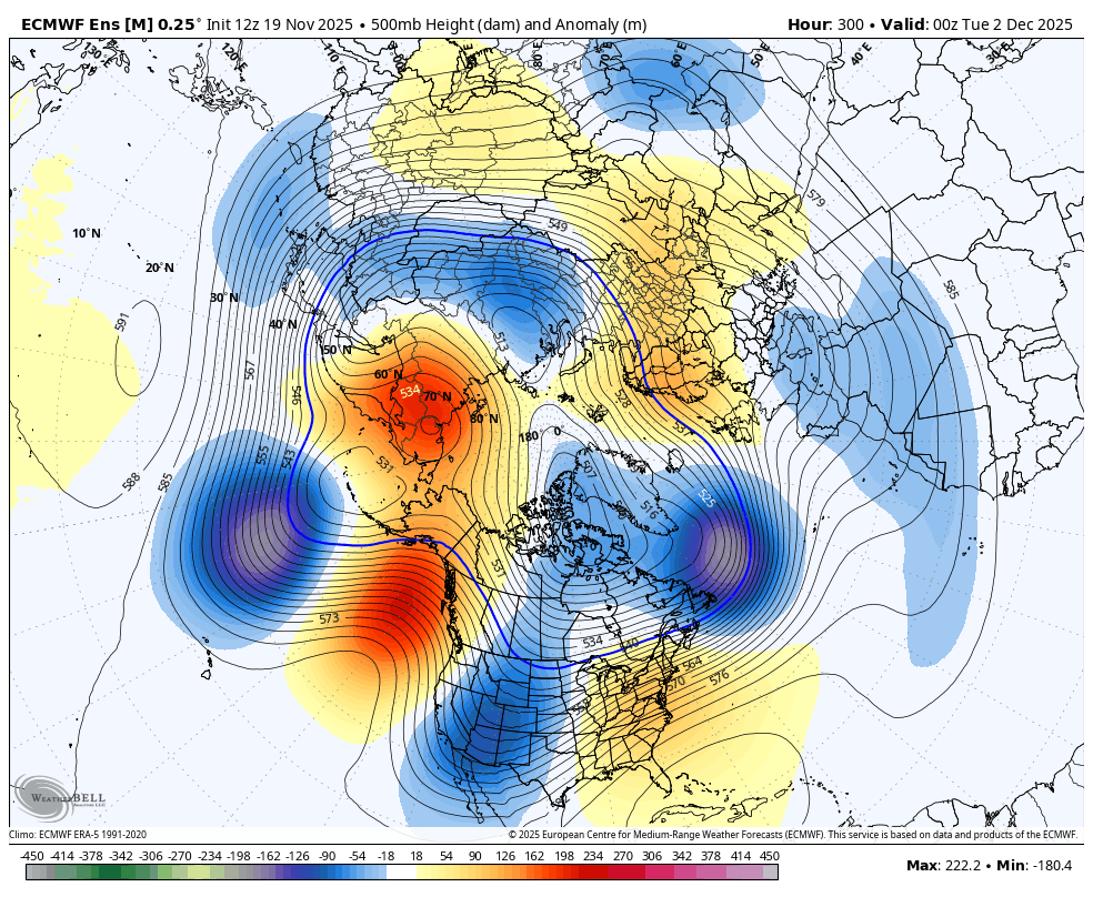
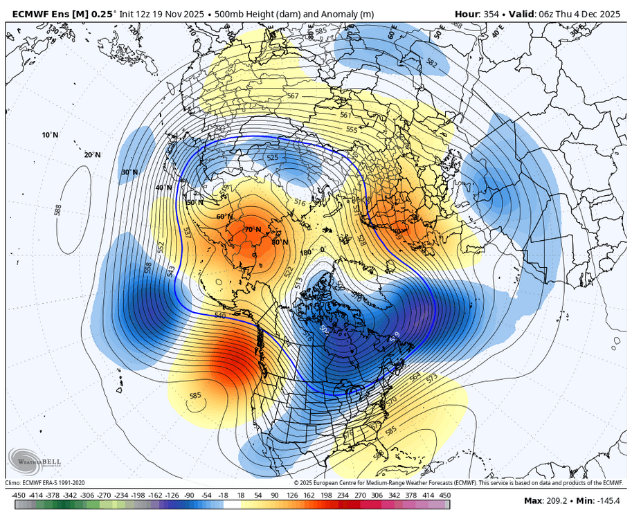
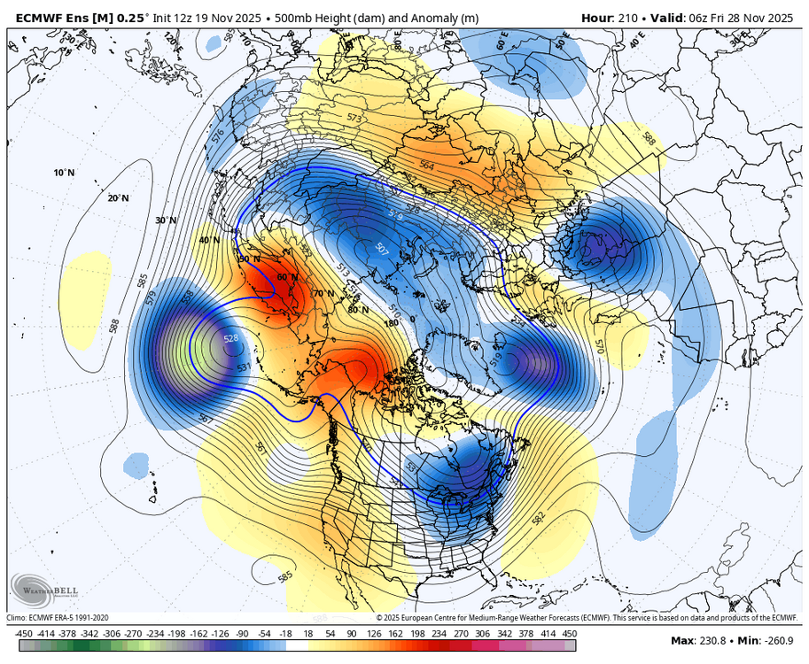
really liking the progression on all the ensembles as we head into the first week of Dec initial equatorward jet extension -> T-day trough establishes cold along with building -EPO/-WPO trough moves into the N ATL and increases Scandi ridging -> second trough dumps cold into the West and Canada second jet extension pushes cold east -> N ATL trough strengthens and starts pushing Scandi ridging into the NAO region


-
really liking the progression on all the ensembles as we head into the first week of Dec initial equatorward jet extension -> T-day trough establishes cold along with building -EPO/-WPO trough moves into the N ATL and increases Scandi ridging -> second trough dumps cold into the West and Canada second jet extension pushes cold east -> N ATL trough strengthens and starts pushing Scandi ridging into the NAO region


-
2025-2026 ENSO
brooklynwx99 replied to 40/70 Benchmark's topic in Weather Forecasting and Discussion
like this is just a fail. the stronger Pacific jet actually helps in Ninas most of the time, not hurts
-
2025-2026 ENSO
brooklynwx99 replied to 40/70 Benchmark's topic in Weather Forecasting and Discussion
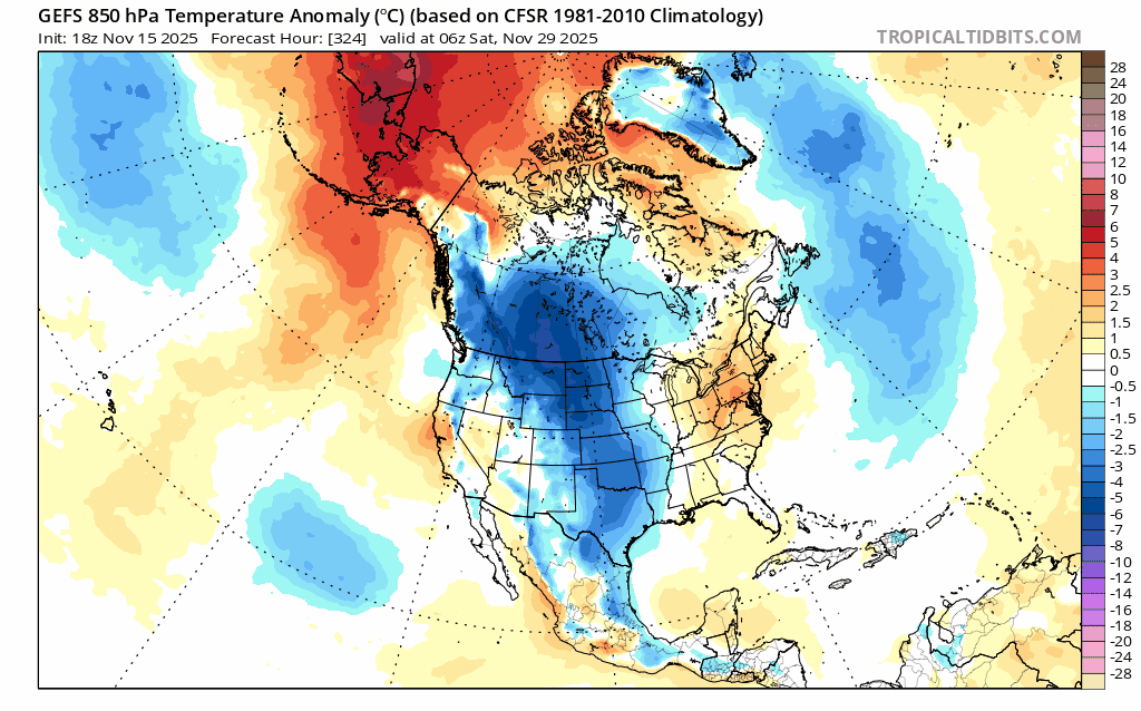
that's transient. models have vastly underdone the cold spell near Thanksgiving already and whatever brief warmup occurs around the start of the month won't last long -
can see heights rising out west at the end as well as the Atlantic pattern becoming blockier
-
2025-2026 ENSO
brooklynwx99 replied to 40/70 Benchmark's topic in Weather Forecasting and Discussion
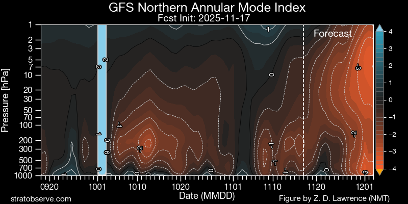
meh. I find that hard to believe given the coupled SSW and MJO progression. should get quite favorable after the 10th, not the other way around -
2025-2026 ENSO
brooklynwx99 replied to 40/70 Benchmark's topic in Weather Forecasting and Discussion
lol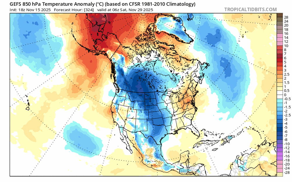
-
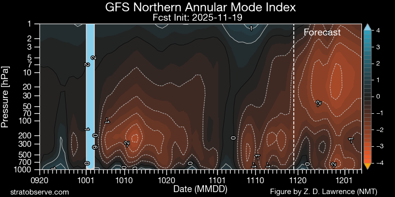
yeah, given how coupled the stratosphere is, I don't think we're on voodoo alert with the nearly certain SSW... we should see an Atlantic blocking spell this month
-
that EPO isn't a waste, though. always good to have Arctic air nearby so you get a quick flip and cold source region
-
my guess is that the pattern becomes better for most after the 5th
-
2025-2026 ENSO
brooklynwx99 replied to 40/70 Benchmark's topic in Weather Forecasting and Discussion
whatever you say -
2025-2026 ENSO
brooklynwx99 replied to 40/70 Benchmark's topic in Weather Forecasting and Discussion
also, anything before Dec 10 is gravy for 80% of NE/MA posters on this board. couldn't care less if it takes a few more days to get things going -
2025-2026 ENSO
brooklynwx99 replied to 40/70 Benchmark's topic in Weather Forecasting and Discussion
models often rush the progression of cold air eastward in -EPO patterns. i would say after the 5th is when snow risks increase for many in the Northeast in the same vein, i don't think much has really changed in terms of the overall progression. MJO is moving along, the SPV will become very weak and increase the shot at a -NAO spell, and we should see a BN to solidly BN December also, when you have a -WPO/-EPO (and likely a -NAO at some point), it is really, really difficult to have a truly bad period since there's so much cold air displaced into Canada and the CONUS -
2025-2026 ENSO
brooklynwx99 replied to 40/70 Benchmark's topic in Weather Forecasting and Discussion
I’m pretty sure the GEFS has a strong/cold bias with the SPV, but i could be wrong -

-
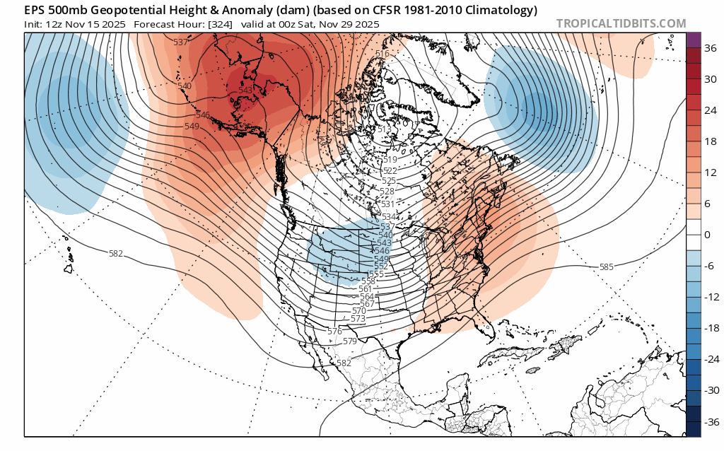
pretty significant -EPO is likely with the Pacific jet retracting and then breaking equatorward. that's going to have some staying power and will be able to tap into true Arctic air

-
2025-2026 ENSO
brooklynwx99 replied to 40/70 Benchmark's topic in Weather Forecasting and Discussion
ensembles are growing more and more aggressive with the -EPO around Thanksgiving thanks to the equatorward movement of the Pacific jet. high confidence in this occurring given the lead time