MillvilleWx
-
Posts
5,530 -
Joined
-
Last visited
Content Type
Profiles
Blogs
Forums
American Weather
Media Demo
Store
Gallery
Everything posted by MillvilleWx
-
This setup is reminding me of a few moderate events we've had in these parts back in the 2010's. Most famous was the December storm that crushed the area and gave the Ravens snow game vs Minnesota. Snow came in like a wall, which is what the GFS is advertising now in successive runs. Quick storm, but a nice thump from a decent WAA regime.
-
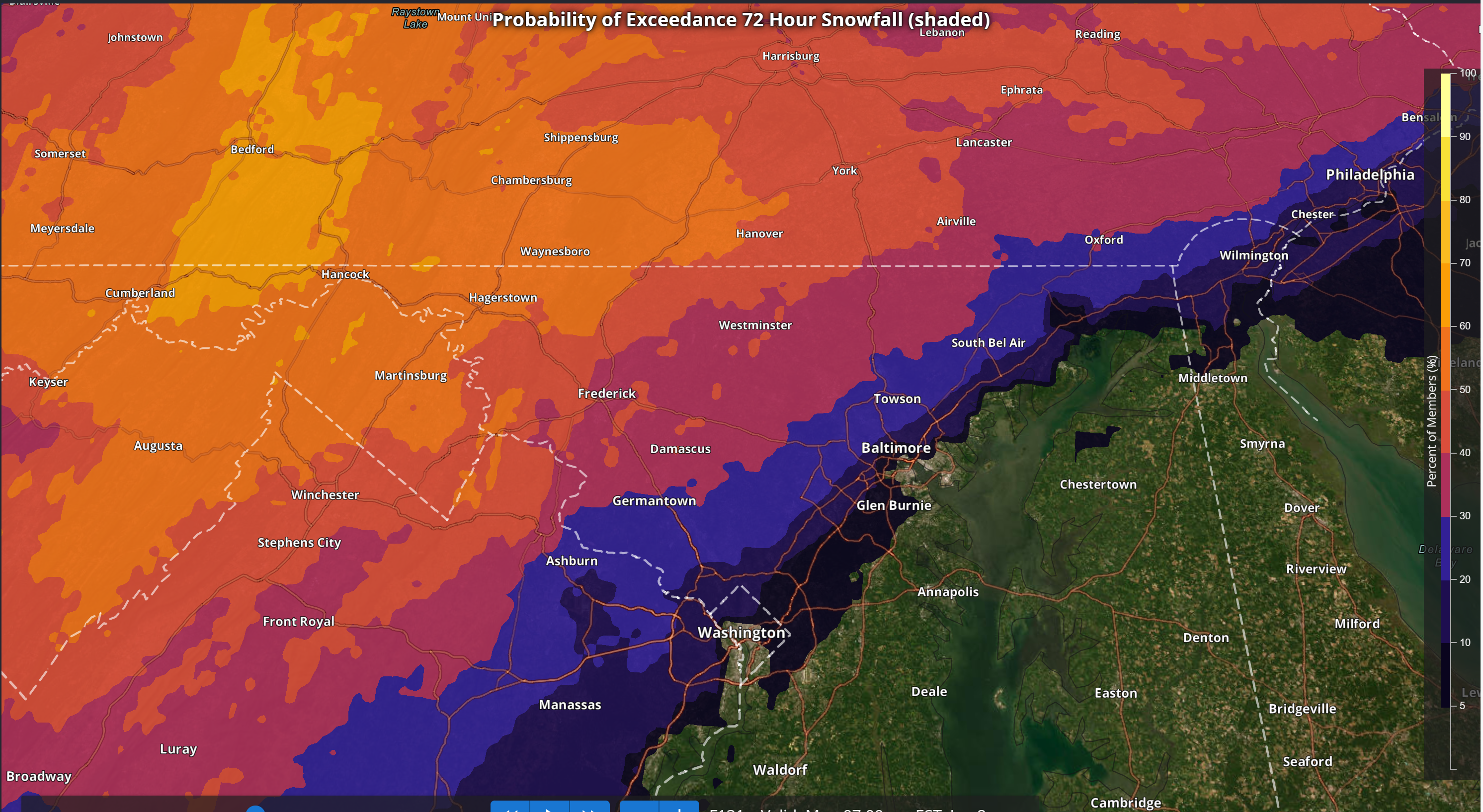
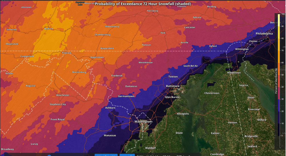
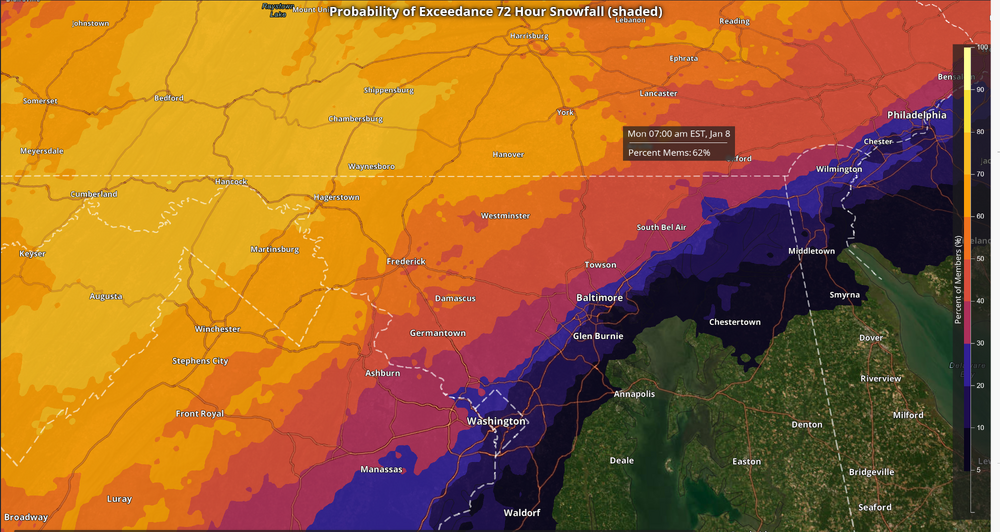
Latest NBM Probabilities >= 3" >= 5" Not bad considering the time before the actual storm
-
Your area is gorgeous. I was on a hike in those parts last month. Should be a nice little storm up there!
-
Looks like a slight tick down and actually the biggest loss north of the Mason Dixon where 1-2" was lost over the highlands. We'll see this bounce a little bit in the coming days, but this is still a decent event to get the ball rolling. Yes, it stinks not getting a bomb, but having snowfall during the day and evening on Saturday will bring up everyone's spirit. I'm staying positive because this will be my first good event since moving back home. It'll be special to me
-
Life in the valley! I live on a hill off Monocacy, but I still won't get as much as places along the Catoctins to the west of Thurmont. Still a nice event out in these parts. Thanks! I was gonna start looking myself, so I appreciate the aid on posting the maps
-
This was definitely expected with the latest data at 12z, but definitely not the end of the world. It's a solid first event, verbatim. One of the characteristics I like about the NBM is being able to depict elevation and outlining the areas of focus climo wise. We haven't even gotten into hi-res territory yet where there will be more definition inside 48 hrs and even more inside 24 hrs. A textbook fall line scenario right there. 3-6" with local to 8" is a good call for areas NW of the fall line with 1-3" max to 4" along and southeast. I'd take this in a heartbeat. Thanks for that update @mappy
-
If they did, I would have to stop using them and then I would be sad Fortunately no!
-
Funny you mention that because that’s pretty much what the GFS did and is a great way for many to score in this setup. Simplicity is best. A wall of moisture running into cold air with decent mid-level ascent focused over the central Mid Atlantic. These are some of our favorite type of events. They come in hot and slam for 8-12 hrs then scoot out. Typical caveats aside with the fall line and southeast being prone to changing over, but it would offer the opportunity for a period of heavy snowfall before any potential flip. Just one of the possible outcomes in this setup.
-
I’m sure my wife would be very happy to know that
-
I’m always looking for the Brazilian model to base my entire forecast on
-
I need to go to Spain so bad. I know someone who lives in Barcelona and they said they would house us if we came over. Might have to take advantage of that!!
-
That ECMWF site is probably the best right now for public use. I’m sure there are others, but some are behind secure networks that you need authorization for. We are in testing mode for a lot of these and one of the cool parts of graduate studies is there is more emphasis on AI for use in operational settings. I can see them being incredible helpful in 5-10 years.
-
It’s wild. And parsing ICON data is wild to me. That model is terrible.
-
Where that line ends up for the R/S designation, anyone NW of that has a great chance to see high end advisory to low/middle end warning criteria snow. This system will be bringing the juice. Will come down to thermals
-
Yes we have! They are helpful with forecasting in the medium range and are gaining steam on being an integral piece in decision making at leads. ECMWF has a great set of AI tools we utilize.
-
We know the drill in these setups. Temper expectations, but globals are not going to get the CAD right at any point, especially at leads. I’m looking forward to dissecting the Nest, HREF, and HREF probabilities for everything. Climo wise, you’re in a great spot.
-
Guys, I’m not saying to discount the ICON, but there’s a reason we don’t include it in our verification stats for deterministic at the National Center. It’s like the NAM of the globals.
-
If there is one thing our area we live in does well and it’s that. CAD is a beast to erode in the valley. It’s why the US15 on west corridor is mentioned so often for staying most or all frozen in these events.
-
JI Melts is basically a free square. Almost cheating
-
Man. I just read everything and I would’ve thought everything went to rain. Looked at guidance and the blends and… we really are mentally in a horrid spot in this subforum after the last several years. 13z NBM this morning looks great for those NW of the fall line. Idk how many times I have to say this for this setup; historical precedence for setups with in-situ CAD with non-Arctic air masses tends to favor those NW of the metros with a changeover much more likely for areas southeast of that geographical marker. NBM is a large assortment of guidance with tons of LAMP, GFS/EC/CMC deterministic and ensemble members, and other guidance that has weighted means to aid in the forecast. Is it perfect?, No! Is it statistically significant and helpful in forecasting at leads greater than 3 days?, you bet. Not saying we’re all going to be singing kumbaya. I’m saying to temper expectations at leads. We are still in ensemble land. We haven’t even seen some of the better short range guidance that handle thermals better as we close in. Deterministic gets these wrong all the time. Large scale features need to be monitored. I’m not basing any forecast on the global deterministic handling of any PBL thermals. Now on to 12z…
-
Too early now, but later this week I’ll drum one up so long as things look solid!
-
Thanks! It feels great to be back on the east coast and I get to actually track something for my back yard again I think the trends right now are positive for the LSV and south-central PA area. I would imagine the favorable spots along the Mason Dixon up to the turnpike are in a good area for the time being. Too early to talk totals, but the key will be the storm not going too far south and the confluence to the north doesn’t thwart latitude gain. Analogs right now are pretty solid for the region, so I like where you guys sit at this point. I’ll come by and add some insight as we approach. Perhaps a snow map is in order!! Been awhile since I did one for the subforum.
-
Howdy everyone
-

Jan Medium/Long Range Disco: Winter is coming
MillvilleWx replied to stormtracker's topic in Mid Atlantic
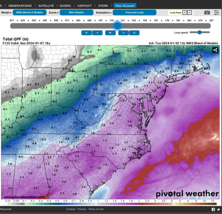
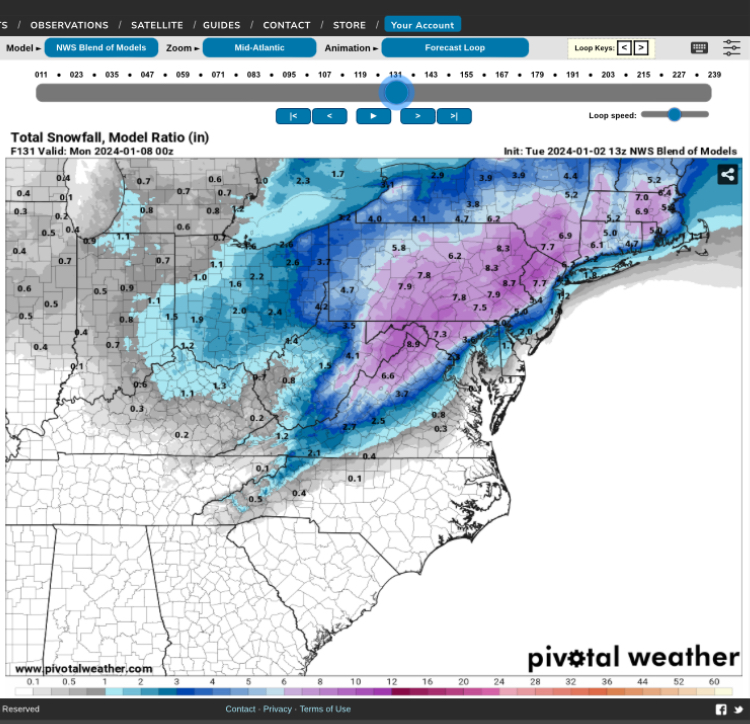
NBM continues to be impressive at leads with the mean QPF and snowfall forecast. Odds are increasing of 1-1.5” QPF during the time frame of the storm, so you can deduce some average ratios of 7-8:1 to as high as 12-14:1 during the storm height within any banding. A pretty good indication of 6-10+” is on the table if all things break correctly. In-situ cold will be great leading in with drier dew points. That should aid in wet bulbing on the initial surge of low-mid level moisture that’s accustomed to these events. Good trends overall. -
Jan Medium/Long Range Disco: Winter is coming
MillvilleWx replied to stormtracker's topic in Mid Atlantic
Good seeing you in the sub Andy! Hope all is well down in Norman. If you ever want to take the NWS route, feel free to reach out. Hopefully the southern stream can give you guys some fun later this month through winter.