MillvilleWx
-
Posts
5,543 -
Joined
-
Last visited
Content Type
Profiles
Blogs
Forums
American Weather
Media Demo
Store
Gallery
Everything posted by MillvilleWx
-
Have you tried better grips on your shoes?
-
I told my dad we finally got a small gift from the refs. That now brings us up to about 91 small gifts short compared to all the other teams have gotten against us the last 20 years.
-
Was 56° at 515PM at my apartment. Left at 615 to 51° and bottomed at 50° on my drive in to work. 54-56° around College Park. Expecting flakes to fall but not much accum in my hood, although an inch possible on elevated and grassy surfaces. Just nice to know flakes will be flying on my drive home from work
-
Currently battling a bout of strep throat at the moment, so I’ve been out of it. Biggest story will be the abundance of moisture with the system which will help get some much needed water into the region to curb the drought. Not a bad thing heading into winter. As for snow, system is very dynamic, but will come down to the low-mid lvl CAA regime as the storm matures and rolls into occlusion phase. I don’t buy the crazy totals the NAM is implying, but there’s a decent chance many of us see some flakes this go around with light accumulations possible across areas along and north of I-70. Details can change over time, but this isn’t a textbook moderate snowfall for our area, but it’s one where people can get on the board. Idk if I’ll ever have any forecast for this one, so I’ll follow along and chime in when I can. Strep sucks. That is all
-
This seems to be the MO the past 2 decades outside a couple crazy good years. I basically expected nothing in December, so I’m not too disappointed…yet
-
First day of Met winter was less than a week ago and we have 6 pages of the Panic Room. Never change y’all
-
BWI: - 19.3” DCA : - 15.8” IAD: - 23.5” RIC: - 6.8” Tie breaker SBY: - 8.2”
-
Happy Thanksgiving everyone! May the day be filled with joy, family, friends, and football
- 357 replies
-
- 11
-

-
Wow! Incredible system for the FDK area. Man did we need this rain!
-
A well forecast shallacking back at Mi casa in North Frederick. 2.69” for the event. It was dumping buckets for hours between 6 and when I went to bed at 9pm. Judging by radar, it went on for a couple more hours. The region needed this one. Love to see it!
-
To me, this is hands down the most important aspect of the whole forecast for winter. As long as that STJ stays active and brings precip into the area, we will have multiple chances. I’m not expecting a blockbuster winter here (Foreshadow for my snowfall contest prediction later this week), but I expect several chances at precip and timing cold will be key. As of now, I am encouraged with what I see. No, I’m not through the moon, I am cautiously optimistic. It is mid to late November… a lot of season ahead, including peak winter which for us isn’t for another 1.5 months. Patience is a virtue everyone. Enjoy the holidays and keep an eye on short term threats, but I wouldn’t even start tracking long range for another month yet imho. Keep the faith guys!
- 1,295 replies
-
- 19
-
-

-
- wishcasting
- almost winter
- (and 1 more)
-
Big W tonight, but it wasn’t without a big blow. Andrews done for season. Next man up! Need the WR room to step up, as well as Likely and Kollar. Likely has shown flashes, but he’s also shown he can get lost out there. Need him to step into the role.
-
One thing I miss about Texas is the BBQ, Jeb. Man, they can make some killer brisket and BBQ in general down in those parts. Holy cow, literally
-
Got a chance to meet and hang out with @WxWatcher007 this evening and it was a blast. I certainly want to meet more in here in the future. Tonight was so great! PS: If you've never been to El Sapo in Silver Spring, you have to go! Authentic Cuban cuisine that will knock your taste buds out. Outstanding
- 357 replies
-
- 11
-
-
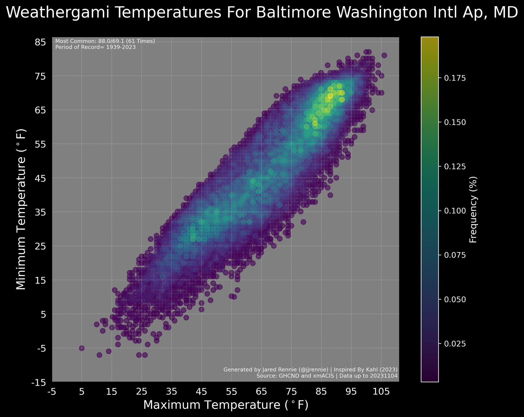
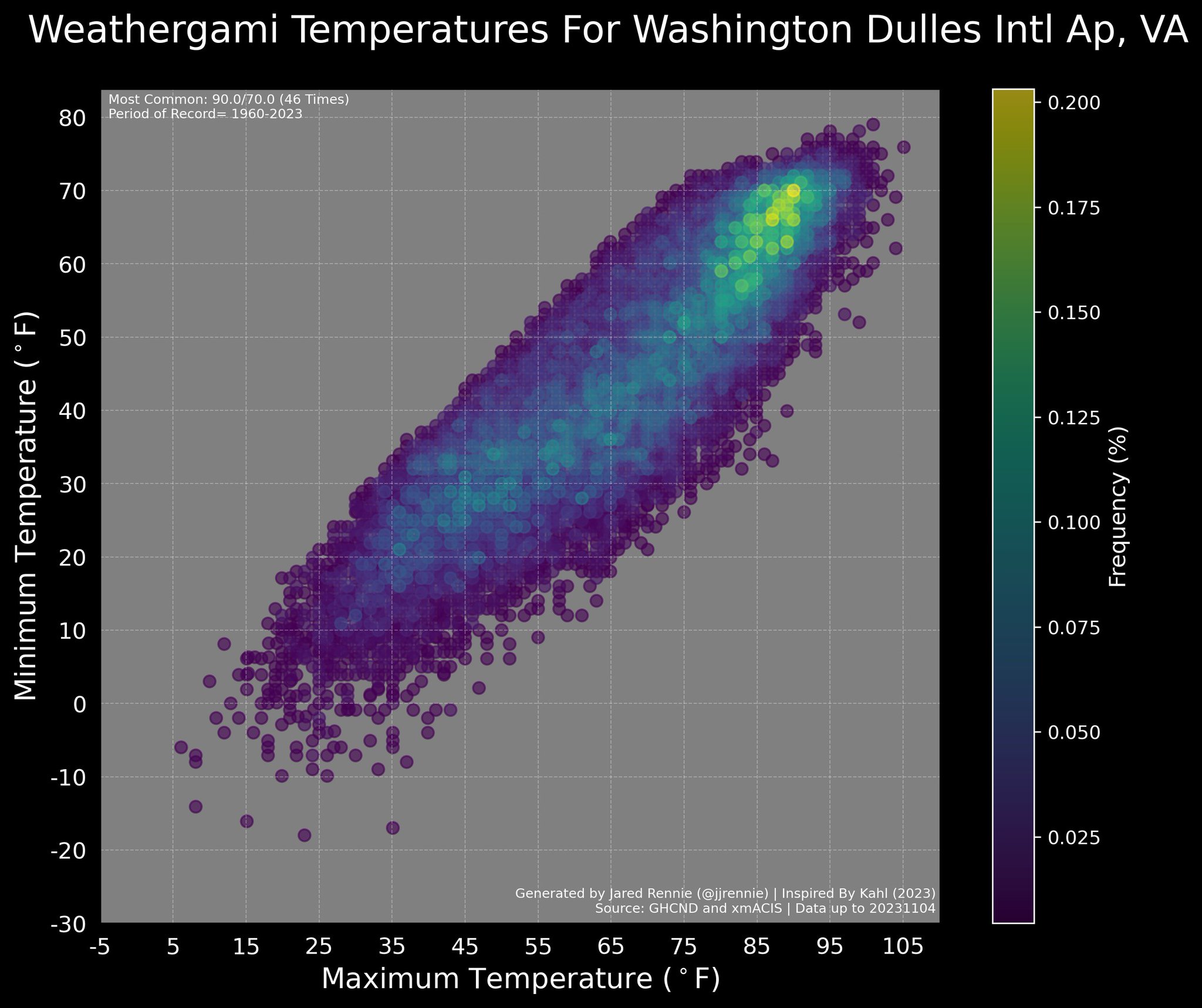
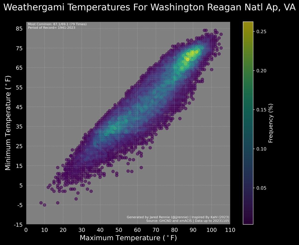
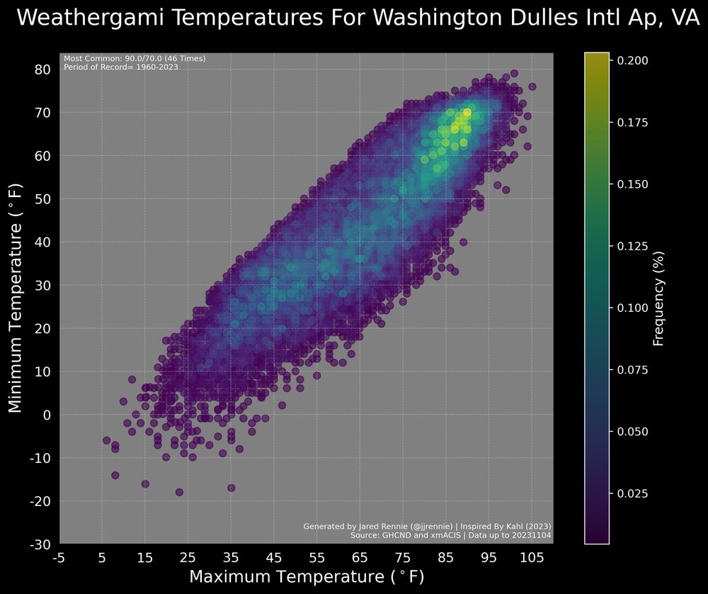
Pretty cool data here. Graphic showing the frequency of certain high/low patterns. Jared Rennie is a great source for cool climate and weather info. Give him a follow! IAD/BWI/DCA Temps

-
Low of 27° this morning in north Frederick. First hard freeze of the season.
-
So close to the 30s with 40° for the low. It did get to the 30s in the lower elevation spots to my north. It was 43° when I left for work, but it fell further prior to sunrise. Great start to the day. Happy Halloween everyone!
-
You can always make a revised version in a month after new data. No one would fault you for it. I for one appreciate new insight after seeing the new data. Textbook long range forecasting.
- 1,295 replies
-
- 5
-
-
- wishcasting
- almost winter
- (and 1 more)
-
Truth. I was enjoying the fall weather before this crap moved in.
-
I just like seeing a continuation of coastal development along the east coast. I’m not expecting anything significant for a while, but with persistent troughing east of the Mississippi showing up on ensembles we could sneak something. Still so early climo wise. I won’t get excited until it’s basically on the doorstep.
- 1,295 replies
-
- 6
-
-
- wishcasting
- almost winter
- (and 1 more)
-
Hi of 83° after a low of 54° Really looking forward to this cold front!
-
Went to Denizen’s after work yesterday in Hyattsville. Had a few seasonal cocktails, but their beer menu was pretty jam packed with good stuff you’d approve of. Food was solid too. If you’re ever in the beltway area, highly recommend.
-
Beautiful morning today. Everyone make a it a great one!
-
Don’t get my hopes up
-
What a series of microclimates near me. Low was around 47° on top of the hill I live on. There is a community kind of tucked into a little valley less than 1 mile from me that hit 40°. Impressive Another warm one today. Actually gorgeous for a nice afternoon walk.