MillvilleWx
-
Posts
5,543 -
Joined
-
Last visited
Content Type
Profiles
Blogs
Forums
American Weather
Media Demo
Store
Gallery
Everything posted by MillvilleWx
-
This front in W TX is no joke. We are down 10 degrees in 8 min. Already in the low-20s, well ahead of schedule. Upwind temps in the low-teens already. Get ready!
-

December 22-23, 2022: Warm Rain to Arctic Chill
MillvilleWx replied to WxUSAF's topic in Mid Atlantic
I'll have some thoughts on the snow potential for Friday AM sometime later today. At work this AM and busy contending with the arctic blast we'll be getting down this way. Looks like temps falling through the day tomorrow with a low between 5-8F on Friday morning. Brrrr -
Central PA Winter 2022/2023
MillvilleWx replied to Blizzard of 93's topic in Upstate New York/Pennsylvania
Can confirm There is a masterful burger joint there though, so it's like 1.5 stars -
Just a quick check-in before bed. I mentioned yesterday there will be multiple ways to obtain snowfall for the region in this pattern. Even a cutter with a massive arctic front would likely produce snow squalls and whiten the place up for the holidays. Big storms need everything to go right. That’s obviously still on the table, but probalistically that’s not the most viable solution. GFS was a solid compromise this evening. Also, keep an eye on that initial SLP ahead of the digging 5H trough. That’s a way to squeeze an advisory level snow out before even looking at the main show everyone is hoping. Solid look on guidance this evening. Still 7+ days away. A lot of time and I doubt we’ve seen the real solution at any point.
-
Euro would be deep winter for Christmas if that panned out. Hell, I'd take that at face and enjoy my holiday if it worked out like that. The trend is more amplification at 5H, and if you want a good storm, that's the way to go. One of the positive scenarios with these evolutions is the fact you would see snow regardless if there is a coastal or not just from the robust Arctic front that would blow through. A lot of positive takeaways in the 12z suite.
-
Definitely one of the best teams to bet on for the NFL this year. They have won 1H moneyline all but 2 games this season as well. They have covered the 1H spread over 70% of the time as well. Kind of remarkable. The craziest stat of them all I know was if you teased the opponent of the Rams by 6 points on the final spread, you would be undefeated this season. That is absolutely incredible.
-
I'm sure Manchester is glazed like a donut at this point. Haven't heard much from our friends up there.
-
Awesome. I've been sports gambling for the past 10 months. It's a challenge, but can be a lot of fun. If I was back home, I'd be deep into it. I love betting props and lines. Thanks mappy! Didn't want to bring up a subject that should be referenced elsewhere. And don't worry, no fights from me. I was just seeing if anyone was interested!
-
Dude. This is repulsive. I'll have you know I hit my arm on the side of the door frame a few weeks ago, and I only cried for 5 minutes.
-
Mrs. J, please don't ram into the store. They have automatic doors these days
-
Also, this is a question for mods and owners @mappy @WxUSAF @stormtracker Is it taboo to talk about any type of gambling in the banter threads, or should that be taken elsewhere? I just wanted to know if anyone here has participated in anything since MD introduced Online sports betting last month. I'll move any conversations if necessary, but wanted to check! Thanks in advance. Hope you all are doing well
-
I hope this winter yields at least 2 to 3 storms that I can track with everyone here and get in the snow forecasting spirit. The way things are shaping up the end of the month are very promising for at least some snow squall potential with a powerful Arctic front. The best part about all this is it's still December. Our prime months are around the corner. Even a little snow will make things festive and ready for the holidays
-
I'm glad I still know what I'm doing
-
Thanks Matt! I think it'll be interesting to see if the temps can bust a degree or two low. That's going to be important with this setup since every degree counts in marginal icing events. I think if clouds can stream in prior to 1pm, it could certainly play a role in limiting diurnal heating and keep the temps slightly lower than forecast. As far as the overnight start time, this would certainly have a benefit for some, mainly east of the fall line because after sunrise, it's pretty much a given that we'll see sufficient mixing to erode any weak CAD signature hanging around. I think spots down by Harrisonburg/RNK are in a better icing setup due to the majority of precip occurring with a lack of solar insulation.
-
Currently have a bit of a separation of camps setting up between the globals and the hi-res due to the obvious resolution concerns that crop up in the short range. In the short range, it's important to follow the trends in dew point obs and temps, as well as cloud cover advancement and increasing SE flow as the low begins to develop early tomorrow morning. The current setup is indicative for a period of icing for all areas, including east of the fall line, but I have my doubts the impact will be too substantial for the DC/Balt urban areas as temps will be borderline, at best for prime ice accretion. To the west of the fall line, there will be an extended period of icing that starts early AM and last until close to Noon for locations above 600' elevation and even longer for places out by I-81 where the warm nose will take more time to protrude deep in the boundary layer and warm up enough to switch from ZR to rain. Here are two pieces of guidance I like for the current indications of potential. Note, NBM is blended guidance and will not handle CAD as well compared to higher res solutions, thus the numbers a bit degraded compared to where they may end up. One of the trends I noticed on looking at models this AM is a period where the temps will warm slightly before falling due to evaporative cooling processes as the precip becomes "heavier". This is a solution that has merit, but I wonder if this will limit any ice potential for areas along I-95 and east. Highest impact will be the valleys west of Frederick up to South Mountain and the Catoctins. Also, the I-81 corridor from Winchester down to Luray will be a mess as the warm air will struggle to mix to the surface and temps hold between 30-32F for an extended period. Current thinking is the WWA/WSW are in the right places given the recent guidance and trends in the short term. KOKX around 0.25" of ice is certainly in the cards. 0.25-0.5" out by Hancock and along the ridges in Western MD. T-0.05" along I-95 and inside the beltways. 0.05-0.15" for areas along and west of the fall line. Catoctins will likely be WSW criteria, but because it falls in Frederick Co, they will remain a WWA due to the population center away from the mountains.
- 596 replies
-
- 18
-

-

-
I collapsed and blacked out at 5am last Tuesday trying to go the bathroom. Checked my vitals on a PulseOx; O2 was 97% and Heart Rate was 47.....
-
Almost fully recovered from my first bout with Covid. 0/10 don't recommend Good news is Paxlovid is amazing if you can take it while having Covid. The headaches and fatigue were brutal. The cinderblock feeling in the chest also was not appreciated. And trying to mess with my blood glucose levels being diabetic. Overall, dissatisfied customer. Will be speaking with the manager....
-
This storm is a classic case of CAD with the fall line and west the primary beneficiary of any winter precip. Judging by initial thermals off guidance, the storm will start as some snow out by I-81 and MAYBE a short period in the beginning for places along and west of the fall line. 925/850mb winds increase out of the SE during the 12-15z time frame, likely when we see the advection of warm air within the boundary layer that's pivotal to ptype. At the surface, the wedge of cold air will be tough to erode west of the BR with 30-35F likely to hold through a majority of Thursday. NBM 25th percentile shows places like Winchester/MBG/Cumberland hanging tight around 31-33F for an extended period of time with a textbook ZR signature on soundings from deterministic models. A light icing event is probably best suited for places east of US15 with more ice located west of the US15 divide, especially in valleys where cold air will take longest to scour out. Currently looks like a high-end Advisory event for I-81 and west with some WSW potential if the CAD signature shows more staying power. The 925-700mb is getting torched no matter what, so don't feel disgruntled if you see the snow chances eroded with mainly ZR/IP as the primary ptypes during the event. The metros should see very little icing, but a light glaze prior to 9am is possible before we see temps mix efficiently above 32F as SE flow ramps up the second half of the morning, through the rest of the day. Obviously if cold trends point to a colder start, then everyone could see Advisory level icing with warnings out by I-81 and the eastern WV hill country. We've seen that before, but as @WxUSAF mentioned, cold air within the BL gets eroded faster than normal. Especially early season where local water temps are hovering in the 50s.
- 596 replies
-
- 17
-
-
-
You just want to go to Dogfish Head Brewery in the snow again, don't you Squidward?
-
Final Guess Here. Upped a few totals. Hope I bust low BWI: 15.5" DCA: 12.2" IAD: 18.3" RIC: 5.5" Tiebreaker (SBY): 10.8"
-
I am intrigued by this 5H evolution down the pike. Might have to wander out of hibernation
-
Historic Lake Effect Event?! 11/17-11/21
MillvilleWx replied to BuffaloWeather's topic in Upstate New York/Pennsylvania


-
Historic Lake Effect Event?! 11/17-11/21
MillvilleWx replied to BuffaloWeather's topic in Upstate New York/Pennsylvania
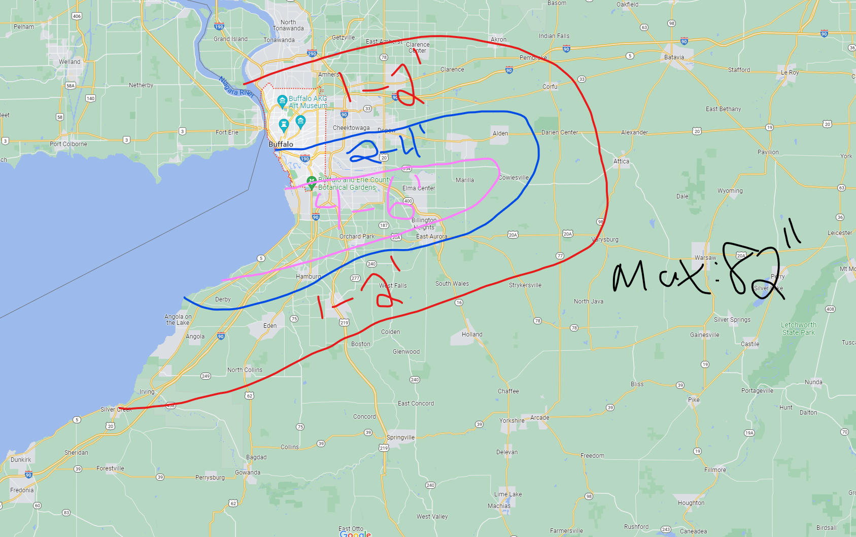
Just a smidge too north. Otherwise, heart of this is looking good. Might have low balled…
-
Historic Lake Effect Event?! 11/17-11/21
MillvilleWx replied to BuffaloWeather's topic in Upstate New York/Pennsylvania
Heck yeah we do! I wish I was up there for this one my man. We want to travel next year, so we may be up in your neck of the woods. I’ll hit you up! Enjoy the mountains of snow -
Historic Lake Effect Event?! 11/17-11/21
MillvilleWx replied to BuffaloWeather's topic in Upstate New York/Pennsylvania
Could be a little too south given the flow. Again, pretty quick forecast. May adjust about 20-25 miles north either side.