MillvilleWx
-
Posts
5,530 -
Joined
-
Last visited
Content Type
Profiles
Blogs
Forums
American Weather
Media Demo
Store
Gallery
Everything posted by MillvilleWx
-

The Weekend Rule? Saturday 2/17 - The Icon Storm
MillvilleWx replied to DDweatherman's topic in Mid Atlantic
I'll try to fine tune this forecast with the new 12z data set. Might be bumping totals a bit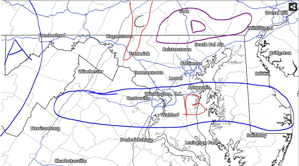
-
The Weekend Rule? Saturday 2/17 - The Icon Storm
MillvilleWx replied to DDweatherman's topic in Mid Atlantic
Colleague and I were just talking about this. Pivotal utilizes the surface as part of the formula for ratios on Kuchera and it's weighted too heavily. If it started off the surface from 925 and up, it would be much much better. The Kuchera ratios are better on WeatherBell, but still might be a touch high. -
The Weekend Rule? Saturday 2/17 - The Icon Storm
MillvilleWx replied to DDweatherman's topic in Mid Atlantic
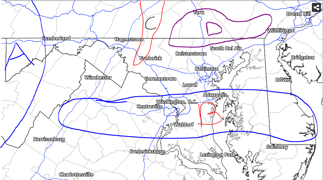
Rough snow forecast outline (Medium Confidence): Zone A: 6-10" Zone B: 3-5" w/ stripe of 5-6" within the 85H frontogen band that sets up from NoVA through SoMD. The potential does include the DC metro, but best chance for highest totals will lie on the edge and outside the beltway. Uncertainty for Southern DE due to thermals Zone C: 4-6" in the Catoctins and adjacent terrain Zone D: 4-6" w/ max of 7" elevation areas above 650ft. This is tricky depending on 7H frontogenesis placement Most of region: 2-5" fairly widespread. Higher totals within the Parrs ridge area from NW MoCo through western HoCo into the Carroll/Frederick border (Clarksburg/Damascus/Mount Airy). 1-2" for areas south of Zone B
-
The Weekend Rule? Saturday 2/17 - The Icon Storm
MillvilleWx replied to DDweatherman's topic in Mid Atlantic
Was this the same storm someone said they didn't believe you had two inches of snow, so you took a picture with a newspaper with the date on it in the background of the ruler in the snow and a thumbs up? One of my favorite things I've ever seen on this forum. -
The Weekend Rule? Saturday 2/17 - The Icon Storm
MillvilleWx replied to DDweatherman's topic in Mid Atlantic
That's pretty specific for Frederick -
The Weekend Rule? Saturday 2/17 - The Icon Storm
MillvilleWx replied to DDweatherman's topic in Mid Atlantic
This is a fun little event coming up. 2-4" of snow for areas north of Rt 50 is a good look imo. Good timing too. Later Friday into Saturday. Some night time snow heading into a weekend. Good time to break out a good drink and watch it fall. -
2024 Valentines Day Who the Hell Knows - Comeback Thread
MillvilleWx replied to DDweatherman's topic in Mid Atlantic
There was just no way Ballanger Creek, who flipped over 30-45 min after me had close to 3” of snow, equal to places to my north. It’s maddening. I measured 2.25” to 2.4” basically everywhere. Not like the snow drifted. Maybe I missed SOME compaction with the snow at such low SLR, but Yeesh. -
2024 Valentines Day Who the Hell Knows - Comeback Thread
MillvilleWx replied to DDweatherman's topic in Mid Atlantic
I call BS on the Ballanger Creek total. No way they got close to Thurmont or Emmitsburg. I’m north of them and didn’t even have that much. Dept of Highways has had some weird totals over this winter. Idk how they measure. -
Mid-Atlantic Snow Totals Thread - Winter 2023-2024
MillvilleWx replied to mattie g's topic in Mid Atlantic
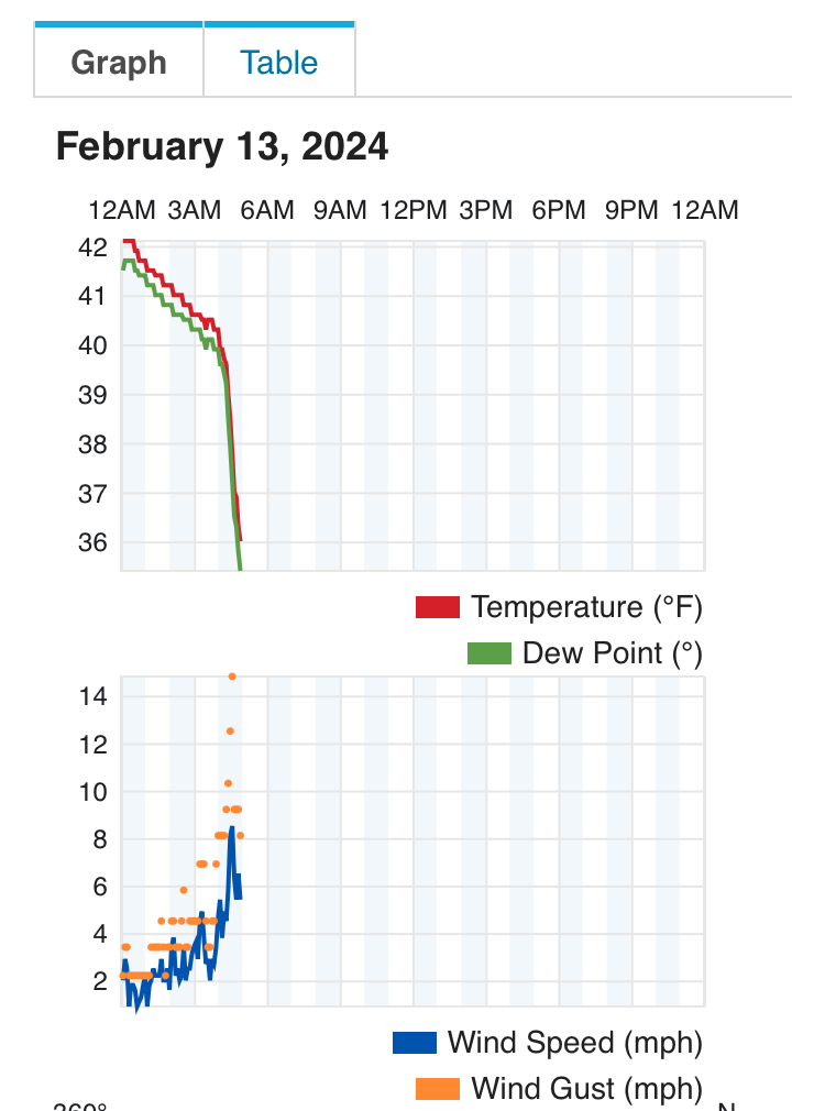
2/13 - 2.3” Total* - 11.5” *Missed a snow event in January. No reading so likely closer to 12-12.5” -
2024 Valentines Day Who the Hell Knows - Comeback Thread
MillvilleWx replied to DDweatherman's topic in Mid Atlantic
Snow coming to an end here in 5N Frederick 2.3” is the total. Not bad for lower elevation. It dumped for hours this morning. Very scenic -
2024 Valentines Day Who the Hell Knows - Comeback Thread
MillvilleWx replied to DDweatherman's topic in Mid Atlantic
5N Frederick -
2024 Valentines Day Who the Hell Knows - Comeback Thread
MillvilleWx replied to DDweatherman's topic in Mid Atlantic
Officially flipped to snow at 5:07am. Massive flakes -
2024 Valentines Day Who the Hell Knows - Comeback Thread
MillvilleWx replied to DDweatherman's topic in Mid Atlantic
This is very impressive. Sleet mixing in now with the rain. Only a matter of time.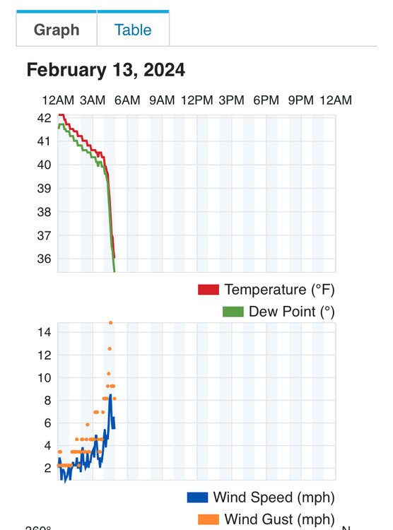
-
2024 Valentines Day Who the Hell Knows - Comeback Thread
MillvilleWx replied to DDweatherman's topic in Mid Atlantic
Yeah. You aren’t too far from me to the north. You should do fairly well with this one. Enjoy the nukage -
2024 Valentines Day Who the Hell Knows - Comeback Thread
MillvilleWx replied to DDweatherman's topic in Mid Atlantic
HRRR is a touch slow with the R/S line advancement, but it’s not too far off. Maybe 30 min. Snowing near Waynesboro now according to mPing. The bright banding on radar is wild. -
2024 Valentines Day Who the Hell Knows - Comeback Thread
MillvilleWx replied to DDweatherman's topic in Mid Atlantic
Whenever it flips, there will be steady rippage for 2-4 hrs before it slowly lets up. Precip rates are around 0.15-0.25”/hr at this point according to the local weather station right across the street. That’s plenty for 1-2”/hr snowfall rate. Will lose a little in the beginning to cool the surface, but once it’s established, off to the races. -
2024 Valentines Day Who the Hell Knows - Comeback Thread
MillvilleWx replied to DDweatherman's topic in Mid Atlantic
Snowing in the Catoctins just to my north. Temp and dew point are plummeting in my hood as we speak. Probably a hour or so before it flips and rips. Seeing snow reports on mPing across the PA line. HRRR doing a solid job with the R/S line advancement. -
2024 Valentines Day Who the Hell Knows - Comeback Thread
MillvilleWx replied to DDweatherman's topic in Mid Atlantic
It’s close. He’s not highlighting the elevation areas within the 1-3” shading, so it’s a broadbrush. Could be right, but I hate maps that don’t provide the detail along the ridge areas that ride along MD27 and along the M/D. For a quick map, it’s not bad. -
2024 Valentines Day Who the Hell Knows - Comeback Thread
MillvilleWx replied to DDweatherman's topic in Mid Atlantic
I really do think there is going to be an elevation marker that will make or break snow totals in this one. My gut is around 500ft +/- 50ft. It’s going to be that tight. I do like the northern crew on a line from the Catoctins across north-central Carroll and Baltimore Counties, then the northern tier of Harford and Cecil towards the PA line. Areas that have the best chance to do well are; Thurmont, Sabiasville, Taneytown, Emmitsburg, Manchester, Hampstead, Parkton, Jarrettsville, Norrisville, areas north of Rt 1 in Cecil, the entire southern tier of PA along the M/D. Additional areas that could cash decently include WV Panhandle, Mount Airy, Damascus, and terrain in Western HoCo. Any of these areas will have a shot at 2+” of snow imo with the best opportunity for high end advisory. Outside that is probably a 1-3” deal at best with the cutoff at 250ft elevation and south of I-66. This is my initial forecast just gleaning over everything and taking climo and BL temps into consideration. -
2024 Valentines Day Who the Hell Knows - Comeback Thread
MillvilleWx replied to DDweatherman's topic in Mid Atlantic
Definitely the right call. Elevation areas north of I-70 I would be pretty excited. -
2024 Valentines Day Who the Hell Knows - Comeback Thread
MillvilleWx replied to DDweatherman's topic in Mid Atlantic
I haven’t seen a sounding like this since Jan 2011. I’m not even kidding. Good lord -
2024 Valentines Day Who the Hell Knows - Comeback Thread
MillvilleWx replied to DDweatherman's topic in Mid Atlantic
RAP/HRRR bias at this range is too heavy with precip and will adjust. However, this is a fairly dynamic event, so it might not be THAT far off. This is a tightrope forecast. There will be winners and losers within close proxy of each other. The higher your elevation, the better. Especially if you have latitude. -
2024 Valentines Day Who the Hell Knows - Comeback Thread
MillvilleWx replied to DDweatherman's topic in Mid Atlantic
I think flakes will fly, but not really amount to much. I think the max is 1-2” if literally everything broke right. This is more for MD and points and north -
2024 Valentines Day Who the Hell Knows - Comeback Thread
MillvilleWx replied to DDweatherman's topic in Mid Atlantic
My thought is to prepare for potential snowstorm across Cecil county and points northeast. It’ll be a heavy wet snow and accumulate on elevated surfaces first. It could be tricky travel tomorrow morning and afternoon. The trend is undeniable at this point. Utilize mesos now and ensemble based products -
2024 Valentines Day Who the Hell Knows - Comeback Thread
MillvilleWx replied to DDweatherman's topic in Mid Atlantic
That would be some serious mashed potatoes if that verified. Huge flakes