MillvilleWx
-
Posts
5,530 -
Joined
-
Last visited
Content Type
Profiles
Blogs
Forums
American Weather
Media Demo
Store
Gallery
Everything posted by MillvilleWx
-
Low of 62 as well at mi casa. I’m driving to work with the windows down today. Beautiful
-
What a great morning to walk out into on my way to work. Can feel the drier air in the area. Temp was 67° when I left Frederick. This will begin a streak of superb mornings and gorgeous afternoons. Enjoy!!
-
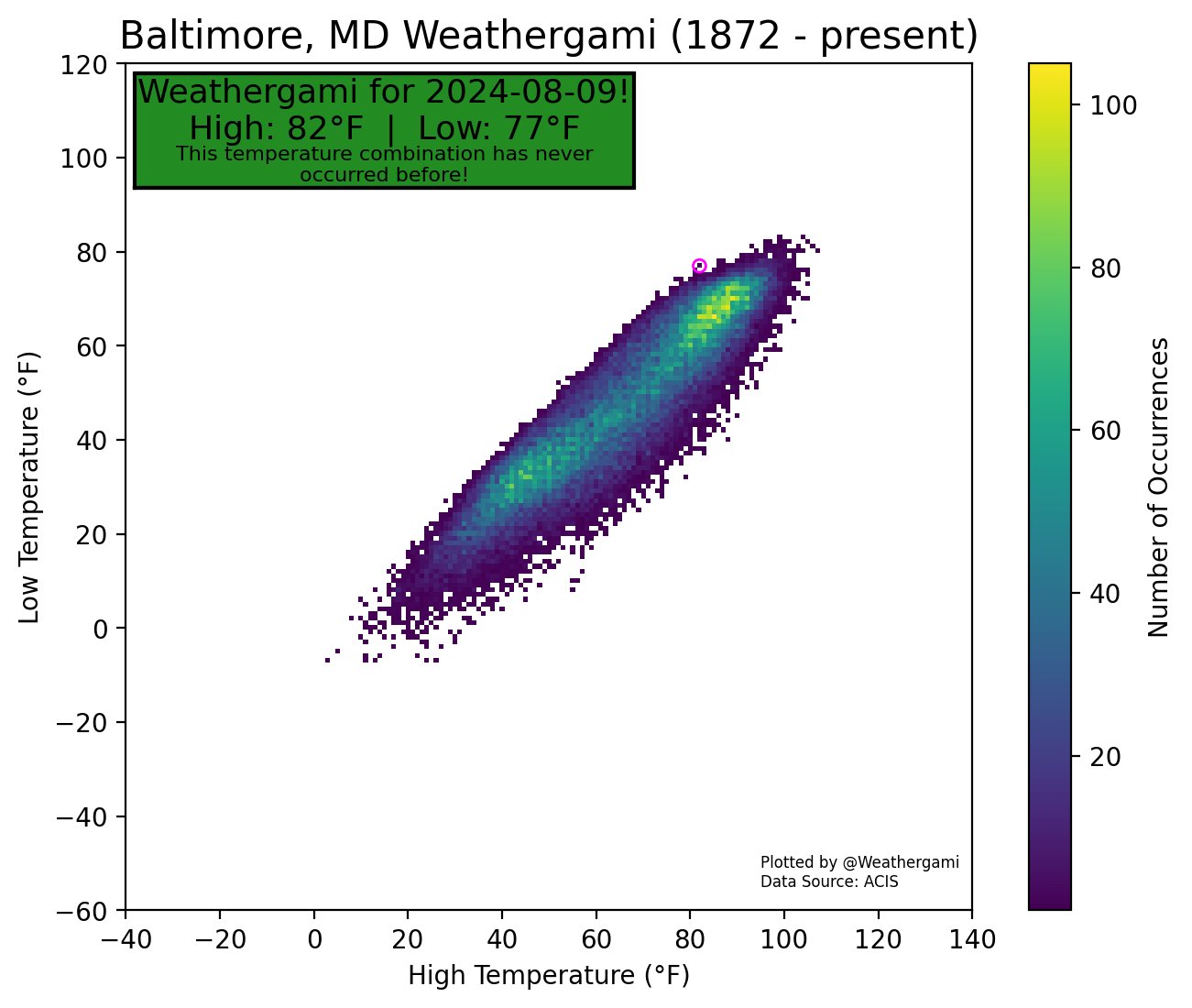
Here’s a cool nugget from today. Baltimore produced a temp profile that has never occurred since records have been kept. A Weatherigami!

- 924 replies
-
- 11
-

-

-

-
This is a prime period of weather incoming. A perfect time to get outdoors when you can. Going to do some sunset walks this weekend to partake in the tranquility
-

Tropical Storm Debby: Mid-Atlantic Impacts
MillvilleWx replied to WxWatcher007's topic in Mid Atlantic
8/7: 1.14" 8/8: 3.57" 8/9: 0.75" Storm Total: 5.46" (PRE and Remnants) August total up to 6.48" -
Tropical Storm Debby: Mid-Atlantic Impacts
MillvilleWx replied to WxWatcher007's topic in Mid Atlantic
Hold that thought. Just got hammered with a cell that popped up over Frederick. Updated totals after it's done -
The weather for Beltway series is going to be fantastic. Heading to the game with my Dad on Tuesday. Looks like low-mid 80s to start with temps falling into the upper 70s by back half of the game. Couldn't ask for better
-
Tropical Storm Debby: Mid-Atlantic Impacts
MillvilleWx replied to WxWatcher007's topic in Mid Atlantic
8/7: 1.14" 8/8: 3.57" 8/9: 0.57" Storm Total: 5.28" (PRE and Remnants) August total up to 6.30" What a month. The ground is already greening up again. Splendid -
Tropical Storm Debby: Mid-Atlantic Impacts
MillvilleWx replied to WxWatcher007's topic in Mid Atlantic
3.12” at mi casa since 4 PM yesterday. Boy that was nice to see this morning when checking the obs -
Tropical Storm Debby: Mid-Atlantic Impacts
MillvilleWx replied to WxWatcher007's topic in Mid Atlantic
Storm is definitely going through extra tropical transition. A fairly stout axis of deformation is beginning to unfold around I-77 down in the Carolinas. We’ll see that come into play for the heaviest axis of precip. The Shenandoah is going to get hammered, as well as the adjacent Blue Ridge. Areas that desperately needed rain out there should get it.- 681 replies
-
- 19
-
-
Tropical Storm Debby: Mid-Atlantic Impacts
MillvilleWx replied to WxWatcher007's topic in Mid Atlantic
D1 ERO out on the main WPC page with discussion. D2-3 will be out around 430 PM, at the latest -
Tropical Storm Debby: Mid-Atlantic Impacts
MillvilleWx replied to WxWatcher007's topic in Mid Atlantic
For those curious on the latest blend probabilities: 07z NBM >2” Storm Total: 50-80% area wide west of the Bay 07z NBM >3” Storm Total: 30-60% with a max of 65-70% over Carroll and Frederick Counties (North of I-70) 07z NBM >5” Storm Total: 10-25% area wide with highest northwest of the Fall line- 681 replies
-
- 16
-
-
-
Tropical Storm Debby: Mid-Atlantic Impacts
MillvilleWx replied to WxWatcher007's topic in Mid Atlantic
This usually happens as we get closer with convectively dominant systems. Unlike usual tropical impacts that have a broader QPF distribution, this one will have a more defined heavy rain axis as the circulation gets absorbed into the front. The timing of the trough picking up Debby and interacting with the front will be crucial for where the heaviest rain will fall. As of now, the consensus is along and west of the Fall line for greatest threat of 2+” tomorrow. We’ll see how defined that stripe will be as we get closer. There’s a shot someone gets 4-5” of rain if a train echo develops, but anyone outside of the band gets less than half of that. Nature of these types of systems. It’ll be fairly progressive Thursday night through Friday as well once it gets picked up. -
Tropical Storm Debby: Mid-Atlantic Impacts
MillvilleWx replied to WxWatcher007's topic in Mid Atlantic
We have a day by day breakdown via our website, I believe sites like Weatherbell and Pivotal can be broken down day by day as well! There’s going to be some scattered convection later today through the evening that could put down some local totals exceeding 1” with the best chance likely along and north of Rt 50. Slight Risk ERO out for the Delmarva to about I-95, which was continuity from my forecast yesterday. A new update will be out around Noon (16z) for the ERO. QPF update out by 130PM (1730z). Similar cadence all year if you’re wondering!- 681 replies
-
- 12
-
-
-
Tropical Storm Debby: Mid-Atlantic Impacts
MillvilleWx replied to WxWatcher007's topic in Mid Atlantic
That was one hell of an ERO desk shift today with more to come this week. Not going to lie, I had a lot of fun. Love the challenge. If you ever want to know if that’s me doing the forecast, check the Excessive Rainfall Discussion and look for “Kleebauer” on the sign off. Hoping we bring home the goods this week.- 681 replies
-
- 22
-
-
Tropical Storm Debby: Mid-Atlantic Impacts
MillvilleWx replied to WxWatcher007's topic in Mid Atlantic
I’ll see what I can come up with -
One of the tools we’ve been utilizing for forecasts in violatle setups has been AI models because they have a deep data set to work off of and don’t utilize complex physical properties to base the forecast. They are good for assessing track trends based on the current data instituted in initialization then go off pattern recognition for future evolution. Not always right, but can give a ballpark of what to expect. AI focus has been along the coastal plain and less inland advancement of deep tropical moisture. This has been the case for multiple days on the ECMWF AIFS and Graphcast, as well as the GFS Graphcast. This should be a red flag for the previous GFS/ECMWF iterations that showed wildly deviant outcomes compared to AI. This is the next Gen of tools to use to monitor potential trends, especially when the AI guidance is steady state in the forecast. There is still a lot of assessment to be done to analyze just how well the AI models are verifying, so it’s not full proof, but just like when the deterministic is wildly different from its ensembles, that should be a clue as to the expected trend. Another note is AI is not practical for rainfall/precip magnitude but more for a general placement of organized precip based in large scale synoptic regimes. It still struggles with disorganized convective patterns due to the intrinsic variables at hand with complicated thermodynamic processes that control the initiation prospects. That might be a bit before AI catches on there, so take those types of outputs with a grain of salt.
-
Only 0.04” so far. A quick moving shower dropped a few hundredths earlier. Getting skirted to the north by the big storm over Southern FDK. 81/75
-
0.7” on the nose here in North Frederick. Temp down to 73° Wife and I were driving to Jimmie Cone earlier and the heavens opened up. Still got my ice cream. Nothing was going to keep us from the scrumptious high butter fat creamy goodness.
-
Also did an assessment of my rainfall this year around mi casa. Looks like 27.40” so far this year according to a station very close to me. Jives with the surrounding totals. I’m kind of shocked Northern FDK has had that much. Unfortunately, the totals to my south are not nearly as good Sorry to all my southern FDK/Ballanger Creek peeps
-
Definitely a better shot at convection further north today, although a sneaky vort max on the southeastern periphery of the ridge could surprise south of I-70 somewhere. Not a great chance, but non-zero. Tomorrow is the best shot at widespread convection. We really could use a convective blob across the region. Fingers crossed I’m ready for fall
-
I have officially been back in MD for a full year, today! WOW has time flown. Still feels amazing to be back. I’m never leaving again.
- 152 replies
-
- 11
-
-
It’s nice to be in the home stretch of summer. First NFL-ish game of the year tonight so that means we are on the backside of hell…I mean summer
-
Looks like the Orioles didn’t want to mortgage the future and trade their top talent this go around. Apparently the asking price for multiple top end starters was ridiculous as per some reports from GM’s around the league. Guys like Crochett and Skubal ended up not being traded anyway. I still don’t think this team is good enough to win a WS with the bats, let alone the bullpen. We’ll see how it all plays out, but sucks we have a top 3 pitcher in baseball for one year and probably won’t win it. He’s as good as gone after this season