

MillvilleWx
-
Posts
5,530 -
Joined
-
Last visited
Content Type
Profiles
Blogs
Forums
American Weather
Media Demo
Store
Gallery
Everything posted by MillvilleWx
-

January Medium/Long Range: A snowy January ahead?
MillvilleWx replied to mappy's topic in Mid Atlantic
No question about that. So happy I went there for my degree. Met and made friends with some amazing people along the way. Hopefully all is well up in LNS territory! Let’s kick this January off with a bang! -
January Medium/Long Range: A snowy January ahead?
MillvilleWx replied to mappy's topic in Mid Atlantic
He deserves the reddest of tags. Pete is an amazing meteorolgist and one of the primary Winter Desk forecasters at WPC. I went to school with Pete. Great guys and very knowledgeable. This is the type of work that is done when looking at the big picture. It’s not just hemming and hawing over every single deterministic output. Yes, it’s great to look at, but parsing the details on the why is why we love what we do. I’ve been utilizing Cluster Analysis via DESI v3.2 which I unfortunately can’t share and trying to see the behavior of ensembles and potential outcomes. Pete broke down the primary features and some sneaky elements that could very easily sway the forecast. I hope people get a lot out of the information provided. It’s one of the ways I learned about how things work in the synoptic world when it comes to Winter Systems. Years of just reading on here from previous Red taggers and knowledgeable posters. Been a great experience with a ton of laughs in the mix. Hopefully we can bring this one home! -
January: Medium/ Long Range: May the Force be with Us....
MillvilleWx replied to Weather Will's topic in Mid Atlantic
All the hemming and hawing over the GFS deterministic output all while the GEFS has improved, for most run to run for the past 8 cycles lol I'm not saying we're going to get clobbered or that we're going to miss. I'm saying the trends are still decent for the area despite the deterministic outputs. I'm not worried at the moment. I'll let you know if I am! If there was anyone that should keep close tabs on the setup for shifts, it's NE MD just due to the nature of the confluence. Still could get snow up there, but it's likely to be greater further west and south. I have family near where I grew up, so I'm watching that area closely.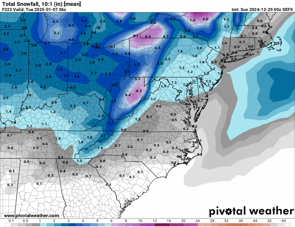
-
January: Medium/ Long Range: May the Force be with Us....
MillvilleWx replied to Weather Will's topic in Mid Atlantic
Yeah, and considering the time frame of expected impact and spread, I'm sure my colleague went pretty conservative on QPF which is one of the reasons the output is lighter than what most of the recent deterministic have shown. I will say the current output on the snow is a good sign and is within that general grand ensemble mean from the cluster analysis depicted on the 12z suite. I think 3-6" with as much as 8" or 9" is plausible in the setup as shown. Still time for adjustments in either direction but remain cautiously optimistic. -
January: Medium/ Long Range: May the Force be with Us....
MillvilleWx replied to Weather Will's topic in Mid Atlantic
I just came here to mention this as well. -
January: Medium/ Long Range: May the Force be with Us....
MillvilleWx replied to Weather Will's topic in Mid Atlantic
This is my feeling as well and the fact it agrees with the majority of ensemble outputs on all major globals when assessing cluster analysis gives me optimism -
January: Medium/ Long Range: May the Force be with Us....
MillvilleWx replied to Weather Will's topic in Mid Atlantic
Inside 60 hrs. Still a ways to go! -
January: Medium/ Long Range: May the Force be with Us....
MillvilleWx replied to Weather Will's topic in Mid Atlantic
The model very likely has a small decision tree approach when it comes to ptype dissemination, so any nose above the 0°C threshold will ultimately shift the ptype to a more mixed variety. Pending the depth of the omega between 850-600mb and the intensity of the precip, the result could still yield snowfall, albeit more clumped aggregates and lower ratios. The warm advection regime within the boundary layer will ultimately cause a changeover somewhere with the current southerly flow magnitude being progged. Climo suggests those Fredericksburg on south would have the highest potential with Southern MD likely to be next on any northerly adjustment. I think those that are along and north of Rt50 should stay all snow with this one with realistically the zone north of Fairfax/Northern Prince William/Charles counties probably maintaining most, if not all snow. Would need this storm to cut further north to threaten those zones. Best accums will be within the 7H and 85H FGEN areas with the northern periphery seeing best ratios to offset the “lighter” precip potential. 85H FGEN will have slightly lower ratios, but more precip. This is a good dual maxima setup wherever this sets up. Jury still out, but I still think this ends up a Central VA on northward storm. Ensembles have been pretty insistent on that. GFS waffling on location should be a major red flag in terms of forecasting. Until other models follow suit and/or GFS becomes steadily locked in for multiple days, I don’t see its 12z representation being the final solution. -
Oh God
-
New longevity record?
-
January: Medium/ Long Range: May the Force be with Us....
MillvilleWx replied to Weather Will's topic in Mid Atlantic
Yoda, I have two things. First, the black and white maps do look decent to my trained eye. Have to take a closer look once the other visuals are out. Second, I’m gonna start billing you for my eye doctor after all these years trying to read these damn things -
I actually will purposefully add more value to that area and other types across the CONUS the last 30 min of my forecast time frame before the deadline. It adds a lot of value to the forecast. I’ll be keeping tabs on that spot for sure with this setup!
-
January: Medium/ Long Range: May the Force be with Us....
MillvilleWx replied to Weather Will's topic in Mid Atlantic
Word to the wise: As we get closer to the storm time, please leave all opinion pieces and inexperienced meteorological breakdowns out of the thread, please. I could sit here and post like crazy, but I let the run finish. We have a good set of PBP guys here for these types of events. Let them post and then comment after everything is over. Sincerely, Your friendly neighborhood Meteorologist -
January: Medium/ Long Range: May the Force be with Us....
MillvilleWx replied to Weather Will's topic in Mid Atlantic
I’m curious at what type of ratios we come up with over the weekend at the winter desk. I’d wager an avg of 10-11:1 for most here, but some of the better FGEN banding will probably poke 14-15:1, especially the 7H FGEN which will lie on the northern edge of the best QPF. Still fun to talk about snow in these parts before the hammer drops. Will feel like deep winter. -
Hey Cashtown! Sadly, I don’t work the Medium Range desk, so I will not be producing any of the QPF maps between D4-7. Hopefully we see a nice uptick as we move closer in time. D1-3 are when I have the ability to make the QPF maps, and that will actually be the case this weekend as I work the QPF desk on night shifts. Catch my work then
-
January: Medium/ Long Range: May the Force be with Us....
MillvilleWx replied to Weather Will's topic in Mid Atlantic
Anytime! This is what I do and love to look at. Hopefully we ring in the New Year with a great event and get the winter rolling. -
January: Medium/ Long Range: May the Force be with Us....
MillvilleWx replied to Weather Will's topic in Mid Atlantic
The GFS and CMC moving north match the cluster analysis of the greatest percentile of ensemble members between the 12z GEFS/ECENS/GEPS from earlier. This is likely some beginning of stabilizing in the evolution. There will be changes in magnitude and orientation of the 7H moisture feed over the coming days, but I think the trend of the North Atlantic gyre being further northeast was a big step in the right direction for the region. Still a ways to go and minor adjustments in either the primary ULL over the Mid-South or the North Atlantic Gyre will cause some deviations in the poleward advancement of the main moisture feed. Good trends tonight. Happy New Year everyone! -
January: Medium/ Long Range: May the Force be with Us....
MillvilleWx replied to Weather Will's topic in Mid Atlantic
18z GFS takes a step towards the ECMWF and resembles the primary cluster of ensemble guidance when reviewing the 12z cluster analysis. The Grand Ensemble was a mean of 2-3” area wide with the 1-2” mark all the way down to Roanoke and the 2-3” mark beginning Fredericksburg and north. The primary cluster representing a solid 39% of ensemble guidance had a mean of 2.5-4” with a more widespread 3” margin across NoVA up through Southern PA. I think we are seeing the GFS begin the shift of a weaker North Atlantic Gyre and more in-line with the primary ensemble consensus. If that trends weaker, this will end up further north. Need the primary ULL over the Mid-South to stay robust so it can gear up prior to reaching the Tennessee Valley before it eventually gets sheared and the moisture axis funnels up into our hood. Atecedent airmass is prime, so the main ptype should be snow for most of us. -
Knowing where is sometimes half the battle! We had so many places in mind, so I'm glad we are exploring where to settle. Mt Airy seems like the best fit, but we are enjoying AA county right now, so we will be weighing our options in the near future. There's some beautiful communities in both areas so we have our work cut out for us.
-
I did actually. Moved to Edgewater the end of July. Loved my time in Frederick, but we felt it was better to be a little closer family and a shorter commute to work. We still might move to Frederick county as our final landing place since we are just renting currently. We love the Mt Airy area, so it's possible I end up back that way in time. Mt Airy is a perfect in-between spot for commute and family. Northern AA county is also possible. We will be weighing our options the next few years. 2026 is when we will likely purchase our first home!
-
I'll provide a little more on my take for your general area. I do like the idea of a more robust QPF shield being depicted amongst the guidance considering the favorable 5H pattern. The ECMWF is more amplified thus bring warmer air into the boundary layer faster and giving the TN Valley area mostly rain with perhaps a touch of ice at the onset. The GFS is playing some catchup and is the weakest of the guidance with a stronger cold pattern anchored into the region and takes much longer to scour out. Canadian is in the middle with an ice to rain type scenario with areas north of I-40 possibly starting as snow before flipping to sleet/ZR. Still tricky to come up with a definitive solution at this point, but I do like the precip field being more broad and robust compared to the proverbial "weak sauce" that the GFS was depicting in prior runs. Hope you guys score down there! I have friends of mine that live in Glasgow, KY and they have an infant. It would be awesome for them to send my wife and I more pics of the little one in the snow
-
January: Medium/ Long Range: May the Force be with Us....
MillvilleWx replied to Weather Will's topic in Mid Atlantic
DAS!!! Man, between you and @mitchnick here, I'm getting all the nostalgia feels. Hope you are doing well! -
January: Medium/ Long Range: May the Force be with Us....
MillvilleWx replied to Weather Will's topic in Mid Atlantic
Been busy at work so just now getting a chance to assess things. So far there is still significant spread with the handling of the 5H pattern across the North Atlantic with the extension hanging back into the Northeastern U.S. @CAPE pointed out earlier some of the appreciable differences upstairs with a touch more phasing of N/S energy extending back to Canada leading to a stronger axis of confluence and shearing of the primary 5H shortwave progression out of the Mississippi Valley. One positive take from the GFS was a better precip shield developing across the Mid-South, something that had been missing in previous runs. This makes sense considering the stronger closed 5H vorticity and subsequent 500mb LER jet dynamics accompanying the trough. There's likely to be shearing as a result of the cyclonic gyre over the North Atlantic, but we'll have to see if this is a case of Medium Range bias in over amplifying the 5H Relative Vorticity evolution as can be the case within these D4+ leads. I do feel the analysis of the eventual trough in the plains and Tennessee Valley will be solved a little faster given the time frame the energy reaches the CONUS and becomes a factor in cyclogenesis is <72 hrs in progression, so the fact that has trended favorably is a step in the right direction. Deterministic output has been shotgun spray when it comes to the final QPF within that D6-8 time frame as each global displays a different prog meaning there's very much variability in this pattern. These types of setups tend to lean further north due to the bias of over amplification of the downstream 5H evolution noted above, but that doesn't mean that will be the case this time. Ensembles have been pretty useful with regards to the anticipated QPF with the GFS boosting precip within the area over the past 4 runs (See @NorthArlington101 post above) and the other ensembles remains relatively steady with varying QPF magnitudes more noise within the mean. NBM maintains a general 2-4" across much of the sub-forum with the max situated over Central MD back west, a favored climo pattern for storms that run west to east in trajectory. I'm curious to look at the cluster analysis and see what differences within the ensemble members give us the best and worse case scenarios along with which cluster has the highest percentile of probable outcomes. Time will tell and until I see something more concrete in either a great or terrible scenario, I have no strong feelings on what has been shown on todays 12z suite. Just my $0.02 -
DON'T SAY IT. DON'T SAY IT. DON'T SAY IT. DON'T SAY IT. DON'T SAY IT. DON'T SAY IT. DON'T SAY IT. DON'T SAY IT. DON'T SAY IT. DON'T SAY IT. DON'T SAY IT. DON'T SAY IT. DON'T SAY IT. DON'T SAY IT. DON'T SAY IT.......
-
It was really chilly in the lowlands of AA this morning. I was around 33F myself with frost on the windshield. Quite pleasant. I love cool/cold mornings


