WxWatcher007
-
Posts
36,088 -
Joined
-
Last visited
Content Type
Profiles
Blogs
Forums
American Weather
Media Demo
Store
Gallery
Everything posted by WxWatcher007
-

The event of the season - 2 days of hell!
WxWatcher007 replied to Go Kart Mozart's topic in New England
We hold, for now. -
It’s coming. Embrace it and hope for a strong fourth quarter in late Feb/early March that puts meaningless numbers on the lopsided scoreboard. Don't worry MA and points north, I’m not stealing your snow. I’m talking about the lowlands.
-
The event of the season - 2 days of hell!
WxWatcher007 replied to Go Kart Mozart's topic in New England
Can't wait for the weenie NAM and HRRR runs that show -20 in Hartford...or the models moderating the cold by 30 degrees 24 hours out to keep the futility theme going. -
The event of the season - 2 days of hell!
WxWatcher007 replied to Go Kart Mozart's topic in New England
I’m looking for a getaway. How is Fort Kent in general for a weekend trip? -
The event of the season - 2 days of hell!
WxWatcher007 replied to Go Kart Mozart's topic in New England
It’s different because it’s snow, but I’ll always remember being out for hours during this Watertown LES event. It had it all. Blizzard warning, SN+, and big cold.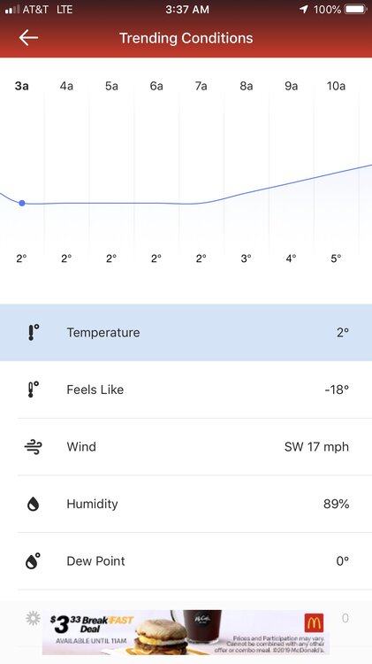
-
The event of the season - 2 days of hell!
WxWatcher007 replied to Go Kart Mozart's topic in New England
My coldest recorded was -10 at Saranac Lake. -
The event of the season - 2 days of hell!
WxWatcher007 replied to Go Kart Mozart's topic in New England
I need a house up there. -
The event of the season - 2 days of hell!
WxWatcher007 replied to Go Kart Mozart's topic in New England
I did it in December when it was 5 or 6° and it was pretty cool. -
The event of the season - 2 days of hell!
WxWatcher007 replied to Go Kart Mozart's topic in New England
Can we go any lower? -
The event of the season - 2 days of hell!
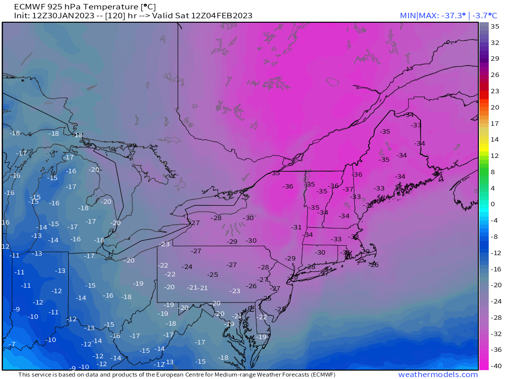
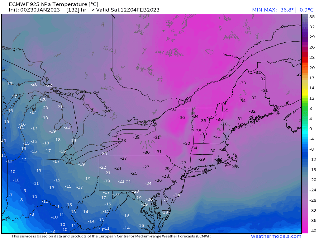
WxWatcher007 replied to Go Kart Mozart's topic in New England
925s look a little colder than 00z.
-
The event of the season - 2 days of hell!
WxWatcher007 replied to Go Kart Mozart's topic in New England
Still a little skeptical we get a direct hit, but that’d be very impressive. -
If I had to choose between 1-2” of snow and realizing -10 imby, I’d take the cold. Far more anomalous.
-
A little interesting to see the GFS move the precip with that wave Friday move closer and closer. On an island.
-
Two low end warning level events would get me to 18”. Let’s be generous and say that there are three additional 4” events. That just gets me to 30”, or 2/3 of climo. That’s not terribly close imo. Say nothing of the fact that we’d need 5 substantial snow events over the next 8 weeks lol.
-
This. Congrats NNE, but down here in the lowlands of CT we’re rolling into February at less than 20% of climo snow. I’m at 13% of climo and the warmth has been absurd. We’re not even in the game seriously to be in striking distance of normal. It’s ok to be real about the unfolding disaster. It hadn’t been everywhere, but it has been here. Even when it does snow again, we need a historic period to claw back close to climo.
-
The event of the season - 2 days of hell!
WxWatcher007 replied to Go Kart Mozart's topic in New England
Is there an easy way to look up dates on the NWS site? For example—the last time BDL recorded -5, the last time BDL recorded 12” in 24 hours, etc.? -
The event of the season - 2 days of hell!
WxWatcher007 replied to Go Kart Mozart's topic in New England
Yeah—anything close to this and we deep freeze lol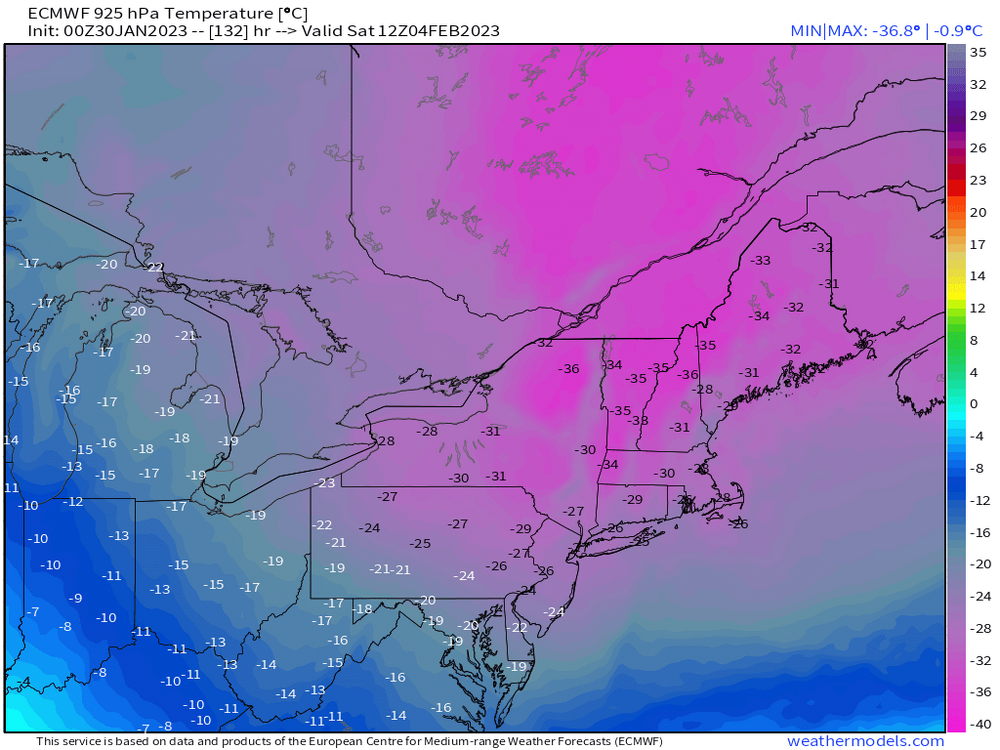
-
The event of the season - 2 days of hell!
WxWatcher007 replied to Go Kart Mozart's topic in New England
I love it. Let this epic cold be a memorial to our futility this season. -
Drink!
-
You have to know better in that play. Hate to see it potentially end like that.
-
What a game.
-
The event of the season - 2 days of hell!
WxWatcher007 replied to Go Kart Mozart's topic in New England
-
I also don’t think we’re really “jumping on” the temp forecast verbatim. A lot of caution flags are up, but the overall idea of big cold doesn’t seem absurd.
-
Our winter down here has been all time horrific. The real question is who hasn’t melted?
-
The event of the season - 2 days of hell!
WxWatcher007 replied to Go Kart Mozart's topic in New England
First guess of max lows. PWM: -9 MHT: -12 BTV: -20 ORH: -8 BOS: -2 PVD: 0 BDL: -2 HFD: 0 BDR: 2