WxWatcher007
-
Posts
36,051 -
Joined
-
Last visited
Content Type
Profiles
Blogs
Forums
American Weather
Media Demo
Store
Gallery
Everything posted by WxWatcher007
-
1.25” in 40 minutes. 1.42” in an hour. We flood, again.
-
Absolute deluge here
-
Nasty at the shore. Nice lightning here and torrential rain coming fast.
-
Yeah I should have said snow rather than blizzards—that’s happened before. Being dramatic
-
I will readily admit I’m out of my depth here. Tracking tropical for the desert southwest is like tracking a blizzard for Miami.
-
Well that’s the thing, right? It’s probably great for the basins, but in those desert and urban areas it just runs off. If it verifies God help people unaware enough to travel into some of those parks.
-
98L, although convectively disorganized, looks to be leading the pack as it has a more robust low level spin and maybe some convection trying to organize. It’s the front runner tonight to be the first NS since Don, though a combination of dry air and shear will likely kill it next week. 98L is more convectively active but it still looks to be tied up in the monsoon trough with elongated vorticity and is still connected by my eye to the new lemon just to the west. That lemon, which the Euro continues to like, could become a player for the Antilles of it can separate. It should be noted that this region has been most convectively active, so it stands to reason if it can acquire spin and avoid SAL to the north given its location it has a legitimate chance. Meanwhile, nothing new for the Gulf lemon. Still worth watching but I don’t think we get a better sense of things until the disturbance reaches the Gulf.
-

2023 Atlantic Hurricane season
WxWatcher007 replied to Stormchaserchuck1's topic in Tropical Headquarters
98L, although convectively disorganized, looks to be leading the pack as it has a more robust low level spin and maybe some convection trying to organize. It’s the front runner tonight to be the first NS since Don, though a combination of dry air and shear will likely kill it next week. 98L is more convectively active but it still looks to be tied up in the monsoon trough with elongated vorticity and is still connected by my eye to the new lemon just to the west. That lemon, which the Euro continues to like, could become a player for the Antilles of it can separate. It should be noted that this region has been most convectively active, so it stands to reason if it can acquire spin and avoid SAL to the north given its location it has a legitimate chance. Meanwhile, nothing new for the Gulf lemon. Still worth watching but I don’t think we get a better sense of things until the disturbance reaches the Gulf. -
I’m not sure, but I spoke to a friend from LA and he said he’s hopeful this’ll act to suppress fire season.
-
Impressive improvement in appearance in just the last few hours
-
No special analysis here but Hilary is almost certainly a major hurricane now given the continuous improvement on IR especially the last few hours. Now it’s a question of how high it can go. (time sensitive)
-
1939 for a sea to land landfall, but I think 97 was the last time a designated TS was over CA. Yeah I’d sell that.
-
Hilary has the look. Might be a big time event in southern CA.
-
2023 Atlantic Hurricane season
WxWatcher007 replied to Stormchaserchuck1's topic in Tropical Headquarters
Interesting end to the Euro as that western area I just mentioned maybe gets left behind by a trough and the EPAC ejects vorticity into the BOC leading to a TC in the Gulf. Not really worth much headspace, just a reminder of how complex this overall evolution is--there will be opportunities for TC genesis though, IMO. -
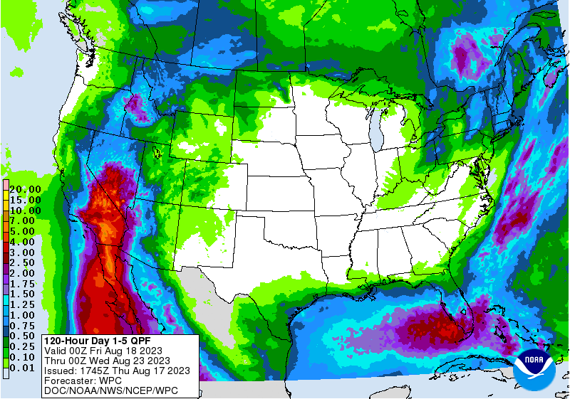
Considering that some of these areas don't get this much rain in a year, it could get real bad if this forecast verifies.
-
2023 Atlantic Hurricane season
WxWatcher007 replied to Stormchaserchuck1's topic in Tropical Headquarters
12z runs again show a complicated setup in the Atlantic, with a potentially weak system in the Gulf, high uncertainty (but low ceiling) for the areas along the disintegrating monsoon trough, and a long range potential for a CAG to develop. The Euro continues to actually focus MDR development further west, with a brief TC in the Caribbean before running into a buzzsaw of shear. Verbatim, it'd be a risk for PR and the USVI early next week. The Gulf thing becomes a weak system, but doesn't have time to consolidate enough to organize into something stronger. -
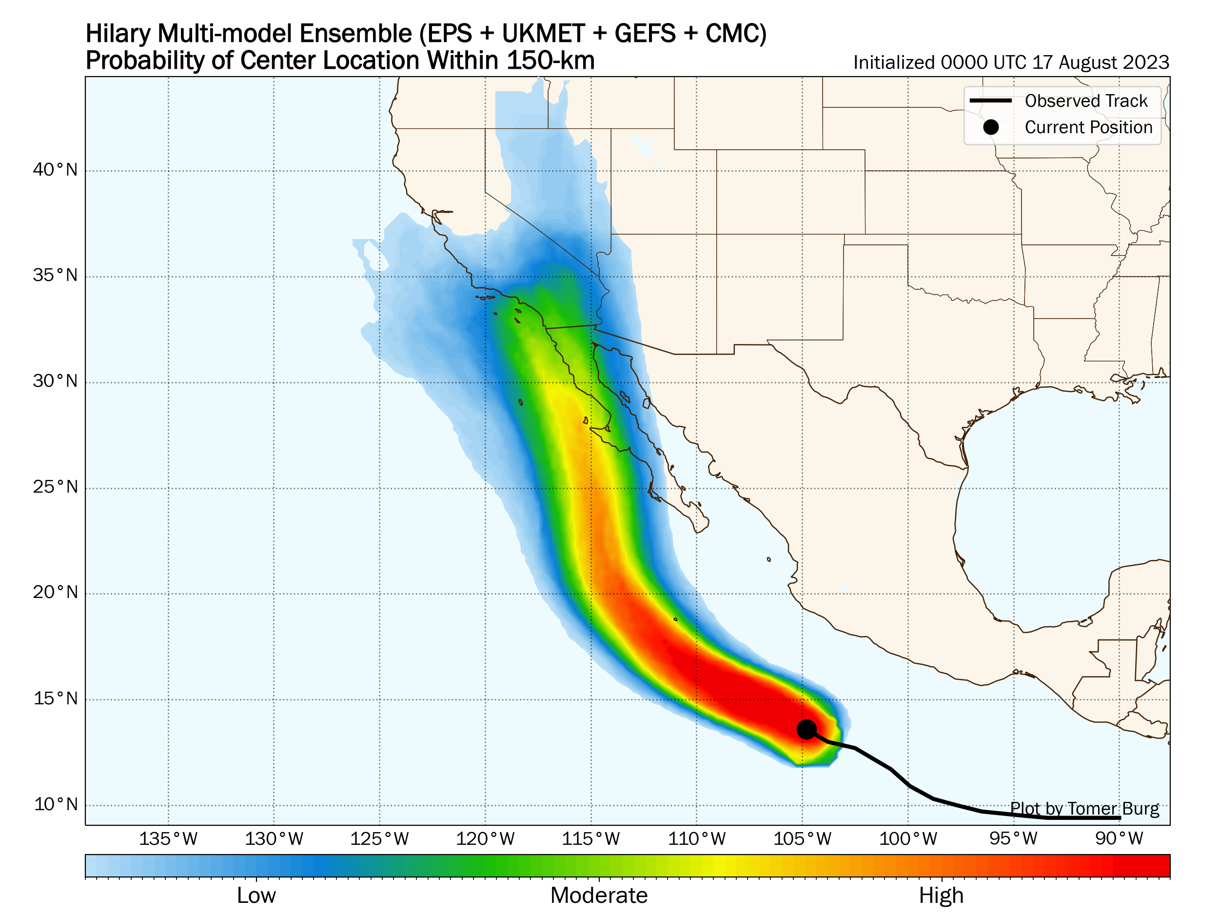
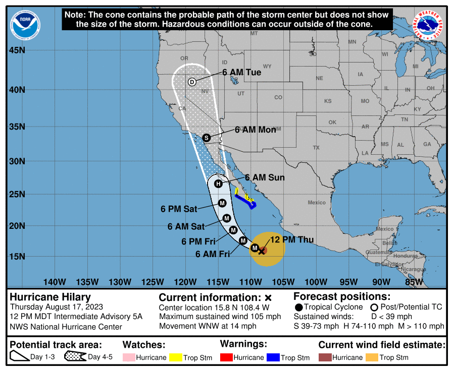
I know we rarely have separate threads for EPAC systems, but given the current NHC track and potential high impact in the SW US, I think it's worth a thread. Hilary is currently undergoing rapid intensification, with it attaining category two status as of the noon MDT (2pm EST) NHC intermediate advisory. As you can see on the recent IR image, an inner core has developed and we have an apparent attempt to clear the eye. The current environment for intensification is about as good as it gets, and this should easily reach major hurricane status. An anomalous steering pattern with an eastward shifting ridge and trough west of CA looks more likely, causing Hilary to move NW into Baja and potentially southern California. Despite the track and intensity forecast generally being solid, we still have significant uncertainty as Hilary approaches Baja and the SW US. In terms of impact, while it's novel to have an actual tropical storm in California, it looks like rainfall and flooding will be the main hazard, with a rare moderate risk for excessive rainfall for part of southern CA

-
2023 Atlantic Hurricane season
WxWatcher007 replied to Stormchaserchuck1's topic in Tropical Headquarters
https://twitter.com/philklotzbach/status/1692220172457971992?s=46&t=Nn9Cx92_8118fPdhHPdJHw -
https://twitter.com/philklotzbach/status/1692220172457971992?s=46&t=Nn9Cx92_8118fPdhHPdJHw
-
Year’s worth of rain in 24-48 hours in the dry areas would cause some trouble.
-
Explicitly forecast to be a TS over southern CA. Obviously there’s novelty to that but the rainfall impacts could be bad. Especially with a further west track that brings heavier rain toward the population centers at the coast IMO. Hurricane Hilary Discussion Number 5 NWS National Hurricane Center Miami FL EP092023 900 AM MDT Thu Aug 17 2023 Hilary has continued to intensify rapidly. The cloud pattern of this large hurricane is very impressive, with extremely intense deep convection and cloud tops to -80 deg C or colder. Well-defined banding features are evident over all quadrants of the circulation. The upper-level outflow pattern is quite symmetric and expanding. Satellite intensity estimates are wide-ranging and the Dvorak technique rules do not allow subjective current intensity estimates much above 65-70 kt. However based on data T-numbers the advisory intensity is set, perhaps conservatively, to 75 kt. The hurricane is moving west-northwestward, or about 300/12 kt. Over the next few days, a mid-level ridge to the north of Hilary is forecast to shift eastward while a mid-level low remains near the California coast. This evolution of the steering currents should result in a gradual turn toward the north in a couple of days, which would bring Hilary near the Baja California peninsula in 72 hours or so and near the U.S./California border in 3-4 days. The official forecast track is very similar to the previous one, and follows the HFIP corrected consensus, HCCA, guidance. Although there is fairly high confidence in the track prediction, Hilary's oblique angle of approach to the west coast of the Baja California peninsula makes it nearly impossible to know at this point if the center will remain just offshore or move over the peninsula before reaching the southwestern United States. Hilary is in an environment of low shear and high mid- to low-level humidity, and over very warm waters. The SHIPS rapid intensification (RI) indices show extremely high probabilities of rapid intensification during the next day or so. Therefore the official intensity forecast shows a 40-kt increase over the next 24 hours. Later in the forecast period, cooler waters and land interaction should result in some weakening. The official wind speed forecast is near or a little above the latest HCCA guidance. The surface circulation is likely to be dissipated by day 5, but a day 5 forecast point (as a remnant low) is still provided to maintain a forecast track over southern California. KEY MESSAGES: 1. Heavy rainfall associated with Hilary may produce areas of flash flooding and result in landslides over portions of Baja California Peninsula from late Friday into late Sunday. Rainfall impacts from Hilary within the Southwestern United States are expected to peak this weekend into Monday. Flash, urban, and arroyo flooding, is possible with the potential for significant impacts. 2. Hilary has the potential to bring significant impacts to the Baja California Peninsula and portions of the southwestern United States this weekend and early next week, including after it becomes post-tropical. Although it is too soon to determine the location and magnitude of wind impacts, interests in these areas should monitor the progress of Hilary and updates to the forecast. Tropical Storm Warnings and Watches are now in effect for southern portions of Baja California Sur, and additional watches or warnings will likely be required later today. 3. Large swells from Hilary will spread northward along the coast of southwestern Mexico and the Baja California Peninsula during the next several days. FORECAST POSITIONS AND MAX WINDS INIT 17/1500Z 15.5N 107.8W 75 KT 85 MPH 12H 18/0000Z 16.4N 109.4W 100 KT 115 MPH 24H 18/1200Z 17.6N 111.2W 115 KT 130 MPH 36H 19/0000Z 19.3N 112.7W 120 KT 140 MPH 48H 19/1200Z 21.2N 113.7W 115 KT 130 MPH 60H 20/0000Z 23.6N 114.4W 105 KT 120 MPH 72H 20/1200Z 26.6N 115.0W 85 KT 100 MPH 96H 21/1200Z 33.4N 116.8W 50 KT 60 MPH...INLAND 120H 22/1200Z 41.0N 119.0W 25 KT 30 MPH...POST-TROP/INLAND $$ Forecaster Pasch
-
First tropical landfall this year may be in California lol
-
The 2023 Lawn, Garden, Landscape Party Discussion
WxWatcher007 replied to Damage In Tolland's topic in New England
Crabgrass is awful -
Given the persistent troughing, I do think when we get something recurving off the EC in September or whatever there could be higher than normal chances of a PRE somewhere.
-
Yeah, the position and amplitude matter. We have some middling features out in the basin now but I think the highest potential comes late month if we can get a CAG in the western Caribbean. That’d bring something north off the SE coast or into the Gulf—if the activity doesn’t center in the EPAC.