

WxWatcher007
-
Posts
36,051 -
Joined
-
Last visited
Content Type
Profiles
Blogs
Forums
American Weather
Media Demo
Store
Gallery
Everything posted by WxWatcher007
-
-

2023 Atlantic Hurricane season
WxWatcher007 replied to Stormchaserchuck1's topic in Tropical Headquarters
-
Gotta watch what happens with that potential CAG in the Gulf/W. Caribbean at the end of the month.
-
This thread is always good for some laughs
-
Franklin with an absolutely epic tower going up right now.
-
Love it
-
-
I have a hard time seeing this coming apart before hitting one of the islands given how resilient it has been so far in the face of shear/dry air.
-
-
-
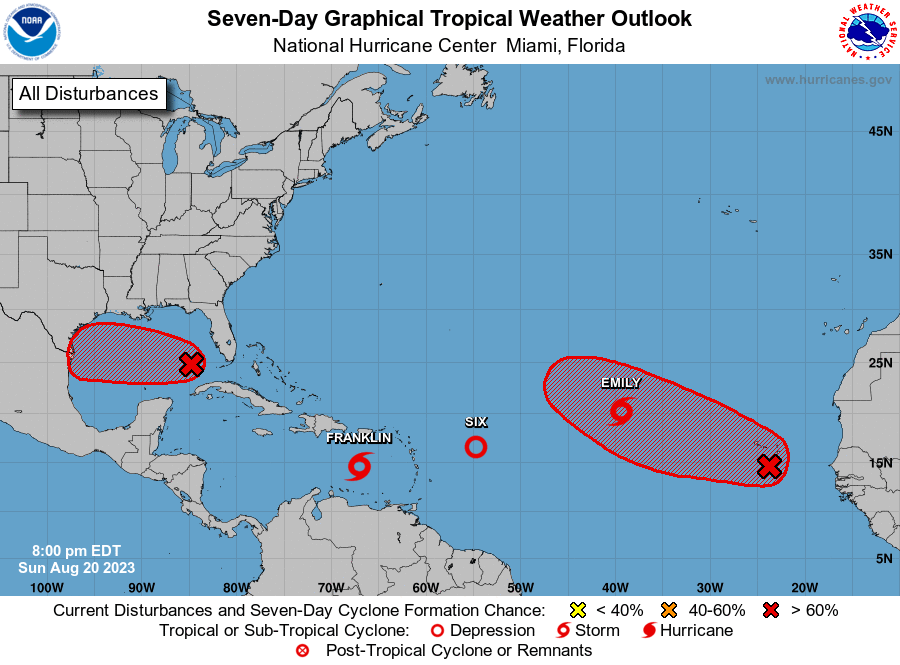
Tropical Weather Outlook NWS National Hurricane Center Miami FL 800 PM EDT Sun Aug 20 2023 For the North Atlantic...Caribbean Sea and the Gulf of Mexico: Active Systems: The National Hurricane Center is issuing advisories on Tropical Depression Six, located several hundred miles east of the northern Leeward Islands, on Tropical Storm Emily, located about 1000 miles west-northwest of the Cabo Verde Islands, and on newly formed Tropical Storm Franklin, located over the eastern Caribbean Sea. 1. Western Gulf of Mexico (AL91): Showers and thunderstorms have increased this evening, and are becoming better organized in association with a trough of low pressure located in the eastern Gulf of Mexico. Environmental conditions appear favorable for development of this system as it moves westward at about 15 to 20 mph across the central Gulf of Mexico. A tropical depression or storm is likely to form as it approaches the western Gulf of Mexico coastline by Tuesday. Interests in the western Gulf of Mexico should monitor the progress of this system. Tropical storm watches or warnings may be necessary on Monday for portions of the southern Texas and northern Mexico coastlines. * Formation chance through 48 hours...high...70 percent. * Formation chance through 7 days...high...70 percent. 2. Eastern Tropical Atlantic: A large area of disorganized showers and thunderstorms over the far eastern tropical Atlantic is associated with a tropical wave located near the Cabo Verde Islands. Environmental conditions appear conducive for gradual development of this system, and a tropical depression is likely to form later this week while it moves west-northwestward across the eastern tropical Atlantic. * Formation chance through 48 hours...low...30 percent. * Formation chance through 7 days...high...70 percent.
-
I would definitely watch up there.
-
-
Insane
-
No surprise, but forecast to become a hurricane in the first advisory package. Tropical Storm Franklin Discussion Number 1 NWS National Hurricane Center Miami FL AL082023 500 PM AST Sun Aug 20 2023 This afternoon we have received a wealth of data from both a NOAA reconnaissance mission and satellite imagery near the area of low pressure located in the eastern Caribbean Sea. Earlier visible satellite imagery showed the system had likely formed a tight low-level vortex based on the earlier cloud motions before a convective burst obscured the center. Scatterometer data that clipped the system on the east side also showed winds near tropical storm intensity. The NOAA aircraft flew through the system shortly thereafter, and found the system had indeed formed a well-defined center, with 950-mb flight level winds of 51 kt just to the northeast of the center. All this information confirms that Tropical Storm Franklin has formed this afternoon, with an initial intensity set at 40 kt. The initial motion is off to the west-northwest at 290/12 kt. Over the next 24 hours this general motion should continue while the system remains steered by a narrow mid-level ridge. Thereafter, a large mid-ocean trough over the western Atlantic will produce a pronounced weakness in this ridging, likely causing the tropical storm to make a sharp turn northward, bringing the storm near or over the large island of Hispaniola in about 48-60 h. Afterwards, another mid-latitude trough is forecast to amplify southward, maintaining this weakness, and resulting in Franklin turning northeastward towards the end of the forecast period. There is a decent amount of spread in the track guidance, related to just when Franklin will make the initial northward turn. For this initial forecast, the NHC track forecast will stick close to the track consensus TVCN, which favors a track in between the latest ECMWF and GFS solutions, favoring the GFS a bit more. Intensity wise, Franklin may have to deal with a bit of westerly wind shear in the short-term, limiting more robust intensification early on. However, this shear drops off as the system makes its turn northward towards Hispaniola a bit more intensification is shown with a 55-kt intensity peak as Franklin approaches the coast. The intensity forecast then is complicated by the fact that Franklin will likely pass near or over the island sometime in the 2-3 day time period, and some weakening is shown during this time. However, the forecast environment after the system re-emerges into the Western Atlantic looks mostly favorable, with reintensification likely as long as the system is not too disrupted by the higher terrain of Hispaniola. The NHC intensity forecast is in good agreement with the consensus aids, and lies closest to the HFIP corrected consensus approach through the forecast period. Based on the current track forecast, a tropical storm watch has been issued for the entire southern coastline of Haiti and the Dominican Republic. KEY MESSAGES: 1. Franklin is forecast to approach Hispaniola late on Tuesday and move across the island on Wednesday as a tropical storm, bringing a risk of flooding from heavy rainfall, strong winds, and dangerous waves along the coast. 2. Heavy rainfall from Franklin is expected across portions of Puerto Rico and Hispaniola through the middle of the week. The heavy rainfall may produce areas of flash and urban flooding as well as river rises and mudslides. Across Hispaniola, significant and potentially life-threatening flash flooding is possible Tuesday into Wednesday. FORECAST POSITIONS AND MAX WINDS INIT 20/2100Z 14.6N 67.1W 40 KT 45 MPH 12H 21/0600Z 15.0N 68.9W 45 KT 50 MPH 24H 21/1800Z 15.4N 70.7W 45 KT 50 MPH 36H 22/0600Z 15.8N 71.5W 50 KT 60 MPH 48H 22/1800Z 17.2N 71.5W 55 KT 65 MPH 60H 23/0600Z 19.1N 71.1W 50 KT 60 MPH...INLAND 72H 23/1800Z 21.0N 70.6W 55 KT 65 MPH...OVER WATER 96H 24/1800Z 23.9N 67.5W 65 KT 75 MPH 120H 25/1800Z 25.4N 65.0W 75 KT 85 MPH $$ Forecaster Papin
-
-
First VDM Product: NOAA Vortex Message (URNT12 KWBC)Transmitted: 20th day of the month at 20:35ZAgency: National Oceanic and Atmospheric Administration (NOAA)Aircraft: Lockheed WP-3D Orion (Reg. Num. N43RF)Mission Purpose: Investigate second suspect area (flight in the North Atlantic basin)Mission Number: 1Observation Number: 05 ( See all messages of this type for this mission. )A. Time of Center Fix: 20th day of the month at 19:54:07ZB. Center Fix Coordinates: 14.65N 67.05WB. Center Fix Location: 268 statute miles (431 km) to the SSW (194°) from San Juan, Puerto Rico (U.S.).C. Minimum Height at Standard Level: Not AvailableD. Minimum Sea Level Pressure: 1002mb (29.59 inHg) - ExtrapolatedE. Dropsonde Surface Wind at Center (Undecoded): NAF. Eye Character: Not AvailableG. Eye Shape: Not AvailableH. Estimated (by SFMR or visually) Maximum Surface Wind Inbound: Not AvailableI. Location & Time of the Estimated Maximum Surface Wind Inbound (Undecoded): NAJ. Maximum Flight Level Wind Inbound: From 61° at 36kts (From the ENE at 41.4mph)K. Location & Time of the Maximum Flight Level Wind Inbound: 20 nautical miles (23 statute miles) to the NNW (330°) of center fix at 19:48:41ZL. Estimated (by SFMR or visually) Maximum Surface Wind Outbound: Not AvailableM. Location & Time of the Estimated Maximum Surface Wind Outbound (Undecoded): NAN. Maximum Flight Level Wind Outbound: From 156° at 32kts (From the SSE at 36.8mph)O. Location & Time of the Maximum Flight Level Wind Outbound: 66 nautical miles (76 statute miles) to the SE (137°) of center fix at 20:12:58ZP. Maximum Flight Level Temp & Pressure Altitude Outside Eye: 26°C (79°F) at a pressure alt. of 519m (1,703ft)Q. Maximum Flight Level Temp & Pressure Altitude Inside Eye: 27°C (81°F) at a pressure alt. of 523m (1,716ft)R. Dewpoint Temp (collected at same location as temp inside eye): 24°C (75°F)R. Sea Surface Temp (collected at same location as temp inside eye): 29°C (84°F)S. Fix Determined By: Penetration, Wind and PressureS. Fix Level: 1,500 feetT. Navigational Fix Accuracy / Meteorological Accuracy (Undecoded): 0.01 / NARemarks Section - Remarks That Were Decoded... Maximum Flight Level Wind: 51kts (~ 58.7mph) which was observed 64 nautical miles (74 statute miles) to the NE (43°) from the flight level center at 18:09:34Z Remarks Section - Additional Remarks... SLP EXTRAP FROM 1500FT RA
-
Meanwhile in the Midwest. Dear God.
-
Tropical Storm Franklin advisories coming at 5pm.
-
-
00z 12z
-
2023 Atlantic Hurricane season
WxWatcher007 replied to Stormchaserchuck1's topic in Tropical Headquarters
Not worth much verbatim, but both the GFS and Euro at 12z went back to hinting at some type of activity in the Gulf next week. Been causally looking at that since earlier in the week. Euro gone wild at 12z so nobody should take that seriously obviously, but that's the risk with that type of pattern IMO. -
Long way to go with all the usual caveats but this at least initially looks looks like a Maritime Canada contendah to me. Just the timing and strength of those ridges look like trouble. Doubt the EPS has such an extended stall, which will impact what the members do.
-
Yeah I really want to see how it impacts the guidance, which has trended westward quite a bit recently.


