

WxWatcher007
-
Posts
36,051 -
Joined
-
Last visited
Content Type
Profiles
Blogs
Forums
American Weather
Media Demo
Store
Gallery
Everything posted by WxWatcher007
-
-

2023 Atlantic Hurricane season
WxWatcher007 replied to Stormchaserchuck1's topic in Tropical Headquarters
It has absolutely been too amped IMO this season, but it has accurately predicted the breakdown of the monsoon trough, and I think it’ll be right with TC genesis in the Gulf next week. I think it’s going to be really complex, but I do think something tries to come out of the western Caribbean or Gulf late next week with some kind of land threat the last week of August as a result. -
For whatever reason that doesn’t work for me. Yeah—no comparison IMO. Not only is this a direct hit where Kay hooked left south of the US, the rainfall is likely going to be unprecedented in the modern record for some areas. It may not be apocalyptic in LA/San Diego, but the D3 high risk suggest that it will be catastrophic in some of those areas. The wind is a distraction, even though coastal southern California rarely sees TS winds…from a TS.
-
-
-
2023 Atlantic Hurricane season
WxWatcher007 replied to Stormchaserchuck1's topic in Tropical Headquarters
Euro, GFS, and CMC all have something trying to come out of Central America/EPAC into the basin late next week. It’s entirely irrelevant how strong those op runs strengthen something in the long range, the signal is what matters. There are a lot of moving pieces here. -
Not a lot of time in the storm. Already done. No sampling of the southern half.
-
First VDM Product: Air Force Vortex Message (URPN12 KNHC)Corrected: This observation corrected a previous observation.Transmitted: 18th day of the month at 18:37ZAgency: United States Air Force Aircraft: Lockheed WC-130J Hercules with reg. number AF96-5300 Storm Name: HilaryStorm Number & Year: 09 in 2023 (flight in the Northeast Pacific basin)Mission Number: 1Observation Number: 08 ( See all messages of this type for this mission. )A. Time of Center Fix: 18th day of the month at 18:02:30ZB. Center Fix Coordinates: 18.16N 111.94WB. Center Fix Location: 352 statute miles (567 km) to the SSW (202°) from Cabo San Lucas, Baja California Sur, Mexico.C. Minimum Height at Standard Level: 2,664m (8,740ft) at 700mbD. Minimum Sea Level Pressure: 948mb (28.00 inHg)E. Dropsonde Surface Wind at Center: From 200° at 11kts (From the SSW at 13mph)F. Eye Character: ClosedG. Eye Shape & Diameter: Circular with a diameter of 32 nautical miles (37 statute miles)H. Estimated (by SFMR or visually) Maximum Surface Wind Inbound: 93kts (107.0mph)I. Location & Time of the Estimated Maximum Surface Wind Inbound: 18 nautical miles (21 statute miles) to the ENE (61°) of center fix at 17:57:00ZJ. Maximum Flight Level Wind Inbound: From 143° at 113kts (From the SE at 130.0mph)K. Location & Time of the Maximum Flight Level Wind Inbound: 19 nautical miles (22 statute miles) to the ENE (60°) of center fix at 17:56:30ZL. Estimated (by SFMR or visually) Maximum Surface Wind Outbound: 85kts (97.8mph)M. Location & Time of the Estimated Maximum Surface Wind Outbound: 18 nautical miles (21 statute miles) to the NW (310°) of center fix at 18:16:00ZN. Maximum Flight Level Wind Outbound: From 57° at 96kts (From the ENE at 110.5mph)O. Location & Time of the Maximum Flight Level Wind Outbound: 21 nautical miles (24 statute miles) to the NW (311°) of center fix at 18:17:00ZP. Maximum Flight Level Temp & Pressure Altitude Outside Eye: 8°C (46°F) at a pressure alt. of 3,051m (10,010ft)Q. Maximum Flight Level Temp & Pressure Altitude Inside Eye: 18°C (64°F) at a pressure alt. of 3,048m (10,000ft)R. Dewpoint Temp (collected at same location as temp inside eye): 8°C (46°F)R. Sea Surface Temp (collected at same location as temp inside eye): Not AvailableS. Fix Determined By: Penetration, Radar, Wind, Pressure and TemperatureS. Fix Level: 700mbT. Navigational Fix Accuracy: 0.02 nautical milesT. Meteorological Accuracy: 0.02 nautical milesRemarks Section: Maximum Flight Level Wind: 113kts (~ 130.0mph) which was observed 19 nautical miles (22 statute miles) to the ENE (60°) from the flight level center at 17:56:30Z
-
Looking at IR, the best stuff may be in the southern half of the hurricane. We’ll see.
-
Went from the eye into the NW quad, where they have found max FL of 96kt and SFMR of 85kt.
-
947.4mb extrapolated in the center. They’re circling in the eye so unclear which quadrant they exit toward.
-
Not all the way through but 957.0mb extrapolated pressure with peak FL wind of 110kt and SFMR of 93kt.
-
2023 Atlantic Hurricane season
WxWatcher007 replied to Stormchaserchuck1's topic in Tropical Headquarters
40% D7 odds now for the Gulf -
Yeah, SFMR of 64kt only came in last few obs
-
Still on approach to the eye. Nothing surprising showing up yet. Spotty data coming in.
-
The winds weren’t nearly as strong but one of my favorite pictures from chasing Florence came from watching this roof across the street get walloped. Hadn’t seen rainfall like that until…the 14.4”/hr rate here earlier this summer.
-
Recon down to about 10k feet. Entering from the NE quadrant and will likely conduct a NE to SW pass.
-
Yeah, I’ll do my best. Recon descending in now. Two sites for those that want to follow. Didn’t think I’d be looking at EPAC recon before anything in the Atlantic. https://www.tropicaltidbits.com/recon/#AF300-0109E-HILARY http://tropicaleastpacific.com/recon/recon.cgi?aircraft_page=AF300
-
Recon entering Hilary now.
-
Really starting to like the last week of August. Not for here
-
2023 Atlantic Hurricane season
WxWatcher007 replied to Stormchaserchuck1's topic in Tropical Headquarters
Interesting that the GFS now follows the euro and tries merging the lemon and 99L. Really complicated forecast for the Antilles. Meanwhile, models continue the signal for the eventual Gulf lemon. It’s been thrown around, but I kind of like the weaker Hanna analog. -
The underrated days produce. Wow.
-
2023 Atlantic Hurricane season
WxWatcher007 replied to Stormchaserchuck1's topic in Tropical Headquarters
Both 98L and 99L look like they have a low level circulation going, but are struggling with dry air nearby. It looks like the lead MDR area (lemon) is also trying to spin independently but has a lot of work to do. I’m intrigued by this one because it’s south of shear and dry air and remains convectively active, though very disorganized. As we’ve seen with successive diurnal cycles, convection is picking up again with the disturbance that’s now entering the Bahamas. Nothing much there yet though. It is entering a low shear environment, so we’ll see what if any organization can occur before the Gulf, not because I anticipate anything other than rain for Florida, but because even modest sharpening of the wave can open the door for slightly faster development in the Gulf. -
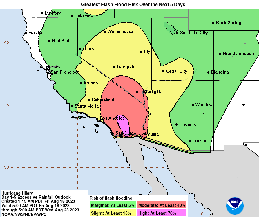
An exceptionally rare D3 high risk now issued. Catastrophic flooding is certainly on the table for some areas of the SW. Excessive Rainfall Discussion NWS Weather Prediction Center College Park MD 358 AM EDT Fri Aug 18 2023 Day 3 Valid 12Z Sun Aug 20 2023 - 12Z Mon Aug 21 2023 ...A HIGH RISK OF EXCESSIVE RAINFALL EXISTS FOR THE PENINSULAR RANGES OF SOUTHERN CALIFORNIA... Portions of the West... The guidance is unanimous in merging Hilary with an upper low stuck near central CA. Normally for a tropical cyclone this would be a problem as convective lows would circle the periphery parallel to 1000-500 hPa thickness lines, which would otherwise turn it more north or north-northeast, but since Hilary should be strongly shearing while moving over cold waters and transitioning to a post-tropical or remnant low in the process, it should have diminishing convection in its vicinity, so this isn't the typical model bias (this time). A large area of precipitable water values of 1.75-2.5" will approach if not exceed all-time time records, so there will be moisture to spare. In the Southwest in particular, flow at 750 hPa is expected to reach or exceed 65 kts, so heavy upslope rains on the atypical sides of the southern Sierra Nevada and Peninsula Ranges of CA are anticipated. If the flow is more southerly than expected due to a slightly more westerly track of Hilary, there's a chance that both sides of the Peninsular Range get heavy rainfall. The NAEFS is indicating IVT values 14.8 sigmas above the mean. Even assuming a non-standard distribution, this is extreme. There is a very real potential for 3" amounts in an hour in this environment. Some of the guidance shows local amounts of 7"+, which would be exceeding rare for the region from a tropical cyclone, potentially unique for Nevada. The 100 year ARI is forecast to be exceeded. If a 7"+ maximum materialized over Mount Charleston Sunday into early Monday, it would challenge Nevada's 24 hour rainfall record, set in 2004. Given the overall uniqueness of this event, chose to upgrade to a High Risk for areas near and east of the Peninsular Ranges of Southern CA.
-
I’ve had 3-5 1”/hr+ events this summer with one 2.54”/hr event. It has been nuts. EH is very vulnerable to flooding given our topography. Before flood control, approximately 1/5 of town would flood annually from the rivers and a lot more would be at risk during any rainfall events if not for our pumping stations.


