WxWatcher007
-
Posts
35,873 -
Joined
-
Last visited
Content Type
Profiles
Blogs
Forums
American Weather
Media Demo
Store
Gallery
Everything posted by WxWatcher007
-
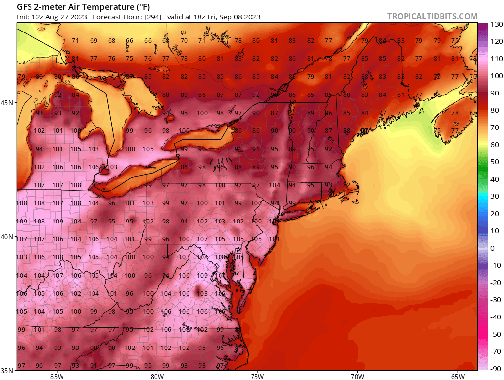
Gotta love the ole American I haven’t followed it much but I figured with some of the discussion a few weeks ago that warmth was on the table in early September. It’s been an exceptional period of heat to our south and west, and while I don’t expect 100 in September I do think we get pretty warm relative to normal for at least a bit.
-
Not boring? That’s a 101 at HFD

-
I’d probably wait until the 00z suite because the models will have data on not just right now but how Idalia evolved over the course of the day.
-
It’s no surprise that the vortex is tilted, and that’ll limit the risk of rapid intensification in the near term. That said I’d watch the development of shallow convection near the center. Sometimes that can be a precursor for greater convective activity that can organize the center. I’m guessing we see it in spurts however given the apparent northerly shear that’s currently tilting Idalia.
-
I know, just a little funny to see. They telegraphed it at 11am by saying it could happen at anytime.
-
WxWatcher007 Peak Season Forecast (Aug 20-Oct 20) Named Storms: 13 (5) Hurricanes: 6 (1) Major Hurricanes: 3 (0) Emily, Franklin (H), Gert, Harold, Idalia
-
That was fast
-
@STILL N OF PIKE It’s lurking for sure, and you can kind of see how that may keep the system sputtering a bit in the Gulf tomorrow, but then the signal for intensification through landfall Tuesday/Wednesday remains.
-
Dropsonde shows center pressure ~995mb
-
Holding at TD 10 at 11am Tropical Depression Ten Discussion Number 4 NWS National Hurricane Center Miami FL AL102023 1000 AM CDT Sun Aug 27 2023 So far this morning, the overall cloud pattern of the tropical cyclone has not become significantly better organized. The small center is partially exposed on GOES-16 visible imagery, and convective banding features are still not very well defined. The current intensity is held at 30 kt for this advisory which is in line with the latest Dvorak Satellite estimates. A NOAA Hurricane Hunter aircraft, flying at around 12000 ft, is near the center of the system taking Doppler radar wind velocity measurements. These data should provide valuable information on the structure of the cyclone for initializing the numerical weather prediction models. The center of the cyclone appears to have been moving in a small clockwise loop overnight and into this morning, and it will probably complete this loop today. The initial motion estimate is now around 090/2 kt. Steering currents should remain weak through today and tonight. Beginning on Monday, a mid-level ridge starts to build near southern Florida and eastward. This evolution should cause a generally northward motion during the next couple of days. In 48 to 72 hours, a mid-level trough dropping into the eastern U.S. will likely induce a turn toward the north-northeast and take the system across the northeast Gulf of Mexico coast on Wednesday. The official forecast track has been nudged to the right of the previous one, but is not quite as far east as the latest corrected consensus, HCCA, prediction. Users are reminded not to focus on the exact forecast track, since strong winds, heavy rains and dangerous storm surges extend well away from the center. The cyclone will be moving over waters of high oceanic heat content over the eastern Gulf of Mexico and within a moist mid- to low-level air mass for the next few days. An upper-tropospheric trough is predicted to develop over the western Gulf of Mexico in 48 to 72 hours. Although this feature could produce some moderate southwesterly vertical wind shear over the system, positive vorticity advection and diffluent upper-level flow to the east of the trough will likely be conducive for strengthening. The official forecast, like the previous one, calls for the cyclone to reach hurricane status over the eastern Gulf of Mexico in 48 to 72 hours. This is at the high end of the latest intensity model guidance. KEY MESSAGES: 1. The depression is forecast to become a hurricane over the eastern Gulf of Mexico, and there is an increasing risk of life-threatening storm surge, flooding from heavy rainfall, and hurricane-force winds along portions of the west coast of Florida and the Florida Panhandle beginning as early as Tuesday. Although it is too soon to specify the exact location and magnitude of these impacts, residents in these areas should monitor updates to the forecast, have their hurricane plan in place, and follow any advice given by local officials. Storm surge and hurricane watches may be required for portions of the Gulf coast of Florida later today. 2. Heavy rainfall is expected across the eastern Yucatan Peninsula and western Cuba and may produce areas of flash and urban flooding and landslides across western Cuba. The depression is forecast to become a tropical storm later today, and tropical storm conditions are expected over portions of the Yucatan Peninsula and extreme western Cuba with tropical storm conditions possible on the Isle of Youth. 3. Scattered flooding from heavy rainfall is likely over in portions of the southeast U.S. by mid to late week. FORECAST POSITIONS AND MAX WINDS INIT 27/1500Z 19.9N 85.8W 30 KT 35 MPH 12H 28/0000Z 19.7N 85.9W 40 KT 45 MPH 24H 28/1200Z 20.6N 85.7W 45 KT 50 MPH 36H 29/0000Z 21.9N 85.5W 50 KT 60 MPH 48H 29/1200Z 24.0N 85.2W 60 KT 70 MPH 60H 30/0000Z 26.2N 85.0W 75 KT 85 MPH 72H 30/1200Z 28.9N 84.0W 80 KT 90 MPH 96H 31/1200Z 33.0N 79.5W 45 KT 50 MPH...INLAND 120H 01/1200Z 34.5N 74.0W 45 KT 50 MPH...OVER WATER $$ Forecaster Pasch
-
995.4mb extrapolated
-
Some evidence of minimal TS intensity on the latest set of obs from recon but it’s still early in the flight.
-
Not really much to say this morning other than for reasons earlier described it looks like the well defined LLC we were all tracking yesterday and overnight is a fragile feature. Not really going to have thoughts on the models and system until recon has had a chance to fully sample the environment and examine the TD.
-
A little west of runs yesterday. Recon will be taking off around 6am and we’ll have a bunch of data going into the models so hopefully the end up with a high confidence forecast.
-
Pressure down to 1001mb according to the NHC.
-
Going to be a stronger GFS run tonight as it had a more organized system near the Yucatán.
-
Certainly possible that continental dry air causes disruption, but I think it’s less of a risk here than usual because there doesn’t look to be enough shear to impart it on a system that should be relatively organized and therefore more resistant to the shear. The upper level trough looks weak in a few days and if anything I think it’ll promote ventilation/outflow. Let’s say it doesn’t though. If future Idalia is able to build an organized core as it enters the Gulf, the outflow should be able to blunt the influence of shear and dry air. I think that’s why models are basically unanimous in having this intensify through landfall. That’s a huge flag to me that this has a higher ceiling. The possibility of land interaction the next 36 hours or so is really critical to the track and intensity forecast.
-
Every other region of the country seeing historic or high end wx this August while every other post in the New England subforum is about a random met nobody has ever met and their middle age social life.
-
You can see on that graphic that it’s still working under the influence of the ULAC. That’s been key to development given the shear in the region. It’s basically working in a pristine TC genesis environment currently—and land is the only thing that could be reasonably expected to slow this down before it lifts into the Gulf.
-
It absolutely has a chance, though I’m not sure if it gets there. NOAA throwing all the recon it has at this one starting tomorrow.
-
Comes with the territory here. We’re on to fall and football season.
-
Tropical Depression Ten Discussion Number 1 NWS National Hurricane Center Miami FL AL102023 400 PM CDT Sat Aug 26 2023 The cloud pattern of the low pressure area located near the northeastern Yucatan Peninsula of Mexico has gradually become better organized today. Radar observations show a circulation has developed, although surface observations indicate that the western semicircle of this circulation is rather weak at this time. Given the increased organization, advisories are being initiated on Tropical Depression Ten. Surface synoptic observations suggest that the current intensity is around 25 kt. The current motion estimate is nearly stationary. There is a weakness in the subtropical ridge to the north of the tropical cyclone, leaving the system in a region of very weak steering flow. The dynamical guidance indicates that the system will remain in weak steering currents for the next 24 to 36 hours, so very little motion is predicted during that period. After that time, a mid-level ridge begins to build to the east of the tropical cyclone. This should cause a generally northward motion in the next 2 to 3 days. Then, a gradual turn to the north-northeast is expected as the system moves along the northwestern periphery of the ridge. The official track forecast is a blend of the simple and corrected dynamical model consensus guidance. The tropical cyclone will be moving over very warm waters with only moderate vertical wind shear anticipated during the next several days. Therefore, gradual strengthening is forecast. The official forecast is similar to the latest LGEM guidance and shows the system becoming a hurricane over the eastern Gulf of Mexico. Users are reminded that there is significant uncertainty in 3-4 day intensity predictions and are urged to monitor changes to future forecasts. KEY MESSAGES: 1. Heavy rainfall from Tropical Depression Ten is expected across the eastern Yucatan Peninsula and western Cuba. The heavy rainfall may produce areas of flash and urban flooding, as well as landslides, across western Cuba. The depression is forecast to become a tropical storm by Sunday, and tropical storm conditions are expected over portions of the Yucatan Peninsula where a Tropical Storm Warning is in effect. Tropical storm conditions are possible over portions of western Cuba within the Tropical Storm Watch area. 2. The depression is forecast to strengthen during the next few days and could become a hurricane over the eastern Gulf of Mexico, bringing a potential of dangerous storm surge, heavy rainfall, and strong winds to portions of the west coast of Florida and the Florida Panhandle by the middle of next week. Heavy rainfall is also likely to spread into portions of the Southeast U.S. by mid to late next week. Although it is too soon to specify the exact location and magnitude of these impacts, residents in these areas should monitor updates to the forecast of this system and ensure that they have their hurricane plan in place. FORECAST POSITIONS AND MAX WINDS INIT 26/2100Z 21.1N 86.1W 25 KT 30 MPH 12H 27/0600Z 21.0N 86.3W 30 KT 35 MPH 24H 27/1800Z 20.9N 86.2W 35 KT 40 MPH 36H 28/0600Z 20.8N 86.1W 40 KT 45 MPH 48H 28/1800Z 22.0N 85.7W 45 KT 50 MPH 60H 29/0600Z 24.0N 85.6W 50 KT 60 MPH 72H 29/1800Z 26.3N 85.3W 65 KT 75 MPH 96H 30/1800Z 31.5N 83.0W 45 KT 50 MPH...INLAND 120H 31/1800Z 35.0N 79.0W 30 KT 35 MPH...INLAND $$ Forecaster Pasch
-
Boring end to summer