bristolri_wx
-
Posts
2,125 -
Joined
-
Last visited
Content Type
Profiles
Blogs
Forums
American Weather
Media Demo
Store
Gallery
Everything posted by bristolri_wx
-
The snow would have been good. But the models lost it somehow.
-
It does seem to have gotten a little crazy in here. At least from my perspective, it's been a good winter. It's been cold, it's snowed, and we've had snow pack for weeks. In East Bay RI that's a rarity, compared to other parts of New England. It will be a little disappointing if we don't get another decent storm before things wind down, but putting things in perspective, it's been the best winter in 10 years here, even if we didn't get a truly big storm between now and when spring truly arrives. As for the next few weeks there will be chances based on the ensembles, but chances are better off away from the coastal plain. Nothing new for this time of the year. As long as we have cold nearby there's chances something will work out, and thankfully Canada has been helpful with their cold exports this year compared to the last few winters.
-
When Keeping It Real Goes Wrong (like this thread)
-
Ugh these maps are terrible... I'd rather see 384 hour op run blizzards and torches.
-
That map could verify with +1 departures and another foot of snow on the ground. Junk!
-

Friday February 6 FROPA / WINDEX small event
bristolri_wx replied to HoarfrostHubb's topic in New England
I think about 4.5” here. Bristol was on the edge of that band for a few hours before it finally rotated east. A nice fresh coat of white paint. -
Friday February 6 FROPA / WINDEX small event
bristolri_wx replied to HoarfrostHubb's topic in New England
Large heavy cotton balls falling out of the sky here. Heaviest stuff so far! -
Friday February 6 FROPA / WINDEX small event
bristolri_wx replied to HoarfrostHubb's topic in New England
Your facts are truthful but your tone is frigging annoying AF. Also heavier stuff is moving east through RI now. This system was always advertised as a winner/loser scenario, with narrow bands of very good snow growth, with mostly meh everywhere else, and the type of stuff that isn't modeled well. Enjoy what you have, this winter has been 10 times better than the last several in RI!!! -
Friday February 6 FROPA / WINDEX small event
bristolri_wx replied to HoarfrostHubb's topic in New England
Congrats Albuquerque? -
There will be another relaxation. It makes sense. It would be harder for one not for one to occur... patterns only last so long in our area.
-
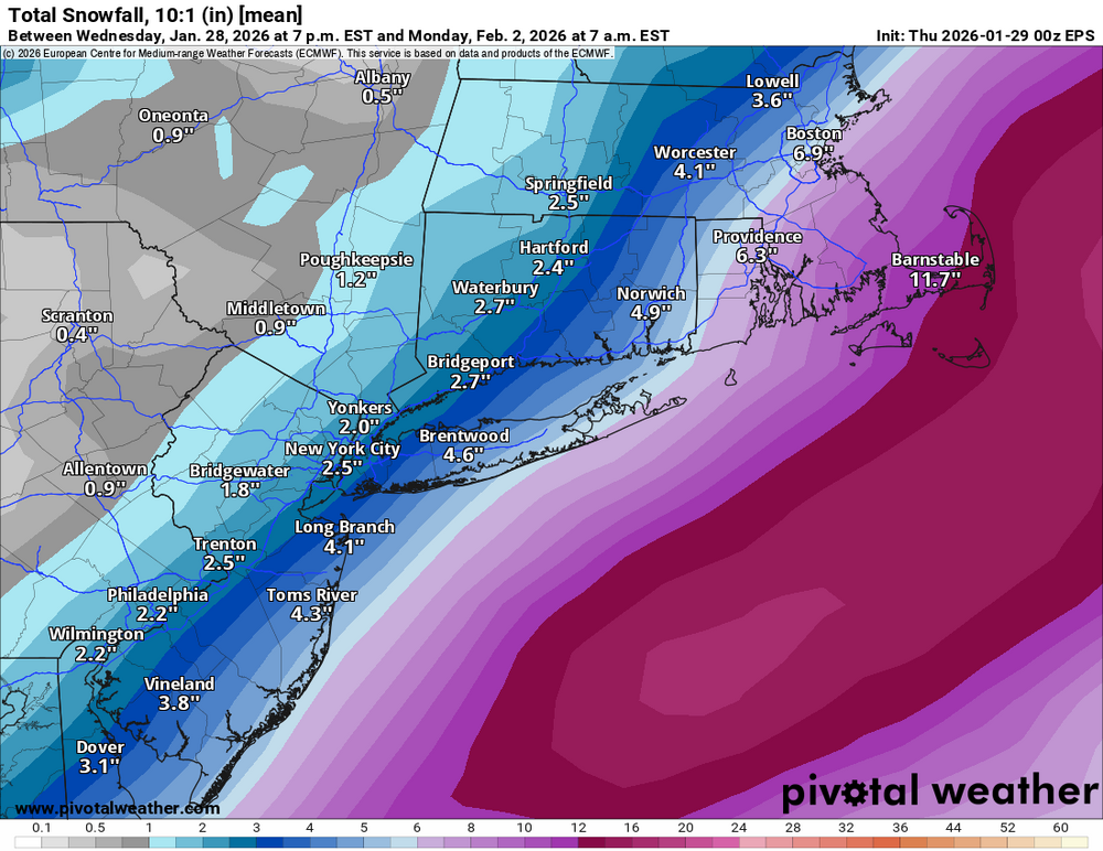
Sure. However that wasn't the context I was going for. 384 hour weenie maps were being posted with doom and gloom comments! While any weather scenario is always on the table, basing an opinion on a forecast outcome on that particular data set was quite silly. That's my point. If we are looking at a 5 day forecast for it to be bone dry, then it's definitely a very possible forecast and weather outcome. Cold air is around. There will be chances that aren't even showing up in the models. They may not work out but there will be trackable systems over the next few weeks.
-
I'm so confused?? Last time I checked in we were getting no meaningful snow or precipitation until April? Isn't that what those 384 HR OP runs were showing???
-
Nothing brings on snow more than no snow in the long range ensemble runs! Seriously, as long as it’s cold, there’s a chance something materializes. I would be more worried if they were showing relaxation like earlier in January, which they not look to be, just moderation of a very anomalous cold pattern. Euro weeklies still look decent in terms of pattern, and they have been pretty good this winter in terms of general 500mb conditions/outcomes…
-
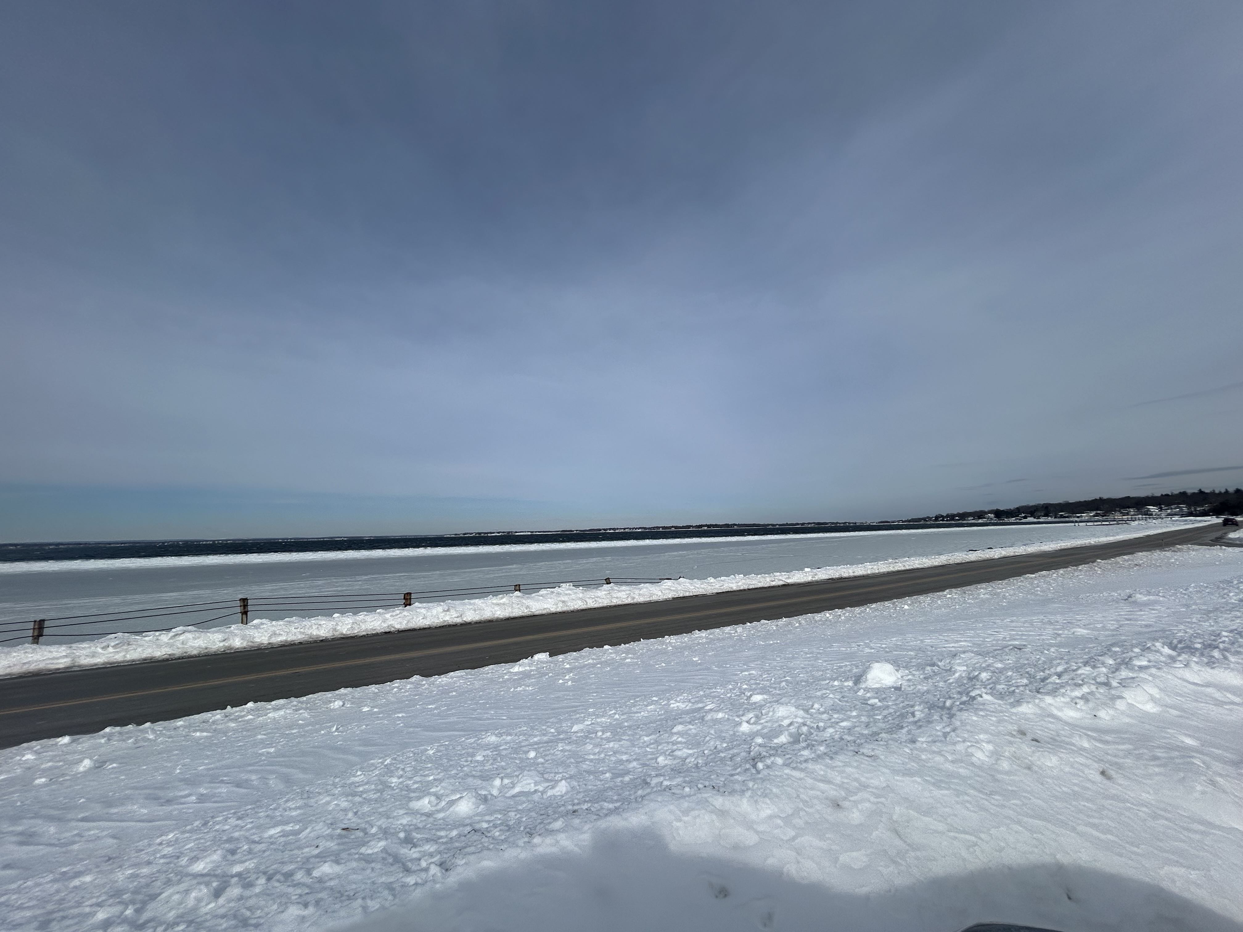
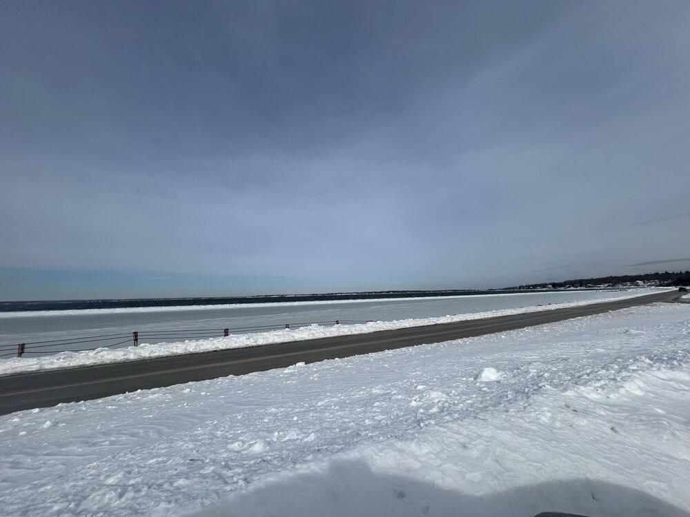
And some freezing of Narragansett Bay… it’s been a while.
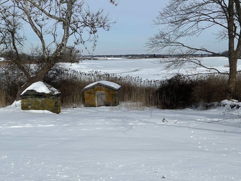
-
Deep winter in Colt State Park in Bristol.
-
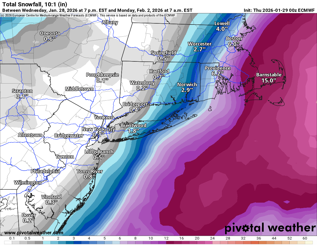
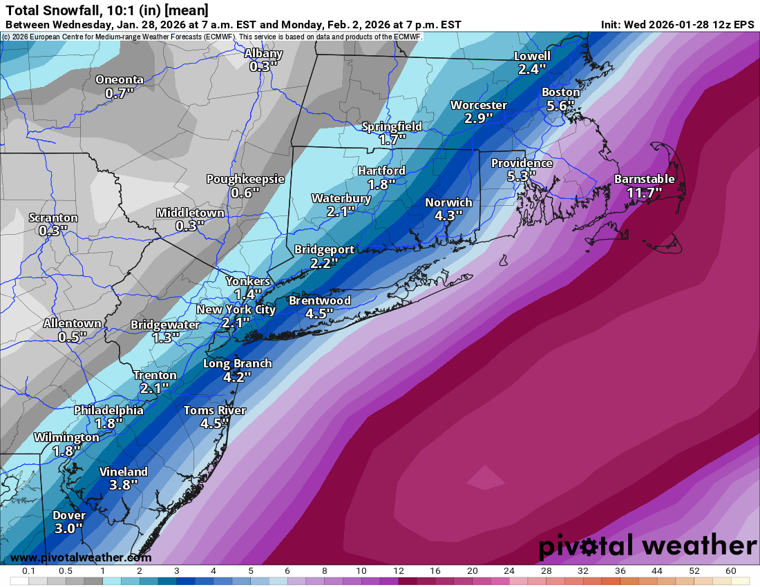
Possible coastal storm centered on Feb 1 2026.
bristolri_wx replied to Typhoon Tip's topic in New England
150 miles north west and this board would still be interested... shit happens... pivotal-weather-ecmwf_full-700hv-nwatl.mp4 -
Possible coastal storm centered on Feb 1 2026.
bristolri_wx replied to Typhoon Tip's topic in New England
Nope, no interesting weather to discuss in this topic 6 days out... shit happens... sometimes the margin of error ends up being a big deal. On to the next threat... G19_sector_eus_GEOCOLOR_240fr_20260201-0914.mp4 -
Possible coastal storm centered on Feb 1 2026.
bristolri_wx replied to Typhoon Tip's topic in New England
Expected snowfall: 0.0" -
Possible coastal storm centered on Feb 1 2026.
bristolri_wx replied to Typhoon Tip's topic in New England
I haven’t seen anything in the last 12 hours that leads me to believe that the forecast is locked in yet. It’s a large complex storm made of moving parts that in some cases haven’t formed yet. The low formation southeast of us is still oscillating to various degrees, which is leading to a wide variety of outcomes, even in the different scenarios that don’t lead to a large snowstorm for us. Impacts in western New England will be low, unless something dramatically changes. However central and eastern NE could be impacted heavily depending on today’s model output. Next 3-4 forecast cycles will probably become more consistent, especially as data sampling of the different parts improve. Most can make their decisions before bedtime this evening. -
Possible coastal storm centered on Feb 1 2026.
bristolri_wx replied to Typhoon Tip's topic in New England

-
Possible coastal storm centered on Feb 1 2026.
bristolri_wx replied to Typhoon Tip's topic in New England
Considering the atmospheric scenario and the number of moving parts, there's a higher risk for this than usual on a 4 day forecast. I truly wouldn't dismiss any scenario for another 48 hours. -
Possible coastal storm centered on Feb 1 2026.
bristolri_wx replied to Typhoon Tip's topic in New England
That's a tight gradient... the ultimate melt storm as visualized...
-
40dbz echoes in that band when it was in your area. Crazy!
-
Had some whiteout conditions for about 10 minutes…