bristolri_wx
-
Posts
2,125 -
Joined
-
Last visited
Content Type
Profiles
Blogs
Forums
American Weather
Media Demo
Store
Gallery
Everything posted by bristolri_wx
-
 Still heavy rain here. Lots-o-street flooding. Looks like it's semi-regenerated in this area a little as that main cluster of heavy rain moved through and swung northeast.
 -
Holy downpours here in Providence!
-
Saturday, July 18, 2026 Thunderstorm/Severe Weather Potential
bristolri_wx replied to weatherwiz's topic in New England
thunder and downpours here for two hours now... these things are moving fast though. -
Saturday, July 18, 2026 Thunderstorm/Severe Weather Potential
bristolri_wx replied to weatherwiz's topic in New England
Wasn’t expecting severe here but we have been getting downpours here on and off for the last two hours as these little clusters of heavy showers move east. -
Saturday, July 18, 2026 Thunderstorm/Severe Weather Potential
bristolri_wx replied to weatherwiz's topic in New England
Round two starting to pop-pop-popcorn…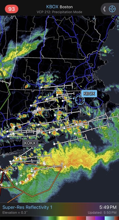
-
Saturday, July 18, 2026 Thunderstorm/Severe Weather Potential
bristolri_wx replied to weatherwiz's topic in New England
Gotta love how that intial heavy cluster of storms will not cross Long Island Sound into CT. Seems like you could be at the beach where it's dry and go swimming and it would pour on you.
-
Smoke... pivotal-weather-hrrr-smoke_viden-us_ne.mp4 pivotal-weather-hrrr-smoke_sfc-us_ne.mp4

-
Hoisting the Sultan Signal: Heavy Rain Event July 5-7
bristolri_wx replied to WxWatcher007's topic in New England
If this storm teaches anyone anything it’s you shouldn’t say a forecast has busted until the storm is actually done. Models were all over the place on QPF, and yes they also had some outrageous amounts that may have not ended up occurring, but it was always showing a 2.5 day event, and different phases or chapters. Areas of rain have been pulsing, regenerating, and dying out for the entire duration of this storm. It also shows how much room for improvement there needs to be for modeling to nail down with better accuracy for these types of weather events. But the common sense forecast didn’t waiver much. There will be some larger numbers reported once things wind down, and the widespread 1-2” with 3-5” isolated spots will not be too far off what was being forecasted in the mid-range. -
Hoisting the Sultan Signal: Heavy Rain Event July 5-7
bristolri_wx replied to WxWatcher007's topic in New England
Seems like another 1-2” of rain over next 24 hours looks to be reasonable for many south of the pike as the storm moves north and the east over the coastal waters. Every model has a different depiction of how it exactly turns up. HREF are juicy but should be taken with a grain of salt, but shows why no one is steining this storm at 5PM on Monday even though precip shield is scattered/ragged on radar at the moment. Someone is going to get a lot of rain though wherever that boundary settles in. -
Hoisting the Sultan Signal: Heavy Rain Event July 5-7
bristolri_wx replied to WxWatcher007's topic in New England
Rain is not expected to really pick up until this evening into tonight for parts of CT, SE MA, and RI when the low to the south of Long Island is expected to continue pushing north. Up towards northern MA, rain may not start until around midnight. With the approaching low, a boundary will also push northward that will clash with high pressure, a PWAT plume with values up to (and even exceeding) 2.0", and a LLJ with winds around 30 kt at 925 mb. This would be a main driver for widespread heavy rainfall along the boundary, which guidance has still struggled to find a more concrete solution to. Rainfall totals between 1-3" are still expected over much of southern New England, with lighter totals expected closer to the NH border. Locally higher totals between 4-6" remain a possibility over parts of CT, RI, and SE MA. Even with the spread in guidance regarding where these totals may be, a number of models still key in on those areas as having the highest risk for these totals. For these reasons, a Flood Watch remains in effect through tomorrow afternoon for our counties in northern CT into RI and SE MA to the Cape. -
Taking the opportunity to take advantage of these “cool” low 80’s temps to get the backyard ready for the 3rd/4th. Can’t believe it’s 81 at 10:45 at night.
-
Think it made it to 97 here today. Was hoping for a sea breeze to kick in but that didn’t happen.
-
Good morning from Colt State Park in Bristol, a hazy 79 degrees with light breeze.
-
You could end up with more, but the showers seem to be of a more scattered nature over the next 24 hours, so it could be more of a hit and miss situation. The HRRR shows 1 - 2" over next 18 hours, and it's been more accurate showing the QPF in short term than some of the other models.
-
On a non-holiday weekday when we need the rain, we can deal with the shitty temps for a day or two if that's what gets us some steady soaking precipitation.
-
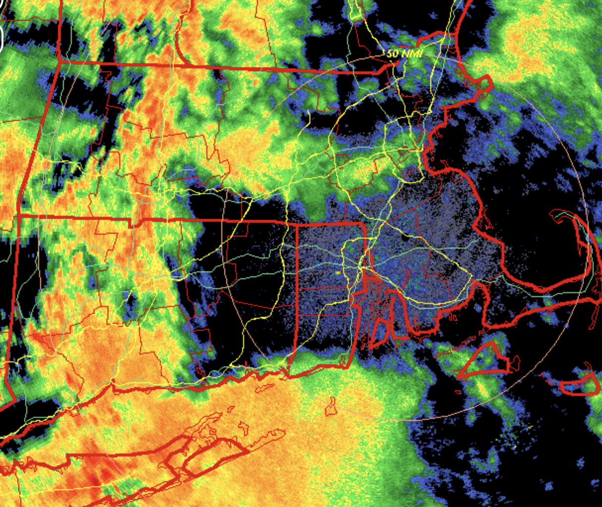
Looks like some lower level dry air or mid level dry air knocking down what’s attempting to fall in SNE? The look on radar between KOKX and KBOX is significant in SNE areas… Glad we are getting some rain regardless!
-
Looks decent as long as you don't believe the GFS - seems to be the dry outlier on QPF... NBM still 1-2" SNE...
-
Hard to beat a day like today in mid June… even got the free parking because we waited until after 5…
-
There’s a coastal flood statement posted in my area… Astronomical high tides? The statement doesn’t mention the potential cause.
-
Just missing out here by 10 miles… I guess I can grill up my Saugy’s without fear of being struck by lightning.
-
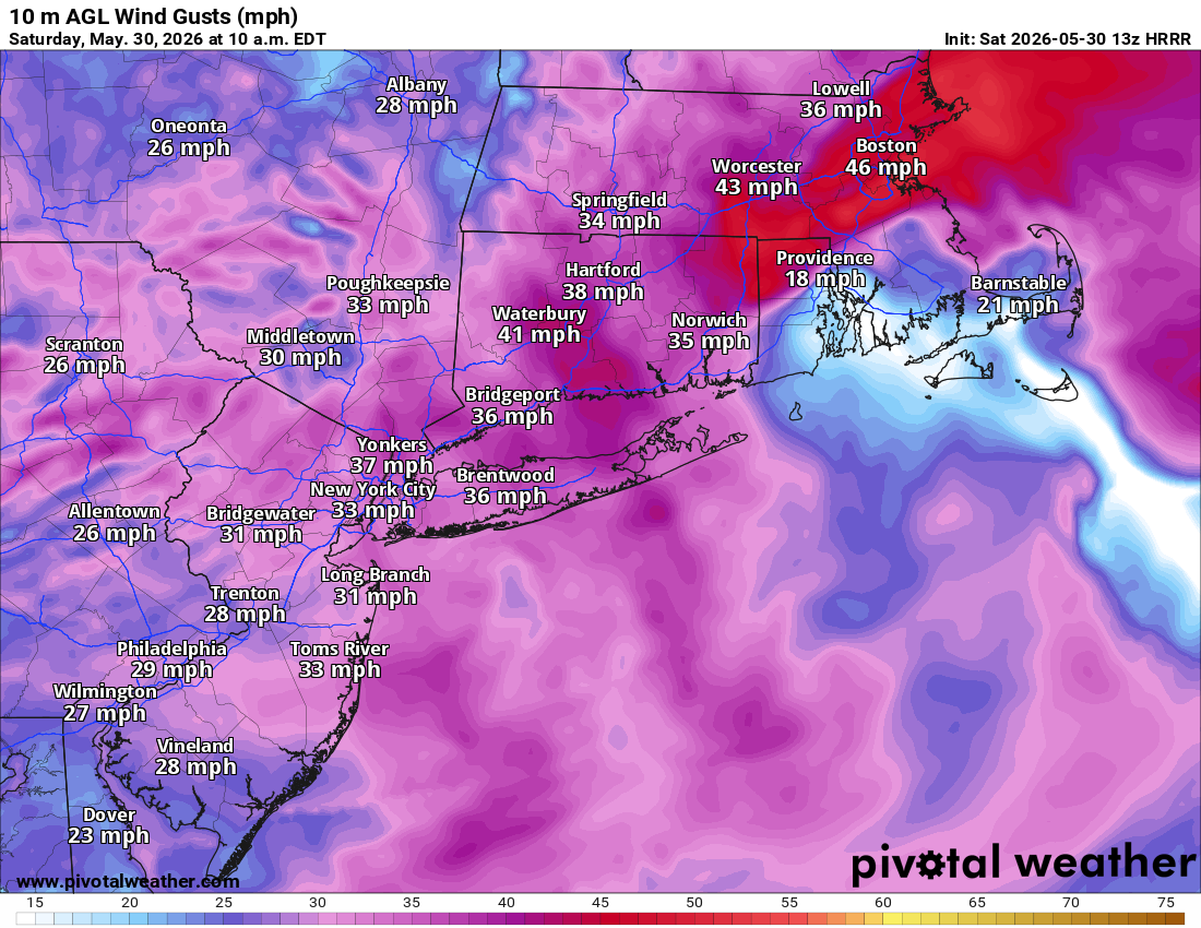
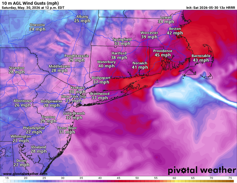
Anomalous Late Spring storm May 30 2026
bristolri_wx replied to HoarfrostHubb's topic in New England
Interesting little bugger lol... G19_sector_ne_GEOCOLOR_240fr_20260530-1040.mp4 -
Anomalous Late Spring storm May 30 2026
bristolri_wx replied to HoarfrostHubb's topic in New England
Trying to figure out why everyone else is talking about wind and I look outside and see leaves barely moving... I guess it will be here in the next hour or two.
-
At least this storm is interesting. Better than 48 hours of drizzle and fog. Of course worse than a 75/55 and sunny Saturday.
-
Looking at guidance I think the storm Fri/Sat will produce more QPF over a wider area than is currently being forecasted.
-
I just did my first cut of the season last week. I've been gradually transitioning my lawn to drought resistant fescue and clover and it's been pretty low maintenance. I don't water or use fertilizer unless I'm planting seed. It's gotten pretty damn dry on occasion but it bounces back much more quickly than when I had more bluegrass to contend with, which would really not deal well with the dry conditions.