bristolri_wx
-
Posts
2,130 -
Joined
-
Last visited
Content Type
Profiles
Blogs
Forums
American Weather
Media Demo
Store
Gallery
Everything posted by bristolri_wx
-

“Cory’s in NYC! Let’s HECS!” Feb. 22-24 Disco
bristolri_wx replied to TheSnowman's topic in New England

-
“Cory’s in NYC! Let’s HECS!” Feb. 22-24 Disco
bristolri_wx replied to TheSnowman's topic in New England
I feel like the Euro holding back is the cause. It's always hard to fully commit to the GFS. Blending the two gets you that number right now. -
“Cory’s in NYC! Let’s HECS!” Feb. 22-24 Disco
bristolri_wx replied to TheSnowman's topic in New England
Looks like they are planning to run hurricane hunter recon all weekend to get extra data for the storm as it's forming. https://www.nhc.noaa.gov/text/MIAREPRPD.shtml https://www.tropicaltidbits.com/recon/ -
“Cory’s in NYC! Let’s HECS!” Feb. 22-24 Disco
bristolri_wx replied to TheSnowman's topic in New England
Brave does use Chromium, which is the basis for Google Chrome, and is the open source project managed by them. Other browsers that use Chromium are Microsoft Edge, Brave, Vivaldi, and Opera (to name a few). Firefox and Safari run separate browser engines... -
“Cory’s in NYC! Let’s HECS!” Feb. 22-24 Disco
bristolri_wx replied to TheSnowman's topic in New England

-
“Cory’s in NYC! Let’s HECS!” Feb. 22-24 Disco
bristolri_wx replied to TheSnowman's topic in New England
Thanks for confirming that @Typhoon Tip is actually AI and not a real person. We have all been wondering this for many years with his long posts, that sometimes wander. Somehow he never runs out of tokens - clearly an AI model ahead of it's time. -
“Cory’s in NYC! Let’s HECS!” Feb. 22-24 Disco
bristolri_wx replied to TheSnowman's topic in New England
-
“Cory’s in NYC! Let’s HECS!” Feb. 22-24 Disco
bristolri_wx replied to TheSnowman's topic in New England
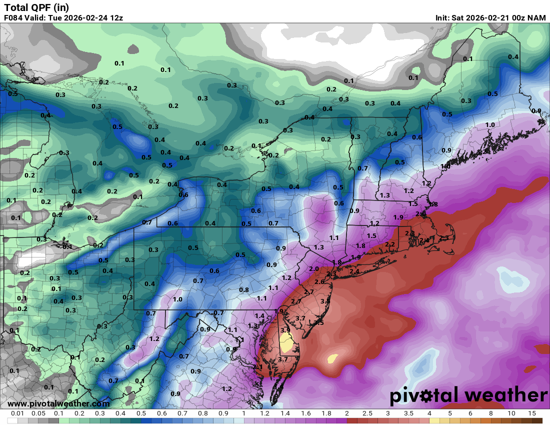
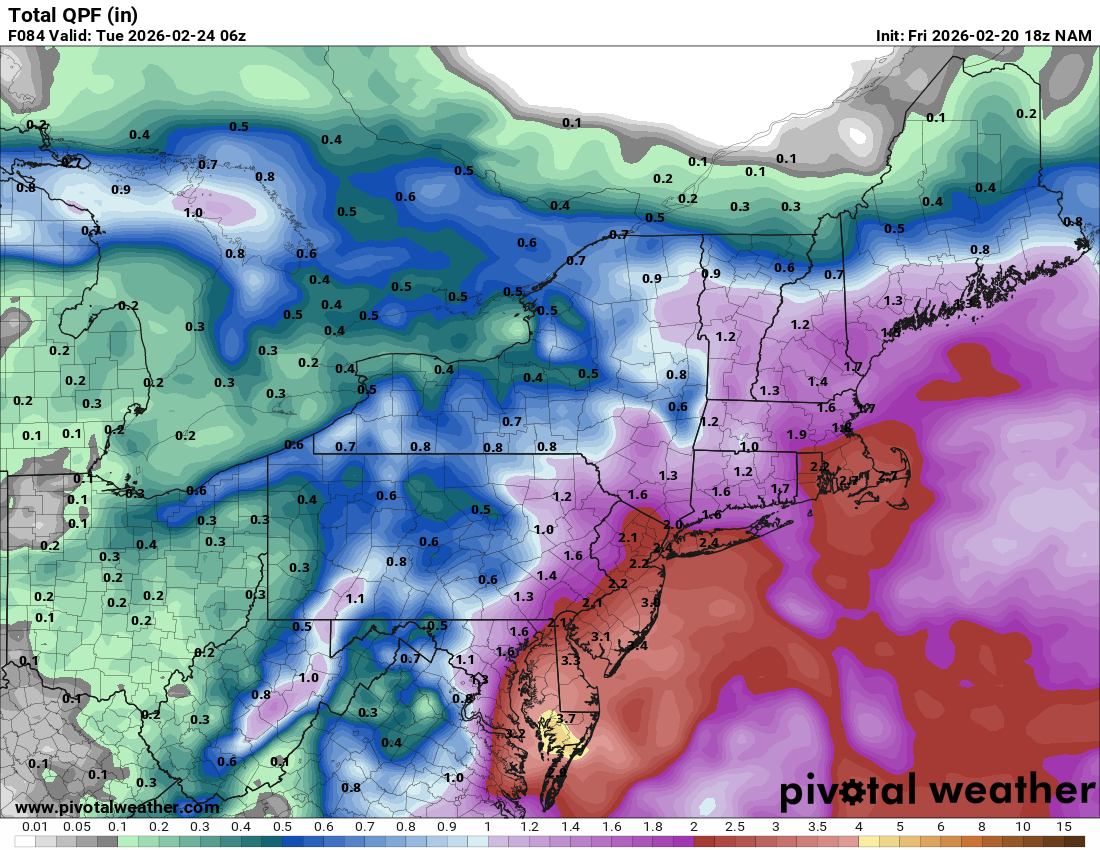
Sorry, Pivotal being annoying and shifting runs when they aren't 100% complete.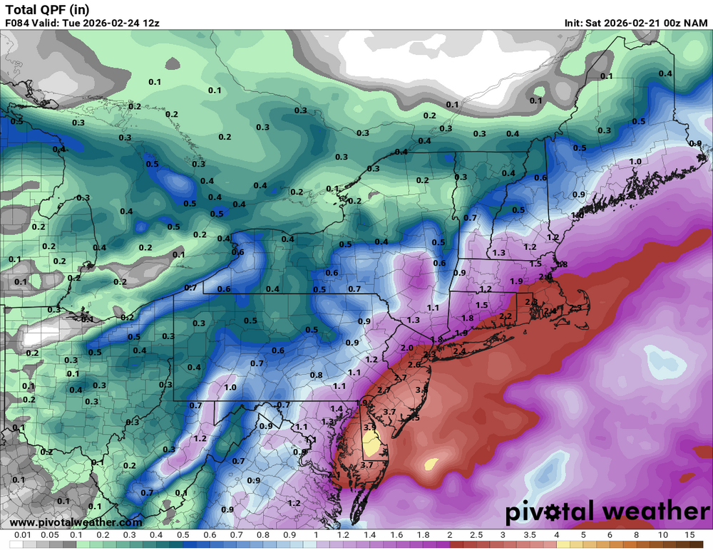
-
“Cory’s in NYC! Let’s HECS!” Feb. 22-24 Disco
bristolri_wx replied to TheSnowman's topic in New England
-
“Cory’s in NYC! Let’s HECS!” Feb. 22-24 Disco
bristolri_wx replied to TheSnowman's topic in New England
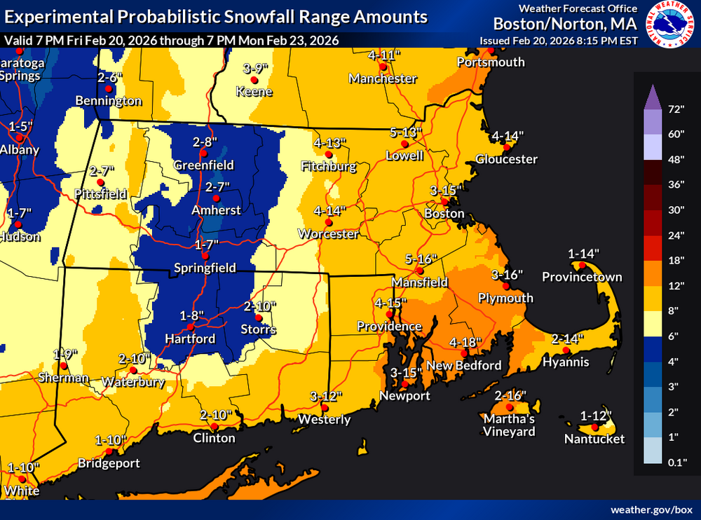
This is definitely more interesting from BOX... not often you see 20% chances of more than 18+.thumb.png.1a4c4d7513ab397a002bfc0e94f0ac8f.png)
-
“Cory’s in NYC! Let’s HECS!” Feb. 22-24 Disco
bristolri_wx replied to TheSnowman's topic in New England
-
“Cory’s in NYC! Let’s HECS!” Feb. 22-24 Disco
bristolri_wx replied to TheSnowman's topic in New England
-
“Cory’s in NYC! Let’s HECS!” Feb. 22-24 Disco
bristolri_wx replied to TheSnowman's topic in New England
LOL love these ranges....
-
“Cory’s in NYC! Let’s HECS!” Feb. 22-24 Disco
bristolri_wx replied to TheSnowman's topic in New England
Regarding @leftymarlins debut post: SKIP: He walked eighteen?! LARRY: It's a league record. SKIP: Struck out eighteen... LARRY: League record. And he hit the Radio Announcer, a Sportswriter, and the Bull Mascot - twice -- also league records -- Joe, the guy's got some serious shit. -
“Cory’s in NYC! Let’s HECS!” Feb. 22-24 Disco
bristolri_wx replied to TheSnowman's topic in New England
We could have both a well managed NOAA/NWS and the other things you mentioned. There's pages and pages of why modeling is shit for east coast snow storms (which falls under NOAA), but there haven't nearly been the amount of resources and coordination done to help improve that. There's definitely efficiencies to be had, but I don't think there's been a lot of well planned resource consolidation. It's been more machete like... -
“Cory’s in NYC! Let’s HECS!” Feb. 22-24 Disco
bristolri_wx replied to TheSnowman's topic in New England
I was trying to avoid going there, but, it's definitely a factor, but not the only factor. I'm trying not to derail the thread... -
“Cory’s in NYC! Let’s HECS!” Feb. 22-24 Disco
bristolri_wx replied to TheSnowman's topic in New England
Unfortunately there's been a general downward trend in the quality of AFD's. I think it's a combination of a lot of younger talent at BOX and organizational changes from above. In the past when a warning level storm was brewing, AFD's would come out more often as data rolled in. Now they only follow the schedule of 3 or 4 per day and sometimes the changes are very minor. It's sad, IMO, they used to be great reads in most cases, and very educational. -
“Cory’s in NYC! Let’s HECS!” Feb. 22-24 Disco
bristolri_wx replied to TheSnowman's topic in New England
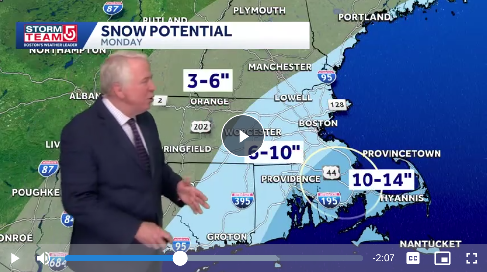
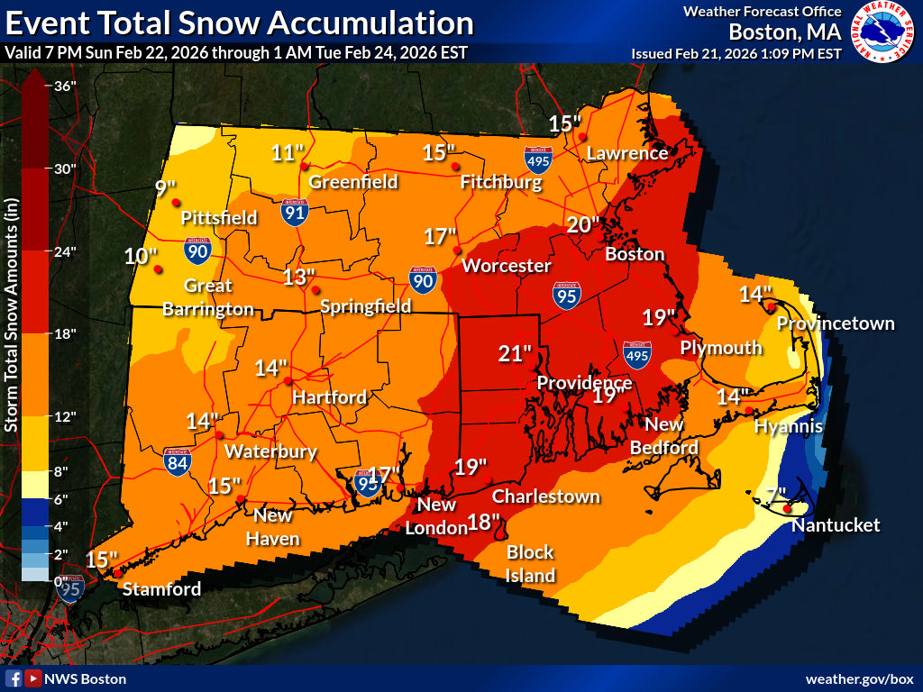
If things stay true, will likely be officially a blizzard at some of the recording sites... 50-75 Knot winds at 925mb from 2AM - 8PM on Monday. That's enough to get the mix downs to 35 MPH at the surface. Jeesh... -
“Cory’s in NYC! Let’s HECS!” Feb. 22-24 Disco
bristolri_wx replied to TheSnowman's topic in New England
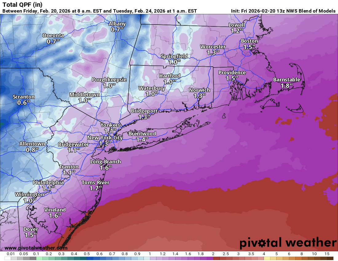
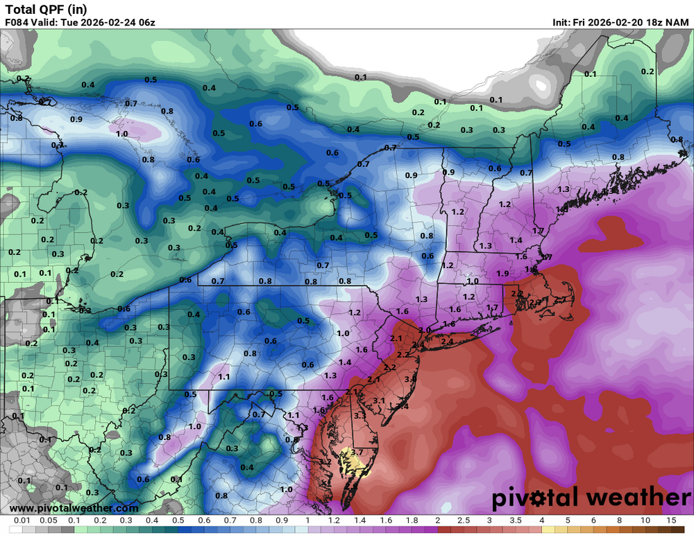
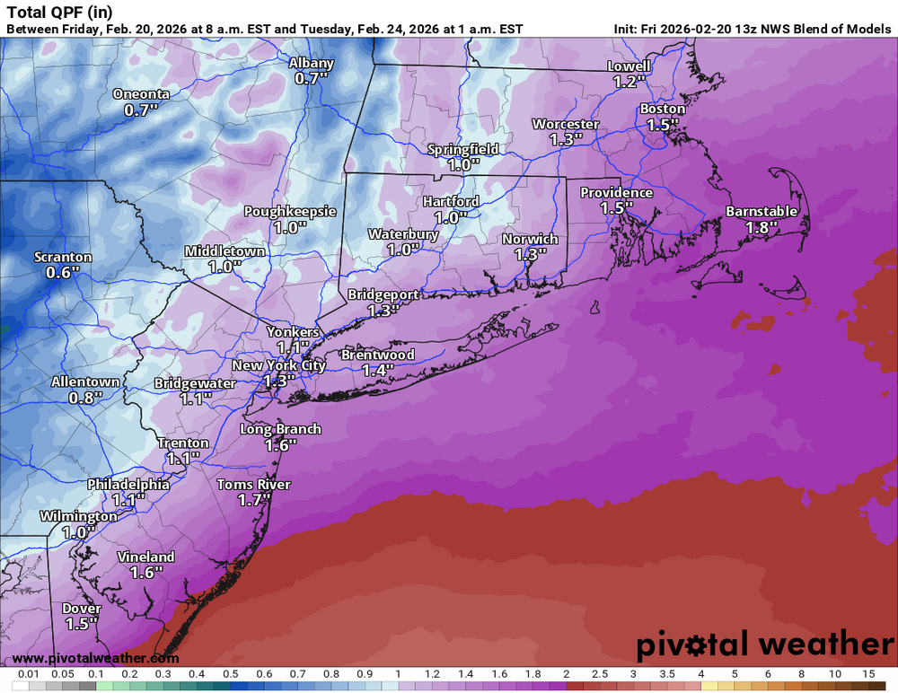
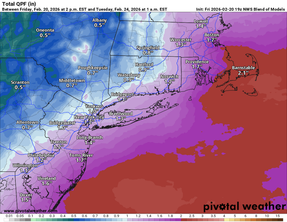
NBM QPF Trend...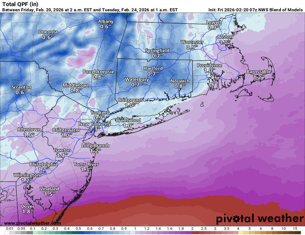
-
“Cory’s in NYC! Let’s HECS!” Feb. 22-24 Disco
bristolri_wx replied to TheSnowman's topic in New England
Thank you for your service. -
Snowing pretty hard in Providence. Starting to stick. Was expecting rain, so not sure when the switchover is supposed to happen. Seems like we may have already gotten more snow than expected...
-
“Cory’s in NYC! Let’s HECS!” Feb. 22-24 Disco
bristolri_wx replied to TheSnowman's topic in New England
I don’t think so. They realized the one they were going to put into production was bad. The MPAS versions are already scoring better verifications…. -
“Cory’s in NYC! Let’s HECS!” Feb. 22-24 Disco
bristolri_wx replied to TheSnowman's topic in New England
Let's not get too excited. We've seen this before this winter, even when it's this close. Let's get two or three runs in a row for a trend. Promising though... I continue to feel like as the resolution of the global models increases there have been increases in error in this type of forecasting of what happens with the sensible weather at the surface, as the input data points have not increased as significantly as the model resolution. Just an opinion from a curious, but somewhat ignorant, model and weather enthusiast. -
Leave at 5 or 6 AM. You will hit snow rather than ZR at the end of your in trip in NYS, at least if the HRRR is true. 18z NAM is a little slower with the snow/sleet/ice.
-
It is not a good model... sell...


.png.5fb7b1a097ef85261eadcda9f453580f.png)