bristolri_wx
-
Posts
2,125 -
Joined
-
Last visited
Content Type
Profiles
Blogs
Forums
American Weather
Media Demo
Store
Gallery
Everything posted by bristolri_wx
-

“Cory’s in NYC! Let’s HECS!” Feb. 22-24 Disco
bristolri_wx replied to TheSnowman's topic in New England
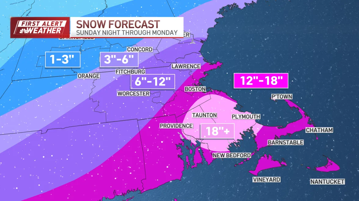
We like our emergencies civil here in RI. -
“Cory’s in NYC! Let’s HECS!” Feb. 22-24 Disco
bristolri_wx replied to TheSnowman's topic in New England
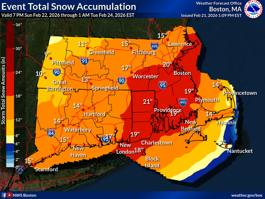
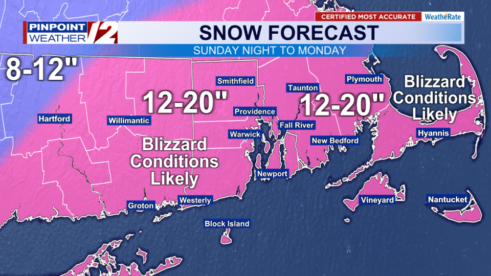
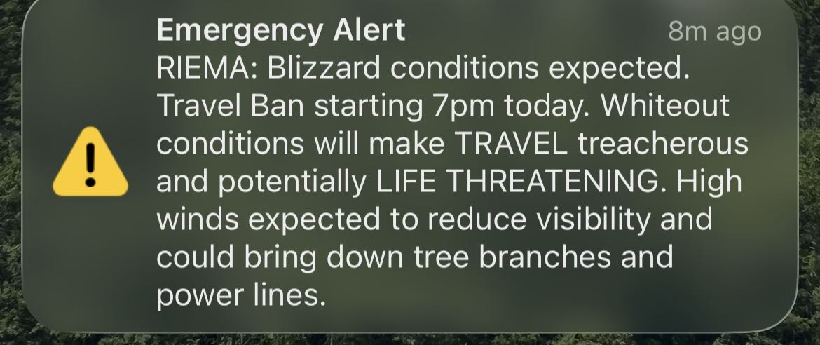
Things got real here got a real emergency alert EAS tones and all on my phone for the Blizzard Warning. Don’t get these often.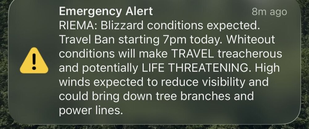
-
“Cory’s in NYC! Let’s HECS!” Feb. 22-24 Disco
bristolri_wx replied to TheSnowman's topic in New England
-
“Cory’s in NYC! Let’s HECS!” Feb. 22-24 Disco
bristolri_wx replied to TheSnowman's topic in New England
I find that they are usually a little overdone on the snowfall output. Trim the PMM numbers by 10-15% and usually have sensible weather. -
“Cory’s in NYC! Let’s HECS!” Feb. 22-24 Disco
bristolri_wx replied to TheSnowman's topic in New England
Yeah seems like noise and locked into a track at this point. -
“Cory’s in NYC! Let’s HECS!” Feb. 22-24 Disco
bristolri_wx replied to TheSnowman's topic in New England
I believe this is the only way you can easily get some sort of output from Google’s WeatherNext 2 model, but this definitely looks fun…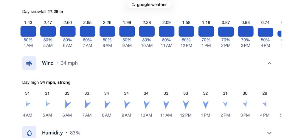
-
“Cory’s in NYC! Let’s HECS!” Feb. 22-24 Disco
bristolri_wx replied to TheSnowman's topic in New England
This would be nice, even if it was only 12 hour forecast! -
“Cory’s in NYC! Let’s HECS!” Feb. 22-24 Disco
bristolri_wx replied to TheSnowman's topic in New England
.thumb.png.f8891ebc5930139c87a5a0daf6c48413.png)
-
“Cory’s in NYC! Let’s HECS!” Feb. 22-24 Disco
bristolri_wx replied to TheSnowman's topic in New England
This site also has the updated MPAS version of the RRFS they are working on, and a nicer view of the HREF's (attached). It's a cool site.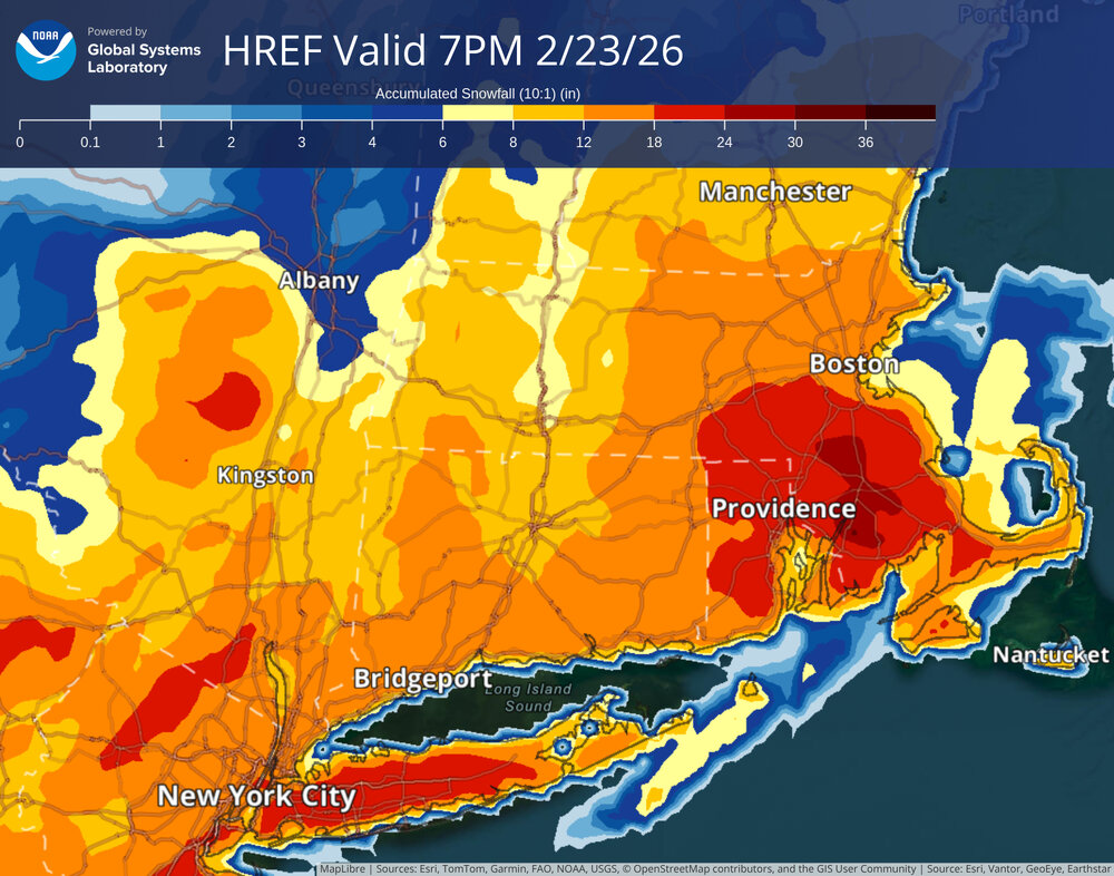
-
“Cory’s in NYC! Let’s HECS!” Feb. 22-24 Disco
bristolri_wx replied to TheSnowman's topic in New England
I feel like some of those models are specifically geared towards ensemble forecasts. You never hear about the NMM or ARW being used on their own as operational runs in forecast discussion. -
“Cory’s in NYC! Let’s HECS!” Feb. 22-24 Disco
bristolri_wx replied to TheSnowman's topic in New England
Only one that I can see that's specific to this storm. Not sure if the one out in the Pacific is going to be adding anything. -
“Cory’s in NYC! Let’s HECS!” Feb. 22-24 Disco
bristolri_wx replied to TheSnowman's topic in New England
? -
“Cory’s in NYC! Let’s HECS!” Feb. 22-24 Disco
bristolri_wx replied to TheSnowman's topic in New England
You may need to purchase a larger computer monitor. -
“Cory’s in NYC! Let’s HECS!” Feb. 22-24 Disco
bristolri_wx replied to TheSnowman's topic in New England
I wouldn't be too concerned about the GFS unless it goes further SE at 12z: All the models should have more data soon they are flying though it right now and the mission is still ongoing: https://www.tropicaltidbits.com/recon/#AF302-10WSA-TRACK62 -
“Cory’s in NYC! Let’s HECS!” Feb. 22-24 Disco
bristolri_wx replied to TheSnowman's topic in New England
National Weenie Service high end 10% probability map. (just realized @Baroclinic Zonebeat me to it)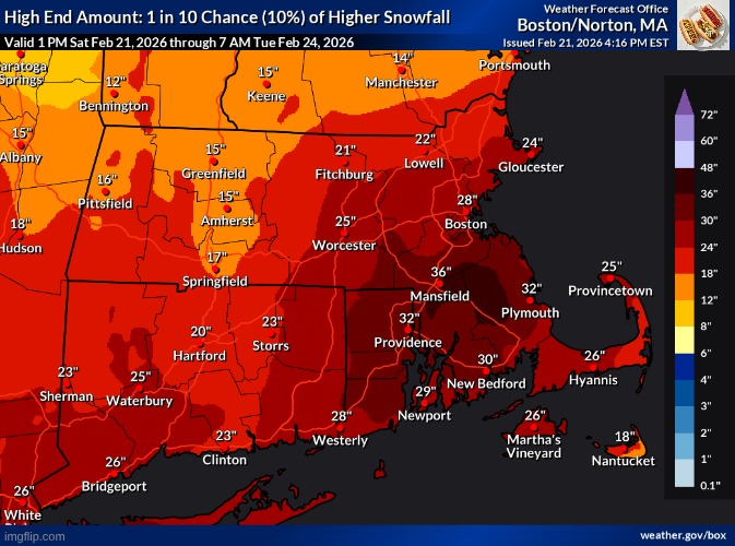
-
“Cory’s in NYC! Let’s HECS!” Feb. 22-24 Disco
bristolri_wx replied to TheSnowman's topic in New England
-
“Cory’s in NYC! Let’s HECS!” Feb. 22-24 Disco
bristolri_wx replied to TheSnowman's topic in New England
Yeah, not trying to spam the forum with maps. Just points of comparison - those seem to be recently updated in the last couple of hours. Some other sites are still showing maps from this morning... -
“Cory’s in NYC! Let’s HECS!” Feb. 22-24 Disco
bristolri_wx replied to TheSnowman's topic in New England
-
“Cory’s in NYC! Let’s HECS!” Feb. 22-24 Disco
bristolri_wx replied to TheSnowman's topic in New England
-
“Cory’s in NYC! Let’s HECS!” Feb. 22-24 Disco
bristolri_wx replied to TheSnowman's topic in New England
-
“Cory’s in NYC! Let’s HECS!” Feb. 22-24 Disco
bristolri_wx replied to TheSnowman's topic in New England

-
“Cory’s in NYC! Let’s HECS!” Feb. 22-24 Disco
bristolri_wx replied to TheSnowman's topic in New England
I feel like the Euro holding back is the cause. It's always hard to fully commit to the GFS. Blending the two gets you that number right now. -
“Cory’s in NYC! Let’s HECS!” Feb. 22-24 Disco
bristolri_wx replied to TheSnowman's topic in New England
Looks like they are planning to run hurricane hunter recon all weekend to get extra data for the storm as it's forming. https://www.nhc.noaa.gov/text/MIAREPRPD.shtml https://www.tropicaltidbits.com/recon/ -
“Cory’s in NYC! Let’s HECS!” Feb. 22-24 Disco
bristolri_wx replied to TheSnowman's topic in New England
Brave does use Chromium, which is the basis for Google Chrome, and is the open source project managed by them. Other browsers that use Chromium are Microsoft Edge, Brave, Vivaldi, and Opera (to name a few). Firefox and Safari run separate browser engines... -
“Cory’s in NYC! Let’s HECS!” Feb. 22-24 Disco
bristolri_wx replied to TheSnowman's topic in New England


.png.d177b9af340b8c608cec3da2a61c015e.png)