hudsonvalley21
-
Posts
4,276 -
Joined
-
Last visited
Content Type
Profiles
Blogs
Forums
American Weather
Media Demo
Store
Gallery
Everything posted by hudsonvalley21
-
The wind will be enhanced by the N/S running Ct and Hudson River canyons. Especially near the West Point area where the mountains right along the River shoot up from sea level to 1,200’. It will be a tough afternoon for the Hudson River bridge crossings especially for those high profile vehicles.
- 212 replies
-
- 2
-

-
- wind damage
- heavy rain
- (and 1 more)
-
Happy thanksgiving all 0.37 in the bucket here today.
-
And that will keep the owl warm
-
23 was the low here. My point and click was 19 and was bumped up to 24 in the afternoon package yesterday.
-
23 here. Point and click forecast low is 24 so we’ll be on the low side. We’ll see how low we go.
-
29 was the low here. Forecast low of 27 for tonight.
-
Wind gusts in the mid 30s here. No mixing down with the squall line (thankfully). 0.38 in the bucket yesterday.
-
Agree with the Ct valley also. I’m about an 1/2 mile from the Hudson and had several gusts here in the upper 30’s
-
Those two locations are in the perfect area for those gusts from the southerly direction. The Hudson River canyon acts like a wind tunnel. I’m about a1/2 mile from the river and had several gusts in the upper 30’s
-
Eta and/or Theta remnant potential Wed-Sun Nov 11-15, 2020
hudsonvalley21 replied to wdrag's topic in New York City Metro
0.67 in the bucket so far today. Currently light rain 64/63 -
A streamer hit here around 7 am and gave a quick coating, quickly melted. Occasional flurries still.
-
Just had a quick coating from a streamer at my elevation of 125’. Current radar has good coverage for the interior this morning.
-
Beautiful !!!
-
Agree, it was a beautiful morning. Standing outside with sunny blue skies hearing the water and small pieces of ice falling out of the trees from the melting.
-
There was an issue with fog over this way too but it was spotty. Maybe it had to do with the snow cover and that was elevation dependent. Overnight low of 24.
-
Flash freeze caught everyone off guard. That unexpected light shower around 6pm set the stage.
-
DCA: +0.8 NYC: +1.0 BOS: +0.8 ORD: +0.4 ATL: +0.7 IAH: +1.2 DEN: +1.6 PHX: +2.2 SEA: +1.3 Snowfall DCA : 16.3 NYC : 30.4 BOS : 44.5 ORD : 39.7 DTW : 48.2 BUF : 87.9 DEN : 61.1 BTV : 83.2 SEA : 6.8
-
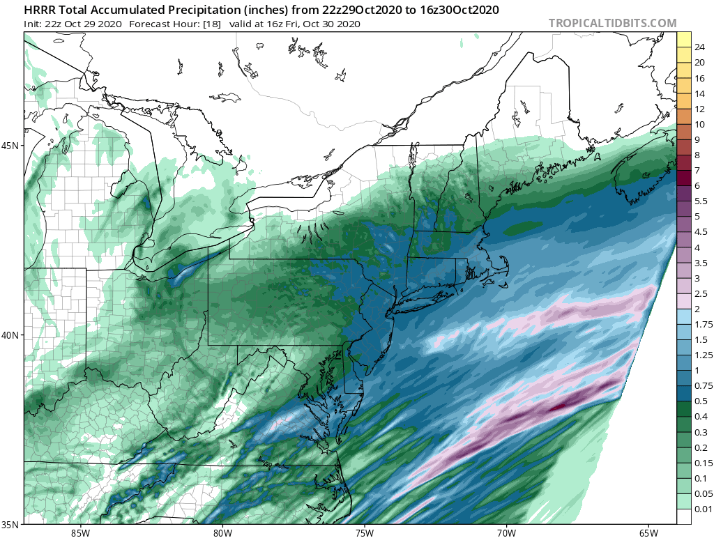
1.94 in the bucket for the event.
-
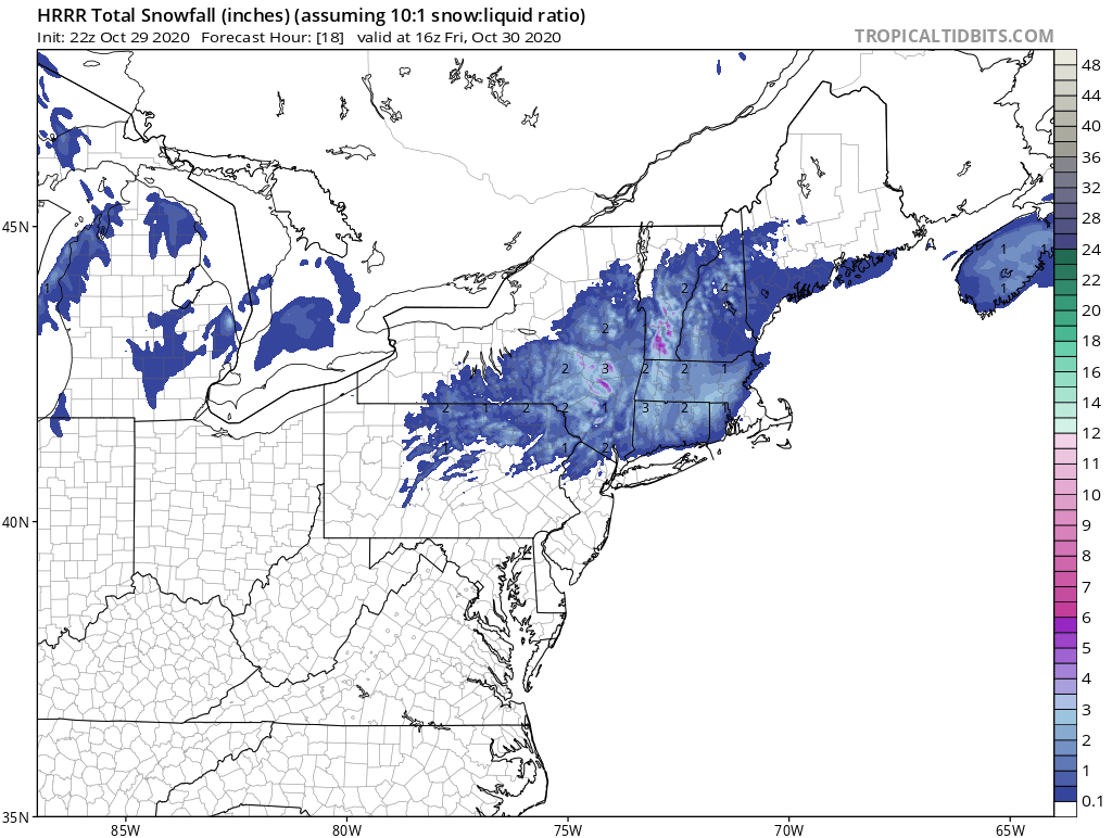
remnants of zeta and potential first flakes for some areas
hudsonvalley21 replied to forkyfork's topic in New York City Metro
Event total 1.94. Trace of snow for my area on cars and grassy surfaces. -
33/32 here sticking to the grass and cars, roads are wet. Huge flakes falling here too. Point and click forecast has a low of 24 for tonight. First hard freeze, got to disconnect the garden hose from the spigot.
-
remnants of zeta and potential first flakes for some areas
hudsonvalley21 replied to forkyfork's topic in New York City Metro
33/32 moderate snow with light accumulation on grass and cars. Roads wet. Point and click forecast has a low of 24 for tonight. Definitely a taste of late fall. -
remnants of zeta and potential first flakes for some areas
hudsonvalley21 replied to forkyfork's topic in New York City Metro
35/35 with white rain at my elevation of 125’. -
35/35 with flakes mixing in now at my elevation of 125’.
-
remnants of zeta and potential first flakes for some areas
hudsonvalley21 replied to forkyfork's topic in New York City Metro

-
46/46 currently with 1.39 in the bucket so far today.