

FallsLake
-
Posts
6,318 -
Joined
-
Last visited
Content Type
Profiles
Blogs
Forums
American Weather
Media Demo
Store
Gallery
Everything posted by FallsLake
-
Finally at hr 48 it's snow at RDU! The line for snow/ice/rain down towards Fayetteville and up towards Rock Mount.
-
It's (now) at least a major ice storm for many (including Triangle folks).
-
Just the normal crap we have endure tracking winter storms for our area....lol I mean my area (...you're in Europe!). You need to move back to fully feel the pain again.
-
RGEM looks great. Looks like it confines the snow to NC northward, It has more north/south p-type cutoff zones allowing places farther east (like Rocky Mount) to get some initial snow. It only goes out to hour 54, but at that time it looks like good snowfall everywhere north from just north of Charlotte to south Wake to Rocky Mount. Below that line is a sleet fest.
-
The 6z GFS has nothing past the VA/NC boarder. Big drop in total precip and coverage. I was about to post the snow map but I'm having issues uploading.
-
Definitely weaker. Looks to scoot that low faster out to sea.
-
For RDU folks, the 6z NAM was an improvement (maybe). The 0z had almost all of Wake in the 2" range (kuchera). You had to get into Chatham and northern Durham to see anything approaching 5". The 6z NAM pushes the 5-6" snows into northern Wake over into all of Durham. Funny but a little less in south central Chatham. Looks a little more south to north with the ranges compared to the 0z with its west to east cutoff zones. Dealing with freezing rain, looks like warning criteria ice for everybody; but it is less (lots of .5" totals compared to last run with over .80"). Also there was a shift east and south of the freezing rain. Folks in Johnson and Harnett counties would get warning criteria amounts.
-
Anything greater that .5" can get real bad. Again it only take .25" to warrant a Winter Storm criteria.
-
Yeah, its got .82" of freezing rain at RDU.
-
He's talking about car tops not the ground.
-
Think we'll have any issues with ice? NAM at face values would say we have a decent ice event.
-
Hey CR, Look at how the 850 temps are trying to move back SW from Canada. https://www.tropicaltidbits.com/analysis/models/?model=ecmwf&region=us&pkg=T850&runtime=2018120612&fh=96 Click 4x back for "Prev. Run" A few move movements back and we have a much better cold air feed.
-
I believe the FV3 just gave me my highest fantasy snow totals for this event. I had another run a few days back that gave me 20"; this gives me 24". Now if I can just get 8" I'll be real happy...
-
I disagree with the last one. We are aware of the forecast but we still go into Denial.
-
The FV3-GFS... and heck the rest of the op models as well.
-
We need to pray this model is correct. .....we need to see the NAM come back on board.
-
Out to 96 and it would barely stay all snow at RDU; with the back side band coming through.
-
I sure hope so. (we've said this way too many times but) This next run is huge.
-
For Charlotte and RDU folks, it was a shift south.
-
I'll take the Canadian as well; especially with that back end snow.
-
At 66 it looks like CAD is a little more pronounce.
-
At this point in the game you have to give more weight over the op models (at least I do). Looks like a ice storm. All we need is .25" to reach Winter Storm criteria.
-
Piedmont ice storm. You would be lucky with the sleet. The Triangle goes from snow to freezing rain.
-
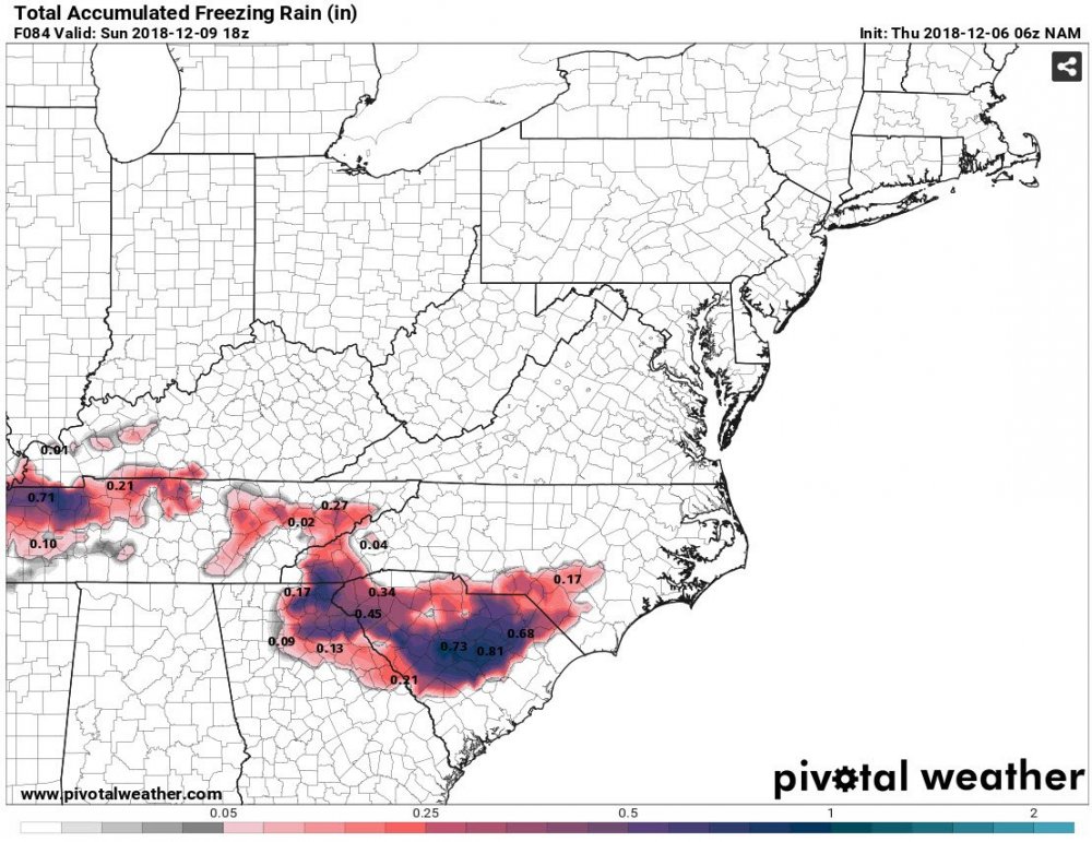
6z NAM freezing rain. And this only goes to hr 84. Lots of precip still occurring and I would think this ice would move up towards central/east NC.
-
Not sure if it was last year or the year before that, we had a storm modeled with high amounts throughout the Triangle (and down east). The models failed to see the warm nose and many folks SE of our location saw a lot of rain mixture. The NAM did see this late in the game but most folks ignored it. **I think we need to pay more attention to the short term models from this point on.


