Jump to content

FallsLake

Members
  • Posts

    6,317
  • Joined

  • Last visited

Everything posted by FallsLake
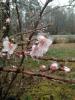
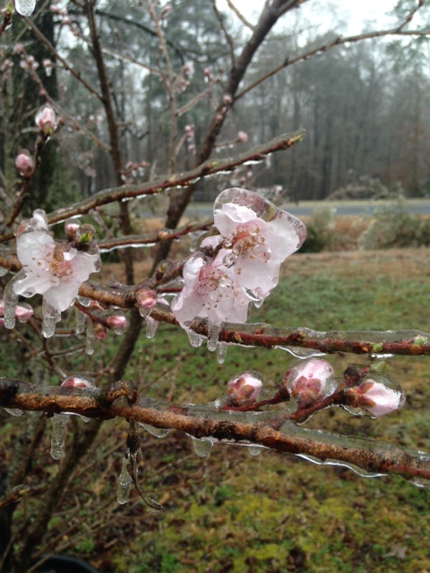
  1. Plus you have to take into account that as frozen precip (snow/sleet) melts it takes heat from the air. It's the opposite of freezing rain which adds heat as it freezes. Edit: I didn't read your last line
  2. I love this radar: https://weather.cod.edu/satrad/nexrad/index.php?type=RAX-N0C-1-24
  3. We need to get the temp down a few more degrees. I'm at 35 and looks like mostly sleet right now.
  4. Man definitely trying to switch to snow.
  5. I got that and a few snow flakes mixing in.
  6. ^^That would be funny to end up getting the two big winter storms in December and March, but basically nothing in January and February.
  7. And to your point, this will occur late night into early morning (low insolation). All we can do now is wait, and track the southward push of dew points and radar.
  8. If anybody gets anything substantial it would be your area and northward. Problem is we need colder temps to make a big ice storm. 30/31/32 doesn't do it. We need temps down into the 20s. But who knows, these setups have over performed (with cold) in the past.
  9. As weather weenies, we could ride the coldest model until the end. Here's the HRW WRF-NSSL. It would have RDU under frozen/freezing precip for 16 hours:
  10. Yeah, as jjwxman said this will be a minor event. If we get some light glaze on the car tops it's a win. At least we had something to track. Been such a boring winter after the December storm.
  11. The 18z HRRR has some nice sleet returns for the Triangle at hour 36. But it never gets dew points (and consequently surface temps) below freezing. It will be very interesting tomorrow to see how far the dew points get pushed southwards from the north. This will be the key thing to track.
  12. Still a go from RAH. Wouldn't be a big event, but at least something: .SHORT TERM /TUESDAY NIGHT THROUGH THURSDAY/... As of 315 PM Monday... ...Continued threat of light icing and a wintry mixture across the interior and northern Piedmont late Tuesday night into Wednesday morning... A strong and cold 1038 hPa high pressure system will move into the PA/NY region Tuesday night and weaken as it pushed off the New England coast late Wednesday. The high is transient but located in a favorable location to establish a CAD regime late Tuesday that will extend into Thursday. Dry air with surface dew points in the teens will extend south from the DC area across eastern VA into eastern NC on Tuesday afternoon. At the same time, a strong upper level trough will exit the western U.S. and move into the Central Plains as a 100+ kt jet develops over TX and moves northeast on Wednesday. A strengthening low and mid level southerly flow will moisten the atmosphere and provide lift across central NC late Tuesday through Wednesday night providing periods of precipitation. As the low level flow strengthens ahead of the approaching upper level trough, isentropic lift will increase primarily in the 295 to 300K layer resulting in a region of largely low and mid level ascent. This results in area of warm advection precipitation that will overspread the region from southwest to northeast between midnight and daybreak Wednesday morning. Forecast soundings suggest that the deep layer moisture and ascent will be confined below 600 hPa. Given this and the strong warm nose that develops at 800 hPa Wednesday morning with a southwest flow at 50 kts, don`t expect much snow although a few flakes could mix in toward the VA border around midnight. The precipitation will produce some wet bulb cooling as the surface layer becomes saturated. Not surprisingly the NAM is the coolest guidance with the wet bulb freezing line pushing south into northern Richmond, Cumberland and western Wilson counties which should serve as the farthest extent of any freezing rain potential. The GFS is notably warmer in the surface layer Given the GFS is notably warmer at the surface and similar in the partials. Will lean toward the cooler NAM solution given its skill to handle these patterns more skillfully. This will support a changeover from rain to freezing rain as temperatures fall to 32 or 31 in the damming region from Albemarle to Raleigh to Warrenton northwestward. Given the marginal surface temperature, the light precipitation amounts, some lulls in the precipitation and moderate temperatures ahead of the event, expect ice accumulations will be limited and mainly confined to locations near and north of I-85 where a light glaze is possible with radial ice accumulations of 0.05 inches or less. Temperatures will moderate ever so slightly After sunrise on Wednesday, and any freezing rain will diminish from south to north and end during the mid morning. Lows will range in the 31 to 32 range in the northern Piedmont and the mid 30s elsewhere. A well established CAD regime will remain in place on Wednesday and Wednesday night with periods of light rain continuing. Highs on Wednesday will range in the mid 30s across the Triad and in the mid to upper 40s across the Sandhills and southern Coastal Plain. Temperatures will be steady or rise a degree or two on Wednesday night under overcast skies and periods of light rain, drizzle and mist. Most NWP systems blast the CAD away on Thursday with the exception of the NAM. GFS MOS provides a high of 66 in GSO on Thursday and 77 at FAY. While the CAD should weaken, given the pattern and the lack of a well defined erosion mechanism, still feel it will remain in place longer and more resilient than much of the guidance says. Will undercut guidance and go with highs in the lower 50s in the Triad to the upper 60s southeast. Huge bust potential with the temperature forecast so stay tuned. &&
  13. Elevated areas will do ok, but I bet you the biggest winners are folks in the north NC foothills and west VA folks. This is the area that may see the lowest temps and longer duration below freezing.
  14. Of course I'm riding the model that shows the best chance of wintery precip. 12z HRW WRF-NSSL:
  15. A little bit colder for the Triangle as well. At hour 42 all of Wake County under some kind of freezing/frozen precip. At hour 45 mid to upper Wake still wintery. Edit: then at hour 48 all of wake back to freezing rain. Definitely a (slightly) colder run.
  16. Could be. With dew points in the teens it would take some time to moisten the column. I'll be interested to see what 12z shows; which is coming up soon.
  17. Funny thing about the 6z NAM, it was actually colder at the surface (..dew points) then 0z. There was just less precip to start the event. So we're starting to get the colder look, we need to also focus on the start time/amounts of precip.
  18. Sure did. It shows a lot less for us but a little more for NE Ga and SC. The 0z NAM run matched up well with the CMC (maybe it goes back at 12z). CMC:
  19. Not a big event, but at least it's something. From RAH: .SHORT TERM /TUESDAY THROUGH WEDNESDAY/... As of 256 AM Monday... ...Some threat of light icing and even wintry mixture increasing over the Piedmont (damming region) late Tuesday and Tuesday night... A strong (1040 mb) and chilly high pressure is forecast to be located over the Great Lakes early Tuesday. This high pressure is forecast to progressively move east to a favorable position for CAD into our damming region Tuesday night (PA/NY state extending strongly south into NC/SC and northeast GA). This occurs as yet another storm system develops over the NW Gulf of Mexico and begins to track NE toward the TN Valley region Wednesday. Timing of the precipitation will be critical as to the P-Type for Tuesday afternoon into the early evening, before warming aloft overwhelms the region from the south. This is a favorable pattern for a winter storm for our region; however, it appears the significant precipitation will arrive Tuesday night and Wednesday, after the warming aloft will be well underway. For now, we will forecast a cloudy and chilly day on Tuesday. There will be a chance of light precipitation during the afternoon in the west and north. Top down and Partial Thicknesses support a mixture of sleet and rain to start Tuesday afternoon with highs in the mid to upper 30s in the Piedmont. Since the precipitation is expected to be light and temperatures above freezing, no impacts are expected. As the precipitation becomes more widespread in the western and northern Piedmont by nightfall or during the evening, the temperatures are expected to fall to around or slightly below 32 in much of the Piedmont (strong evaporative cooling), especially along and NW of a line from Albemarle to Raleigh to Warrenton. A mixture of freezing rain and sleet (through around midnight - before the warm nose aloft arrives - give or take a few hours either side of midnight) may lead to the need for a Winter Weather Advisory in the Piedmont. Remember, roads and the ground has been warmer than normal due to the warm February thus far, so winter storm criteria is not expected. It appears that the main issues would most likely be with bridges and overpasses etc... and during the nighttime hours on Tuesday night. Lows around 30 or 31 NW and N Piedmont, 32 or so along the line from Albemarle to Raleigh to Warrenton, and above freezing (mid 30s) across much of the southern and eastern areas of the Southern Piedmont, Sandhills, and Coastal Plain. The model blended QPF is around 0.25 to 0.40 in the Piedmont Tuesday night through 12z/Wed. Amounts are less to the east with 0.10 to near 0.25 in the Fayetteville, Goldsboro, and Rocky Mount areas through 12z, which would be rain in this case. The amount of frozen/freezing precipitation from 00z/WED through 12z/WED (overnight Tuesday) is expected to be limited to the Piedmont, and the farther NW the higher the PROB of some accumulation. For now, we will carry the potential for a light coating of snow/sleet (less than 1/8 inch of sleet or 1/2 inch of snow) before the change to freezing rain/rain over the Triad and into the Triangle, up to a tenth of an inch or freezing rain can be expected through 12z/Wednesday. On Wednesday, the CAD will linger but the warm nose aloft will gradually eat away at the cold air at the surface. Progressively warmer rain processes will allow warming safely above freezing by late morning. Highs generally mid to upper 30s NW-N Piedmont ranging into the upper 40s SE (These highs will take all day to reach at near 00z/Thu). We will carry a mixture of rain/freezing rain between 12z and 15z, transitioning to rain in the Piedmont. Rain elsewhere. Any freezing rain will be self limiting as the rain falls at a higher rate and the rain falls through a progressively warmer column. &&
  20. 12z NAM at hour 51 has dew points in the upper teens in VA, low 20s across northern NC, mid 20s across N. SC and S. NC, and 20s to near 30 for a large part of SC and mid to N. Ga. We really want this to be about a category colder if your looking for a widespread ice storm. Of course there are many other things to think about, but if you have a strong established CAD (classic) I've always noticed you want dew points in the teens for my particular area. Western areas work a little differently but even there the lower the dew points in VA (..say low teens) the better. CAD can overperform with strength and cold. Just something to look for....
  21. The FV3 came in a little colder for Tuesday (goes along with CMC). Looks like western and northern parts of NC, then up inti VA have a shot of seeing some wintery precip. We shouldn't get to excited. From RAH: Another disturbance and CAD event is expected to effect the area Tuesday afternoon/evening into Wednesday, with lingering affects into Thursday. This will result in rain spreading into the area Tuesday afternoon/evening into Wednesday, with lingering chances for precip into Thursday. A strong 1035+ surface high to the north/northeast will extend south/southwestward into central NC Tuesday into Wednesday before shifting eastward and well offshore by Wednesday night. Meanwhile, a complex low pressure system will approach from the southwest on Tuesday, with precip spreading into the on Tuesday afternoon/evening. Models have trended colder with low level thickness values/thermal profiles across central NC on Tuesday evening/night. In fact we may see a period of rain/mixed with snow across the Piedmont Tuesday night. However, no impacts are expected at this time, with temps expected to remain just above freezing during this time frame. As the warm moisture air continues surge into the area Tuesday night/early Wednesday morning expect any snow mixing in will turn to all rain thanks the the associated warm nose. We will need to keep a close eye on this time frame (Tuesday night into early Wednesday) as wet bulb temps are right around freezing. Given this have lowered temps Tuesday night into Wednesday, with lows Wednesday morning in the lower to mid 30s across the Piedmont to the upper 30s across the south. Highs Wednesday during the daytime are expected to range from the mid to upper 30s NW (maybe a bit too warm still) to the lower 50s far SE (very late in the day too).
  22. Yep, if I was in NW NC up towards your area I would start looking at this closely. Even down towards my area there could be some brief mixing; which I would call a win.
  23. 12z GFS coming in a little colder. Looks like some mixed snow for N. NC up into VA. Maybe even a significant event for NW NC into VA.
×
×
  • Create New...