

FallsLake
-
Posts
6,318 -
Joined
-
Last visited
Content Type
Profiles
Blogs
Forums
American Weather
Media Demo
Store
Gallery
Everything posted by FallsLake
-
Just checked the generator and it's working fine. I'll start filling 5 gallon drums late Tuesday if it looks like it'll directly affect my area. The weather wienie in myself would love for this to hit Wilmington and then plow right for RDU. But the logical part of me says keep this away. I went through Fran and not having power for a couple of weeks sucks.
-
Don't normally post here because much of the discussion is out of my knowledge level. But I do know that each week we pass (with cold, cool, average, or even not blazing temps) towards early September minimum is crucial. So just looking at the 6z GFS, it doesn't look that bad for surface temps. 850 temps do show pushes of much above normal temps but surface temps are at or just above freezing (more reasonable). So I think the big question is cloud cover; but again the farther into August we can get the lower the sun angel and the less affect of clear skies. https://www.tropicaltidbits.com/analysis/models/?model=gfs&region=nhem&pkg=T2m&runtime=2018072906&fh=0
-
Sure haven't. If anybody has any info it would be nice to know he's at least ok.
-
I hope nothing serious has happened. Otherwise I hope he comes back. He's one of the big knowledgeable posters. When everybody contributes, incredible amounts of weather information flows from this site. He's part of that...
-
I agree. He hasn't responded in over two weeks. Was there any issues on this site; like arguments with other posters? If not, it would be nice to check (if possible).
-
I'll take a sleet storm. Just have to get enough to make it relevant. I've said this 10 times in the past, but my favorite storm of all time was the 1996 January storm. Got 6" of mostly sleet which was amazing. Stayed cold afterwards and a week later had a huge freezing rain event. Even the January storm of last year was great (to me). That was nearly 5" of sleet and snow.
-
Yep, officially 6.1". They had 1.2 before this storm and now the from Dec 1st total is 7.3. Below are totals for the last two days: WEATHER ITEM OBSERVED TIME RECORD YEAR NORMAL DEPARTURE LAST VALUE (LST) VALUE VALUE FROM YEAR NORMAL .................................................................. <THIS IS FOR YESTERDAY> SNOWFALL (IN) YESTERDAY 0.2 3.0 2000 0.1 0.1 0.0 MONTH TO DATE 7.0 1.6 5.4 0.5 SINCE DEC 1 7.3 2.2 5.1 0.5 SINCE JUL 1 7.3 2.3 5.0 0.5 SNOW DEPTH 6 <And here is Wednesday> SNOWFALL (IN) YESTERDAY 5.9 R 4.0 1946 0.1 5.8 0.0 MONTH TO DATE 6.8 1.5 5.3 0.5 SINCE DEC 1 7.1 2.1 5.0 0.5 SINCE JUL 1 7.1 2.2 4.9 0.5
-
I think their official snow amount will be 6.1". They received .2 after midnight yesterday: **for some reason I can't past right now.
-
Where's pack?
-
It's hard living in this area. We're just cold enough to have a shot at most east coast winter storms, but end up falling short most times. We have a another potential shot at getting something (ice) Monday. Again, the cosmos has to be in line. But because we have a shot, we'll track each model run.
-
Terrible for my location. That band has dissipated coming out of Durham and I think northern Wake may get the shaft on this. Will probably get some accumulations but not very much. I guess I shouldn't be complaining, but it's going to hurt see the snow map with higher numbers to my west and east. Oh well done venting...
-
Pack it's on your door step. RAH thinks you may be in one of the sweat spots with 2-3"
-
Yeah, I'm disappointed. Just looked at the Euro and it's just cold and dry for RDU for the next 10 days. We may get some kind of clipper (..never modeled well) give us something but the big storm signal has slipped away. Way out at 10 days it has some kind of system, but that's fantasy range. For folks in the deep south, this might be a good pattern for you. Any waves that do pass to the south could give you some rare wintery preicp.
-
The December to Remember 7th-8th blue turd winter threat thread.
FallsLake replied to lilj4425's topic in Southeastern States
Mostly sleet again, some flakes mixing in (34.1). After looking at the latest RAP, this might be what I get for the majority of the event. Lots of frames where I'm in the "purple". -
The December to Remember 7th-8th blue turd winter threat thread.
FallsLake replied to lilj4425's topic in Southeastern States
The latest RAP is ever so colder for areas to the east. RDU is going to be on the line for some of the heaver amounts (...or should I say rates). -
The December to Remember 7th-8th blue turd winter threat thread.
FallsLake replied to lilj4425's topic in Southeastern States
0z NAM hour 21: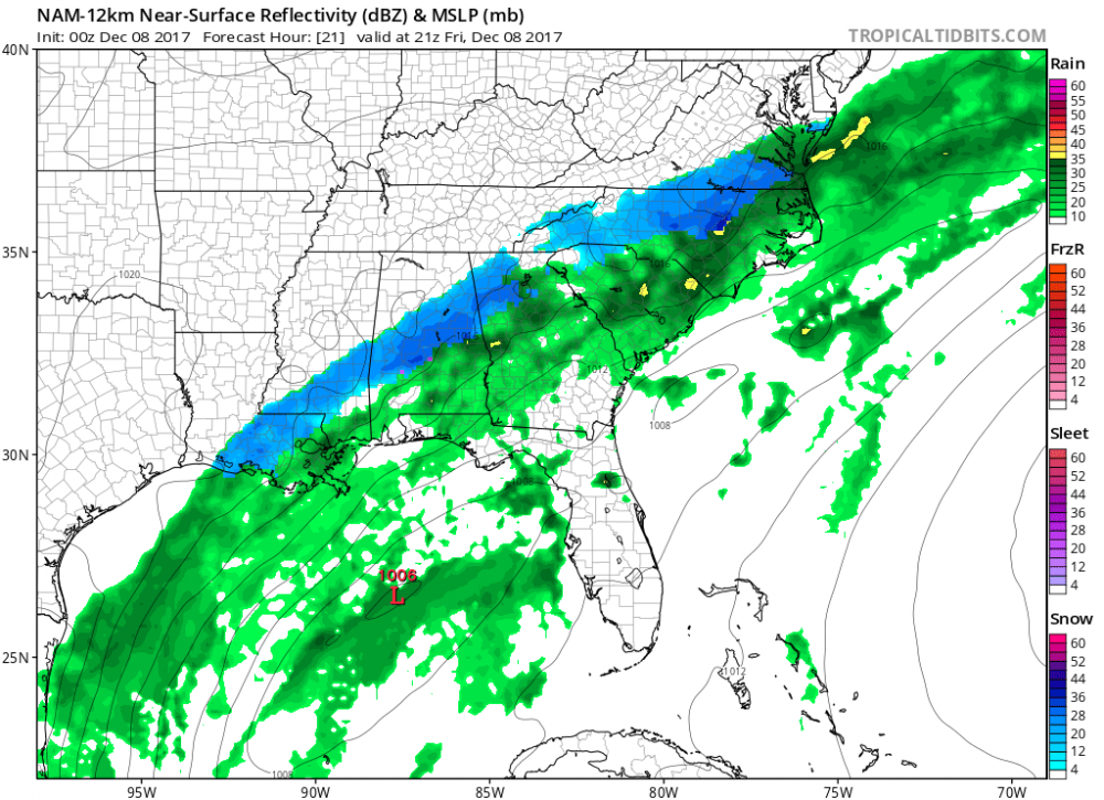
-
The December to Remember 7th-8th blue turd winter threat thread.
FallsLake replied to lilj4425's topic in Southeastern States
Oz NAM better for RDU. Looks like it will flip between snow and rain with heaver rates. -
The December to Remember 7th-8th blue turd winter threat thread.
FallsLake replied to lilj4425's topic in Southeastern States
Dealing with the last couple of runs of the HRRR, it backed off on the intensity of precip which then backed off on the cooling. The latest 0z increase precip rates some which then also increases mixing; particularly around RDU. So basically if you want snow, you need heavy precip to occur. -
The December to Remember 7th-8th blue turd winter threat thread.
FallsLake replied to lilj4425's topic in Southeastern States
Latest RAP(20z) is out and it continues to show RDU getting hit hard. Hour 19 to correspond to the past post with hour 20: -
The December to Remember 7th-8th blue turd winter threat thread.
FallsLake replied to lilj4425's topic in Southeastern States
Here's the latest RAP at hour 20: -
The December to Remember 7th-8th blue turd winter threat thread.
FallsLake replied to lilj4425's topic in Southeastern States
I'm really pulling for the HRRR. It along with the RAP look better for our area: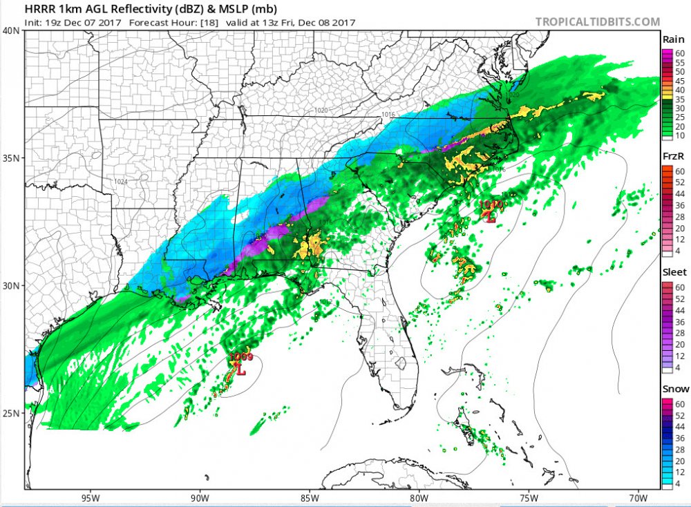
-
The December to Remember 7th-8th blue turd winter threat thread.
FallsLake replied to lilj4425's topic in Southeastern States
For us RDU folks we need to hope that the 3Km NAM has the right idea about snow on the back end: -
The December to Remember 7th-8th blue turd winter threat thread.
FallsLake replied to lilj4425's topic in Southeastern States
The euro would be nice; particularly for the RDU folks. It also shows potential events in the LR. http://wx.graphics/models/ecmwf/ecmwf_usa.php -
The December to Remember 7th-8th blue turd winter threat thread.
FallsLake replied to lilj4425's topic in Southeastern States
Elizabeth Gardner from WRAL. http://www.wral.com/weather/video/17167486/ -
The December to Remember 7th-8th blue turd winter threat thread.
FallsLake replied to lilj4425's topic in Southeastern States
If we can get a dusting or a half inch of slush, consider that a victory. Here's RAH's discussion from last night: .SHORT TERM /FRIDAY THROUGH SATURDAY/... As of 425 AM Thursday... ...Some wet snow is still possilbe across portions of Central NC Friday night and early Saturday although accumulations will be limited... An amplifying trough extending from eastern Canada southwest through the Great Lakes/Ohio Valley into Texas on Friday morning will shift east and approach the Southeast coast by Saturday evening. At the surface, a stationary front extending from northern FL northeast just off the Southeast coast lingers through Saturday with a couple of surface waves of low pressure developing and riding up along the front. A secondary cold front with a surge of slightly colder and drier air settles into VA and evntually northern NC from the north on Friday. The persistent southwesterly flow aloft originating in the western Gulf of Mexico with deep moisture including precipitable water values of 1.5 inches or more and multiple disturbances riding northeast will produce a long ribbon of precipitation across the northern Gulf to the Southeast coast. As disturbances aloft move up the coast near the baroclinic zone off the coast, the precipitation shield will buckle northwest across most of the central NC including the Piedmont on Friday and Friday night. The most widespread precipitation and greatest precipitation amounts will be across the coast with 72-hour model consensus QPF amounts ranging around 1.5 inches in the southern Coastal Plain near Goldsboro, with around an inch from Southern Pines northeast to near Raleigh up to Roanoke Rapids. There will be a sharp gradient in the precipitation amounts across the northwestern edge of the precipitation shield with amounts of 0.1 to 0.25 in the Triad. While anticipating the precipitation amounts across the northwestern colder edge of the precipitation shield is challenging enough, handling the mixing with/change to wet snow and then accumulation potential is problematic. The big picture using pattern recognition screams that a lack of a strong cold/dry high pressure system in a favorable position prohibits a higher impact snow accumulation event. What is more likely are narrow, southwest-northeast elongated snow islands where a cold enough boundary layer meets the precipitation axis and produces some snow accumulations. Partial thickness values and forecast BUFR soundings suggest precipitation on Friday will generally be a cold rain as snow falling aloft melts as it enters a warmer boundary layer where air temps are in the mid to upper 30s in the lowest few thousand feet. With time during the day, the warmth in the boundary layer will cool and toward evening, the precipitation across the interior Piedmont will increasingly mix with and then change to snow overnight with the wet snow area expanding southeast. It typically only takes a wrinkle or two to sabotage snow forecast in central NC or to decrease the snow accumulation efficiency, and there are a lot of potential issues with this event including a lack of cold/dry air, a warm boundary layer, warm ground temperatures and questions about how far northwest the precipitation will extend. In the end, we still expect some light snow accumulations, certainly less than an inch and generally a dusting, will occur west of U.S. Route 1, mainly across elevated and grassy locations. The greatest amounts will likely occur in the I-85 corridor from Burlington northeast to the VA border. It is not out of the question that a couple hour burst of heavier precipitation rates could produce some localized greater amounts up to an inch or possibly two, but that is a low likelihood outcome. The precipitation will end from west to west Saturday morning, perhaps lingering into the early afternoon near the I-85 corridor as some light rain. Highs on Friday will only be in the lower 40s (may stay in the upper 30s in a few spots) with lows Friday night in the 30 to 36 range by Saturday morning. It`ll be chilly on Saturday with highs in the lower 40s. -Blaes &&


