

FallsLake
-
Posts
6,318 -
Joined
-
Last visited
Content Type
Profiles
Blogs
Forums
American Weather
Media Demo
Store
Gallery
Everything posted by FallsLake
-
The December to Remember 7th-8th blue turd winter threat thread.
FallsLake replied to lilj4425's topic in Southeastern States
My grid forecast. even with the better model runs this morning, I would take this and run: Friday Night Rain and snow likely before 1am, then a chance of snow. Cloudy, with a low around 32. Light and variable wind. Chance of precipitation is 60%. New snow accumulation of less than a half inch possible. Saturday A chance of snow, mixing with rain after 10am, then gradually ending. Partly sunny, with a high near 42. Light and variable wind becoming northwest around 5 mph in the afternoon. Chance of precipitation is 30%. New snow accumulation of less than a half inch possible. -
The December to Remember 7th-8th blue turd winter threat thread.
FallsLake replied to lilj4425's topic in Southeastern States
From RAH: .LONG TERM /FRIDAY THROUGH WEDNESDAY/... As of 305 PM Wednesday... ...Increasing chance of snow across portions of Central NC between midnight and 7 AM Saturday, with some accumulation on elevated and grassy surfaces possible... Friday and Friday Night: Central NC will be under the influence of deep southwesterly flow aloft as a strong upper level trough to the west swings eastward toward the region. Disturbances in the flow aloft will move over the area, resulting in periods of heavier precipitation. At the surface, Central NC will be sandwiched between the stalled front off the Mid-Atlantic coast and high pressure ridging eastward from the west. With the high in an unfavorable location, the best push of cold air will likely get hung up along the mountains. Expect much of the precipitation to fall as rain, especially early on. Despite the delayed CAA, strong lift in a saturated dendritic growth zone will likely result in precipitation rates strong enough for snow to occur where temperatures are in the 32-36 degree range. This will be an event where the cold air is chasing the precipitation, thus expect most of the precipitation to fall as liquid. Liquid equivalent precipitation totals will range from less than a quarter of an inch in the northwest to nearly 1.75 inches in the southeast. Given the warm ground and boundary layer, snow will have a difficult time accumulating except for on elevated and grassy surfaces and under high precipitation rates. Generally less than an inch of snow is expected at this time, primarily between midnight and 7 AM Saturday. Best chances for accumulating snow along a line from Lexington to Burlington to Roanoke Rapids, generally be along and west of US-1. Highs on Friday in the low to mid 40s with overnight lows in the upper 20s NW to mid 30s SE. Temps are not expected to fall below freezing in the Triad until after midnight. Saturday through Wednesday: As the strong upper disturbance swings through the region Saturday morning, the main precipitation axis will shift east of the area. At the surface, in the wake of the disturbance aloft, west-northwest flow will advect strong cold air into Central NC ahead of a secondary strong vort max aloft diving southward over the area. Saturday and Sunday will be the coldest days Central NC has had in a while, with highs in the low to mid 40s and overnight lows in the low to mid 20s (possibly dipping below 20 in outlying areas Sunday night). Generally dry weather expected for the remainder of the period although a few sprinkles/flurries early next week cannot be ruled out. Temperatures will moderate a bit Monday and Tuesday before another cold front moves through the area. && -
The December to Remember 7th-8th blue turd winter threat thread.
FallsLake replied to lilj4425's topic in Southeastern States
Here's the NAM at hour 75 (Kuchera):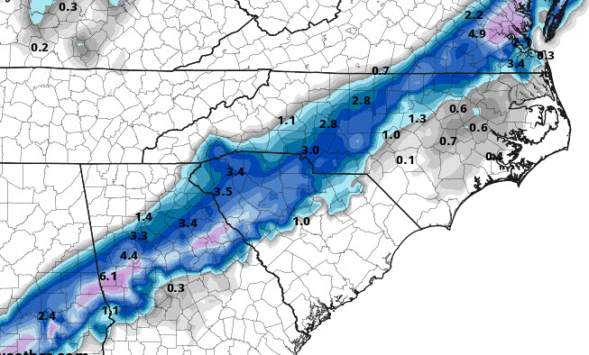
-
The December to Remember 7th-8th blue turd winter threat thread.
FallsLake replied to lilj4425's topic in Southeastern States
I'm nor sure they updated their long range (which includes Friday onwards). .SHORT TERM /THURSDAY AND THURSDAY NIGHT/... As of 110 PM Wednesday... Forecast remains nearly unchanged with a persistent southwesterly flow aloft, deep moisture, and multiple disturbances riding northeast over a baroclinic zone off the southeast coast. Light rain is expected on Thursday and Thursday night across the Coastal Plain and Sandhills, mainly south and east of Raleigh. With colder air working into the region, there is a chance that some of the precipitation will mix with or change to snow. It`s important to note that the pattern suggests an active period with widespread precipitation across coastal NC and decreasing amounts and coverage to the north and west in the more climatologically colder region of the northwest Piedmont. In addition, there is no well defined surface high to support the delivery of cold and dry air into central NC to support more than a low end event. Still, partial thickness values and forecast BUFR soundings support some wet snow across the northwest and northern Piedmont including the Triad area Thursday night with surface temperatures dropping into the 32 to 36 range. But given these areas are on the northwest fringe of the precipitation shield and PoPs are in only the chance range, no snow accumulation is expected. && .LONG TERM /FRIDAY THROUGH TUESDAY/... As of 430 AM Wednesday... ...Potential continues for some wet snow Friday night and very early Saturday although the potential for accumulating snow is limited... As disturbances aloft move up the coast Friday, the precipitation shield will buckle northwest across most of the central NC including the Piedmont on Friday and Friday night with the most widespread precipitation and greatest precipitation amounts to the south and east of Raleigh. The precipitation will shift east late Friday night and Saturday morning with just some lingering, light spotty precipitation across the Coastal Plain expected early Saturday. A better chance for wet snow is expected Friday night and early Saturday morning across much of the Piedmont including the Triad and Triangle areas when the air mass will be a little colder. Air temperatures will fall into the lower 30s in these areas by Saturday morning which could support some light accumulations, on the order of a dusting, mainly across elevated and grassy locations in the general region of the I-85 corridor from Burlington northeast to the VA border. The warm boundary layer and ground temperatures combined with the limited precipitation amounts in the cold enough for snow areas should limit the amount, extent, and impact of snow accumulations. Highs on Thursday will range in the mid 40s with lows Thursday night in the 31 to 38 range. Highs on Friday will only in the lower 40s (may stay in the upper 30s in a few spots) with lows Friday night reaching 28 to 35 by Saturday morning. Cully on Saturday with highs in the lower to mid 40s. Another potent short wave trough and potent lobe of vorticity will swing through the mid-Atlantic late Saturday and early Sunday. This feature will bring some enhanced cloud cover although moisture appears limited enough to preclude any precipitation. A northwest flow develops behind the trough on Sunday and continues into late Monday with dry and below normal temperatures. Another impressive trough approaches on Tuesday with a southwesterly flow ahead of the system that should allow temperatures to moderate and could bring some spotty precipitation before temperatures crash behind the trough on Tuesday night into Wednesday. -Blaes && -
The December to Remember 7th-8th blue turd winter threat thread.
FallsLake replied to lilj4425's topic in Southeastern States
12z GEFS snow depth at hour 72: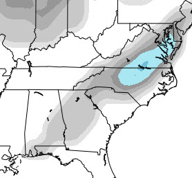
-
The December to Remember 7th-8th blue turd winter threat thread.
FallsLake replied to lilj4425's topic in Southeastern States
It really does matter where you live in the Triangle area. When I bought my house I actually drew a map and told the realtor where I would consider (basically Wake Forest SW to Apex - north/westard). I've been on the line many storms since I move to my location. The last one was the January storm and it looks like I could do it again with this one. Nerve racking... -
The December to Remember 7th-8th blue turd winter threat thread.
FallsLake replied to lilj4425's topic in Southeastern States
You guys saw the CMC snowfall maps. Here's the freezing rain (I guess it's pulling more cold air in):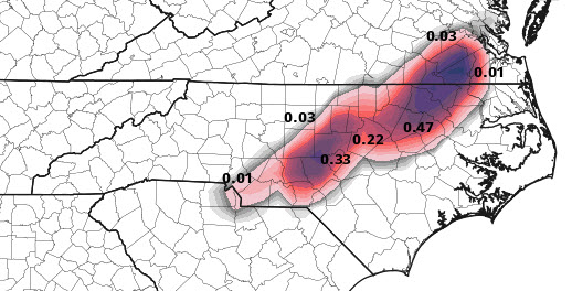
-
The December to Remember 7th-8th blue turd winter threat thread.
FallsLake replied to lilj4425's topic in Southeastern States
From RAH: Hazardous Weather Outlook National Weather Service Raleigh NC 500 AM EST Wed Dec 6 2017 NCZ007>010-021>026-038>041-071000- Person-Granville-Vance-Warren-Forsyth-Guilford-Alamance-Orange- Durham-Franklin-Davidson-Randolph-Chatham-Wake- 500 AM EST Wed Dec 6 2017 This Hazardous Weather Outlook is for central North Carolina. .DAY ONE...Today and Tonight. Hazardous weather is no expected at this time. .DAYS TWO THROUGH SEVEN...Thursday through Tuesday. light rain on Thursday through Friday night may mix with or change to some wet snow, especially across the northern Piedmont. Accumulations, if they occur, should be limited to a dusting or so, and generally confined to elevated and grassy locations. .SPOTTER INFORMATION STATEMENT... Spotter activation is not expected at this time. $$ -
The December to Remember 7th-8th blue turd winter threat thread.
FallsLake replied to lilj4425's topic in Southeastern States
By hour 69 it looks like a mix at RDU, but nothing significant to the west of the Triangle. Just a narrow strip of snow/rain from just east of Charlotte to RDU to Roanoke Rapids. **weaker storm -
The December to Remember 7th-8th blue turd winter threat thread.
FallsLake replied to lilj4425's topic in Southeastern States
At hour 63 it is warmer at RDU. What was a rain/snow look on the 12z at the same time, it's just rain on the 18z. -
The December to Remember 7th-8th blue turd winter threat thread.
FallsLake replied to lilj4425's topic in Southeastern States
Yep, a little warmer for 850s and surface at 57. -
The December to Remember 7th-8th blue turd winter threat thread.
FallsLake replied to lilj4425's topic in Southeastern States
Here's the JMA: -
The December to Remember 7th-8th blue turd winter threat thread.
FallsLake replied to lilj4425's topic in Southeastern States
Yep, it was the NAM. -
The December to Remember 7th-8th blue turd winter threat thread.
FallsLake replied to lilj4425's topic in Southeastern States
As you said before, this is a tough forecast. We could easily just get a lot of cold rain, or somebody could cash out with heavy rates (..like SC November snow). really not sure what to think at this point. -
The December to Remember 7th-8th blue turd winter threat thread.
FallsLake replied to lilj4425's topic in Southeastern States
Here's the types at hour 96: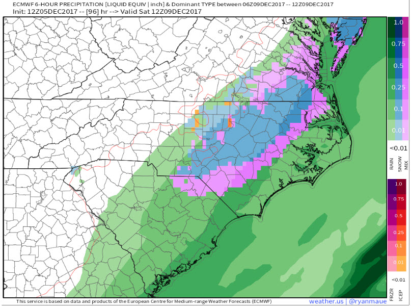
-
The December to Remember 7th-8th blue turd winter threat thread.
FallsLake replied to lilj4425's topic in Southeastern States
I think it looks good for RDU. Mostly snow for the entire event. -
The December to Remember 7th-8th blue turd winter threat thread.
FallsLake replied to lilj4425's topic in Southeastern States
I think it matters on how much initial cold air we can get in place before the storm. Right now it's not looking like much, but dew points will be in the teens right across the boarder into Virginia. If we can get some type of push of that air farther south this could become a good storm. -
The December to Remember 7th-8th blue turd winter threat thread.
FallsLake replied to lilj4425's topic in Southeastern States
Just the messenger.... -
The December to Remember 7th-8th blue turd winter threat thread.
FallsLake replied to lilj4425's topic in Southeastern States
And CR's freezing rain: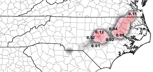
-
The December to Remember 7th-8th blue turd winter threat thread.
FallsLake replied to lilj4425's topic in Southeastern States
Your right. Here's the 12z: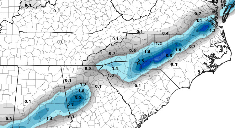
-
The December to Remember 7th-8th blue turd winter threat thread.
FallsLake replied to lilj4425's topic in Southeastern States
Here's a better map from Pivotal Weather: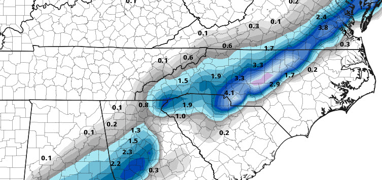
-
The December to Remember 7th-8th blue turd winter threat thread.
FallsLake replied to lilj4425's topic in Southeastern States
CMC is definitely better for MBY. It has colder surface temps, with even some ice showing up over CRs location.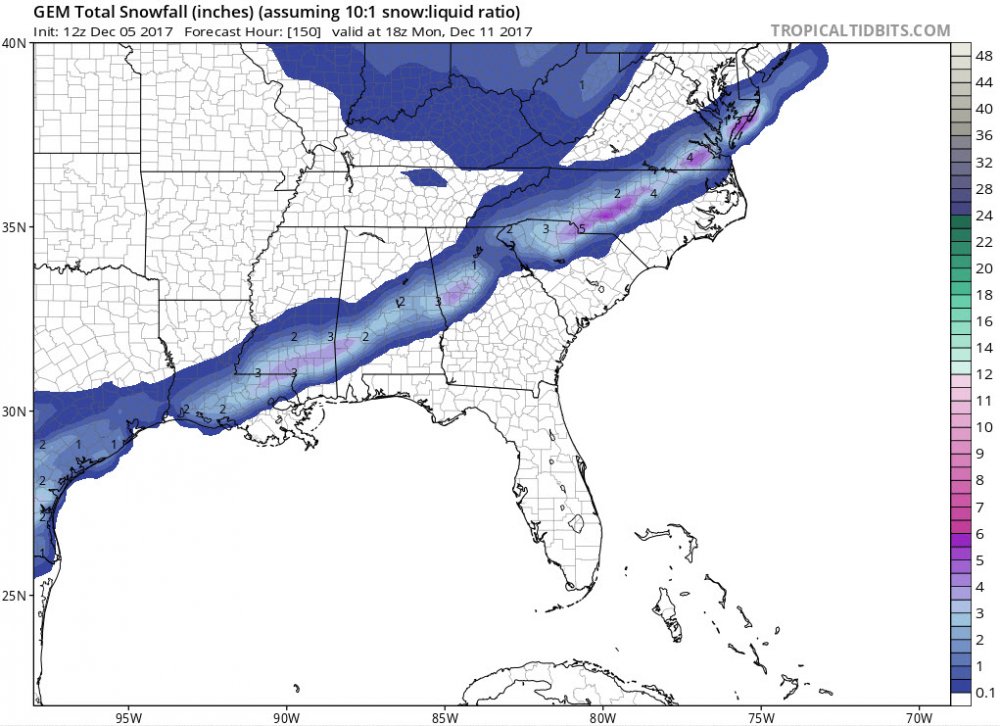
-
The December to Remember 7th-8th blue turd winter threat thread.
FallsLake replied to lilj4425's topic in Southeastern States
GFS at hour 78 is warmer. Just a little snow showing north of Greensboro into Virginia. -
The December to Remember 7th-8th blue turd winter threat thread.
FallsLake replied to lilj4425's topic in Southeastern States
Even with the NAM look, it would be a slush fest. Still I would consider this a win: total accumulation for hour 84: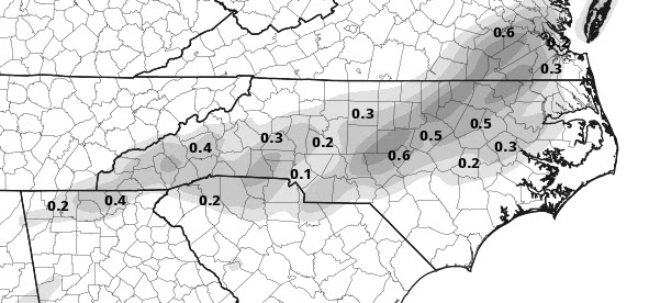
-
The December to Remember 7th-8th blue turd winter threat thread.
FallsLake replied to lilj4425's topic in Southeastern States
I think it would flip back to snow with the heaver rates. Dew points continue to show a colder look (...storm creating it's own cold):

