FallsLake
-
Posts
6,318 -
Joined
-
Last visited
Content Type
Profiles
Blogs
Forums
American Weather
Media Demo
Store
Gallery
Everything posted by FallsLake
-
If I could get another foot, I would tip my hat to your two feet.
-
^^Yep, verbatim (for RDU) it would be snow to rain then back to heavy snow. That would be a crazy storm..
-
It seems that has been the rule for the last three years(..at least). I keep wondering when we get another big eastern NC storm.
-
Single digits (on GFS) do get into western NC briefly. This is going to be a colder surface then last time.
-
You would think this would trend colder, at least on the surface. I keep on harping on the initial cold, but with dew points falling into the teens before this system arrives the CAD that does set up will have a better chance of verifying colder and farther south.
-
Definitely looking promising for some sort of wintery event. Thinking/hoping that CAD is a little stronger and more folks can get in the game. Big difference from the last event is this is popping up much closer to go time.
-
Looks like the 12z ICON is on board for a winter storm. At hr 156 has the snow line from SW NC to Raleigh then Rocky Mount. It only shows rain/frozen so I'm sure there is some ice below that line. Edit: Has the surface freezing line from Greenville SC to south of Charlotte, to south/east of Raleigh.
-
Hopefully today we see more model agreement on this next weekends potential. One thing I really like is we get cold air in place before the precip comes in. Also on the FV3-GFS it lost the lakes low (from 0z) and showed more of a CAD signature. If we get a good CAD setup expect more transition precip types to start showing up in later runs.
-
I still think the actual pattern change is going to be late this month into February. If we get this storm (as depicted above), it will be another perfectly timed event. Once we get a "real" pattern shift to a predominant cold pattern for the eastern US, that's when folks down east (including you) will have better chances.
-
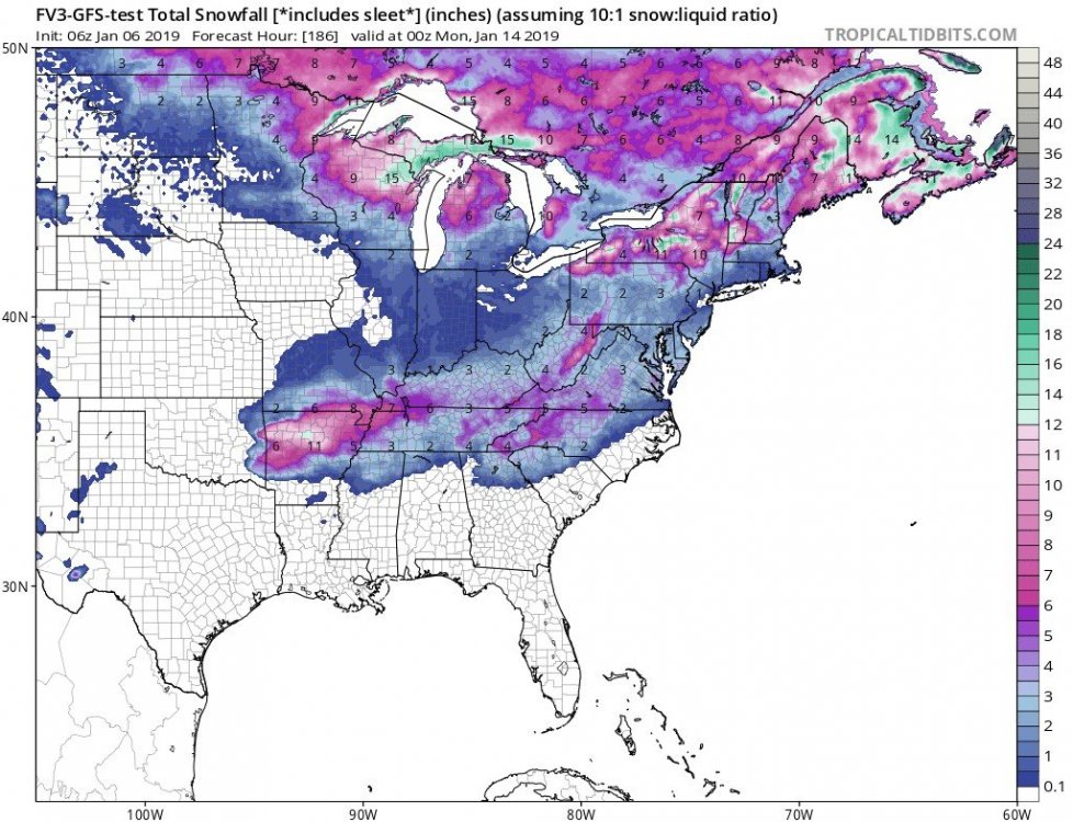
FV3-GFS continues to show a NE GA, Up State SC, central/western NC, and northward snow threat for next weekend. From RAH: The models are then in good agreement that the aforementioned mid- upr low/trough will lift newd and away from the nern US through the end of the week, with a reloading of the longwave trough from cntl Canada to the middle Atlantic states through the weekend. At the same time, a srn stream one is forecast to migrate across the srn US. Though uncertainty with respect to the timing, amplitude, and possible phasing of those features is high, the overall pattern will be one supportive of cyclogenesis from the GOM to the middle Atlantic coast, with sufficient cold air in place to present precipitation type concerns across cntl and especially wrn NC by Sat- Sat night.
-
Next week we may see lows in the mid 30s. That could give some folks a light frost.....
-
If things go like planned, this year will be a reversal of last; whereas we have a back load winter. Remember last February heat wave.
-
That's some cold air!! Has -40F temps entering the northern plains.
-
Happy New Years everybody! Lets hope we can score two or three good winter storms for most on the board.
-
Don't give up yet. As long as we flip to a favorable pattern by the end of January, we have a (good) chance. There were a few folks that predicted a back-loaded winter. Lets see if they end up being correct. **Wouldn't it be terrible if we didn't flip to a cold pattern and ended up with a repeat of last February.
-
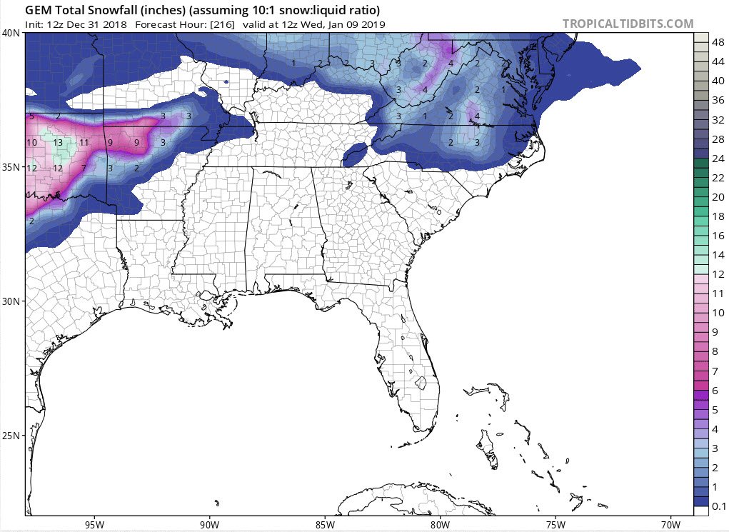
Well the 12z GFS went (more) north with the 8-9 system, but the Canadian came through to give us some fantasy snow:
-
It's possible. The models have been terrible lately. Not sure if we should still put equal weight towards the GFS, and put more towards the FV3-GFS.
-
If the 6z Fv3-GFS is correct we may actually see some below freezing temps by mid-month.
-
Usually with a negative NAO both western Europe and eastern NA can get cold and stormy. But, I've seen many times where Europe is cold and we never benefit.
-
All we can do at this point is hope the change starts occurring soon. Then we could feel the affects by mid month. The indices do look a little better today: PNA - Moderately positive moves towards neutral in the short range then back to moderately positive (good) NAO - Goes strongly negative in the short range, but goes neutral in the LR (with a large spread of positive & negative runs) AO - Looks to now go negative, with many runs strongly negative. This is a big change from yesterday (good) https://www.cpc.ncep.noaa.gov/products/precip/CWlink/daily_ao_index/teleconnections.shtml From everything I've read (for where we're at right now), we need the AO to go negative to get NA cold and into a pattern that favors an eastern trough / western ridge.
-
If the Fv3 GFS is correct most of us, outside the mountains, wont see freezing temps until ~mid January. Of course the Canadian, with its cold bias, says just wait until late next week.
-
Indices look ok to good today: PNA - Goes strongly positive in the medium range and stays positive in the LR (good/great) AO - Goes neutral and then averages neutral in the LR (but has some wide spread of positive and negative runs (not sure) NAO - Stays neutral in the medium range but then averages negative in the LR (maybe good) https://www.cpc.ncep.noaa.gov/products/precip/CWlink/daily_ao_index/teleconnections.shtml
-
The FV3 GFS is showing some potential at and after News Years. The LR models keep flipping around (more than normal) during that period, which could mean they're having issues seeing the (possible) pattern change.
-
If all that cold verifies for January (meaning some good blocking), there'll be some suppressed storm tracks.
-
It seems that when the p-type was snow and it was below freezing (making close to 10:1) it was actually very close. Some of those huge outputs (over 2" in the piedmont) was more tied to the higher QPF that was originally being forecasted.