Torchageddon
-
Posts
1,599 -
Joined
-
Last visited
Content Type
Profiles
Blogs
Forums
American Weather
Media Demo
Store
Gallery
Everything posted by Torchageddon
-
Loop is amazing.
-
Currently 16C/61F here, mainly overcast. Disgusting and this **** has happened multiple times this June. Got another 17 mm of rain overnight. Not June so far but the last 31 days I've received a staggering 131 mm of rain (5.16 inches), half of that in the last 9 days.
-

Spring/Summer 2022 Complaint/Banter Hangout
Torchageddon replied to IWXwx's topic in Lakes/Ohio Valley
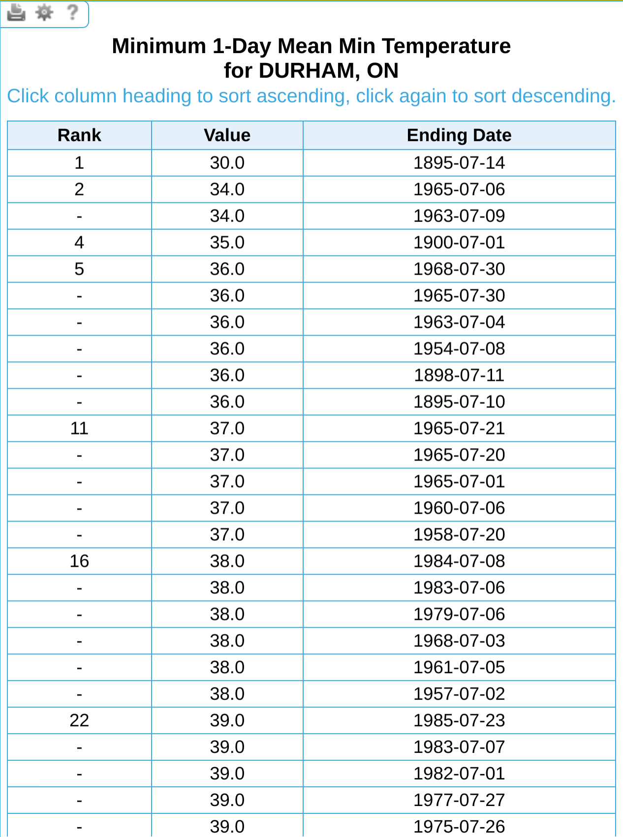
I was using that awesome site Hoosier gave me to look at extremes like mins and maxs in ON and I think I caught an error since there is no way Durham made it below 0 on July 14, even if it was 1895: I checked another station as close as possible (too bad many don't have 1895 records) to collaborate, and despite being further inland which should help diurnal cooldowns, it wasn't even close to 0 but more like 39F or 4C at Alton's station.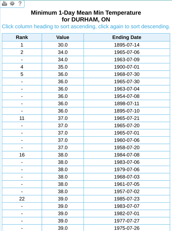
-
2022 Short/Medium Range Severe Weather Discussion
Torchageddon replied to Chicago Storm's topic in Lakes/Ohio Valley
Of course the first photogenic tornado from Ohio in many years is only 12 seconds long, makes sense. -
I'm curious what causes that sharply negative blob near Dallas amid surrounding positive anoms.
-
Spring/Summer 2022 Complaint/Banter Hangout
Torchageddon replied to IWXwx's topic in Lakes/Ohio Valley
@cyclone77 I was browsing the June 2012 thread and some image you posted somehow transformed into the Ukraine flag with the words "no war" printed: I guess the original file was edited from that image storage service but I didn't even know you could do that and retain the link without breakage. -
Hottest Weather So Far Lies Ahead for Phoenix
Torchageddon replied to donsutherland1's topic in Central/Western States
The good stuff. Those tables above with the stats looks vintage, nostalgia vibes. Didn't know 2020 had 53 days over 110F, would've been a good summer for me to reside there. -
How does one get the top 10 largest rainfall totals by day for cities like Chicago, Detroit, Buffalo, etc. using a current database? Checked https://www.weather.gov/wrh/Climate?wfo=dtx which doesn't have anything of the sort.
-
Spring/Summer 2022 Complaint/Banter Hangout
Torchageddon replied to IWXwx's topic in Lakes/Ohio Valley
Thanks I'll check it out. The Adirondacks Derecho would've grazed me but I wouldn't be old enough to remember it. -
Not that I believe the hourlies from TWN, but even along the shoreline winds were forecast to be elevated overnight with the temp reaching nearly as low as me. Gusts have calmed down.
-
I had an enormous diurnal temp swing that surpassed the previous largest, low of 5.5C and a high of 27C. Funny you mention the lack of clouds, it was almost 100% blue skies except a ghost or two of a wisp which is something I honestly can't recall before in a very dry day like this. Usually its either nothing at all or some fluffs. It was great out there. Overall it was a strange day since it got very breezy as the afternoon wore on and now its just plain windy as fall is, I'm getting gusts of 40 mph by estimate. Not many were outside by early evening. Going back down to 5C overnight with winds high?
-
Spring/Summer 2022 Complaint/Banter Hangout
Torchageddon replied to IWXwx's topic in Lakes/Ohio Valley
The wiki article on the Ontario Derecho had something I disagreed with and has since been removed. The cited source doesn't have anything about this within: "In Southwestern Ontario, a derecho can be expected about once every two years (once a year for Windsor-Essex), usually developing in the U.S. [[Midwest]]. The [[Kitchener-Waterloo]] and [[greater Toronto]] region experience derechos about once in every four years. Derechos in Ottawa, Montreal, and Quebec City are considerably rarer, but are not unheard of." It was removed a few days ago since the link below never had anything about Canada in it. I wasn't even sure if there was ever a documented derecho in SON, writing that K-W and Toronto get one every 4 years is ludicrous . For Ottawa, Montreal and QC - I'd have to disagree and say they are unheard of . https://web.archive.org/web/20141222110142/http://www.erh.noaa.gov/rah/newsletter/RAHNewsletter_Mar13.pdf If the author comes across this I'd like to hear their side of the story, and if there is evidence of a derecho hitting SON before May 2022. -
Spring/Summer 2022 Complaint/Banter Hangout
Torchageddon replied to IWXwx's topic in Lakes/Ohio Valley
In the early 2000s you couldn't pull up SSTs? That would be benumbling. That gives rise to this question, what was the earliest one could access satellite images online? I've seen floater images of TCs from 2002 but no earlier. -
Looked like a crap day but was waiting for the supposed clearing, found that blue skies rapidly came and an insane increase in my temps that even exceeded those isolated warm days during mid-morning recently. Just in 40 mins I went from 14.8C to 19.5C!! My station showed a 1.7ºC jump from 3:05 pm to 3:10 pm - largest I've ever seen. If I'd known that was coming I would've stood outside and pretended I was in Rapid City. I also had an extreme temp overnight yesterday where I was at 23C at 3:20 am (low of 21C), get those 4 times each summer, and this morning's low was 6C which I didn't appreciate. Had to dress like it was early-Spring.
-
The heat ended the lamest way possible, no storms! I had some short-lived showers. In the distance there were some rumbles. A May like we had and all those chances with not a single t-storm: phenomenal.
-
I can handle it if its just off of winter but without sun and higher winds, I'm not a fan anymore of high 60s for temps.
-
I was just going to post that I had just that one afternoon a few weeks ago with many rumbles of thunder but no real t-storm for May here, I'm at 3-4 storms for 2022 with 1 occurring in both March and April. I'm curious if I can make it through this heat without a storm, crazy if I do. I had one flash and a few rumbles during the historic Ontario derecho 10 days ago. Awesome day so far, I'm sitting at 32C/89F with the highest DP so far making it feel like 36C. Its very unstable with many roll clouds. I'm beaming after the terrible spring of clouds and non-heat like low 20s that still feels too cold. I must live in a climate like Phoenix has.
-
From last check there have been 0 tornado reports both on the 28th and 29th. Considering its the end of May, and both days were ENH that is bewildering.
-
Spring/Summer 2022 Complaint/Banter Hangout
Torchageddon replied to IWXwx's topic in Lakes/Ohio Valley
I don't think I've laughed this hard on here in years, maybe ever -
Spring/Summer 2022 Complaint/Banter Hangout
Torchageddon replied to IWXwx's topic in Lakes/Ohio Valley
I put a question in AndiSearch I never thought I'd get a clear answer to but was surprised and then dumbfounded:
-
What will facilitate the dissipating of those storms in the morning?
-
I haven't heard this phrase, found out peal is a synonym of ring/clang. TWN at the last min forecast storms both thurs and fri and I never had anything. I'm not complaining. Its cloudy today, mix of sun and clouds isn't present!
-
2022 Short/Medium Range Severe Weather Discussion
Torchageddon replied to Chicago Storm's topic in Lakes/Ohio Valley
I've never seen one that long either, impressive. A large MCS is hauling across SON this Sat: This MCS is meaty, had a few flashes of lightning ironically when nothing was forecast this afternoon, but yet all those chances of strong storms yesterday into early this morning just nothing lol. -
Storms forecast 3 separate times today, morning ones weren't even close, nothing at 7pm-10pm, then some close by storms just after 10 that somehow fizzled out fast despite thermos being decent. The CAMs which can't be trusted showed storms at 1am-7am at some point but backing off that now just showing light showers haha. I'm not complaining! ^ That went to this in 40 mins:
-
At one point my 7 day showed a min of 23C/73F on Fri which if that happened would be one of the most insane temp anomalies I've ever had. Of course its not going to verify but just to show how cartoonish my forecasts are now: My min from one day to the next has also never been that different AFAIK.