
Torchageddon
-
Posts
1,609 -
Joined
-
Last visited
Content Type
Profiles
Blogs
Forums
American Weather
Media Demo
Store
Gallery
Everything posted by Torchageddon
-
I've had to endure weeks of no sunlight until this morning when it was mostly clear til 2. Then more dense clouds.
-
I found a youtube channel that is putting out quality content on past severe events and tornadoes with synoptic maps and layman explanations. I've seen 3 videos so far and I'm really impressed, its growing very fast as it should. I've been looking for a channel like that for a decade with all missing the mark. I could probably watch every video put out which is exceptionally rare for even my favorite channels. Those classic events we know much on I'm learning stuff. Well-rounded and entertaining too. https://www.youtube.com/@weatherboxstudios/about
-
I haven't had a synoptic snowstorm in Dec here since 2008, I'm predicting the streak continues again this go around. Can't get over how absurd that is for someone in Canada of all places.
-

Winter 2022/23 Lake Effect Snow Thread
Torchageddon replied to Chicago Storm's topic in Lakes/Ohio Valley
Three firehoses, prev two with a connection. I'm getting my first rippage of the season.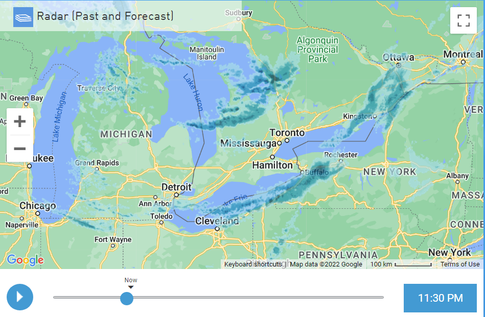
-
Winter 2022/23 Lake Effect Snow Thread
Torchageddon replied to Chicago Storm's topic in Lakes/Ohio Valley
Thicc band just barely missing me to the north by miles. Must be amazing in the heart of that beast and I won't be seeing it, cool.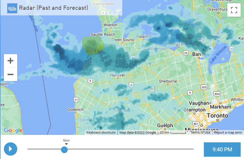
-
Winter 2022/23 Lake Effect Snow Thread
Torchageddon replied to Chicago Storm's topic in Lakes/Ohio Valley
I don't consider it a good area anymore, its been many years since a decent les event that was sustained. I find the best ones are when there is a firehose coming from the NNW not W. Something with the topology messes with the latter. I have roughly 5 inches but some of it actually melted today due to the sun. A nice band is just to my north currently but I haven't seen anything of note. Some amazing returns south of Port Elgin, inland les for Stratford this evening. -
Winter 2022/23 Lake Effect Snow Thread
Torchageddon replied to Chicago Storm's topic in Lakes/Ohio Valley
Hanover -
Winter 2022/23 Lake Effect Snow Thread
Torchageddon replied to Chicago Storm's topic in Lakes/Ohio Valley
Classic. I'm in between the bands in SON so I got mostly sunny skies this morning while up north they are being rocked.
-
Unfortunately also in my case this, starting Sat the wx turned to absolute s*** and what do I get out of this? Just two inches (of snow) as of right now when patterns like this in the snow belt should yield colossal amounts like 1-2 feet. Same story every year when we get a cold snap in Nov.
-
What is your favorite weather day of all-time?
Torchageddon replied to Hoosier's topic in Lakes/Ohio Valley
I haven't read any replies yet but a few thoughts: a topic that is thought-provoking was long overdue on this sub. And having one for each season would also be good for those biased to one season. I don't have any that are obvious which makes it a fun one, although May 12 2000 first jumps out due to the awesome spring air and humidity I felt followed by the worst thunderstorm that is still #1. There are various dates where it was dynamic or pleasant IMBY but also something wild was taking place within the continent. It would take time to research that as its hard to come up with dates. Some include Mar 11 2012, Apr 1 2010, Oct 8 2018. Winter: Jan 6, 2014 (Lake effect blizzard and the early part of the day also had intense bands and a cool vibe) Spring: Mar 11, 2012 (If I got the date right, severe thunderstorm overnight with 20C temps and party cloudy during daytime. Recall puffy clouds and a summer mood when normally I have a 2 foot snowpack, instead nothing on the ground except small piles hidden) Summer: Jul 21, 2012 (Hottest day I've lived through IMBY. I was high on heat from the beginning to end; also tracking some Epac hurricane) Autumn: Oct 8, 2018 (Was able to swim in the lake on Canadian Thanksgiving, very high humidex and incredible clouds! Scents in the air was insanely good) Aside from the winter one these dates admittedly are heat based, events like wind storms and oddities I would have to spend time on. -
I'm already up to 21C / 70F (again!) which is 3C over my forecast high. This coincides with the other 20C+ reading two years ago today which is in itself a once in decade or perhaps more event. Low was 10C. Smells like spring outside, hopefully on the way.
-
I wish I had archived that Unisys track database fully as only the front page had been crawled to Wayback and 1 other before they turfed it along with some maps. I noticed that Yankee and Kate hurricanes are in that Unisys track map format which was always my favorite. I did locate them on different random sites but was there another source of more? Other formats are so unappealing I'd rather just have the software myself.
-
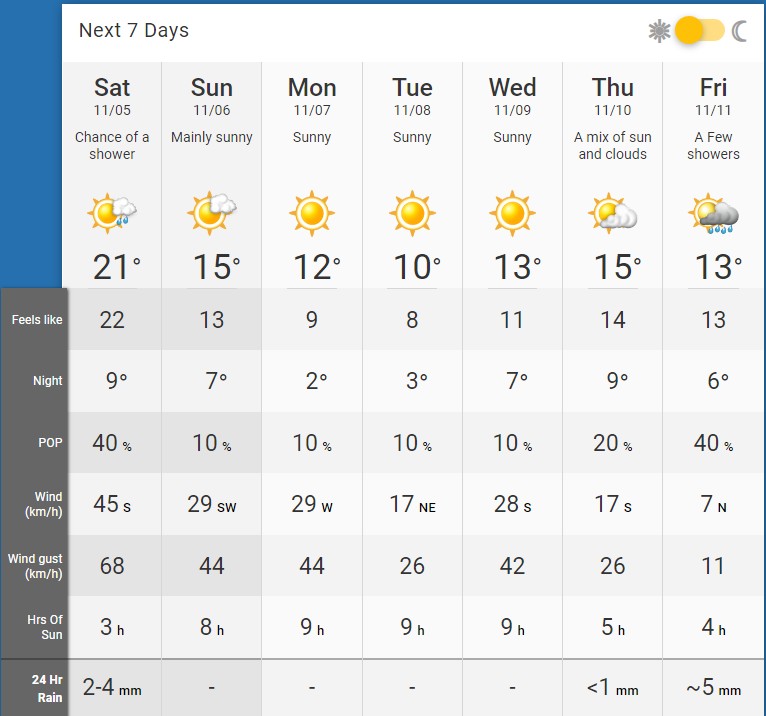
What is this effluence at the end of my 7-day? Gah!
-
Its 8pm and I'm still at 21.4C! The rain that was suppose to start at 3pm never came, showing some minor showers at 9-10pm still (old hourly shows sooner and longer below). It actually increased in temp after dark here, wtf. This is just getting stupid. Can't forget 3 years ago tomorrow I had wind chills of -20C! Edit: Went higher to 21.9C at 9pm then by 9:40 started to fall rather quickly 1C per 10 mins as the rain and front passes. Sustained winds also increased.
-
At 6pm my station still shows 21.3C / 70F with pressure 999 mb. Had great sunny skies for a few hours during the first half of afternoon with 22C peak. Low went to 15C - if I had good records that likely was one of the warmest Nov lows in modern times. Dataset here from 1980-2010 shows only 10 days where my minimum was above 0C. Nearly 7pm and I'm still at 21.3C humidex of 23. I enjoyed the windy warmth. When the wind warnings pop up I take a stroll. Can't believe what took place 2 years ago just repeated itself.
-
I made it to 21C / 70F, too breezy to fully enjoy and cloudy. Low tomorrow of 16C after being decreased to 9C just yesterday - what on earth is that algorithm up to now lol.
-
Still have them here, I just captured a massive one the other day. The frosts also do nothing for my allergies. Sat now up to 21C / 70F with high winds, that would be near 2020 levels of goodness. As for my updated 7 Day, can I have this every November?
-
Very happy with this opening of Nov, yesterday though was a let down for the first half. I could get to 20C if everything lines up either today or sometime this week . Most insane is the forecast low on Sat of 14C / 57F (Nov 5)!!! Made it to 19C on my station, should also add 23 years ago today I had nearly two feet of snow on the ground but this go around I'm walking around in shorts and soaking up the full sun, green fields remain.
-
My hourly forecast has been hilariously bad this early afternoon, I'm cloudy with sunny breaks at best but here since 11am it was showing mostly sunny and then by 1pm (not shown) no clouds while I was overcast. Satellite clearly shows otherwise:
-
I remember it fondly, one of the most extreme events here in years (SON it was more anomalous). Most memorable was how it was balmy at 5:30 Nov 10 after the sun set; it felt like a warm summers' evening, humidex was an insane 23C!!! That in isolation might be a once in a 100 year occurrence. It got very cloudy just before dusk which kept the record shattering heat from escaping. Normally during that part of fall after the sun sets the temp drops by 1ºC per 15 minutes. Getting back to this weekend's great wx, I got to 23C for the 2nd day in a row with mostly sunny skies. My 7 day shows a ton of sun for this time of year.
-
IMBY. Doesn't get much worse than this!
-
Getting my typical rain-showers with grapple that Oct brings here. Only 20 mins of sun at 2pm. When another wave of showers came by just now at 5pm I was down to 740 lux. Yesterday for the first time in months I was put under an advisory (for wind), it was just a breeze lol.
-
I had a pre-payment, last week's and the one before that 6 day dank fest. Today and tomorrow will be good, 20C and sunny but today was 6C less.
-
A rare bust on the good side, thought I'd wake up to rain and darkness with TWN showing 4-7C temps, windchill near 0 and rain most of the day. Here its blue skies each direction! We got very lucky that the lake effect rainbands aren't quite reaching but I can see them just a few miles away . TWN current condition page is full of it, showing rain instead of clear which is amazing for 2022:
-
I noticed during Ian's LF that here it was dark and gloomy which isn't something I remember for other landfalling canes especially during this part of hurricane season. Not talking late Oct or Nov hurricanes though where I'm mostly under overcast or dreary wx.


