
Torchageddon
-
Posts
1,599 -
Joined
-
Last visited
Content Type
Profiles
Blogs
Forums
American Weather
Media Demo
Store
Gallery
Everything posted by Torchageddon
-
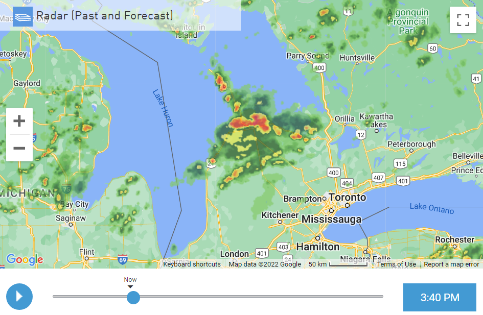
Love the contrasting colours and the mid-day bightness, love that pic. Low was a higher than avg 19C/67F overnight. I'm finally getting a long downpour making up for the misses last week and I'm at 20mm / 0.79in. It was a cluster of heavy showers (minimal thunder) and now this is an unique radar look:
-
I'm only getting some brief, light showers during these pulse storms nearby this week, my station doesn't even record any amount of rain but I suspect its more than 0.1 mm. Heard some thunder on Weds and today. I missed the heavy stuff very close by.
-
Getting pretty messy out there, got my first t-storm since April, ah snap. Torrential rains multiple times over the last 45 mins that I haven't seen for a long while. Got 15 mm/0.6 inches in mere minutes. Only had a few bright flashes but randomly at several points I'd see clusters of frequent lightning then nothing for minutes.
-
At 88F/31C with mostly cloudy skies, not a combo that happens much. Very breezy.
-

Summer 2022 Medium/Long Range Discussion
Torchageddon replied to Chicago Storm's topic in Lakes/Ohio Valley
Usually terrible summers like that one have a bit of a balancing out with a warmer Sept or Fall, also some nice Springs like in the 70s. June-Aug climo is good here but you have decent Spring/Fall where here we don't. 3 good months out of 12 still means a sucky climate here near the Lakes in SON. -
Summer 2022 Medium/Long Range Discussion
Torchageddon replied to Chicago Storm's topic in Lakes/Ohio Valley
So glad I was too young to remember the stench that was the summer of '92 -
Spring/Summer 2022 Complaint/Banter Hangout
Torchageddon replied to IWXwx's topic in Lakes/Ohio Valley
Save worthy run, Hr 372 is particularly wicked *chef's kiss* -
I managed to get through the entire month of June without a single t-storm or clap of thunder. Yesterday and today's temp trend will set the perfect indoor conditions; the temp started falling faster than usual at dusk but then leveled off at a nice 22C all of overnight, 3rd warmest overnight period. It got to its lowest once the pesky rain started at 8:30 am. No storms forecast for the rest of the day, I'm not complaining.
-
There remains a signal within the various model output that the environment may become marginally conducive to organized convection, including supercells, in a narrow corridor north of the international border (across parts of southeastern Ontario into the St. Lawrence Valley) by late Friday afternoon. However, given the rather weak forecast boundary-layer instability across this region, it seems probable that this activity will tend to weak as it spreads into a less unstable air mass near and southeast of the international border Friday evening. July 1 in S/E ON. I got 6.6 mm of rain this morning. Nice evening now.
-
A few cells near London and Stratford ON that formed like the HRRR showed but nothing here! This isn't the June I'd experience as a kid, no endless dry cold fronts lol. High chance that I go the whole month without a single t-storm as the next chance is July 1...wow. I had a storm in March. Current temp at 61F feeling like 59F, yes after having some of the hottest days in recent memory I'm getting a friggin' windchill! One of the most rollercoaster Junes.
-
I was suppose to get light showers this morning and then chance of storms later on, I woke up to sunny breaks and turns out, no rain at all! Temp over-performing too because sunny breaks in the overcast. It would be hilarious if I can get through another heat event without any storms but today I'm getting July 8, 2007 vibes with this overcast and muggy Sun afternoon. A F1 tornado that was photogenic touched down 20 mins away from me and it was also a unicorn Supercell that went due south from the peninsula that brought me the worst hail storm I've ever seen here, including the absurd report of tennis ball sized hail in Harriston. I'm not snoozing on today.
-
I'm at 92F so far, I got to 90 before noon. Can this be one of the hottest days I've had?
-
This is the 3rd day in a row with blues skies, pretty much the best wx during the year here. Temps are just perfect keeping things comfy at 88F for a high with modest lows/low DP so things don't become too oppressive. TWN forecasting another 34C/93F high with some humidity tomorrow which is kind of wild. Can we turn this into another infamous week like June 2020 featured?
-
I'm very surprised Toronto got to 95 yesterday, I only got to 83. The early evening got cool and dry.
-
Perfect summer solstice day, I'm at 30C with DP of 20C! Blues skies. If only every day of the year was like this.
-
The 2022 Summer Solstice-ish Scorcher(s)
Torchageddon replied to Hoosier's topic in Lakes/Ohio Valley
TWN is forecasting the hottest temp IMBY in years of 34C/93F with a humidex of 42/108! On Wednesday when they set my high to 31C I actually got to 35C; I'm hoping I get to the 100F mark somehow later tomorrow. After that amazing low on Sat morning of 5C/41F I'm looking forward to this. -
I got an incredible low temp of 24C/75F overnight which I reckon is a once in 3 year occurrence here. It even bumped back up to 25 for a hour or so after 4am. Lackluster showers were moving close by or just missing me resulting in no rain, sweet.
-
Summer 2022 Medium/Long Range Discussion
Torchageddon replied to Chicago Storm's topic in Lakes/Ohio Valley
Great stuff!! -
It was a lovely day where I may have had one of the hottest temperatures in several years, 35C . It stayed above 34C for 3 hours. My station reported a HI of 45C or 113. Torrid, oppressive, sauna like. Aside from the morning I also didn't have those stupid clouds ruining the day, I could see the wind shift clearly on satellite. TWN isn't in agreement with my temp but shows Windsor ON reaching a humidex of 46. TWN also showed rain starting at 6:30 pm when there was nothing for 100s of miles, then changed it to 7:30 pm, same . Now its gone as even the clouds all over my region are fading, precip start/stop feature - useful tool!
-
I'm getting extreme conditions currently, 33C/26C/41C / 92F/79F/106
-
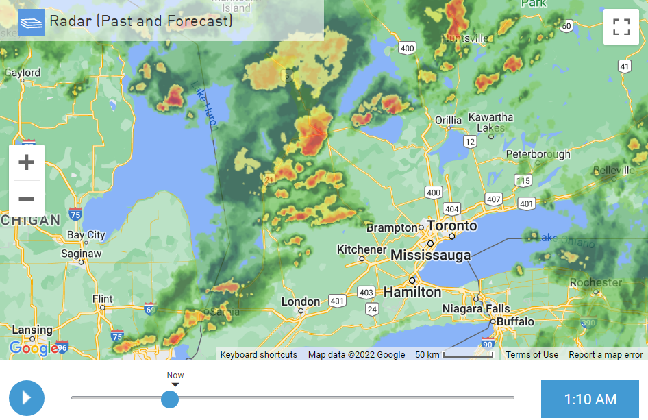
Woke up to overcast skies and found this. The whole of the bruce peninsula was cloaked in storms which is neat. Area under a STW: 6:08 AM EDT Wednesday 15 June 2022Severe thunderstorm watch in effect for: Bruce Peninsula - Sauble Beach - Tobermory Owen Sound - Blue Mountains - Northern Grey County Saugeen Shores - Kincardine - Southern Bruce County Conditions are favourable for the development of severe thunderstorms that may be capable of producing strong wind gusts, large hail and heavy rain. Hazards: Nickel sized hail. Locally heavy downpours. Timing: This morning. Discussion: A line of strong thunderstorms has developed near Bruce Peninsula and is expected to move south this morning. Large hail and locally heavy downpours are the main threats. Overnight low was 18C, nothing special. Mostly 20C+.
-
Spring/Summer 2022 Complaint/Banter Hangout
Torchageddon replied to IWXwx's topic in Lakes/Ohio Valley
Ohio is further south but those minimums don't seem so crazy to me, what makes me think the 30F is an error is that the next record low for July is 34F tied and were both in the 1960s. If 30F was reached on July 14 1895 then something extraordinary in the records would be present like the airmass or something that could bottom out temps. The frosts were light in OH so above 32F we can surmise. -
I was just going to respond the same, yay more acronyms! Never seen NBM either - Numerical Based Models? I'm up to 29C/84F with a peak a bit higher briefly. Looked stuck around noon so I'm pleased it broke past 27C.
-
Jume is my new fav month. I like the sound of that. After the clouds rolled back in mid-afternoon yesterday like they seem to around here, its nice to see my forecast bust hard for this morning. Blue skies instead of light rain and more of the grey effluence. I thought this was possible due to the encouraging trends on radar late last night. May that bump my highs up, I'm sick of feeling cold in Jume.
-
The Van Wert storm is a unit!


