
Torchageddon
-
Posts
1,599 -
Joined
-
Last visited
Content Type
Profiles
Blogs
Forums
American Weather
Media Demo
Store
Gallery
Everything posted by Torchageddon
-
I like today's spring wx, isolated showers popping up with some nice clouds. Not bad in the temps department either.
-
High of 16C / 61F for today which is 3C higher than expected, close to the 4 over I was pining for.
-
I over-performed yesterday by 4C which is a welcome surprise, hoping for the same again today after a horrific weekend of dank. All my snow is gone.
-

Texas/Oklahoma Discussion & Obs Thread 2022
Torchageddon replied to It's Always Sunny's topic in Central/Western States
When I checked the Day 4-8 SWO it looked like the same spots outlined for the third time in a row! -
March 2022 General Discussion
Torchageddon replied to SchaumburgStormer's topic in Lakes/Ohio Valley
I woke up to a nice surprise of sunny skies and a temp far above what was predicted for 8am, 12C! Finally a forecast that busted far too low. Strangely the stations are all showing overcast curr obs. At one point I was expected to have 86 km/h gusts - so far there are a few strong breezes here and there but nothing much sustained -
Just saw that, must be one of the greatest lightning scenes I've ever seen Doesn't seem real!
-
March 2022 General Discussion
Torchageddon replied to SchaumburgStormer's topic in Lakes/Ohio Valley
You can see the swathes of LES bands on sat from the last few days. -
March 2022 General Discussion
Torchageddon replied to SchaumburgStormer's topic in Lakes/Ohio Valley
Just heard some thunder with the temp being 1.5C or 35F, that might be a new personal record as the previous lowest with lightning/thunder was 2.5C or so. Never had it below freezing around here. I've been getting bursts of heavy rain starting late afternoon and I'm sitting at 17mm/0.67" so far today. Dundalk ON continues to have freezing rain at times heavy; I'd hate to be a resident there today. Another inch or so of that forecast. -
March 2022 General Discussion
Torchageddon replied to SchaumburgStormer's topic in Lakes/Ohio Valley
Overview. So far I'm hovering around 1C while the heavier rain is moving through. Dundalk according to the often unreliable TWN, is -1C with "heavy freezing rain" current obs . Last I saw that was likely 2013. -
March 2022 General Discussion
Torchageddon replied to SchaumburgStormer's topic in Lakes/Ohio Valley
What is this conveyor belt? -
From 8 mins ago, Taylor.
-
The Taylor tornado rapidly became a wedge, insane footage on KXAN!!
-
March 2022 General Discussion
Torchageddon replied to SchaumburgStormer's topic in Lakes/Ohio Valley
I wasn't aware that hard freezes happen every April, I just assumed above avg or record warm Aprils wouldn't. I'll also check Mar 2010 again because I don't remember it being above avg perception wise. Today was an even bigger bust than yesterday, I made it to 7C (briefly) and point was set to 13C, then 11C. Dumpster-tier day. -
March 2022 General Discussion
Torchageddon replied to SchaumburgStormer's topic in Lakes/Ohio Valley
Why not? It was the freeze in April that caused the damage. It brings an interesting point up whether its possible to have Morch and then a April/May that are also above normal or even avg in temps - I asked a met this and the answer was simply no. You can predict a monthly avg just based on the magnitude departure of a month before it? Yesterday did actually reach 18C but it was mostly filtered sunlight and then cloudy by evening. Waterloo ON got to 19C, Windsor and likely other towns in extreme SON got their first 20. Its very dark this morning. -
March 2022 General Discussion
Torchageddon replied to SchaumburgStormer's topic in Lakes/Ohio Valley
The key 10 days of the Great March Heatwave were some of the happiest days I've had. -
March 2022 General Discussion
Torchageddon replied to SchaumburgStormer's topic in Lakes/Ohio Valley
Today's forecast here busted horribly, 13C for a high with 5 hours sunlight - instead got to 9C with less than 2 hours of sun. Somehow after this my point for tomorrow was raised to 18C, mainly sunny (after showing rain and 14C) . I took a screengrab of that this time, can't wait. -
March 2022 General Discussion
Torchageddon replied to SchaumburgStormer's topic in Lakes/Ohio Valley
For once I'm getting a locked-in LES band that is bringing whiteouts for the entire afternoon thus far. Among the most intense winter wx so late I've seen. Its the exact opposite of a decade ago when I had a severe thunderstorm and 70F temps, today the temp is falling midday to 15F feeling like -4F and heaviest snows of the winter . -
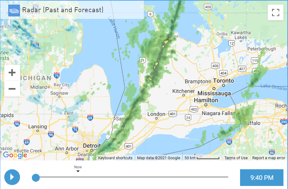
We had our 1 hour of winter fun for the season with the passage of 2 LES bands that brought whiteout conditions in Huron and Grey-Bruce counties (and eastwards towards Barrie). It wasn't quite the blizzard conditions I was hoping for compared to similar setups from other years, but seeing blue skies and the sun within minutes was once again a feature. This winter is still a 0 like the previous five. 30 mins of neat wx during a season is remarkably lame. The evolution of these bands is interesting on radar:
-
I was put under a blizzard warning as I'm near the lake, one of those diluted ones. Its pretty bad out right now so I'll have to get up early to see if it verifies. During the last few years the last 10 days of Feb seem to feature the worst of winter.
-
Temp in the last few hours has been rising fast, from 8am to 9:30 it went from 2C to 6C. I haven't seen rain since Nov.
-
I had my 17th t-storm of 2021 last night, had about 10 flashes of lightning with gusty winds when it was 4ºC. After the sharp squall line passed within minutes it went from rain to snow. Amazing to have 17 storms in any year.
-
Really great day today, clear blue skies with a high of 14C. Hard to get these this month. Still pales compared to last year's amazing heat event where I was over 20C for a few days - fond memories.
-
I'm up to 93mm or 3.66 inches of rain in the last 24 hours, likely the most I've ever documented imby within a 24h range. Forecast was showing 100mm today which is also a first, this is definitely the most substantial rain event I've experienced. I knew we were going to pay for those two days (which was last weekend) of cloudless warmth.
-
My overnight low was 20ºC which I have never seen this late except perhaps that hot spell in mid-late Sept 2017. I only had 20C+ minimums 3 times during this whole summer.
-
The 2nd Tuesday in a row of a tornado warning for Grey-Bruce/Huron county and this time I saw the rotation right at home! In the beginning I wasn't sure if I saw a funnel or just scud but I could briefly see the rotation just like I did in the Plains. It lined up with reports of rotating wall cloud north of Walkerton moving east. Then a new couplet must have formed to the south and OPP in Mount Forest reported a touchdown 30 minutes later around 7:30 pm. I had a lot more lightning and rain than last Tues. No hail for me. 4 waves of storms this evening and I'm up to an astounding 14 storms for the year This has been so far the most active September I've ever seen for storms and others concur. With all these tornado warnings this is getting insane .


