
Torchageddon
-
Posts
1,599 -
Joined
-
Last visited
Content Type
Profiles
Blogs
Forums
American Weather
Media Demo
Store
Gallery
Everything posted by Torchageddon
-
I'm impressed by how heavy the rains have been during the last 24 hours. I may reach 30 mm afterall. The returns near Miss and Hamilton are drench-worthy. The squirrels are back out playing and buds are appearing on some bushes. Spring I guess.
-
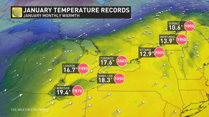
All-Time Jan records map, I didn't know Windsor's records go back to 1870s. That may mean there has never been a 20C+ reading in SON since the beginning of records for the month of Jan.
-
Tues Jan 3 jumped from 8C to 13C in one forecast cycle now with moderate-heavy rain. Sun-ish by next weekend.
-
Nice to see the sun out again this morning, I've been ahead of temps since last evening so hoping for a 8C reading later on.
-

Pre-Christmas (Dec 21-23rd) Winter Storm Part 2
Torchageddon replied to Chicago Storm's topic in Lakes/Ohio Valley
This morning winds are still up with more gusts albeit not that crazy with larger flake size, still no distinct bands. I was warming up slowly overnight. Aside from the longevity of the moderate-high winds, a distinct trait with this storm is how even with the high winds everything is plastered with snow like trees and power lines that somehow don't get carried away. Jan 6 2014 had this but there might be even more plastered than that one. Niagara Falls southern half is getting the death LES band that BUF has, rare. -
Pre-Christmas (Dec 21-23rd) Winter Storm Part 2
Torchageddon replied to Chicago Storm's topic in Lakes/Ohio Valley
I waited for this thing to start cranking and it did slowly ramp up throughout most of the day til 8 pm but overall this was a big bust and I'm not impressed lol. At no point did I witness any blizzard conditions as forecast for my town and my winds never made it high enough. This is NOTHING like Jan 6 2014, it barely stands out but I would consider it a solid winter storm; I was expecting the basement to be a major winter storm and I don't know if I can even call this that by Christmas Day. The main issues are the same as written above, flake size far too small due to strong winds and lack of moisture. My temp got down to -11.6C and then stabilized with a wind chill of -22C. I doubt I got 40cm (for Fri) as thought - probably 20cm with drifts. The LES mode was totally different from what I expected and never got in the mod returns like the shoreline did and there isn't any bands near me like Parry Sound and Buffalo has. I don't know why my winds were crap other than the orientation but still with the strength of this low it shouldn't have been this zzzz. By 10:30pm the flizzard started winding down when earlier I expected raging blizzard status and a double dip for Eve which my hourlies still show bizz for 8+ hours later on . Amazing that Hamilton got blizz but not me, that's a twist. There is some magic going on near Lake Erie and Ontario for sure in this storm. I did notice areas way south were much colder than me like London and Windsor ON got windchills of -28 to -32 whereas I'm getting -22. Same with air temps. -
Historic Christmas Lake Effect Blizzard
Torchageddon replied to BuffaloWeather's topic in Upstate New York/Pennsylvania
With the comparisons to the 1977 Blizzard, is it the length of time with 0 vis that is being used to benchmark? It was also a different type. Unfortunately not for me, its been lackluster and an epic bust locally for my region however its a solid winter storm. For my lake (Huron), its annihilating Parry Sound currently with a dream band. Wish I was in Buffalo rn. -
Upstate NY Banter and General Discussion..
Torchageddon replied to wolfie09's topic in Upstate New York/Pennsylvania
Coincidentally as I was reading the ongoing LES blizzard for Buffalo I watched this and 12:07 is pretty relevant! I didn't catch which storm he referenced at 10:40 for BUF. -
Pre-Christmas (Dec 21-23rd) Winter Storm Part 2
Torchageddon replied to Chicago Storm's topic in Lakes/Ohio Valley
Mainly the underwhelming part so far is the lack of strong gusts which I assumed would be fierce by 10am, few of them and not big but I did get a coupe shortly before noon and then suddenly a calm with sustained. Temp drop is ahead of schedule. My snowfall has been okay but with the recent calm also diminished. On radar I see something trying to get going north of Sarnia but only some lake enhancement just along the shore. -
Pre-Christmas (Dec 21-23rd) Winter Storm Part 2
Torchageddon replied to Chicago Storm's topic in Lakes/Ohio Valley
I woke up to some modest winds but just light/mod snow, temp was crashing by 9:00 am from -1 to -5C in 90 mins. Lowest pressure recorded was 982 mb. I expected winds to ramp up out fast around 10am and that never happened, in fact they might have even subsided!! I did some shopping in this so-called "blizzard" that has been rock solid consistent in guidance and my unreliable local forecast, outdoor conditions were okay! The winds will have to ramp up majorly from this even in my neck of the woods or this pre-LES phase will be a major/epic bust. Now my station is showing pressure is actually going up now, that wasn't suppose to happen til early tomorrow morning!!! I'll give this til 10pm tonight to impress otherwise I'd be a fool for not being stronger in the face of temptation but I couldn't handle it -
Pre-Christmas (Dec 21-23rd) Winter Storm Part 2
Torchageddon replied to Chicago Storm's topic in Lakes/Ohio Valley
While on the subject of pressure, I've fallen 28mb since midnight to now so sitting at 999 mb. The lowest since I've started tracking was 985 mb so I'm eager to experience what ~976 mb feels like (I feel different during low pressure events). The critical hour of change will be 9-10 am tomorrow. -
Agree, more like 2012 I think here. When I meet new people something I like to ask is if they perceive storms as being worse in the far past than they are now and only 1 out of a dozen said no. The one who stated nah thought heavier rains were occurring in present t-storms but I haven't noticed. Everyone else knows storms are mostly bark no bite in current times.
-
Pre-Christmas (Dec 21-23rd) Winter Storm Part 2
Torchageddon replied to Chicago Storm's topic in Lakes/Ohio Valley
From TWN. That 50-75 contour is incredible and I'm smack in the middle of it. Sorry Toronto however I don't buy one bit into maps like this and it was a snapshot from this morning. -
Its about time I get some interesting wx, amazed at how stupidly boring most of the recent years have been so maybe this blizz will make up for it, unlikely but I expect an equalizer. My t-storm season started off better than other years with more in the early warm season but then became a joke by June. Not a single one was memorable, even regular t-storms were weak caliber, forget about any possible severe here. Last exciting event was tor warned storms in Sept 2021. I wrote in one of these banter threads we haven't gotten a synoptic snow storm for Dec IMBY since 2008 so I went with the trend for another Dec shutout - jinx.
-
Pre-Christmas (Dec 21-23rd) Winter Storm Part 2
Torchageddon replied to Chicago Storm's topic in Lakes/Ohio Valley
My 7 Day in Hanover, in 20 years of following TWN this is among the most insane . I've never seen the header "blizzard" locally in one of these, 89 km/h gusts is the highest PMX has spit out locally. 65-85 cm in 3 days (26-33 inches)!! Per usual I won't believe it til its happening but damn this tempts me to be excited. -
I've had to endure weeks of no sunlight until this morning when it was mostly clear til 2. Then more dense clouds.
-
I found a youtube channel that is putting out quality content on past severe events and tornadoes with synoptic maps and layman explanations. I've seen 3 videos so far and I'm really impressed, its growing very fast as it should. I've been looking for a channel like that for a decade with all missing the mark. I could probably watch every video put out which is exceptionally rare for even my favorite channels. Those classic events we know much on I'm learning stuff. Well-rounded and entertaining too. https://www.youtube.com/@weatherboxstudios/about
-
I haven't had a synoptic snowstorm in Dec here since 2008, I'm predicting the streak continues again this go around. Can't get over how absurd that is for someone in Canada of all places.
-
Winter 2022/23 Lake Effect Snow Thread
Torchageddon replied to Chicago Storm's topic in Lakes/Ohio Valley
Three firehoses, prev two with a connection. I'm getting my first rippage of the season.
-
Winter 2022/23 Lake Effect Snow Thread
Torchageddon replied to Chicago Storm's topic in Lakes/Ohio Valley
Thicc band just barely missing me to the north by miles. Must be amazing in the heart of that beast and I won't be seeing it, cool.
-
Winter 2022/23 Lake Effect Snow Thread
Torchageddon replied to Chicago Storm's topic in Lakes/Ohio Valley
I don't consider it a good area anymore, its been many years since a decent les event that was sustained. I find the best ones are when there is a firehose coming from the NNW not W. Something with the topology messes with the latter. I have roughly 5 inches but some of it actually melted today due to the sun. A nice band is just to my north currently but I haven't seen anything of note. Some amazing returns south of Port Elgin, inland les for Stratford this evening. -
Winter 2022/23 Lake Effect Snow Thread
Torchageddon replied to Chicago Storm's topic in Lakes/Ohio Valley
Hanover -
Winter 2022/23 Lake Effect Snow Thread
Torchageddon replied to Chicago Storm's topic in Lakes/Ohio Valley
Classic. I'm in between the bands in SON so I got mostly sunny skies this morning while up north they are being rocked.
-
Unfortunately also in my case this, starting Sat the wx turned to absolute s*** and what do I get out of this? Just two inches (of snow) as of right now when patterns like this in the snow belt should yield colossal amounts like 1-2 feet. Same story every year when we get a cold snap in Nov.
-
What is your favorite weather day of all-time?
Torchageddon replied to Hoosier's topic in Lakes/Ohio Valley
I haven't read any replies yet but a few thoughts: a topic that is thought-provoking was long overdue on this sub. And having one for each season would also be good for those biased to one season. I don't have any that are obvious which makes it a fun one, although May 12 2000 first jumps out due to the awesome spring air and humidity I felt followed by the worst thunderstorm that is still #1. There are various dates where it was dynamic or pleasant IMBY but also something wild was taking place within the continent. It would take time to research that as its hard to come up with dates. Some include Mar 11 2012, Apr 1 2010, Oct 8 2018. Winter: Jan 6, 2014 (Lake effect blizzard and the early part of the day also had intense bands and a cool vibe) Spring: Mar 11, 2012 (If I got the date right, severe thunderstorm overnight with 20C temps and party cloudy during daytime. Recall puffy clouds and a summer mood when normally I have a 2 foot snowpack, instead nothing on the ground except small piles hidden) Summer: Jul 21, 2012 (Hottest day I've lived through IMBY. I was high on heat from the beginning to end; also tracking some Epac hurricane) Autumn: Oct 8, 2018 (Was able to swim in the lake on Canadian Thanksgiving, very high humidex and incredible clouds! Scents in the air was insanely good) Aside from the winter one these dates admittedly are heat based, events like wind storms and oddities I would have to spend time on.


