Typhoon Tip
-
Posts
41,643 -
Joined
-
Last visited
Content Type
Profiles
Blogs
Forums
American Weather
Media Demo
Store
Gallery
Everything posted by Typhoon Tip
-
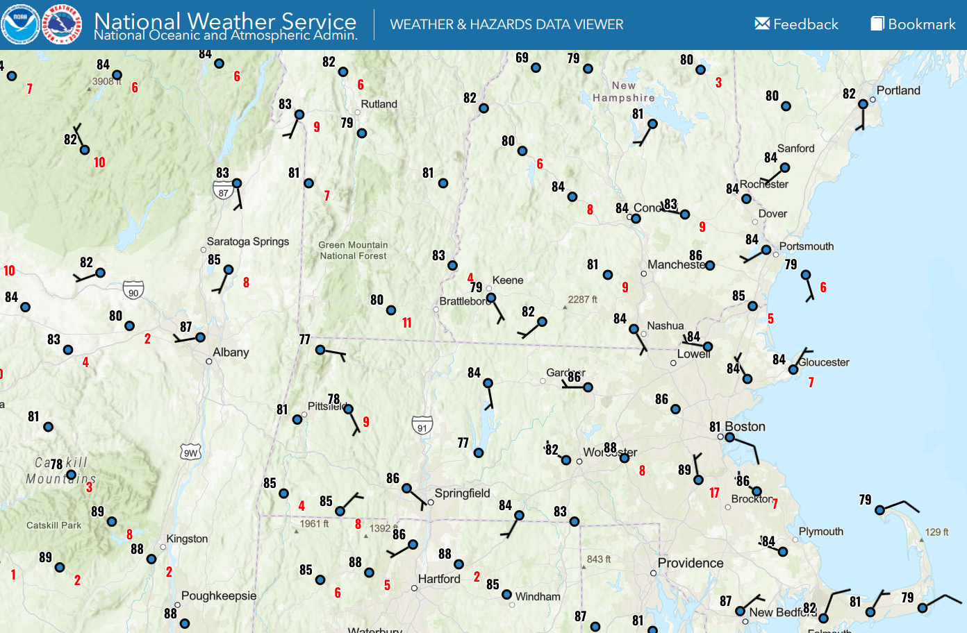
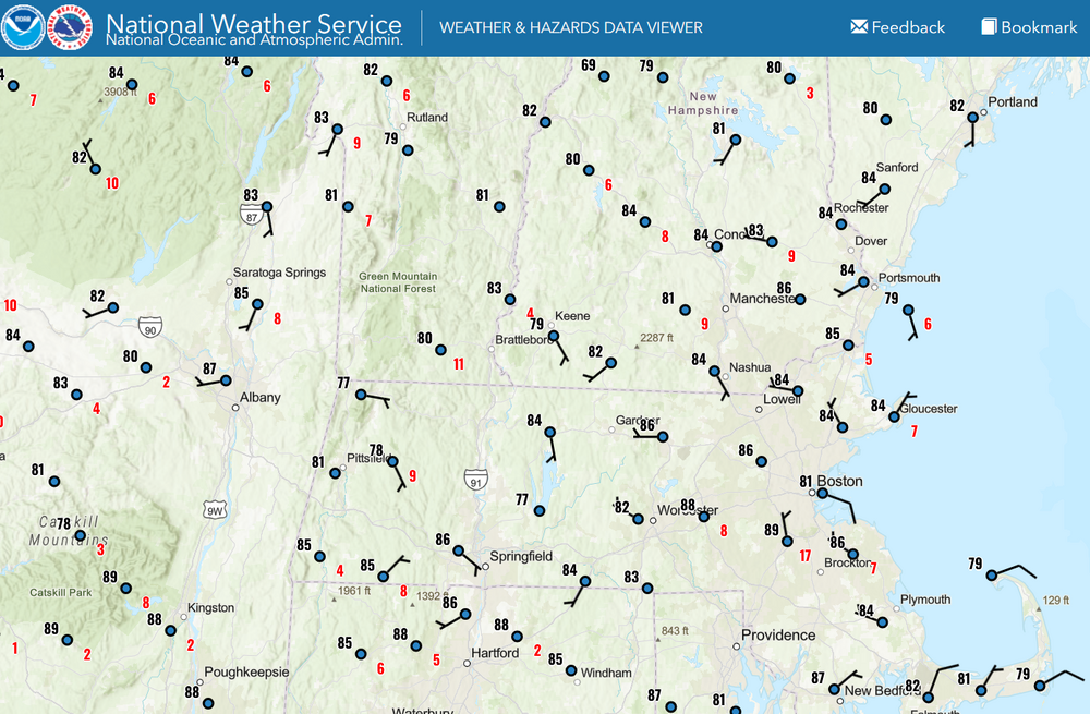
NAM 12z FOUS grid at Logan tomorrow, 18z 30000391714 -3499 132715 82 35 26 18 The last time I saw a vertical profile of temperatures like this ( they're in degrees C, from left to right corresponding to the 1000, 900, and 800 mb levels), was 36 hours prior to the heat wave in 1999 - which actually ... the next runs backed off. This was back when the NAM was not yet the NAM. It was it's predecessor known as the ETA. That 1000 mb T of 35 C is going to be 39 or even 40 C at the floor of the BL where explosive thermal overturning between the air and surface(s) constitutes the actual 2-meter temperature there. In lay terms ... 39 ~ 102 and 40 ~ 104
-
You know... I dunno sometimes it seems sort of self-indulgent to run AC - in my case, the mini split sys. Yeah, it'd take care of it and I'd be all comfortable but I cannot stop myself from considering the ‘physical mathematics’ of it. What's the expense. First of all, cooling the air in here asks the grid for additional energy. The high efficiency of the mini split system, notwithstanding, it's still requesting the grid to provide. Which, generates that power (ultimately) by releasing more green-house gasses. In theory, this adds heat to the surrounding ambience' unrelenting efforts to raise the temperature inside the house ... Thus, the mini split automation necessarily works harder, and in doing so ... asks the grid for more energy. And one can see where this is going - feedback loop. Now, imagine that all households that can, are, doing the same ... to mention the enormous total load requirement when thinking about the total residential and non-residential environmentally controlled environments... suddenly, this is not such a "cooked" up morality issue - it really should be. To combat this cognitive dissonance … I find myself enduring the heat as long as I possibly can. I just looked at it and 80 was the point at which bead of sweat evidenced itself … at that point I figure it becomes a health and safety priority in the here-and-now. To make up for it though … I just don’t run the cooling setting on merely pedestrian summer days that often.
-
what's the ML lapse rate ... It's not really 'wasted' to me, if there's no acceleration anyway.
-
Yeah, today's got what I call "garden site" ( basically means any site not calibrated by NWS standards) DP written all over it. You have basically still air failing to mix away exquisitely efficient evapotransporation off foilage in this heat. There's probably a DP bubble over every individual lawn for that matter.
-
it's almost like it's just sync aligning the response circuitry. ( like wtf does that mean?! haha). I mean, first the 500 mb responds. Because it is free atmosphere, ..which physically means it would respond to a heat surplussing first. etc... But, the ensuing circulation forcing then constructs/effects in the ocean patterns of wind-SS stressing. The heat aggregation regions emerge. This may look like a positive feedback? But technically it would just a response tapestry. Hard to say... there's definitely a lot of a "emergent" properties due to the immensely complex interacting forces that are also in themselves, in a state of delta. It's kind of a having thousands of 3-body problems, the result of each one, then resulting in a new 3-body problem ( metaphor). What looks like cause and effect, may in fact be more synergistic - sort of where your intimating. What I'm saying above is kind of lineary cause and effect, then casting an allusion. It's all conjecture. Part of the problem is that there really aren't discrete boundaries between these systems. The do effect one another, while also heating differentially both among themselves, but wrt one another in a "quasi" coupled way. The devil lurks in Quasi Anyway, getting into the details of how/why? good luck. But I do suspect that thermal memory, which is coherently observed in Quantum Mechanics and nature and ...basically reality, plays a role there. And I don't disagree with the notion that heat dispersion mechanics out of the tropics plays a role in wave mechanics at mid latitudes.
-
Left field thought ... .. I wonder what the local coastal estuary and beach water temperatures will be like next weekend. After these low turbulence heat/compression atmosphere days works over the surface water, while there's high solstice sun - then if we do get a light onshore wind field Thursday into Friday, that will then draw the surface bath to concentration at the shores. That top 6 to 10 foot of SST may get bootleg inflated for a time. Then just imagine... we add is some splashing of 10 year olds in 4' of water? ... the mimicry of seal bate will be off the charts. We could even set off a feeding frenzy! Heh, how apropos on this 50th anniversary week. And it's even the 4th of July next week, the same holiday weekend depicted in that film.
-
90 at KOWD at 10 (but by the time I snipped and pasted this they clicked back to 89) that appears to be the exception rather than the rule. The hottest sites are 86 to 88 but I'll give it the obs through 10:20 out of fairness to perturbation physics ( haha). I know you have Plymouth but I like this NWS product that KGRR's office hosts, too ... most are 84 however, excluding obvious inversion and/or elevations. Hot day
-
Very weak gradient in the region may spare shores by allowing the sea breeze to claim .. even some distance inland. Noticing Logan kicked around to an ESE and no heat out there... It's feeble. Doubt flags are even wobbling much west of Back Bay, but as we warm the interior that may press inland. NAM nailed that idea for BOS in the FOUS grid actually. I was wanting to geek out and test that and here we are. Wonder if we even see a bit of a breeze boundary on some rad products in the afternoon doing that thing where it's side-winding slowly inland. Anyone west of I-95 has no hope for relief. It's now 86 to 88 at most garden sites ( in between the NWS obs) and some of the NWSers like the Oxbow site on Rt 2 are already 90 - sorry read that wrong, 86, but that is typically a hotdog. Anyway, there's so little gradient we're not getting any natural ventilation.
-
86 by 9 ... not bad. Today wasn't supposed to kiss a 100's nuts anyway, but we'll also see where we are at 10. "90 by 9" ... "10 after 10" I like those two, but I've always thought that 90 by 9 sets up 10 by 10. Like if it's 90 at 10, it was bear min required, but 90 by 9 gives you the option of an aberrant alto stratus plume ( like now ...heh ) coming along and parlaying a 99.4 for a high later in the day. If you do that at 11am, and it was 90 at 10, then 10 after 10 seems more likely to fail... 97 to 99, in this very delicate, very intolerant setting or else it fails region.
-
I've always suspected a bit of Mandela Effect with that 1975 heat. There's a couple of factors that ( I feel -) play into that being remembered as something more than it really was. 1, the preceding 15 years saw fewer notably hot summers ( as far as I can find ). This may set up civility with a bit of acclimation bias. Such that making triple digits would sensibly stick out. As Brian pointed out, PVD 104° and BOS 102° that fateful day were impressive ( no intent to downplay that significance here ) but we did comparable readings July 2011. So in terms of significance, I'm not sure 1975 August is more. 2, the 107 ( suspect ) reading then plays into that sensible bias; at a society scale, there weren't any efforts to refute the 107 number/instrumentation second consideration ... etc. So, given time this myelinates the memory.
-
It's call thermal memory associated with climate change ...
-
The heat wave is destined to break down .. obviously. That statement appears to be over selling tho. We’ll see but the thickness don’t fall below 570 behind a “weak boundary” - they’re right about that much… . Thats pretty warm and actually modestly above normal in that particular metric the whole time period averaged. There would likely be ocean modulation for eastern zones but BN may be a bit of an oversell inland in Thu/Fri. Winds also veer back s-SW by Sat and Sun. Aside from… nighttime lows will likely remain elevated if that geneal synoptic regime played out that way.
-
Smokin'! that 12z NAM turns the dial on Tuesday. Jesus... about as hot as I've ever seen these grid numbers, and this is actually 00z Tues( 8pm Mon evening) 60000483310 -0494 132911 82342616 60000392512 00997 153109 82352716 that 34C is good for 37 in the 2-meters... so, buck-2 probably between 2pm and 8 oclock, and probably historic. I don't think the 24th of June is particularly tough to beat anyway, but how about 900 mb level with 26 and 27 C's ... This is pure heat.
-
I feel like two things will happen today ... ( wait, do you mean today or next Sunday ? ) anyway, for today, temps will be adjusted down and the heat warning or advisory whatevers will be cut back... but then at 4 pm, we will have squeezed our way to 87/75 such that the HI's are still like 99 or something, anyway haha...
-
Let this be a lesson to the Met community ...these things always curl deeply/gauge backward into rising heights.
-
Watch it be 70s 100s heat and destruction heat 100s 70s the next 4 days. 0 heat wave with severe impact
-
Radar looks like 70s/light rain Sunday wah wah wahhhh
-
Im wondering how the rest of the summer will be. I’ve seen this several times since 2016 … we get a heat surge in the last week of June/first week of July … then the rest of those summers relaxed back to an uninspired temperate boredom really. Onward to a no show hurricane season then a gradient saturated piece of shit waste of time winter If we reset the dial on the solstice, “suddenly” we’ve seen this before.
-
This sounds remarkably similar to the environmental circumstances within which we had that severe event here 2 weeks ago.. Same time of day... seemingly nil SBCAPE ... but a pocket of EML was tapped by a small cell that then nuked Although surface based instability progs at that time of day are essentially nil, steepening lapse rates aloft support nearly 1500 J/kg of MUCAPE with increasing effective shear to around 40-45 kt, a shear/instability space which could support embedded elevated supercells above more stable sfc layer.
-
Stunning out there ... 81 F with late day summer solstice sun, and wind ventilation pushing warm air is really earned after some of those god forsaken days of May
-
so it's made it to 81 F here same next door at KFIT.. It's a weird combination getting these canopy leaner wind gusts at that warm of a temperature. ...just anecdotally.
-
Same page ... This has evolution room, tho. It's really almost ideal. So we'll see, but for now. If it's 98/72 ... it's not going to make any difference if it's 101/72 save posterity perhaps. Also, many times I've seen big heat, for 3 hours in the afternoon the 72 DPs slip to 66ies while the temperatures are at apex.
-
Occasional Thoughts on Climate Change
Typhoon Tip replied to donsutherland1's topic in Climate Change
no shit ( bold ) I've started bringing this observation up about 15+ years ago actually ... long before it even showed up in papers, that the HC was appearing to be enlarged(ing). I have been relating it to winter gradient steepening and the observed increase in basal geostrophic wind velocities - also the jet cores them selves have quickened. Lot of air-land speed record on west --> east flying commercial air craft over the Pac and Atlantic flight routes in the last 20 years. Anyway, it's effecting storm morphology... and precipitation distribution as well as frequency in the winter. But the cloud aspect ... yeah that's interesting too. -
Euro's been having increased run to run variability on details with this week. still, the ens are about at the ceiling for the means. I'm wondering if this doesn't have an extra special sauce with it and the models might or might not even see it - Oper Euro looks lagged/too cool on Monday - may be a mixing issue
-
I liked your idea of a feeble kind of onshore wind unable to really cool beach/shore roads down much below 87 or so, while the baseball fields just inland have EMTs hauling heat victims away... (well, you didn't say that but I'm havin fun with it ) This could also be a great way to draw sharks closer to the Atlantic side swimmers, huh.