

Typhoon Tip
-
Posts
43,698 -
Joined
-
Last visited
Content Type
Profiles
Blogs
Forums
American Weather
Media Demo
Store
Gallery
Everything posted by Typhoon Tip
-
Active mid December with multiple event potential
Typhoon Tip replied to Typhoon Tip's topic in New England
Nuanced stretching still hinted and in order to do that it robs from vertical motion ... -
Active mid December with multiple event potential
Typhoon Tip replied to Typhoon Tip's topic in New England
It may in fact be noise ... because at this point, relative to what this thing has to work with, it’s got nowhere else to go but less ... I mean it’s maxing out what it has to work with already so anything else has got to deviate that direction. I don’t see how we can ask this system squeeze out more based on what she’s got going in -
Active mid December with multiple event potential
Typhoon Tip replied to Typhoon Tip's topic in New England
You know ? it's almost like if the storm were a little weaker, it would be better - hold on hold on. let me s'plain it. If it were weaker, we could still get a 6-8" band to about the Pike with 2-6" to Rt 2/SE NH... then, the wind on the back side doesn't bend/back around into an NVA subsidence and drying ... We'd probably sustain a feeble 800 mb easterly jet with all that mid level winds still troughing underneath our latitude after the event, and we'd have another 18 hours ( probably ) of currier&ives ...or even that 1.25 mi vis saw dust you sometimes get... It would prolong the wintry vibe - But it does seem like we get a moderate ( easily ) to perhaps top 20 Dec event ... that clears starlight by mid evening. -
Active mid December with multiple event potential
Typhoon Tip replied to Typhoon Tip's topic in New England
good humor but .. there is a matter of perspective. The GFS was actually the first guidance to flag this space and time as containing an event of interest... ? That does count.. The others caught onto the GFS' invention and ran to the accuracy bank with it.. leaving the GFS - so it seems.. I mean it does seem unlikely ..but this thing could still bust S-E and be a NYC/L.I. CT/RI and Cape thing ... You know, there were a couple of big storms in the 1985 thru 1990 ...back before modern refinement of modeling tech, where painful SE correction happened within 6 to 12 hours to go before event entry. Proooobably not happenin' in this day and age - no. But, this is still 3.5 to 4th period technically so ... we could bump 50 miles a run starting at 00z and suddenly the GFS is wrong for coming N - wouldn't that be an ironic kick in the nuggets. Ha... But anyway, fthe GFS was really pretty good at D9 to 11 range... It just seems for the time being that couldn't get out of it's own progressivity bias down the stretch ... Matter of perspective, if there is a boxing day wave in eastern N/A... that run counts as a ballsy call - -
Active mid December with multiple event potential
Typhoon Tip replied to Typhoon Tip's topic in New England
Thats where the juice is, makes sense to sample it although the budget must be shot after the season we had yeah... yet the assimilation(s) are supposed to be sufficient between Japan and California... ..I don't know, I think Satellite should electro mag resonance can see the moisture content as sufficiently packed layers for a region as small as the Gulf when we're above the 95% tile out in the Pacific - doesn't seem to add up as explanation but fug it - -
Active mid December with multiple event potential
Typhoon Tip replied to Typhoon Tip's topic in New England
wait what ? why the Gulf - you do mean the Gulf Of Mexico? not sure I understand that as a sonde gap - ... hm, was there discussion offered as to why - -
Active mid December with multiple event potential
Typhoon Tip replied to Typhoon Tip's topic in New England
I don't see a problem with Harvey Leonard's rendition here - what am I missing? As far as "pope" - you know ..I can see his misgivings on this ...lord knows I've had them - particularly early on.. But, my personal notions on this changed, and I described those pretty clearly already earlier in the day - not that anyone asked.. lol. But seriously, I don't think anyone should be derided for an outlook before anything has actually taken place. I will say though ..from where I am sitting, the 300 mb "INCREASING" jet flow exiting E away from CNE on the polarward side of a SW 500 mb 100 kt flow that is rising up and over a nascent polar air mass 1.5 deg S of that latitude over SNE... is not the deterministic models overdoing it and I disagree with Taunton or whomever wrote that ... It is likely why/where that RGEM's incredible chart topping frontogenic band is coming from - CSI wedgie from hell and don't be surprised at 4 or even 5" per hour rate somewhere and some lightning blinks...in the vicinity/under that region. That is clockwise rotation of sick, sick difluence pulling up an already conditionally unstable theta-e rich source ... It's a snow machine...sorry - but I'm looking right at these synoptic parameters and it is what it is friends - If it doesn't happen..it doesn't happen.. but maybe afterward we can prove these features didn't set up - because if they do... I don't see how an excessive band won't materialize... -
Active mid December with multiple event potential
Typhoon Tip replied to Typhoon Tip's topic in New England
Might as well just post this then... -
Active mid December with multiple event potential
Typhoon Tip replied to Typhoon Tip's topic in New England
Whatever happens... the cold is winning in this situation - period... That high and that hygroscopic density working together will absolutely pin a CF in SE zones.. Thinking KTAN then collapsing SE... In fact, if this thing were to deepen more than current progged, the sub -geo goes more N and said CF ends up collocated over the Borne Bridge - You cannot put a 1035+ nascent arctic/polar hybrid high in this consensus -modeled position and have any warm air intrusion - it just is fluid mechanically impossible without 80 kts of S flow at 950 mb or something Jovian like that - -
Active mid December with multiple event potential
Typhoon Tip replied to Typhoon Tip's topic in New England
I provided a link a bunch of pages ago... but here it is again: https://www.weather5280.com/blog/2017/01/05/what-is-conditional-symmetric-instability-csi/ It's in there... it offers a run down topically that doesn't require a thesaurus ... but you may have to do some secondary look ups, sure. -
Active mid December with multiple event potential
Typhoon Tip replied to Typhoon Tip's topic in New England
Re-iterating.. the NAM is likely already seen it's NW most position and that behavior ...and 'probable' settling back SE some fits rather nicely into its own model-climate. It brings them on board at 84 and 60 hours ... and has them over amped and situated ( typically..) NW of trustier guidance ...then, slowly comes back to pack consensus at intervals < 48 hours... It shave QPF too ... I've seen it halve the 60 hour QPF in near terms in some case... Not saying that's happening here - this event seems to be maximizing a couple of physical mechanism so..over achieving for that.. .but, should these runs start coming SE it wouldn't be a shocker... -
Active mid December with multiple event potential
Typhoon Tip replied to Typhoon Tip's topic in New England
And there it is again... of all there has been displayed, the notch has always been there -
Active mid December with multiple event potential
Typhoon Tip replied to Typhoon Tip's topic in New England
Sick of seeing this ...gotta comment on it - want it out there before whatever this thing scores, in case it doesn't for a some scorned winter lovers - That notching in the QPF/ .. related snow products? Don't ignore that - It's real in this situation. Folks are discussing the 'hygroscopic theft' of undercutting 10 F DPs underneath ... well-enough .. but, taking all these Kutchera this, and model-centric snow product that, and blending them, clearly shows a barrier jet axial dry tongue eroding into this this...and I know why - it is because the snow genesis is high up in this scenario, and that is affording a lot of evaporation in that barrier axis, ...where the restorative interior jet is organized from interior D.E. Maine and points to the Worcester Hills -... The Boxing Day storm was a latter correction and we didn't really have time to steep in this fore-shadowing of that event, but there was a clear notching phenomenon that really was guite similar to this back then, that I personally did not take into consideration and dismissed it as noise.. Well, we didn't do so well in that system, despite any notoriety - ... We ended up with 4 or 5" of arctic grits ... drifted against opposing curb slants and finned around tree trunks and tires of cars, with not much on exposed ground from that, where 20 to 24 " jackpotted S of here... and N. Middlesex was targeted by the barrier jet dry air hose in that event ... this looks similar to me.. . Don't be surprised if there is a hygroscopic shadowing in a dearth band here in the interior up through S NH.. This sort of/said notching like below began showing up two days ago and it's been a persistently recurring illustration since...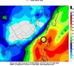
-
Active mid December with multiple event potential
Typhoon Tip replied to Typhoon Tip's topic in New England
Sure ..good question... Conditional Symmetric Instability in a quick Web look up should be sufficient to elucidate that phenomenon? https://www.weather5280.com/blog/2017/01/05/what-is-conditional-symmetric-instability-csi/ This excerpt here, from that source, nicely fits this overall scenario ...etc..etc.. there are other hints and discrete aspects that also fit ...which I will leave to your devices.. "... the vertical profile must be at or near saturation. This is where the "conditional" portion of CSI comes into play. Also, note how the winds are turning clockwise, or veering with height. A sounding like the one below, if observed on the southern side of an upper-level jet streak, could be an area where the release of CSI is possible. .." In this case, we have a 500 mb SW ...100 kt wind that is turning E at 300 mb over CNE over the course of the event... and the column is going to be saturated with that pwat/S stream air riding up that frontal slope and taping into the environment... ...not gonna re-iterate but you get it. -
Active mid December with multiple event potential
Typhoon Tip replied to Typhoon Tip's topic in New England
I feel the move by BOX to expand was probably a good call this morning .. I would extend the watch into southern VT/NH/Lower Maine coast too.. The thing about this that has me suspicious for a significant impact scenario - albeit perhaps tapering, which is an unusual result relative to the gestation of the climatological Nor'easter ... - is that there is still some 80 to nearly 100kts of 500 mb jet max riding up and over the polar boundary interface/or immediately astride on the N side of the best perceived lower thickness packing that will approach extremeness somewhere within meteorological shouting distance of a WSW/ENE axis near the S. coast... Dec 2005 rings a bell ..even if it is not really in a very good total analog space for this.. .. Both had/modeled a similar very compressed thermal interface along or just S of the S.Coast...with wind max at 500 mb moving about 50 or 70 or so miles on the polar side of said interface. Why that is important is that packed thermal interface means an upright elevated frontal slope, such that maximizes UVM proficiency for any entrained parcels... A nexus of pseudo-adiabatic destablization from latent heat release/buoyancy from/during cloud explosion ... then being augmented further by superior Q-v forcing by said exit-entrance jet acting as difluence running by just to the N... This is a positive feed-back for lift. That's a lot of long words to describe this being uniquely capable of over-producing ( or in this case, performing on par - amazing!) when we have the these physical parametrics overlapping - I would also be looking for CSI.. or quasi CSI banding and thunderstorm activity too, maybe more so NE PA/ N NJ and White Plains NY ... but if James' ( tm his warm front ) 10C dt/dx really does line up across a mere 50 miles ... some of that can't be ruled out as enough mechanics "appear" still available along the Mass Pike... feeding off CAPEd air if that were not enough... This is a S/stream theta-e potent air mass being forced up a steep ascent and the synoptic evac ... and it doesn't stop there.. because I am noticing the right exit-entrance emergent jet at the 300 mb level is over CNE ... and that's sort of completing the circuitry ... Just as an 'index finger rule' ( too ...) we were always taught in the 1990's up at UML ... you tend to look for 1.5 D polar side of 500 mb wind max trajector for snow climate and even the GFS has it's wind axis cutting across the L.I. S and tho these general rules are made to be broken... mm - I could see region Amherst to BED, MA type axis doing interestingly well in this - -
Active mid December with multiple event potential
Typhoon Tip replied to Typhoon Tip's topic in New England
Personal experience with the NAM: It's passing thru classic 'NW bias' intervals for the next 2 .. 3 cycles. Thereafter, it will likely receded a couple lat/lon ticks SE ...but also shave some of QPF - ...which, I am noticing that despite other observers speaking of stronger overall synoptic evolution thru/by the region, the latter has already commenced ... part of that is systemic bias correction, but also, par of that is owing to its axis of band-back "quasi" trowal/WCB termination over cold dome, as being position NW too. Probably less than fun to try and separate those. The 0z and 6z runs were nearing 2." liq equiv+ at Logan ( for ex..) and this run keeps that location short of that number. That said, it is upping the totals at ALB over prior guidance... so there are two aspect going on, (some systemic bias correction + position differences)/2 ... effecting snow totals and QPF and so forth.. Bottom line for those using the NAM ... ( hopefully no one at intervals beyond 36 hours without a mischievous grin ), future cycles probably bump said axis' SE and take maybe another 1/5th of QPF ... which, isn't even saying either is correct - just that it is my experience that it does this moving through intervals < 60 hours.. Otherwise, it seems this run from orbit is showing what the other models are... a tendency for deamplification of the total wave space as this event is leaving... The NAM is slower to do so, where as the other extreme.. .the GFS wants to do so at least excuse imagined - I mean, it's like the model heard that a memo 'might' be written that allows it to do a-b-c, and before the others even got to read it.. it's already onto d-e-f .. That's sarcasm for the GFS is too fast to decay the kinematics ... probably ( tho not certain ), at the expense of it's own accuracy in this case... We'll see.. But, this - I think - explains what/why some of these more recent layouts of snow totaling/consensus is for the max out there NE PA/SE NY ... then a trailing off ( at little less climo-like for coastals storms in cold columns ) along the same axis nearing central MA ...etc... It's because the total system is losing mechanics during ... So when a major model refuses to budge, the end result will invariably demo that some vestige of "why" is evidenced - even if the model in question proves more erroneous over all, you can "see the point it was making" ? well, should that play out like that... that's the GFS' echo in the outcome... I think this is an important concept and philosophy during this era of models not actually controlling the future weather ( like a sci dystopian future lol ), but still being imperfect -
Active mid December with multiple event potential
Typhoon Tip replied to Typhoon Tip's topic in New England
Snow machine look -
Suggest watching the 21-23rd period
-
Active mid December with multiple event potential
Typhoon Tip replied to Typhoon Tip's topic in New England
Lol. Geez. Yeah I feel pretty confident the GFS is prematurely stretching this thing-...you know pulls the x-coordinate cuts into it velocity momentum. It’s got to borrow it from somewhere right? But reducing that mid-level momentum is definitely going to weaken that 700 mill bar surface underneath it and there we go - nooOO storm for you ONE YEAR! -
Active mid December with multiple event potential
Typhoon Tip replied to Typhoon Tip's topic in New England
Also the ambient surface pressure around this thing is a little bit higher than normal specially with that big dome sitting next door… So when you’re looking at 1000 mill bar low pressure core think 992 ~ in a more normal pressure distribution. In other words the winds may actually be stronger than is typical for a low pressure 1000 mb deep. The NAM grid has 30 knot sustained middle boundary layer flow coming into Logan with 1002mb underneath and I’m going oh -right -
Active mid December with multiple event potential
Typhoon Tip replied to Typhoon Tip's topic in New England
My guess is the 500 mb wind max dampens over top? -
Active mid December with multiple event potential
Typhoon Tip replied to Typhoon Tip's topic in New England
See… the GFS has a speed bias. It’s subtle but real. But a model that carries on with that sort of tendency would see this kind of shredding scenario at least excuse to do so - put it this way ...it’s like it “enables” its bias? I think so and I think that’s why it’s almost unable to slow that down. But we’re seeing as we’re getting closer now 60 hours out a subtle improvement; I think we’re going to see that more so going forward clicks towards the euro. I don’t know if it’s gonna go all the way to the NAM or anything like that crazy but - -
Active mid December with multiple event potential
Typhoon Tip replied to Typhoon Tip's topic in New England
Yeah GFS has been trying to speed up the rate of decay of the short wave… I’m sure you know this but most models see it as completely absorbed into the flow and losing identity all together by 48 hours leaving New England ... it’s just the GFS wants to do it right away with instant gratification-LOL -
Active mid December with multiple event potential
Typhoon Tip replied to Typhoon Tip's topic in New England
This has always been precarious… I mean that’s a foregone conclusion and built in. I’m curious what Chris ( Occeanwx. ) thinks… He mentioned this 0 z cycle as crucially losing sensitivity issues related with being fully on board for the full cycles and shedding the old signals out ...remember we only need to flip a degree or two polarword and everybody gets cashed in. A goodly bit of the storms morphology has always had the look of dependency on I ts own in situ mechanics as described and discussed at length yesterday -
Active mid December with multiple event potential
Typhoon Tip replied to Typhoon Tip's topic in New England
60105968913 15318 130430 32999395 That is NAM gridded data for Logan... ~ 10” in 6 hrs in sustained 30 kt wind at 29F Looks like 2” in the intervals right before that ... That’s as far out as the grid goes ... 60 hrs. Prolly significant more looking synoptically at the interval after ..Guessing another 4-6” by the look of it. Jesus. 12 hrs of mood flakes after. Maybe longer. Wow region transforms into deep winter


