Typhoon Tip
-
Posts
44,217 -
Joined
-
Last visited
Content Type
Profiles
Blogs
Forums
American Weather
Media Demo
Store
Gallery
Everything posted by Typhoon Tip
-
It's funny you tossed the ICON into that comparison ... I don't really use that model - I gave it chance over the last two seasons and wasn't ultimately impressed enough to use it outside of a day...day and half. To many critical albeit only seemingly too small to matter reasons to ruin a clad forecast for me to bother - lol. That said, I do eye-candy it from time to time out of morbid diabetic practice ... it's been pretty sweet on the Saturday heat for week actually.
-
Is that a personal observation? Not busting nuts ... curious if that's documented. I did not know that. I was inclined to think it was just different moisture presence in the column in most cases. Which ...yeah, conceptually that can be vertical mixing related. But I was thinking that way because I remember the 2018 version of the oper. GFS's handling of that March Nor'easter, where it had that 39/32 column, at 98% RH, thru 3.00" of QPF... We've discussed ad nauseam -. So, we are a couple of upgrade releases/great grandson years late, and probably(hopefully) that sort of stuff has been un-mucked. I just sort of assumed there's a recessive trait there nonetheless- But yeah...I guess it could just be mixing too.
-
I mean... if the Euro wind field were to rotate/correct W ...more in line with a GFS trajectory, whilst keeping/conserving its other modeled metrics/verify ... yeah, I wouldn't have problem going 101 in the parking lot of the Burlington Mass/Mall, or sitting at an eternal red light on Rt 9 out in Natick... I mean with 22C mixing from Venus like that after several hours of full torch sun, the "real" ensuing 2-meter will ping that high. Clouds? Yup.. when we get into the post 95 VIP range, ... the clothes have to be clean.
-
Yeah this is a good take, Brian - if then getting down into 'local studies' scaling, there are little 'climate pockets' that will perform like that where circumstantial - like the d-slope this, or the drying sending the T side of 'T/TD' soaring...etc. Thanks for these... The Euro, we can see the southern marine there pretty clearly/as suspected yes. It's not as 'visible' but it probably keeps the the temps to 95 or < even as far N as southern NH ... certainly possible. Contrasting, the GFS has less of that. It appears to maximize a big heat result, despite the core of the hottest 850 mb plume escaping S of SNE ...interesting. Looking at the synoptics more closely, indeed it has more westerly orientation with the flow. Not hugely... some 20 deg of dial angle but that's probably enough to suppress the contamination - guessin' What are the DPs in the RGEM vs the 12KM NAM? That NAM ...I wonder if that's a bloated theta-e artifact. 84... okay haha
-
Also - I did not include the GFS in that 00z "hot take" on Saturday. It seems to be inconsitently placing the eject 850 mb air layer in space and time over the last several runs. It's also been inconsistent with the 500 mb 'idiosyncrasies' with the orientation/morphology of the non-hydrostatic heights...It just wants to ablate and rasp the latitude of the warm potential at least excuse, which I am not sure given the large scale -EPO pulse and down stream coupled vortex I outlined, that the GFS has the right idea. That said, it could verify... and miss the region south - in which case the standard SW flow/climate hot day results.
-
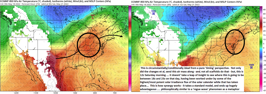
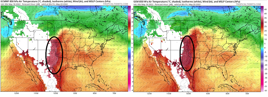
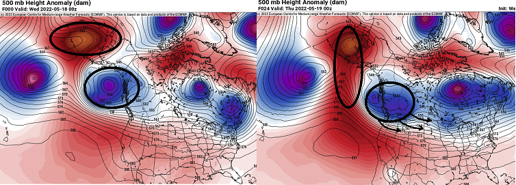
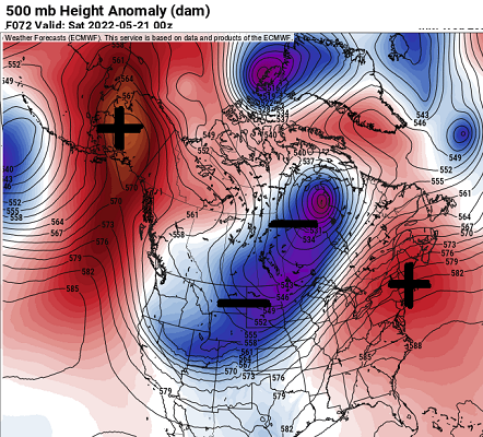
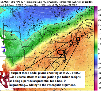
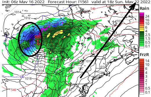
I realize not all of us in weather social-media hobbysphere covet passion on the summer/heat side of the preferential equation ( lol...), but seriously, I am not intending to troll by writing this up. At this point I am willing to agree more so with Metagraphica ( think it was...) re the potential to break records on Saturday. Prior to this, the synoptics suggestion was there, ..but particular details were not yet emerged out of the coarse trajectory/set-ups that lent as much confidence. Those appear to have come into better focus rather neatly over the last 24 hours of mode runs - particularly more so in the Euro and GGEM. More on that below ... and for the general audience ( I used your post as a victim to launch this synoptic overview ... because I have a life that is otherwise so richly and spiritually worth existence, clearly ...) First, an aside: perhaps by virtue of the fact that May records are more vulnerable, helps? It's bit of philosophy, but one that takes acceptance ( at minimum) that synergistic feed-backs that cause large heat eruptions have become increasingly more common place over the last 10 years, globally. These occurrence will likely come home at some point - Brian and I have been going back and forth about this aspect, and the idea that we really haven't had a Pacific NW event year. Perhaps 'yet,' being apropos. Not to alarm either - not saying that's ring the door bell at the end of the week, either. But, there is now more clearly/likely, going to be synoptic confluence of metrics that can take an ordinary/seasonal hot synopsis, and end up over producing. It's actually rather elegant. So ... engineering a historic hot one: Observe this annotated series below. Contained are the 48 hour ( from 00z 18 May ) Euro and Canadian (GGEM), 850 mb temperatures - c/o Tropical Tidbits. That white 'checkering'/migraine aura loss is likely the topographic blackout/grid, but it only partially obscures a very intensely energized kinetic air layer. That happens because the ambient elevations is so high, the 850 mb is closer to the ground - thus more proficient at conditioning the air mass at this time of year with very high, unabated solar incidence with the ground...etc. Meanwhile, over the next two days lead, there is a moderate -EPO burst - I'll just show the Euro as the others/ens means concur. This annotated series below is intended to imply the animation/sequence of events ...where the -EPO comes into form. Concomitant with that geopotential height anomaly over Alaska, immediately downstream we see a vortex, a coupled balancing mass, which is in the process of being kicked down stream by the manifold of change taking place - c/o Pivotal Weather. It is interesting to note, a potentially historically hot day on Saturday, really in indirect essence is because of this interaction/circulation mode forcing illustrated above ...some 4000 km or more afar. So what happens? As the trough above, Pacific NW, continues to then carve S-E, while initially W of 100 W longitude, there is then a transitive/indirect coupling height response over the eastern mid latitude continent ... as typically... within 2 days. Shown below is the 500 mb Euro, again, c/o Pivotal ...nicely showing that moderate 500 mb anomaly ( those height rises over us allow the diurnal expansion from heating room to take place). Note, this is only 00z Saturday. The total progressive character of the flow manifold with tends to break this down; so this charts destiny isn't lingering long. The trough in the Lakes goes on to normalizing in day or so, while the ridge over us, moves into the Atlantic. This allows drills a correcting cool front thru later Sunday...etc. **Below is the most important aspect that prior to last overnight's model runs, was less than clear could transpire. It is the 'timing' of that 850 mb kinetically charge air mass from earlier. The evolution of the NE Pac into/over western N/A, effectively 'dislodges' that air mass. Once that occurs, it is impelled to ride along the circulation eddy et al... Here is 00z Saturday, a plume is situated over the OV (left blw). By 12z, it has migrated to the western New England entry, poised to comes east during the day (right) As this matures on during the afternoon, nearing 21 z we see what appear to be small +22 C nodes, which are some 3 C warmer modulated over the 12z charts above. That's a crucial distinction there. Regardless of whatever the 2-meter temperatures the Euro is calculated at that time, that modulation strongly urges that the mixing depth has actually achieved the 850 mb sigma level. Which means, the adiabats may in fact confidently be drawn from +22 C/ 850 to the surface along a skew-t diagram. That's pushing 38 C at the surface, btw In conclusion. This has an attempt at a minoring synergy to over produce at least one day of extraordinary heat - by that ..I just mean substantially above climate suggestion for a run-o-the-mill hot day in May. The 2-meter at this time ( 21Z abv), from the more recent 06 Euro is only 92 or so over Boston metro. However, the shading/cinema of the charts has definitively warmer than that across S NH. I suspect the SW flow is a fly in the ointment... The Euro is probably using the Long Island/Bite waters to screw HFD-BOS and points SE... sort of capping do to some contamination from those southern marine sources. I'm not sure on that... If the heat bulges significantly ...we could see a local hydrostatic forcing/pressure orient more E and force W wind. Maybe a convergence axis in there with thunder? So ...yes there are caveats. But in order to synergize things have to go right, too. Fwiw, the GGEM 2-meter/hover product at Pivotal floats a 97 or so Metro west to BED/NE Mass

-
Wednesday looks like the cool day... Some sort of flat wave ejection from the Lakes into a leading low theta-e environment promises to cloud over before noon and light rain wet bulbs - how soothing... yuck. Even though this is bust machine guidance for being too cold time of year, that's a candidate for climo in the MOS's to not see a chilly afternoon. I guess a way out of that is that sometimes the leading dry air and modest subsidence can erode the upper ceiling as it attempts to dump over the Berk's and you can get a couple extra reach-around hours of warm sun prior the denser advance finally taking over.
-
Oh.. .ha. I was like, 'He only thinks we're getting into the 60s - I think he means 90s' Anyway, yeah, I know I spent time - for the general audience - penning way too long of a post over why the sort of modeled heat delivery through New England over the weekend, doesn't tend to be 'big heat,' based in no small part on both climate, and just experience with SW flow. By I suppose as others mentioned, wind direction - it's likely to be a key metric. If we can keep it more WSW or W as opposed to NYC --> PWM. But that kind of means its now a SW flow, doesn't it? Thing is, we have a front approaching from the W, with non-hydrostatic ridge/associated wind at mid troposphere et al, SW. So not sure. The 850s on Saturday are certainly pushing it for May pretty hard against the ceiling. Looks 21 C... That's there. But the RH at 700, 500, 300 contaminated to perhaps to partly cloudy. heh well anyway we'll see. I guess whether it's 97 or 93 is nuisance distinction and not worth this energy. haha. I mean, it'll be 93/67 and that combination will roll bottom back beads of sweat into ass cracks either way.
-
? 'building into the 60s'
-
I could almost see it being like that (^ abv), + 1 or 2 ? Just not going crazy is what I mean. I mean...out of respect for the mean modal look, of -.5 PNA while also on-going around that same amount of anomaly in the +NAO. The mode tandem of those two tends to favor S/SE U.S. warm anomalies, and high pressure return flows tapping into that to some punny degree - heh - isn't an altogether terrible idea. We'll see. These zonal progressive means can also break one way or the other... I do sense that the westerlies are a bit over-active/lagging ( perhaps fitting the leitmotif over the last 20 years to do so, deeper and deeper into springs - the models won't stop until we've verified an ALB snow flurry on June 10 lol ). Anyway, eventually the ambient polar jet will likely retreat/break down into summer noodles, and I wonder if there's a big June heat wave out there after this oscillatory aspect inevitably moves into the next paradigm.
-
This region of the continent doesn't typically get big heat from SW flow. Counter intuitive, perhaps, but the region gets more 'seasonal'/climate heat that way. It's kind of expected seeing the GFS/Euro trend away from the 99's, when considering the generally agreed upon standard warm sector synoptics through the tail end of the week and weekend. The big heat, those 95+ to 102's, have a different synoptic scaffolding. You end up in a scenario of light W to WNW wind at the surface, under a NW flow at 500 mb. And in betweeen.. Sonoran/SW heat release air layer has timed it's arrival ( 850 dragon belch 22.5 C) accordingly. In 2017 July, for example, we had the synoptic scaffold as such, but there was no kinetic layer delivered. We did well to cook locally, but boy did that week leave a lot on the table, despite maxing at 98 ( I think it was....). The longer term pattern looks oscillatory in nature tho. The models tend to too much amplitude beyond D7's regardless, but same here.. Warm(cool) signals, either direction, might be more like (seasonal + the unknown contribution of CC polynomial of terms)/ 2
-
yeah ... we speculated last week that this would be an acceleration in the green-up. Back to back days of 80+ might do that in the 2nd week of May. Along this end of Rt 2, I'd say all trees are leafing now, some are 1/4 .. 1/2, ranging to the Norwalks which are nearly full.
-
-
Occasional Thoughts on Climate Change
Typhoon Tip replied to donsutherland1's topic in Climate Change
"..., Overshoot is a future where the world does not cut carbon quickly enough to limit global warming to 1.5 degrees Celsius above pre industrial levels — a limit often described as a threshold of dangerous climate change — but then is able to bring the temperature back down later on. A sort of climate boomerang." I am not entirely sure why the author uses 'boomerang' - she may be apropos with that metaphor, or has something in mind I'm missing? But the whole 'overshoot' and then deal with it later, smacks as a passive engaging in 'bargaining psychology' - perhaps that's we are there as a species along the denial-acceptance arc, but that's optimistic too, if I'm asked... In Psycho-babble vernacular, the behavior has a formal definition. But for brevity.. it's basically when faced acceptance ugly realities, a human (or group thereof) will evade by relying on plausibility to ameliorate the angst they don't want to accept. At some point along the way the consensus of the science community ( and anyone else with arithmetic mentality ... ) came to the easy calculation, or intuitive awareness that 'Humanity will likely overshoot that ceiling' ...above which we are shown the Fermian door ... And that is when the machinery of bargaining kicked in. Because overshoot doesn't sound like an ultimatum? I sounds like room to negotiate for how much or little the overshoot can happen. That may be okay... by some even. But that is not how it will work. Humans don't do that. You give them an inch, they take a mile. That's what happens. They'll push the overshoot further and further... I agree that is a bad idea. It's just my own op-ed -
Likely to be later high temp registry across the area, west to east. BDL bounced to 81 when the clouds tended toward less, and we jumped from 69 to 75 here as we've gone 60/40 in favor of sun. S-N orient band is pressing slowly east - should be east of you in an hour. Light rains within. Then a sun burst 3pm with a spike? something like that -
-
Interesting D9 GFS look... That's setting up a Bahama Blue conveyor pattern, ..yet it has that TS it's been toting lately heading for copulation with that weird anomaly over St Luis - heh...prolly not right but it's interesting.
-
At risk of bunning one's self... you know - it was actually pretty good the last couple of seasons - I personally noticed - wrt extended lead "existence" ... Position in space and time ... obviously, not so much. But just the advent of one being on the map, somewhere, as a very coarse example of model performance, it's been remarkable at times. Because of this [ apparent ] reproduce(ing) decent performance as to whether one will exist, alone, I actually think one will. There's another aspect, a modestly positive NAO phase is as such, modestly positively correlated to western Atl Basin spin ups. We'll have to see.
-
We experienced a much better MCS the evening of June 10, 1987. It prooobably was not a "derecho" per se at the time it came down the eastern Mohawk Trail ( Rt 2 corridor), but if allowed another several hundred miles of continent it likely would have evolved into one. That was a fascinating day boy. Some time between 8 and 9 am that morning in a dead calm wind, light mosquito rains began. You know, the annoying cool rain mixed with those earlobe arias, occasionally slapping that cherished little tickle sing that soon follows. I know, ...because I ventured out at the first sound of occasional soft and/or distant thunder like any little weather dork would. Ha. It was around 63/61. It did that through 11 or 11:30, when suddenly out of nowhere ...that all-too-familiar, 'beep beep beep-beep' pinged off from the television. The slot for the inevitable message appears at the bottom of the TWC's televise. "What? What? C'mon?!" It think at the time it was like the 'Gardening Report' ? Thank god the alternative, "THE NATIONAL WEATHER SERVICE AT TAUNTON MASSACHUSETTS HAS ISSUED A SEVER THUNDERSTORM WARNING FOR: SOUTHERN MIDDLESEX ...." That got me off the couch, soon crashing through the door to front yard... Weinershnitzeling gawks at the sky around, it wasn't initially anything special, though the thunder was more impressive, coming on with those insidiously suggestive lower decibel resonances like a meteor might just have impacted over the curvature of the horizon. You know, that's a special kind of ominous reporting thunder. It is more smooth while foundational, like the underworld warned by a Gregorian Base section. Just then, the the light around dimmed. It was like dimmer switch, soon becoming impressively dark. White noise wind began to rise over the trees, and then ... they leaned all at once. Maybe 40 mph.. sub-severe, but going from calm to that augments the affect. Rain became heavy. Lighting was frequent, but ultimately ...since I was not in fact located in southern Middlesex County, this was not a 'severe' thunderstorm at that location. But those insidious Gegorian evil hums certainly suggested that it might have been a fun morning down in Marlborough - say.. Here's the fascinating part... That was all ending by noon or 12:30 pm, and quite abruptly ... the sun blasted through. The whole murky, thundery wet morning of it all ... packed up neatly and pulled away to the east, exposing the region to the highest sun angle of the solar year in the wake, over a fresh dose of saturated earth and atmosphere for cooking. That was actually just a fantastic recovery. I remember as the rain was ending, it was warming up - aft of a thunderstorm, no less. That was unusual. Thunderstorms are supposed to cool/process the environment. But a day that had begun lower, was by then 68 or even 70/64. I wondered if we made end up bursting out of it - I had a feeling we would end up different by afternoon. By 3 pm, it was 89/76, or something, under mainly a sun sky... The hills in the distance tinted gray-blue through the steamy air. It was like being in a sauna that situates under a rotisserie lamp. I had no idea ... but right around 3:30 pm... an innocuous CB erupted some 50 mi NW of Albany. It quickly developed a bow outflow in front and as that sucker cleaved under that integrated bulk CAPE anomaly, holy hell! By 7pm, a 40 mile wide wall of 50 K over top domed CBs was roaring down Rt 2, with 70+ out flow p-wave blast and probably some of the most frequent lighting that to this day I can recall. I do so growing up though ... in southern Michigan - different stories. It actually came through eastern Mass ... primarily N of the Pike, in three distinct events. I'd never seen anything like that before. The first of the three in the sequencing was a stage show of towering CU. They were obscured by the anvil as it cast over like the wings opening above the demon in "Fantasia," the individual structures completing the symbology as though they were his minions rising from the graves beneath. It was all nearing dusk anyway - which made their bases particularly scary and menacing looking. A few of their turrets punched into the lording canopy anvil above. That's always a fascinating dimension perspective, but the surrounding mammata really added to the outre nature of the scenery. While eerily calm, ~ every 30 seconds, a single silver-blue bolt blinked several times connecting the distance of the elevated anvil to earth - around, but not from, those darkly bishop TCUs. That cast an allusion, those were not really in charge of the whole specter. These were followed by shattered wine-glass thunder. Hyperbole notwithstanding, it was truly awesome, the angry tenor. That carried on for 10 minutes, then the second in the sequence come a destructive pulse of wind. It swept with an immediate acceleration, taking a still air to a hurried fear almost immediately. That's what I mean by mimicking a p-wave off a bomb blast. It down a lot of limbs around town and I'm sure elsewhere, knocked power out here and there. There the pulsed positive stroke discharge act of the show had moved off - this was distinctly different perspective, this wind event. Then finally, the third... signaled it was coming as a line of near the western horizon of constant lightning - or just 'lighting,' period. It strobed almost too frequently, really N. Texans would have said it was unusual. When it arrives with over-lapping flashes of light, a rise in the roar of a new wind came on with sideways rain and est quarter " hail ... This din competed with it, together creating pure energy that took the next 30 minutes to fully return to quiescence. This third way made sporadic power outages, pretty much complete through the area. It was a couple days before restorage.
-
It's hard to ignore the trend to gnaw at it though. 5 days ago, it had that distant kind of omen that one gets when taking in all euclidean measures. But those latter metrics got shaky since, and what was originally like a real 3 day heat wave idea, have become a day-long warm sector. What's interesting though, the flow appears to be about as stretched as the models can possibly be ... without finally having to give up on on even a warm sector and just not allow it in at all... Have the fast, raging progressive zonal flow just oblate the rising eastern mid latitude heights altogether... suppressing to the Mason Dixie or so. If you go to Tropical Tidbits, and click on the EPS' 500 mb height anomaly, click 168 hours ( 00z next Sunday), then clack the Prev button four times, you can see how the ridge is being corrected E. If it corrects much more... it zones out entirely. I figure these modeling tech will finally admit there won't even be a hot day and stop holding on... or, the pattern proofs poorly handled and the heat wave comes back. One thing though, it's hard to make 95+ big heat on one day's notice around here. We need "thermal momentum" usually to get that done. You get an 89'er ...but the low that night is a sultry 76 at LGA/Logan... with 67 warm ground fog over Cranberry bogs. Then it's 94/73 ... low of 79 that night, THEN it's 98. Maybe a little faster, but point being ... stowing from the previous day sets the table. The GFS is attempting to saturate the column with warm frontal shits, zoom to 96, then back down to 72 or something... The period of time is subject to change.
-
Came through E-central Mass as it was dying, not very well reimagined from that artistry above. But I recall being woken by the sounds of the wind, the dawn's light having belated by the advance of the outflow ink. As I stood in the street under that skyscape gawking around ... trees swayed with distant occasional timbre cracks. I saw a 'gust-nado' funnel. Narrow of stature and form, it dangled half way to the ground, sloped backward slightly, like a rope does from a parade float. It moving swiftly over a distant tree-line before vanishing. I don't think the wind really gusted more than 50 mph though, through the whole spectacle, and there was not much rain after. The thunder, distant west during ... ceased before any crescendo past by .. The sun was dimly visible an hour later. What I also remember ... that derecho processed and truncated the heat back. The mid west was incurring livestock and human causalities in a historic heat wave, on-going... In the 24 hour preceding, there was suggestion in the models that for a day, it may surge into the NE - the derecho slammed the door. I wanna say ...there was even a forecast for nearing a 100 later that Saturday... (Chicago was seemingly routine at 105 for days at that point) If memory serves, we only made 94 - the big heat canceled back to PA by the outflow. As a Met student... I was intrigued by the opportunity to be a weiner and experience that mid west heat, and felt that derecho symbolically stole it - and it wasn't even that entertaining as an event unto itself, not by the time that final arc drawn above on the right side of the frame was coming through.
-
The model thinks it's autumn beyond D5 ... That's exactly what you would typically see on a 12 day evolution of a September 10th model run... Warm up followed by faux Sandy analog, with an uber deep trough phase... followed by another ridge way out there. It does this because it cumulatively lowers heights over the polar side/astride the ambient westerlies core as a running/continuous bias... such that by the time it gets to D7, it has some 6 dm of surplus cold non-hydrostatic heights in nodal lows and the ambience in some scenarios - getting into a different matter, but it just adds more jet velocity and wave propagation speed to an atmosphere that already has too much of it. But scooping of that cane and driving it into Maine is embarrassing -
-
It is, but I'm not liking the ens mean behavior. All three, EPS, GEFs and GEPs, have repositioned the accompanying 500 mb non-hydrostatic height axis some 200 to 300 clicks E of previous longitudinal fix, spanning the last three or four consecutive 12 hr run cycles. The trend is so coherent it almost looks like a progressive single model run... If it goes another two of those intervals, we end with a fast cool front and pancaked ridge mooshed S of DAY-PHL. The GGEM actually is the one guidance out of the three oper. version that's appears to have to balls to project a hint toward that possibility. Look Utica while Boston's in the 90s. I mentioned yesterday that the telecon was tepid for a heat signal then, and they still are. I guess all these aspects don't lend confidence. Not saying it won't tend the other way, but there's this hell bent obsession in the models to fire hose a Pac jet across the country like it's nearing Xmas. It's not really conducive to heat domes. Maybe it's just ends up a potent warm sector with typical failed convective threat.
-
PF ...looks like you got some summit glaciators along the Greens... Might be some photo ops -
-
yup... Not bad for this region considering the lead. But, that's not claiming much for the competency and climate awareness of the source lol.
-
Kind of unfortunate. Hate to say... I'd be willing to sacrifice tomorrow if we could go ahead and bust wetter. I don't care/want to get into any stein jocularity - frankly it's tediously boring and annoying... ha. I just don't want my lawn and flower beds to yellow/wither prematurely. My experience with that is, if that happens in May it never really recovers, even if it gets wet later on. Not a lawn care dude. - just sayin' what I've observed over the years.