Typhoon Tip
-
Posts
43,440 -
Joined
-
Last visited
Content Type
Profiles
Blogs
Forums
American Weather
Media Demo
Store
Gallery
Everything posted by Typhoon Tip
-
March 2022 Obs/Disc: In Like a Lamb, Out Like a Butterfly
Typhoon Tip replied to 40/70 Benchmark's topic in New England
You know what that is... ...that is merely missing a S. stream zygote disturbance to fertilize, because if it had that... it would be historically competing with 1888
-
March 2022 Obs/Disc: In Like a Lamb, Out Like a Butterfly
Typhoon Tip replied to 40/70 Benchmark's topic in New England
Now this is a bowling ball !
-
March 2022 Obs/Disc: In Like a Lamb, Out Like a Butterfly
Typhoon Tip replied to 40/70 Benchmark's topic in New England
Here's what's going to happen... The broken line of convection will orient into a linear feature and propagate into western zones later this evening, pushing an outflow out ahead ...and that will scour out this shit ...or perhaps even ride over the top... but it will at least assist in doing so... Then, as the main cold front comes in the aft, it the brief gradient packing ahead will do the rest and there will be a mix-down T spike like 5 minutes before the front goes through neighborhoods ... .... at which time Kevin will either be already asleep, or ... posting how the models were right about the warm front busting in to NE Mass. -
March 2022 Obs/Disc: In Like a Lamb, Out Like a Butterfly
Typhoon Tip replied to 40/70 Benchmark's topic in New England
despite your narrative on the day's proceedings... the boundary has not appreciably retreated back N as a warm front - sorry if reality and empirical data doesn't fit. Don't blame the messenger. I mean ..there might be some mixing along that leading edge there on the right panel ...but that is not attributed to warm fronting. The winds have to go essentially calm where you see the wind is not calm and blowing from the NE with those wind flags - Can't help you. This probably does break down as the main front tied into the baroclinic axis is moving through... You'll get a 10 minute T spike then a west wind or something. If we wanna argue the BD front won't make it to CT, I never said it would. I said it isn't clear whether it will or won't.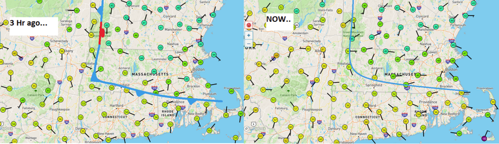
-
March 2022 Obs/Disc: In Like a Lamb, Out Like a Butterfly
Typhoon Tip replied to 40/70 Benchmark's topic in New England
Well well well well... PF finally gets to feel our low elevation, east of the Berks April pain lol -
It's interesting ... - this study really quite exquisitely corroborates my own observations regarding the 'pattern behavior' of the continental circulation mode, of particularly mid to late spring into early summer, over the Ohio Valley, ...through southern/southeastern Canada and the northeast U.S. - as well as the upper Mid Atlantic. These regions, ...usually between late April and the beginning of Junes ( over the last decade ), have experience unusual episodic heat departures, those with higher non-hydrostatic 500 mb geopotential heights associted. However, rather atypical relative to day time temperature extremes, the hydrostatic heights ( referred to commonly as 'thickness' ) are lower. This is reflected in lower DPs, with lower night time lows, ... giving rise to unusually vast diurnal changes due to radiative forcing ( sun ). They don't have to be heat waves, per se? Just lows of 48 with highs of 87 will make the point. 41 to 80 ...etc. Extreme diurnal changes where the atmosphere is kinetically charged, but lacks the moisture input to store latency, ...such that nighttime lows would remain elevated. We don't see that near the coast, because the SE flow tendency is loading theta-e proficiently into these latter regions. I've been noticing this, and suspecting that is the cause, and so... quite refreshing to see this study's presentation corroborate that. What is interesting also... I have posted material, replete with annotations, showing how there appears to be an increasing tendency for ridging nodes to set up near Quebec, as a year -to- year repeating spring theme ( roughly in that date range above). This creates a W wind at locations such as Watertown NY to Burlington VT to Montreal, QUE and further out through the lower/SW Martime, while there was that SE flow coming into the mid Atlantic underneath this nodal circulation mode, keeping those regions from experience higher afternoon temperatures. There were a few years in the last decade, where in one or two events ... Burlington VT was as high as the middle or upper 90s, while it was only 82 to 84 between DCA and Philly... I have a hypothesis on what is driving these circulation oddities... and it relates also to why the NAO domain quadrature of the Annular Mode has been dominating the positive phase state... but that's extends this into another area having to do with the expansion(ing) Hadley Cell.
-
March 2022 Obs/Disc: In Like a Lamb, Out Like a Butterfly
Typhoon Tip replied to 40/70 Benchmark's topic in New England
I'm really saddened that I did not get my resource shit together younger in life ...and/or wasn't born into a trust fund. This is precisely the garbage that Will and I were commiserating over last month, where it's time to book the flight and flee in haste to the 2nd home or villa ...some other place where the skies are painted with tipped cumulus, over short sleeve golf weather. Not to return until mid May, or such time as it is exceptionally high confidence that the weather breaks. Stealing from Samuel Clemens, ' The coldest winter I ever experienced was a spring in Southern New England ' He was talking about the Bay Area, but the sentiment veraciously applies here, too -
March 2022 Obs/Disc: In Like a Lamb, Out Like a Butterfly
Typhoon Tip replied to 40/70 Benchmark's topic in New England
It's really just the bottom 2,000 foot of the atmosphere, too. Look at the spine of the Greens in western VT nearly 60. -
March 2022 Obs/Disc: In Like a Lamb, Out Like a Butterfly
Typhoon Tip replied to 40/70 Benchmark's topic in New England
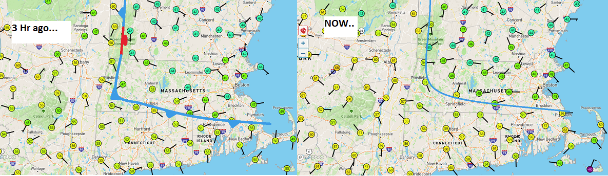
Using the un-official home sites, c/o Wunder ... this is where the BD appears to be right now... Perhaps masked a bit by clouds and morning showers, belaying the temp rise somewhat S-W of the front, but it's close to this Otherwise ...we'd probably squeeze back into the 60s today, and with more DP it'd feel quite a bit different than that destiny N-E of that nasty boundary. The models busted here... It's interesting that the NAM had pulled back on this front in the last 2 or 3 cycles of runs. It kept the wind at Logan S and that did not happen from 06z thru now - not even close.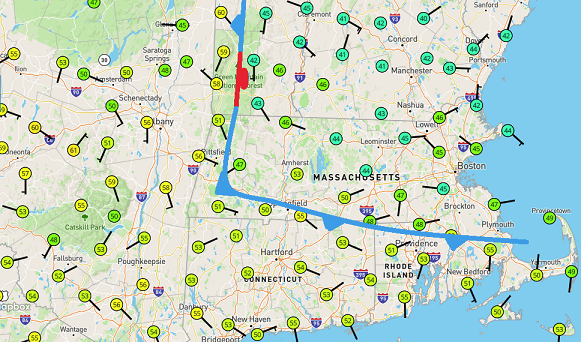
-
March 2022 Obs/Disc: In Like a Lamb, Out Like a Butterfly
Typhoon Tip replied to 40/70 Benchmark's topic in New England
Depends where one is in this murk today. I realize you got a thread going but we ain't gettin shit NE of HFD in this ... and it's not clear this BD won't make it that far, either. Might be safe..not sure. It's 57 there, with modest DP support and S wind... But it's 45 in ORH with NE satan's rhea... This is busting SW as BD's typically do for us up here - as far as I can tell at this hour. I guess we'll see how far it gets. I suppose 'elevate' activity could orange lightning here and there... sure. -
March 2022 Obs/Disc: In Like a Lamb, Out Like a Butterfly
Typhoon Tip replied to 40/70 Benchmark's topic in New England
I am too - not doubt. Sure. But it also depends how deep the blue gets ... I mean I'm not trying to be a condescending dick with the wink there, but I'm sort of put off by shit this morning. CPC was selling us this momentum in the MJO stuff this week, and that it'd likely couple with the La Nina footprint , to yield at warmer anomaly over eastern N/A moving toward the later phases of the month. Frankly, what print - I find that recurring turn of phrase of theirs to be increasingly bullshitty. They either don't know what the f they are looking at ... even as mid-aged Master's holders with years of experience, or they are lying in a 'marketing of significance' campaign ultimately to keep funding their jobs! Because for the 15th time....what happens, the opposite. MJO is dying in the progs now not even making it to phase 5. Weee... momentum - right? Same deal different devil... That has been a leitmotif the last 10 f years and counting, where that technology can't seem to stay coupled with the ENSO, or proves utterly unstable and unreliable. Why are they continuing to sell that coverage/monitoring? That's why I wonder if some of these PDFs are on-going PR to keep their value and salaries going. Heh... okay okay. I'm p.o.ed and exaggerating and being a-hole here ...just bear with me while I vent. LOL ... I'm sure they're all great guys and gals and geniuses... fine - So, the MJO dies... and we just end up back sloshing into blocking after all? It just more than seems we've been here and done this, ...over and over and over ...nth times. It just seems we've also been dealt reverses - I'm almost willing to bet that the moment I click send, the 12z will come out and show it going warm after all. And around and around we go. -
March 2022 Obs/Disc: In Like a Lamb, Out Like a Butterfly
Typhoon Tip replied to 40/70 Benchmark's topic in New England
HFD 54, S wind BOS 43, NE wind ORH is also 45 NE wind... There's a BD between ORH and HFD, and given to the fact that the wind is still blowing actively at the surface, inland in the cold air, it is still moving SW. I wonder if just as the sky brightens and it's looking good for CT, that is when they also get bent over by this pos front. Maybe maybe not... -
March 2022 Obs/Disc: In Like a Lamb, Out Like a Butterfly
Typhoon Tip replied to 40/70 Benchmark's topic in New England
I don't know why this made me laugh - ...maybe because that "putrocity" out the window right now, limps us into conceding that today pretty much doesn't exist. ho man - I kinda warned of this... You know, yesterday was as toxic as it was an amazing as a high. I guess it was one too many gin and tonics, because reality the next morning? We may not see 75 again until mid April looking at the meaningless, no winter gain cold catastrophe that is that weirdly on-purpose piece of shit suite of model runs over night - 'how to get it as miserably cold relative to not snowing.' Sometimes I wonder if psyches would be better off if it stayed head-jammed up ass bad weather until it really breaks for real. I doubt it will improve much here in the Nashoba/Merrimack Valley region of NE Mass as far as today goes. We've back doored and it appears to have at least a little real momentum. The models were hem hawing over this boundary the last couple of days, and then backed off - which I thought was odd against climate, but also because there is unbalanced +PP up in Maine. The NAM even backed off, and kept Logan's wind S through the overnight and this morning, which they're 43 with ENEasties - yuck. Subtle tree sway and taut flags pointing SW here reveals this thing isn't done - my experience is that if there is any of these observable aspects in the environment at dawn, the warm air WILL FAIL to come back. Having suffered the vagaries of this anus climate that is this time of year, for so many years ... I have never seen actual cold momentum, reverse. So yeah... should be great .... some other day. -
Occasional Thoughts on Climate Change
Typhoon Tip replied to donsutherland1's topic in Climate Change
Well ... you did encourage "Thoughts?" so Two retorts: One, so what? I don't understand this logic, because it strikes me as not understanding, or taking seriously ...or believing ...what ever is the misconception, the inevitability of the crisis. One that ends in finite circumstance, the other side of which money is irrelevant. It is one where we and countless other species are dead. Because of that... Two, I don't believe choice of geography is any kind of panacea to the crisis of the CC. Metaphor: We don't go to the top of the hill and continue to engage in aspects that cause the water to rise, thinking we "might" not be causing the flood. We stop what we are doing until that is proven, because what is at stake, is your death. This is not a human problem. This is an Earth biosphere problem. We are inextricably dependent upon the vitality of countless interacting life. CC is killing at all scales along the spectrum, because it is occurring faster than adaptation rates. D(t) > d(evolution) = extinction. That is a basic equation that has played out on this planet, based upon all scientific paleoclimatology and epoch reconciliation studies there are, over and over and over again. So, what are we doing? we are observing the d(T) > adaptation rates ..which is tantamount to exceeding evolution. This can't end well, at global scale. As an afterthought ... this weird money thing. Money is an illusion. It is not real. It is only become socially, we all agree it has value - it does not have any intrinsic realness in/to Nature. It is not a fundamental law, like PV=NRT, or E=MC2, or C2 = A2 + B2 ... the 7 basic principles of quantum mechanics, without the consistency of which everything as we know them break down. It all just comes back to the same aspect we hammered page and pages to years ago. This is all because climate change and it's perils are too slow moving for the human senses to compel a change. That's it. At the individual level ...integrating the whole groups, integrating the population masses, CC has too few real time live "corporeal advocates" If one walked out their front door in the morning, and immediately was punched in the nose by heat fist, they probably wouldn't take a whole week, much less 50 years, to change their f point of view on the veracity of CC. I keep hearing suggestions and narratives that really dance around acceptance. We can't do what we have been doing. That is the truth. Nothing else. Moving the problem from one location to another, within the same total manifold of Earth's system, does nothing to fix the Globally integrated problem. Since we know mathematically human activity is at least contributing, we can't keep doing it in the off chance that the amount allows us to keep profligating. The logical thing to do, is stop doing it until you can prove otherwise. -
Well...it's not my post, per se ... well, kinda. I was asked what my native language was - which I assumed to be in question because there might have been some silly grammar/spl things that I didn't bother with... anyway, that turned in klingons this vulcans that ... doesn't matter ultimately
-
March 2022 Obs/Disc: In Like a Lamb, Out Like a Butterfly
Typhoon Tip replied to 40/70 Benchmark's topic in New England
Maybe... Tuesday looks like a huge reality check. Thankfully it is shorter lived... Looks like one of those air masses that knifes in for 18 hours and rolls away. Maybe 30s with high winds, then 40s with light winds on Wednesday - something like that... You know, in some ways ...one is better without a day like this, this ridic early. Obviously ...one knows this is not reliable/sustainable -duh. It's never about that. But, still, being human, it makes it's hard when the other shoe falls. One year, I think it was 2010 ... we had a shit March with a ton of flooding. Cold and windy and raw with 4 coastals that dumped 5" of rain, each, spanning 3 weeks - kind of like May 2005, but in March, and each storm more intense. ...None were snow by the way... But, I remember early April, this crazy warm front came through and it was like a 40s one day, 80s the next...and the season really never went back deeper than the 60s and in fact, that was a hot spring overall after that. exceedingly rare ... That's how you want it done. -
March 2022 Obs/Disc: In Like a Lamb, Out Like a Butterfly
Typhoon Tip replied to 40/70 Benchmark's topic in New England
welp ...that now 4 years out of the last 6, spanning different ENSO this... solar that... AMO this... PDO that... ...where we've gone bizzaro heat at least once prior to the Equinox. 72 to 75 presently, on March 18 ... It's not as extreme as 83 like it did 2 our of those 4 times... but it's absurd enough, and eerily dependable. -
Saturday, March 19, 2022 Elevated Convection w/Severe Potential
Typhoon Tip replied to weatherwiz's topic in New England
I was just mentioning over in the other thread ...heh, I wasn't paying attention but this intriguing for March climate. that's not just a spiked LI above a putrid BL that slices over for 20 minutes ahead of ribbon squall... The NAM ( notwithstanding..) is like sustaining 12 hours of regional LIs -2 to -4 over the whole area. There's also a lot of more synoptic scale/mechanical forcing then coming in over top so i don't know what the metrics for this sort of thing is for getting it done. i would almost imagine EOF0 and EOF1 type strafing across the area. I'm more of an SBCAPE/'cap' recess guy. -
March 2022 Obs/Disc: In Like a Lamb, Out Like a Butterfly
Typhoon Tip replied to 40/70 Benchmark's topic in New England
That's different.. interesting. the NAM holds the back door from invading eastern zones on this 12z guidance ... in March It had it that way for 4 cycles, and fits climate... So I guess we're sending a +24 2-meter high temp anomaly into eastern zones, unscathed. By the way, yeah... I wasn't even paying attention but that looks unusually convective later tomorrow for also March. I mean, regional LI's to -4 at this time of year, and not just spiking..but laid in as a slab of troposphere is interesting. -
March 2022 Obs/Disc: In Like a Lamb, Out Like a Butterfly
Typhoon Tip replied to 40/70 Benchmark's topic in New England
I think the gap in y'alls perspectives here is clearly "trend" Winterwolf probably had some snark internally as he was typing his/her original jest - sorry I have never met you. But, tamber of voice and intent cannot really be affectingly conveyed...so that didn't help. But, he would have done much better if he kept the argument as "trend tends to beget trend," which is a completely valid and less cracked-logical approach. The total manifold of causes and effects can remain imaginary, when discussing trend and persistence. Leave otherwise out of the discussion. Just ask the question, 'Is there any prominent reason of factor that indicates the persistence will not continue?' ... if the answer's no, his ending up at the statement, "I just knew it wouldn't -" has merit based upon that alone - which it does frankly ( to me). Oh, he/she could certainly caveat emptor with, "pending something that's yet to occur, intervening to break the trend" ..which would also be true. Fact of the matter is, these cold solution events have either left lots on tables, or failed, with persistence... Why that is ? I think it has something to do with the velocity saturation of the hemisphere. It's also something that's been going on a lot over recent winters, too - not just this one. We're still doing okay in the snow vs climo comparison ( more or less...). But that could be PWAT loading being CC higher, offsetting the exploded ravioli patterns. Just a personal hypothesis - -
March 2022 Obs/Disc: In Like a Lamb, Out Like a Butterfly
Typhoon Tip replied to 40/70 Benchmark's topic in New England
Yeah... I'm seeing the bowling season prospects "trying" to abolish in the runs... for lack of better word. I see radiative forcing is definitely screwing with the runs. The 12z versions are always colder than the 00z, for now 7 days worth of runs. And that's likely due to the grid initialization in situ to that time of day... which is highly attributable to diurnal thermal loading. The GFS does something every year that I have been noticing over the last decade. It takes that warmth, and then out in time it's like it scrubbing it from the run ...forgetting what season it is... It ends up regressing back some two week's worth of climo by the end of the extended - as a tendency mind you. It's more or less coherent. Anyway, more concisely I don't trust these cold looks as of this morning. I'm changing my opinion some - open to thing breaking warmer ...perhaps the models just cleansing it away every so often, sending out the 'we should keep and eye on x-y-z' vibes. I realize you have your own ideas on La Nina spring due to particulars in the layout out there in the Pacific, but the problems I have with any La Nina anything ...is that it has been stuttering to really stay coupled all year - which I have warning of that for 6 years now by the way... It's been doing that regardless of ENSOs. We need to start putting caveat emptor statements that at least acknowledges that propensity in our seasonal outlooks, I feel, going forward.. .but whatever - CPC is reporting a powerful MJO signature is possibly emerging, and it would be in constructive interference with the La Nina ... that might" be enough to recouple and then what? If it is your version of La Nina's influence, ...that can't really happen, because Phase 3-6 is does not correlate to blocking anywhere - not very well. That implies destructive interference, not constructive... so there is a conflict there. If it is CPC generic La Nina, than this could break warmer and the models are just doing typical seasonal grogginess So hopefully this gave everyone a popsicle headache hahaha -
March 2022 Obs/Disc: In Like a Lamb, Out Like a Butterfly
Typhoon Tip replied to 40/70 Benchmark's topic in New England
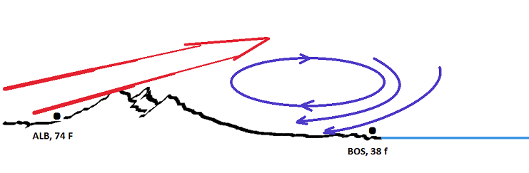
Ha, this sentiment suggests you know this region all-to-well. It's likely to happen ...but nailing the arrival timing is tricky. The total synopsis reveals today's balm is quite precarious. The models are building surface pressure in rapidity throughout Quebec during the day-light hours today. The surface pressure contouring in fact orients Brian and points north as though they are already behind the boundary, when no boundary hasn't actually gone through them - the mass field just rotates ... But this sets up the classic mass discontinuity, where NYC is lower in pressure than PWM and down the boundary rolls. The NAM has been hitting that timing arrival ~ 4pm for Rt 2 and the N. Shore Eastern New England's physical geography causes these pressure discontinuities to move SW. Because the elevation of NE PA to the Greens/White, produce a natural topographic barrier, and this causes an "implied" rolling motion to the the winds as that warm sector's wind motion you see here ( PA and southwest of there...), moves over then you get the eddy curl... It's similar to why there is east wind sometimes in the Plains ahead of a S/W nosing in from over the Rocky Mountains...only it does it at a smaller scale. Anyway, because we are right next door to cold Quebec and Canadian Maritime waters...those then mesh in dense chilly air. So you have constructive interference that really favors least excuse imagined to decouple the lower atmosphere from the mid levels. Think of it as opening a freezer door, and watching the steam roll across the floor. It's 10 F in the thin layer at the bottom? Well it's 38 in Boston and 72 in NYC. ...The fact that it seems to always happen during the Red Sox home opener series is a separate and arguable supernatural phenomenon, altogether.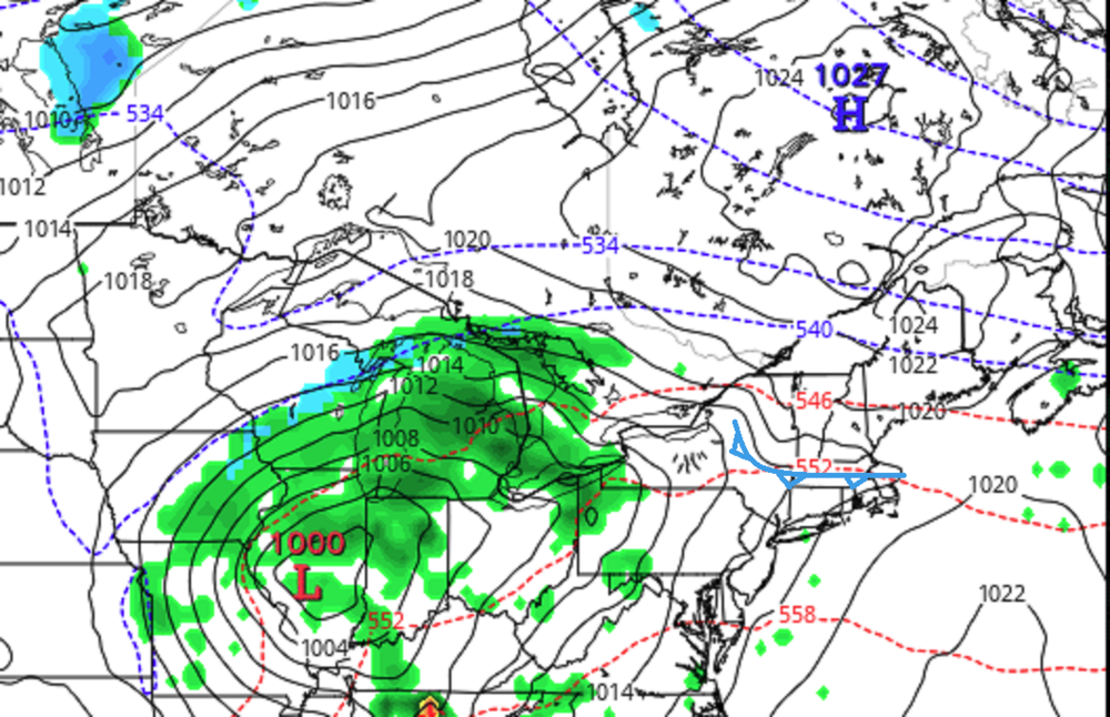
-
Seriously? what the f is wrong with what I wrote about Mish, that set this shit into motion... man
-
March 2022 Obs/Disc: In Like a Lamb, Out Like a Butterfly
Typhoon Tip replied to 40/70 Benchmark's topic in New England
Mixed indicators … in one possible reality Will and Scott’s colder profile and possible event is actually in some models. in the other, CPC’s powerful MJO/La Niña climate warm washes everything by the last week of the month - emerging in the models given time. either scenario gives room for cold next week. You may want to clear your calendar for at least that much. By then we’ll have a handle on whether deep spring really arrives the last week. It may be that we conjure up an exit event type deal 24/25th -
Oh I’m just a cave man and your fancy typing machines frighten me … … now get me another Dewers and water