

Typhoon Tip
-
Posts
44,231 -
Joined
-
Last visited
Content Type
Profiles
Blogs
Forums
American Weather
Media Demo
Store
Gallery
Everything posted by Typhoon Tip
-
no shit...? hey folks not-so-cool aside/trivia, London's Luton AP suspended flights because the high heat has apparently damaged the tarmacs. We're supposed to top 90 here tomorrow, and then add 5 for Wednesday ... possibly lingering into Thursday to register our first pan-wide heat wave. There's a little known telecon that correlates western Europe with eastern N/A ... which seems to bear out this week. Interesting.
-
Re the flood threat... meh, I spoke about it yesterday but one of my assumptions isn't panning out too well. Cell movement velocities ... too fast. Yes, where these 50 DBZ strafe over the air'll turn blue-gray choking water board intensity but these this activities is haulin' ass.
-
Day dreams ftw - Nice TCU build up over NW NJ in that 'seam' where the denser overcast opened up like we envisioned. That's probably going to cut loose in there. That'll then propagate down stream this afternoon as heavy rain - I suspect. It's 78/72 here with pittering rain and urine puddles ... gross. The sky has that day-glo brightness to it, so it's allow some modest insolation to the ground.
-
Under the radar kind of oddity to this day... as it then moves into Tuesday thru Thurs... Firstly, we have the first pan-dimensional heat wave likely occurring spanning these next three days - we haven't focused on that earth shattering tear-shedding inspirational natural specter (I know... heh). But yeah. One day of which may be 'big heat' threshold. Not bad for an overall +PNAP flow structure across the continent... But ... the under the rad-ism is, how often do we have any semblance of a severe threat, however presently fleeting that appears to be..., and then go INTO a heat wave from that circumstance, around our region of the country? That's rare for us. We get our severe by heat obliteration events - or almost always have. It really woulda been cool to see someone get the severe and then sore to 92/72 tomorrow. That'd be some mock-Dallas antics there...
-
Yeah ... I posted too long of a read an hour or so ago - I tend to agree with asking the question. I "think" what may happen just looking at the sat and then day-dreaming ... there may be some eruption of activity over N-PA over to SE NY later this afternoon, as there is an axis of thinning sky cast creeping up to that region associated with diffused warm boundary passage. "If" so...that activity would then smear ENE across the area as decaying rains ... but falling through a PWAT anomaly that may help rain rates.. But as far as severe... heh. I don't think this has the mechanical/synoptic forcing necessary to do much without CAPE - also a hypothesis being tested
-
NAM numbers... 12z Hottest day of the year falls on climatology - that's a bad luck omen for winter! (No, I'm kidding - but that outta get the panicky winter-event codependents sniffing their armpits for comfort...) But these 12z numbers for Wednesday July 20 are impressive! 850 mb temperatures over LGA to Logan are +19 .. +20C. The T1 at Logan at 18z is 32C at roughly 300 feet( 980 mb). The slope temp probably LIM--> around 34C (93 F) This could have been 34 --> 36C for nastier high of 96F (rounding notwithstanding), but ...the 700 mb RH values are between 65 and 72%, which by convention assumes partly cloudy. I suspect that is the limiting factor. The 12z Wednesday morning hydrostats are roughly 574 dm in the area, but they surge to 578 ( almost 580!!) by 00z. That means that the model is calculating heat input into the system, particularly because there isn't appreciable +d(dp). So the expansion of the thickness came most likely from diurnal heating. Take increase(decrease) cloud coverage and the temp probably adjusts - which is intuitive anyway..ha. Anyway, these numbers in the region suggest 95, which is the 'unofficial' big heat threshold. But,... the real impact of which ...the DPs in the area are 70+ ...so we'll likely need headlines in the area posted if these NAM numbers get more ..support/confident. I should note, the 00z Euro was also 94-96F across all of interior eastern Mass ...down to NJ.. so, yeah...it's not alone on Wednesday's climo crowing.
-
This more than less echoes what Ryan and I were mentioning yesterday... ...Northeastern CONUS... Scattered thunderstorms should form from midday through early afternoon over western/northern parts of the outlook area and spread eastward/northeastward, offering scattered damaging winds, with at least a few 50+ kt/severe gusts possible. A few tornadoes also may occur, especially over northern parts of the outlook area in the eastern NY/western New England region. A seasonally strong superposition of rich low-level moisture with increasing large-scale ascent and favorable deep shear (ahead of the ejecting northern trough segment aloft) will support convective organization across the region. At the time, I was thinking more short duration huge rain rates.. but, yeah.. I'm not liking satellite trends though... I was thinking there was some chance we'd end up even 15 or so % less ceiling and allowing insolation through, but the recent/morning trends are slammed shut. Not sure this system has enough of those mechanics to do much other than heavy rain, without more instability/sfc to mid lvl lapsing. The activity along the S coast appears associated with diffused warm boundary... and there is a climo precedence for morning w-frontal smudge, then lull, then ? Day's are long... the southern edge of the miasma is thinning N ( perhaps more so then moving N) over N NJ ...Long Island, so we could end up with dim sun marginal help mid afternoon just by 'gunkology' Not to discredit the efforts of the forecaster.. but he's on to mentioning, "..outflow/differential-heating boundaries..", whereas for now, the d(insolation) is pretty close to 0 from ALB to TAN across the area.
-
UK Met Office Forecasts 40C for the First Time
Typhoon Tip replied to donsutherland1's topic in Climate Change
There's been minor fluctuations in the modeling over the last several days as it pertains to this event, but by and large ...a robust continuity, nonetheless. That lends to confidence for a couple top rank hot days. Last Thursday .. the ECMWF was perhaps .5C hotter 'edging' this event. Over the weekend ..typical model noise may have 'dulled' slightly slightly... It's still within error acceptability - the UK office put out 38C for the highest at some point during ... when the previous (Thur last week) was 40C aoa the 80th percentile confidence etc... Model noise. What's interesting is that the GFS model is actually the hotter of the two guidance. If that 2-m were to verify, this whole discussion is moot. Everyone breaks records south of ~ the 53 parallel over the vaster area of the E and S of Isles. Yet, while London and the B. Isles region in general are capturing story headlines ( probably due to association oddity/psychology), the real 'danger' is in N. France. Those poor f's. Talkin' 42C (108F when rounding..) over multiple points in the graphical hover/pt&click. Not to over-sell that. The heat event in the Pacific NW resulted similar or even > results... I don't know what their records are in the N of France.... but that's also along the 48th to 50th where that event took place in the Pac NW, fwiw -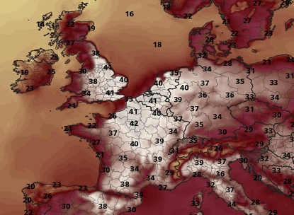
-
It does look like it’s trying to bias W-N yeah Tues/Tues night are getting uniquely brutal looking in the NAM’s very recent numbers. Like 91/75 prior to full mixing midday Tues … possibly to 93/68 … 78 out at Logan at 5 am for the low and likely 81 much of Tues night.
-
UK Met Office Forecasts 40C for the First Time
Typhoon Tip replied to donsutherland1's topic in Climate Change
I'm surprised it hasn't happen sooner with the blocky summer ... But then again, the AO has been positive, despite the tendency for blocking nodes in the Ferrel latitudes. Been a bizarre split hemisphere like that.. .with concurrent diametric mass fields - and it's hard to argue stability in maintaining that when it's been going on for 6 weeks. interesting -
UK Met Office Forecasts 40C for the First Time
Typhoon Tip replied to donsutherland1's topic in Climate Change
Yeah...it appears as the mid range came into this nearer/short term the heat's eased some. As far as records.. 38.7C vs 38C can come down to waft perturbations near the thermometer housing. Probably not 40.. I don't follow the dailies with model performance over western Europe... My experience with doing so over the N/A continent is that all models tend to have an amplitude bias in the late mid range that corrects toward less crossing over the D4 .. 5 range. I'm sure they have godly experienced forecasters in the UK Met office doing analysis - they know. But I wonder what nicked this since Thursday when the news broke that it looked historic at first. It may still be ...not saying it won't. 38 is certainly notable even if it falls short. But 104 over the cobblestone streets of London would've been amazing. -
I got bunned above for daring others.. .heh. yeah, like the shear profiles and the low LCL thing/overlay
-
This 'was' the heat wave toward the end of the month...
-
I'll have to find it.. but I recently read a summarized paper that gave the watered -down version (n'yuk n'yuk) of a why there is a "bounce" mechanism in the arctic wrt to sea ice, that is caused by accelerating periods of ice out. The arctic is warming faster in CC as of last check, than any other planetary domain space. Concomitant with that ...we've seen dramatic recession in integrated ice so far this century. Clearly ... that should represent an "accelarated" geologic period. I wonder whether any currently observed "slowing" and/or modest date-relative gains, may be related to those studies' causalities. It also seems intuitive given all the complexity in the moving parts of the total planetary system, that deltas would tend to be polynomial - there would likely be irregularities ('serrate') along numerical curves.
-
Same down here... Crisipies with some elevated opaque regions hanging beneath alto-strata height anvils. No glaciation ... yet looks like some must be taking place in that cell.
-
FIT's hygrometer needs calibration ...or at minimum a check. Today is a good righteous reason to check that station.. There is no wind appreciable enough to argue mixing idiosyncrasies/ and geography, yet EEN, ASH to BED... ORH ...pretty much everyone in the triangulum that surrounds FIT has a DP of 64, while FIT is 57. I am located 10 miles as the ruler line goes from that station site, and all home stations are 68 to 72 ... and it feels more sultry than 57 by a goodly margin. Now even owing to the local garden/rural effect and accounting for that, FIT seems to me to be a modest to at time egregious negative outlier.
-
UK Met Office Forecasts 40C for the First Time
Typhoon Tip replied to donsutherland1's topic in Climate Change
This may have already been accessed by the forum users .. .but, it pertains to the June period ( recent ) in general, which I find to be too plausibly link-able to the whole aspect re attribution and/how it pertains to what is happening now. https://www.metoffice.gov.uk/binaries/content/assets/metofficegovuk/pdf/research/climate-science/attribution/western_europe_attribution_june_2022.pdf It's probably becoming entirely academic that these "rogue heatwaves" are attributable... As an aside ... I have found there to be an increasing frequency in "teleconnector correlation" failures, both air to air and air-oceanic ( the latter of which are more related to seasonal forcing). This has been been evidenced in recent winters where/whence ENSO biases have shown increasing tendencies to decouple from the circulation modes. There is a little known western Europe/eastern N/A positive correlation, when inference uses the "previous climate" That correlation argued June to have been hotter over the M/A and N/E regions than it was, if/when using the previous statistical model. It was not. Much of the region, albeit local if even possibly outlying compared to the total continental space ..was in fact modestly negative. I am not sure what the monthly means for UK vs the former, spanning the whole month of June. But there were not any heating events requiring any sort of attribution analysis over eastern N/A, either way. I believe the reason for this apparent increase in lower correlation observations, is due to CC forcing circulation structural changes. It's been observable/suspicious for over a decade for me personally .. but, these evidences keep emerging. There are other more empirically measured values that are likely related .. Such as, record breaking commercial air liner air-land-speed records being set across the Pac and Atl flight routes, W-->E occurring with increased frequency in the same time span. The appearance of unusually steep hemispheric gradients during cold season, with unusually strong/progressive pattern biases ... These are related to disrupting R-wave distribution/footprints as a plausible conclusion - The above serving as a hypothetic premise, "I" think it is worth it to paper that. It is time the scientific community takes this CC --> 'synoptic base-line' forcing more seriously, because these statistical derived means were all created during a time of relative climate stability - prior to 2000. Where as since ... the 'hockey-stick' climate changing should immediately conjure ( intuitive objectivity ) skepticism of ENSO to seasons, as much as shorter intra-seasonal correlation disruption among the purer atmospheric domain-to-domain regions . -
12z NAM likes the idea a little better ... An important factor's going to come down to how much we can add to CAPE via insolation. The T1 at Logan is 23C at 18z tomorrow... That's a bump over previous runs...and suggests there's some correction potential to warm more. It's looking real real gunky though... Even without that, where activity still manages to ignite I suspect the rain rates proliferate tomorrow afternoon and evening. About the only aspect I use the NAM for ( ...other than gawking at winter QPF numbers when it's yankin' people's chains with it's NW coastal storm bias...) is convection initial conditioning. It's always had a sneaking decent job in that one area.
-
Meh... clouds look hopelessly slammed shut from 15z onward ...but still, with DPs 73-ish and deep in the bottom of the sounding ( something we haven't seen much of this season btw -), it's still interesting with those modest hgt falls meandering over top in the afternoon. Damn...just a little more sun.
-
I'm wondering if short duration/ small scale areal coverage FF warns for excessive rare-rates Monday afternoon and evening should be considered? Low amplitude, but sufficiently lowering heights aloft evolving over the top of guidance blended 67 to 74 DP ...along and S of a RUT-PWM ...west to east through New England. May even be milk sun/modest heating in the morning. Looks like slow moving heavier results relative to DBZ. Any cores over 45 are likely to lower visibility to < 1/3 of mile with rapid ponding on roadways and/or low collecting points. Lesser considered factor ... erstwhile desiccated top soil types are actually primed for rapid run-off/responding low areas to 'fill' before absorption. I mean... these kind of events hit the evening news some how some times - may as well try to identify the framework ahead. Primary risk for that would be along White Plains NY to Concord NH with less SE and variable in the over-arcing mountainous terrain. I could see cells moving lower to moderate speed with rate rates exceeding rad returns given that ginormous PWAT air. More sfc heating than modeled? ...if a doable now cast, things might be interesting.
-
Thursday looks about as close to ideal synoptic parametrics for supercell propagation through New England that I can recall observing in guidance. The Higher res Euro even has a right turning cluster of dense QPF nodes moving S of the environmental steering, from S VT to NW RI... GFS has the synoptic layout, but lacks the discrete resolution ..otherwise, they're identical. Not likely to survive the next 84 hours modeling perturbation but that's a helluva set up - for now.
-
I dunno... I'd call that pretty hot for us actually. Two reasons: One, that area of Nebraska/Kansas and SD are already sitting at a minimum of 925 mb as their surface sigma, and probably closer to 900 or 875 in the western half. Those anomalies over us mean more for a projected sfc temperature because being 1000 mb down to sea level, east of the Berk's/Mts means the adiabats are extended farther. d(t)/dp is a shallower differential out there compared to here... I mean it'll be hotter than here, because moreover to all that, the lowest 25 mb will also slope harder to the right due to superior land/air radiative transfer space.. but when I see +4.5 over climo at 850 mb, for PHL-LGA-BOS-PWM ...which are near sea level, that's really a huge signal. If climate is 16 to 13, were talking 21 to 18 which is 90+ from an ensemble mean in an aggregate spanning 30 days... that's actually pretty massive. Two, that being a mean ... also means that a few members are probably bizonker hot. The other aspect to the average is that it provides a general arena of enhanced probability for local time scaled extremes that lurch above(below) the longer term mean. Conclusion: You probably don't want to see that above if you are a temperate loving, heat hating sort. Which means it'll be too warm - most likely ... - if anything.
-
You know ... last year, prior to the Pac NW bread baker event, I'm pretty sure the models began signaling absurdities, too. Just sayn' These models ( you know this but for the average reader ) don't prog physically impossible solutions. They may prog solutions harder to realize for other 'emergent' offsetting factors that are not really predetermine-able.. .but, something peculiar is going on out there because that 5-7d aspect you mention, where the physics and inputs they are working with are flagging that we're 'playing with fire' - you gotta wonder if we're counting on the unforeseeable emerging offset as protection. Meanwhile, SE of Wales is objectively forecast to breach 40C this week... so, the era of the "syntergistic heat waves" is clearly upon us ...not having to wait to 2040 for the climate models to be right about that... get me started -
-
Brian check out that 2 am temps in that area... Like a hundred degrees... oy

