Typhoon Tip
-
Posts
44,231 -
Joined
-
Last visited
Content Type
Profiles
Blogs
Forums
American Weather
Media Demo
Store
Gallery
Everything posted by Typhoon Tip
-
Severe Weather Threat Week...so many threats!!!
Typhoon Tip replied to weatherwiz's topic in New England
there's a snarky comic angle to this day... It's 87/73 here where I am - although a brief sprinkle just passed with one distant rumble so it may be 82 or something... anyway, it's 90/73 in Boston. 90/73 ... --> do we have enough ?? what's wrong with this picture? most sites were all at minimum mid 80s min/70+ DP, at some point late morning... Tell me we are not caught up in a warming world when T/TD combo like that have to negotiate a way to nuke the mid levels. -
Severe Weather Threat Week...so many threats!!!
Typhoon Tip replied to weatherwiz's topic in New England
hence the use of the term, '...anyway' as in, all things considered - we're not appreciably different than what transpired last week... But so far, last week outperformed this, by the way - least we had SC's straifing the region. We have better 0-3km mechanics... - yup. I give you that. We have a rapid pealing off the clearning that's probably going to mean more for Mass than CT, but yeah... That stuff is true. But last week there was a resulting convective wall down of LI just like now, and in both occurrence, ...there was sun robbing. It's comparable. It's not liked or wanted - but it is comparable. We'll see what the clearing does for us... It did also clear before too late last week, so even that bears resemblance. I'm also a little personally biased because my internal monologue has thought all weekend that today looked similar to last week, and then here we are with these next of kin observations bearing similarities... so tfwiw - -
Severe Weather Threat Week...so many threats!!!
Typhoon Tip replied to weatherwiz's topic in New England
This is reminding me of last week anyway... Right down the convective wall lining up down the N shores of L.I. ...robbing everywhere N of there sun by way of farting their anvils down wind in a hyper velocity mid level flow that can only be explained by CC ... f us -
Yeah..I'm sure it was modeled - no problem there. Good job models ..I guess. It's still unusual - I can see in that product how that was drying issue sort of east of the Berks and Whites. hmm. I just wonder if we have local antecedent conditioning lending to some of that. Thing is, dps always go down during diurnal heating/mixing but the amount is what interests me. heh...whichever 98/62 was never in contention in my mind.
-
I agree with Brian that in the stricter fairness, 63 DP is taking the "edge" off what could be extraordinary ... But, my personal experience in dealing with yesterday and the day before was that it wasn't much of a reach-around relief, either. I'm certainly glad the DP mixed out/down to the low 60s both days - but both conditions can be true. It can be both not as bad as it could have been, but also , ...really f'ing bad man! Having said all that... I'm just curious if there's some bit of "desiccation feedback" ... I've read before that antecedent arid soil conditioning can absorb DP right out of the air... We may be refitting DPs/theta-e in shallow decoupled layers because the rates go negative briefly overnight, but when the sun hammers the landscape and heats the surfaces ... (maybe - I'm just suggesting/wondering here), together with expansion thermodynamics it's eating out the water in both directions. I feel pretty confident that 74 DP going to 58 to 63 is a little on the unusual side.
-
Severe Weather Threat Week...so many threats!!!
Typhoon Tip replied to weatherwiz's topic in New England
Nah... once per diem during transitioning fronts is the NE allotment ... you're all done. -
Severe Weather Threat Week...so many threats!!!
Typhoon Tip replied to weatherwiz's topic in New England
heh I dunno - This looks like an EF4 1::1000 year tornado outbreak event in the absence of this dumpster overcast, in which case, it is a very common local climate case scenario of epic waste of a 1::1000 year event ... . -
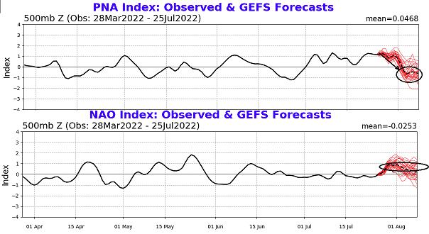
You know... there really is massive heat signal emerging out of the blurry range of the summer teleconnector spread, for early August. The PNA's correlative significance is considerably less useful in summer compared to winter climatology. That is probably even more so true during CC, suppositionally based upon recent decadal experience, alone - but there's also turn of phrase around the papering realms. However, there are some circumstances where/whence the prognostic numbers may bear more signficance... and it comes from combining disparate sources whereby quasi -suggestion via constructively interference. The PNA is ominously signalling a huge phase change, which alone ...may not be as useful, but the NAO is also indicating a very large change - it's basically teleconnector convergence that points toward central to eastern N/A positive geopotentia anomalies. I find it interesting that we've been bleeding signficant 850 mb thermal anomalies up to ORD-BOS latitudes, when erstwhile this summer season...these above indicator were never very much in favor of doing so. So what happens when/"IF" this spread validates a real forcing ?? Note, looking backward along these histories below, the last time the PNA fell for 10 days while the NAO was rising(risen), was during the ridge eruption over the OV back in May. The only issue then is that there was sans a western heat/mass release into the circulation. ...so moving parts notwithstanding. Other more intangible aspects lend to the idea but tl;dr factor is growing here.
-
This is a solid observation ... It's been triggering me to ask if that amount of D(DP) across the diurnals, has been anomalous? I'm not sure if that's a metric that's really kept track of. We all know, Mets to enthusiasts, that we're shedding DP numbers usually nearing the highest mixing point/BL expansion. Normally per my farmer-John's-Meteorological anecdotal experience, that's in the neighborhood of 5-7 F... It's like you come out of the gates on a hot one souring to 86/74 and that's kind of your highest HI of the day around bout 10:34 am ( heh..).. Then, at 1:48, it's 94/68...kind of stationary HI more or less. 96/66 is the ping max. But lately I've also been seeing 82/74 at 8am go to 97/57s - I'm not sure if that entirely normal - like we're exceeding the typical delta(DP).
-
All I know - personally - is that I just spent two days having to be all over eastern interior Mass for lingering DITF stuff of my own/ceremonial shit, and both days were above 95 ..in fact, closer to 100, and it was an evolutionary hot experience... As in, physiological survival mode triggered balls down by the knees protecting sperm count miserable out there. There was a ceremonial thing at Wingaersheek Beach with 99 F land breeze pushing surface waters to England so that the 'soothing' up welled Labradorian glacial piss made the water ankle aching cold. You basically are f'ed for anything fun in that setting... But it wasn't really that bad ...no, because the DP was 64 - really ?
-
Seeing as we can and have in many instances in that past, registered 93/65+ combinations of ambient temperature, ... mid 90s/65 smacks like a "both conditions/arguments are true" sort of wash. Just calculate the HI for either circumstance... then delta the results. If it is within a degree in either direction, both are true and the whole discussion is mute when taking a subjectively fair approach based upon objective understanding of limitations, and local studies variance/outliers. But ...I guess that wouldn't satisfy the need for petty vitriol so - yeah...we'd suffer some loss there
-
To me ( ...seein' as anyone at all asked and gives a shit about mo ) EWR is sort of the equivalent lunacy of using Logan for the 'pedestrian' temperature, but going in the other direction - so to speak. The circumstance at Logan, for those privy to geography and local climate ... is almost entirely irrelevant to the Boston Commons ...certainly by the time we're out by the Cambridge side of the city - more over, those around the immediate metro-west, ...Waltham, Newton.. Milford ..etc... will use Logan's reading to point check their temp (as lay-persons that even though were born and raised and home dwelling over eastern SNE ...they have no clue how/why we're even having this discussion). They just think weather forecasting is a joke, ...not knowing that the discrepancies are because 'the humanity of operational Meteorology' acts like it is possible to uncover the Quantum Mechanical secrets that construct the very f'n cosmos that creates all of reality... but look out! Having a real representative temperature location/ sourcing is a sought solution that God him/her self just concedes can't be done... Contrasting, EWR sets out Totally realistically amid an Industrial arena so choked with NOX by air, footed under by enough heat retaining and re-radiating materials that pizzeria owners in that region could cook their fairs by way of heat-exchangers if they had the tech in place, ... using that location is tantamount to sticking a thermometer up the asshole of society's body to test the convention center prior to the function. They may figure out that ...some work in the vicinity of that station site bumped the device so that it points directly at one of those anuses, the jet wash out of the run-way B out EWR ...I don't know, and fix it.. but what's that going to do, It's going to lower the temp to just bullshit.
-
If this distancing historic anomaly ever happens it would present a distinguishing unique problem

-
BOS 99
-
Agree with dewpoint… It’ll add today. Both Fitchburg and Boston Logan nicked 90 prior to 930 this morning. it seems big heat is a slam dunk but how much? Kind of a narrow allowance ceiling scenario with all that convective junk contaminating skies not so far away upstream… In fact we’ve had periodic high-level miasma fanning out from that Michigan strobing overnight, overnight overnight and into this morning, and when you’re dealing with higher end heat any little perturbation in insulation takes off whole degrees.
-
Fwiw- I was over there in Kittery Maine during yesterday afternoon and evening and the air smelled pleasantly like the ocean and the temperature was 86 by the time I got onto Route 1?passing the Trading Post. And then further down Haley Road it was actually only 84 …but that road is also draped over pretty heavily by tree canopies – it’s only about 3 miles from the actual beaches at that point, too. But what makes it interesting is that just 10 minutes earlier along I 95 just before the tolls it was 98. In fact… The whole way up from around Westford mass to the 495 split off well up the way from Haverhill was between 99 and 100 but I figure that was just the highway heat tube effect. Most Davis or home stations within 2 miles of my house look like they maxed out around 97 yesterday. But it seems like there was weird decline spots like Fitchburg couldn’t get past 93 while other NWS sites like Bedford made it to 97 or 98
-
The other aspect about tomorrow and expectations for top tier heat is the DPs are <65 over the vast region... Not sure if the lows will stay elevated enough to stage the morning. We like 75 to 78 mins ...such that it's 85 by 9 ... etc... 10 after 10 and so on. We use up the insolation recovering from 65 and we'll end up 96 instead. Brrr
-
I just drove from Westford to Ayer and the dash temp read 94 to 96 the whole way and it f'n felt like that man - woof (interior NE Mass)
-
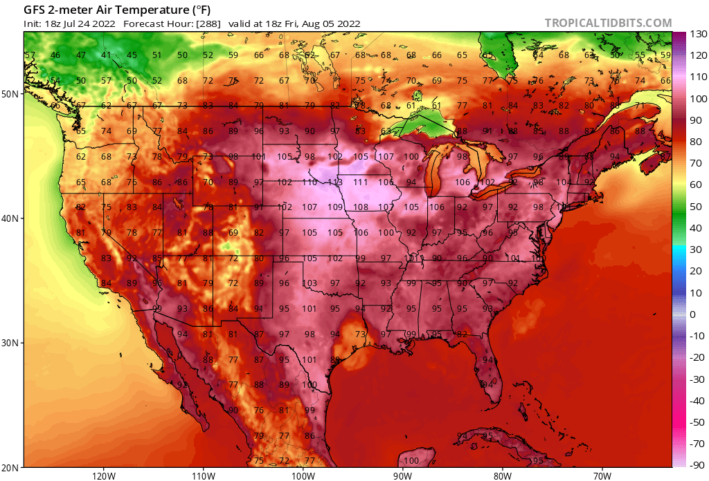
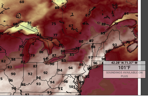
Fwiw - Pivotal's nifty floater still surfaces 101 across Boston's metrowest/interior SNE, per the 00z cycle. That's the 18z number, too - Pivotal doesn't do the 21 hour - The 06z cycle also went up a tick at what looks like maybe ASH(?) per Trop Tidbits, from 98 to 99
-
After having been a fan of the game for many years ...and also following the behavior of this team's personnel rotations vs success and failure over the last 20 years, that experience keeps telling me that this organization is not one that is top heavy in baseball actual intelligence. It has been one that has won in spite of that, as much as delusions of grandeur ( bit of snark there..) has kept times of loss dependably rationalized. This teams has had more lightning in a bottle seasons then any other in the Majors, spanning the last 15 years - I think they've been more lucky than many would face less accept. They may be an organization that is more top heavy with lots of money and a deep passion ( perhaps)e, together, but not really with acumen, inside the inner power core. It almost smacks like the happy go-lucky 'disconnected' elite wealth bubble that are completely reliant upon those they've appointed to 'tell them when aspects are going good or bad' They are not really 'in touch' ...until ... (and I'm imagining more so at this pint), it starts to hit them economically - which judging by the loyal fans and the sold out ball park, cheering on pathetic Red Sox runs, while the Blue Jays blithely and willing take a score more akin to an average football game for their side ... these wealthy owners may not be getting that message, because, as long as they're making money..? Also, perhaps that detached reality is synonymous with gullibility, too. Sort of easily lulled and manipulated by said rampart of appointed advisers, being baseball passionate billionaires that otherwise may not really know what they are doing. This organization needs to be blown up, badly, and said rampart isn't likely to advise the inner ownership of that necessity, because it means them too. Whether it is their fault or not, and sometimes failure just happens TO an organization, in spite of good intentions, too. But in either case, the solution is the same - unfortunately.
-
...and, one should expect with higher confidence, that barrier flow will cease to a new paradigm right around the 2nd week of November - any guesses on what that new paradigm will be/mean ? mm hm...
-
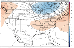
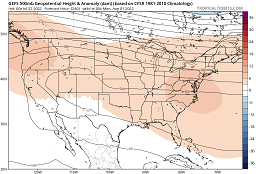
It's not convincing though... (for me). There's a WAR flex going on after a week in the ensemble guidance, but all modeling I've seen whether in singular depiction, or aggregate techniques, express it's expanding heights up the EC via accelerating mid level ambient wind flow. It makes that era prone to side swiping cool fronts despite the heights Typically, the WAR node expands and gains height, and then ..retrogrades toward the EC to eclipse and then continue expanding W ...etc. That's the typology. The models are doing the retrograde climo, but they are pinning the westerlies in position and thus squeezing the retrograde underneath. This enhances the westerlies wind velocity/ambient summer polar jet from lower Alberta to New England, instead. Thing is, you wouldn't think we would be looking at 95 on Saturday, and a possible 98 on Sunday, when looking at this circulation mode, So, there's no reason or necessary logic in presuming that this, won't also host blazing air masses... In fact, this particular 240 GEF's mean (500 mb anomaly) perfectly illustrates the WAR retrograding under a squeezed flow. So there are signs we could roast ..but that flow still could be reserving the right to sore-butt a forecaster's foresight. lol We seem to be observing some kind of planetary agglomeration of physical processes, the emergence of which creates this unrelenting super synoptic barrier jet ... pinned in place, that is a WNW flow across SE Canada. The WAR is present in this latter image above...but it's being ablated by that grinder
-
Severe Weather Threat Week...so many threats!!!
Typhoon Tip replied to weatherwiz's topic in New England
I can see the vil and crispie feeders from here. -
Severe Weather Threat Week...so many threats!!!
Typhoon Tip replied to weatherwiz's topic in New England
I'd watch out from MHT to CON -
Yeah..so Sunday looks like a hundo contender on this Euro cycle.