

Typhoon Tip
-
Posts
44,231 -
Joined
-
Last visited
Content Type
Profiles
Blogs
Forums
American Weather
Media Demo
Store
Gallery
Everything posted by Typhoon Tip
-
heh.. . the guy's an aging FB talent ...probably more utility at this point, but that is vastly better than the 'hole' they have at that corner of the diamond up to this point. It's a plug, but it might work. Let's get Devers back please? I feel like some of these moves are a psycho-babble clean-up effort in the club house - but that's purely speculation. It just doesn't seem like an accident that they looked so composed and focused last night against a 67-39 Houston, and won. All the sudden Nathan's like Kofax through 7 innings, and they have an effective bullpen 8th and 9th out of nowhere... Things can come together. All they need is a couple 7 game win streaks - not as tall an order as that sounds ... - then, just play 600 down the stretch. With this season's competition climate, they'll turn it into a relative success. Not saying they're winnin' the ALCS here.. but teams sometimes some how some way just get hot.
-
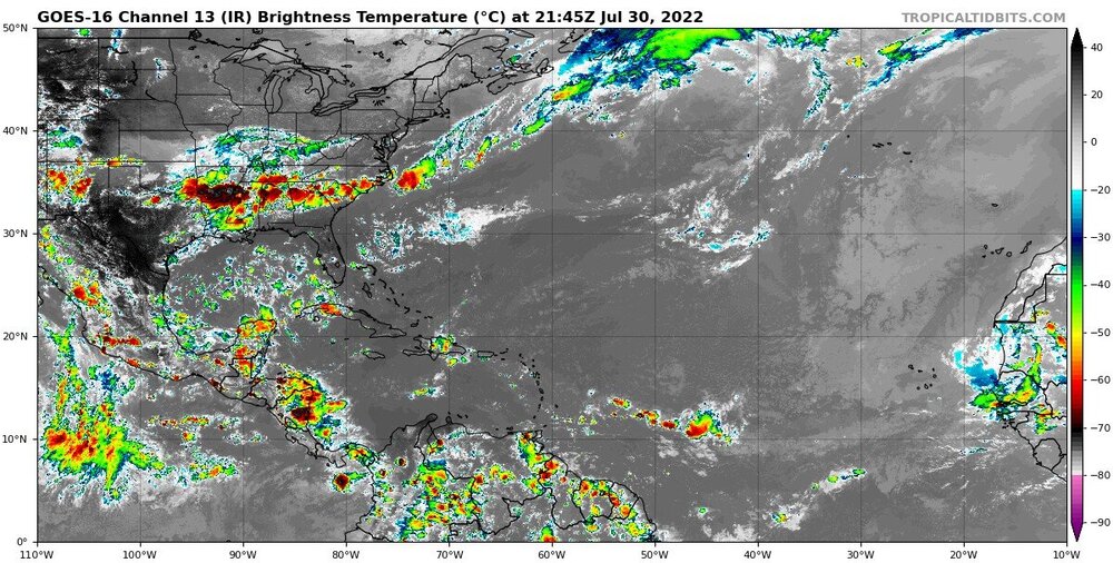
Fwiw • The MJO signal weakened through mid-July due to destructive interference with the La Niña base state. • Dynamical model RMM forecasts a continued weak MJO signal in the coming two weeks, and there is a lot of uncertainty regarding whether convective activity will continue to propagate eastward in the coming weeks. • The Atlantic basin continues to be quiet with regard to tropical cyclone (TC) development, while the East Pacific continues to be active, possibly due to Rossby wave activity enhancing convection.
-
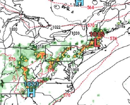
Not entirely sold... There are two possibilities for Friday - one produces local near headline rain results, the other is more scattered... That day could turn out ripely set up for repeater downpours after a morning temperature burst ...set up by the previous big heat Thursday. The day is unilaterally modeled to fester DPs to nearly 75, with high initial surface temperatures .. Sun will be important. IF so, there's a front paralleling the mid level stream lines ...pressing S and stalling in that on-going heat/DP morass. It could train CBs along fractal designated routes - who knows where that would be. The 2-m products are banging 97 between HFD and ASH axis, but I think that's over done... What are the convection temperatures? That's one school... The other school is that the front is over manifested in the guidance...so less S and the axis ends up farther N and weaker at that... As a separate sort of plague, we could still run into a neggie feedback due to antecedent dry summer 'sucking' the moisture back out of the column - we've seen something like this on a couple of occasions already...where 70 DPs at dawn vanished in waving trees blown through by arid hot wind. I think it was all the way down to 58 on hot Sunday July 24 when Logan was 100 as was metro west. This would have to correct pretty fast in the guidance though, as we are at D4 and they agree - it's probably time to expect a quasi -stationary boundary falling asleep through region by Friday afternoon.
-
GFS at 18z … good thing that’s beyond 300 hrs I guess - depending on one’s point if view. Overall this run caries a well above normal signal through the ides
-
Occasional Thoughts on Climate Change
Typhoon Tip replied to donsutherland1's topic in Climate Change
https://www.pnas.org/doi/10.1073/pnas.2108146119 Abstract Prudent risk management requires consideration of bad-to-worst-case scenarios. Yet, for climate change, such potential futures are poorly understood. Could anthropogenic climate change result in worldwide societal collapse or even eventual human extinction? At present, this is a dangerously under explored topic. Yet there are ample reasons to suspect that climate change could result in a global catastrophe. Analyzing the mechanisms for these extreme consequences could help galvanize action, improve resilience, and inform policy, including emergency responses. We outline current knowledge about the likelihood of extreme climate change, discuss why understanding bad-to-worst cases is vital, articulate reasons for concern about catastrophic outcomes, define key terms, and put forward a research agenda. The proposed agenda covers four main questions: 1) What is the potential for climate change to drive mass extinction events? 2) What are the mechanisms that could result in human mass mortality and morbidity? 3) What are human societies' vulnerabilities to climate-triggered risk cascades, such as from conflict, political instability, and systemic financial risk? 4) How can these multiple strands of evidence—together with other global dangers—be usefully synthesized into an “integrated catastrophe assessment”? It is time for the scientific community to grapple with the challenge of better understanding catastrophic climate change. -
Actually ... looking closer at the features Friday, it wouldn't shock me if NE Mass BDs... There is modest +PP working through Maine during the morning into/thru the afternoon, and then we have eruptions of outflowing convection in the ALB-Brian band down toward MHT by 18z. It's likely that together that cuts into the region - if all sets up that way.
-
has that light SSW breeze look... probably 78/76. Basically, the water temperatures between the mouth of Buzzard's Bay and Block Island.
-
Subtle but important differences in this Euro run signify a hotter look Friday and Saturday and Sunday... The front it's been hanging around with is ( awt ) minoring out and leaving the region open to the effects of WAR expansion west, and the ability for greater diurnal heating. Saturday morning has the frontalysis axis into upstate NY-CNE as a returning diffused warm boundary, and that look would be a miserable day from N NJ to SE NH... Probably heat headlnes in that look -
-
We have weird pancake cu in an atmosphere that's moving from the SW...
-
Stalled front... slow moving/light steering field aloft ... These cells are just overcoming the rising heights as the WAR ridge is retrograding W. The sun's zapping all that thete-e. Thing is...not sure how the Euro does at 114 hours with the particulars of convection/convective verification, but the orbital synopsis doesn't scream like this can't happen. That axis of convection would rain with impressive rates..
-
We could conceivably go some distance to correct seasonal hydro deficits between Friday and Saturday ...if fractals don't intervene negatively... Heh.. but that's a nasty look with that Euro's recent several cycles persistently stalling a front/frontalysis between along an ~ DAY-BOS axis. GFS is 70% or so similar but as usual, it doesn't prefer stalling features and keeps it moving SE into a 594 DM height wall which makes less sense... Pros are the immense theta-e pooling. I'm seeing the 00z Euro actually gets Friday back to 90F along the Pike, but DPs are nearing 75 at that time in the 2-m DP product as depicted over at Pivotal. Forget the HI talk for a moment, that's gotta boil up some big CAPE. If accessible, even an accidental pixel shower out of random CU would water board a down town crossing.. We don't need very obvious triggers in that environment, and the Euro is outright modeling a explosion of slow moving 3"/hr along said/implied convergence - even with the rising heights capping matters.
-
So it was already a hundred at Logan this summer... It occurred on July 24th ... heh, pretty much smack on the climatological acme. unless the number was since disqualified... I was around several locations between Clinton and Ayer that day ( Sunday), and the digital display on the dashboard was routinely 101 .. 102. Probably 96 ... 98 in reality. It's hard to trust a car's dashboard reading unless you turn off the road and drive across a grassy lea for several miles at a 20 bumpily miles per hour to clear the gauge of asphalt farts. or, maybe it was 100 at a few points along the way, just the same - hell, it's within the margin for error. So not just Boston's west wind anus out where Logan bathes in city wash.
-
As far as experiencing 100 on the skin - mixed emotions there. It's like how I want to go to Death Valley just once... Or stand out among the white sands above the Red Sea in a moment when it is 121/88. Take a few deep breaths. Gaze around at an ozone glazed sky that one's senses impels the imagination, its color hints as magenta. But, I would only do either if I had 100% assurance to escape avenues, immediately accessible.
-
I gave up on 100 three or so days ago in the ongoing speculation disco - Too many dodging idiosyncrasies starts to give that non-scientific sense that if you want to observe the novelty of ...anything really, be it cold or hot, rain or snow...wind whatever, there is a distinctly undeniable aspect where it deliberately does not happen ... LOL
-
Not sure if this is sarcasm but either way... I agree. It does this every year at this time - goes off the deep end and proffers skipping right over that pesky long slow grind of summer's end and its how about we jump right to Halloween - who's with me! The thing is, the climate starts to cool off after the first week of August anyway. So, the same way the model is overly amplified like 90% of anything it's physics is permitted to see beyond any given D7 ... it tries to do the same thing, but not with just events but the whole season once Augie roles around. It just annoys me that it can't do this the other way in April... when it holds on to winter and as soon as the D7 arrives, it looks like the chart may as well be Feb 15th. It goes along with it's over all wild cold stormy vibe it biases toward in the extended, in general.
-
It's possibly the lack of ITCZ that's causing the +anomaly SAL - or there is some governing factor relating to both. Looping this for the last 5 days, take a look at the African side of the MDR http://tropic.ssec.wisc.edu/real-time/sal/salmain.php?&prod=split&time= The SAL has zipped shut the region. There is no cloud production at all subtantive enough to condensate and clear out at least the ITCZ. It's like the equatorial monsoonal trough it's self is weak - or stopped. weird. Not only that... I'm also noticing there is a perceivable dearth in both frequency and intensity of TW demography. There are none...
-
I dunno..it's kind of hard to tell what's happening out there. It seems we're nearing seasonal zenith in the non-hydrostats in these models - perhaps in reality. It is difficult to parse out if there are any real heat bursts embedded.. Thursday looks legit. But beyond is very dubious to me. The Euro at 00z pulls off the largest c500 mb height anomaly spatial layout out perhaps in years by this Friday and Saturday, encompassing everywhere S of 50 N ? 71 F 18z Friday. Ok - Meanwhile, the GFS thinks it's late November with the power of polar jet it Neptune's across southern Canada...so much so that it ablates the heat's ability to get N without sanding it off by phantom fronts. It was wrong about the 5 day heat wave because of that reason, and that thing happened in less ridging so there's very little confidence the GFS isn't just typically SPV happy.
-
It’s interesting that as July turns the page into what is typically a very active month for tropical genesis, we peer out across the entire breadth of the Atlantic Basin and we can only define absolutely ….nothing… Zero aspects of interest.
-
PF and I were speculating this oddly disparate layout of temps today late last night. Slightly below to above Nw to Se in the same well mixed atmosphere is unusual
-
So y’all gonna be below average by a “few” degrees. Hmm. It’ll be interesting to test that idea. I mean 1 or 2 sure. Sounds a little NNE Met love me some cool bias talk. Lol But it’s likely to be 2-4 above normal down our way. It would be interesting if that spread happened.
-
Heh. Pretty sure if that 21z Euro max T happened it would be the hottest day ever in our local climate history. Even if one or two points in history matched, the regional integrated e-V would have no match so deep that ORH is the same as ASH… and it’s 98 at 1200’ Winchendon … that may be on par with the PAC NW’s SD But this is akin to drooling over a juggernaut on a D 9er chart in winter
-
That EPS 500 mb anomaly loop off the 12z looks pretty f’n ominous tho wow
-
Not that the NAM is much of any use to anyone but .. the T1 would support a 2 meter T of about 31C both tomorrow and Sunday over Metrowest of Boston. I mean, 88? brrr It may be very dry with low DPs and all, but like every outlook that has ever existed since about 1998, we end up having to eat the over crow come time.
-
FIT
-
Synergistic heat though ?


