

Typhoon Tip
-
Posts
44,231 -
Joined
-
Last visited
Content Type
Profiles
Blogs
Forums
American Weather
Media Demo
Store
Gallery
Everything posted by Typhoon Tip
-
Some interesting failures 'cooking' today - I think.. I mean verdict is still out. But Logan failed to maintain offshore forcing - they've been pipin' ESE all afternoon at 15 mph. They're in the upper 80s after making 90 by 9:15 am... That wind behavior was not really picked up ... Not sure if that's penetrating into the city limits. We are busting below MOS at FIT and BED and ASH. I mean it's fuggen hot out - don't get me wrong. But 93 is light. Uh...okay, BDL just bumped 95 ... we may see these squeeze up a 2 or 3 over the next two hours. In fact, these types of WNW dragon fart days tend to max at 5:10 or something. I wonder if the forcing kicks in out there at Logan and they bounce at 7 to 94 -
-
I'm on three consecutive seasons of snow fall deficits out my way. But, I guess in the grand scheme of things, you and I are probably in the same essential climate boning zone because it only takes a crow 20 minutes to fly between our sore butt empty snow holes. Hyperbole aside ... the idea that snow has increased at a seasonal tally I think belies things. The distribution of statistical occurrences - I suspect - may be more important in the discussion than the scalar seasonal mean. If we are going more 3 month periods of shits for snows... then, getting one 30" CC-PWAT enhance occurrence... another 45 days goes by and there are 3 spring blue bombs of 8-10" a pop, that will send the seasonal totals above normal ( or minimally to normal -), despite the winter being clearly plagued by fast jets and sheared shit and rain events and three 60+ F warm thaws that just did not happen years go - not nearly as frequently as they have been. This animation above is a rough and sloppy cinematic repro of the winter tones I personally have witness over the last 10 years. It's important though, because we miss either that 30, or the 3 lollypops in that gross example, and that's the deficit ball game. Realistically, that becomes more and more probability favored in warming CC Politics is perception... Pretty sure as a Sociologist you might have encountered this adage at some or the other...? just guessin. LOL. But, it matters in climate in particularly. The general bulk population only takes seriously what they see. Most of CC is insidiously buried more so by invisible metrics than it ever has/ or will be, by snow. People don't respond to urgency' when it is informatic in nature. A person responds very quickly to sensations that appeal to the 5 corporeal senses. That is just the primal engine... Then, mid way between that end of the response-spectrum expediency, ...are aspects surrounding threats that are negotiable ...such as job, economics ... the shifting tone of the GF that gives you the eerie sensation you may not be the only disco stick she's bouncin' around on (or wants to-). Then, somewhere way at the fake caring response mechanism end exists that stare gaped while trying to process a global warming freight train that is probably to incomprehensible to understand to begin with - certainly given by what the nimrod scientist's diplomacy skills of a sociopath with Autism - ...sorry wondering. I'm just saying, the distribution behavior I think is more telling. It works with the 'warming faster than anywhere else on the planet' bs too, to reconsider distribution. If CC is causing more SSE flow into the MA and NE regions off the western Atlantic g-string...yeah, the nights'll tend to balm out and "lie" about about the warming, when not many people are around to "feel" it.
-
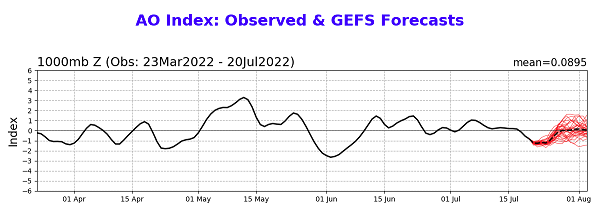
Pure conjecture... but, that may presage a more substantial melting interval of open ended length - tbd. If we look back along CPC's monitoring and prognostic AO curve, We see that since April 10 ( which is the 100 day since Jan 1st along the curve above, a time in which the monitored 2-m T first biased negative...), also began the time in which the Arctic Oscillation became positive as the dominating signal. There were some negative intervals along the last 3 months since that time... yes, but they were not 'long enough' and probably were more reflective of interludes of terminating warm advection to higher latitudes that were not representative of forcing the longer term mean. Which was positive in two distinct, longer intervals: May 1 to ~June 20..then again ~June 10 to very recently... Note, +AO is correlated to lower 2-m temperatures with the domain. From these observations and then considering the prognosis for modest negative index, the end of which is unclear as it only near neutral ( abv) by D10, and then seeing the 2-m turn warm, it is not a bad immediate notion that a warm flux may be about to occur. I also would note that ... 2019's big heat even in the NW of Europe preceded a big transport of usual warmth and an enhance melt event struck Greenland. So the idea of preceding warm terminating patterns into high latitudes sort of adds to this assertion. We don't see the present NAO progs as 'tanking' like they did prior to the 2019's heat delivery ...so this heat event may not be destined the same way, either. It'll be interesting to see what takes place over the next 3 weeks.
-
yeeah, all that. plus, Global Warming
-
Wiz .... do you seriously need to ask the question, 'why so hard to get an EML in here,' or are you just hand throwing - We are the farthest from the source. That is why. That was always why. That will always BE why - for ever. Until such time as a plate displacement event ... reorders the surface of the Earth such that SNE ends up where Chicago is, we will always get the leftover stench after a 2000 mile journey span of ill-reputing air masses ...
-
Have only seen the operational Euro and GGEM solutions from 00z ... GGEM is as usual between 1 and 3C cooler at 850 mb ...all regions, comparing to the Euro by the time Sunday rolls around in that guidance comparison. Not sure if that actually atones for a 'cool bias' per se - or if the Euro is warm bias but it is what it is as of 00z. I haven't seen the GFS yet ...because of it's remarkable ability to construct solutions that are insidiously antithetic to my personal analysis... No but as far as the Euro, it has 23 C at 850 mb, by Sunday evening, along a Newark NJ to Portlandia Maine axis. For the general audience, the adiabat from that sigma level runs down to 38C @ 1000mb ... as the gross read. That does not take into consideration the slope temp at the very bottom, where the 2-meter low income class spouse beater temperature roasts tolerances. Taking into consideration those 'realities' ... that 38C(101.4) would likely max 104.. or even '06, if unadulterated sun and idealized wind trajectories manifest at at LGA and BOS ... (hint, think about the civility that exists between those points). Heat's fragile as a guided metric... One cirrus plume poorly timed and it's a 97 instead.. Or if the wind is very light, so much thermal restoring force causing the winds to back SSE for 10 minutes and its game over. The last time we saw 850s of that Euro modeled genera, along with the fact that it also has <50% 700, 500, and 300 mb RH ( meaning, pure sun) was in 2011, when 103 was registered at Logan. Another aspect I am noticing in the Euro and GGEM and the GFS as of late .. .they are all tending to elevated the WAR heights. In fact, this Euro run beyond D3 really tries to have the heights hemispheric nodal geopotential 'dome' over Bermuda. Meanwhile, the flow super structure is some kind of N based quasi +PNA of modest construction. You have a hot pattern below 45N being compressed by an eastern Canadian cool circulation mode. The GGEM can't resist and suppresses all heat - which is unlikely. The Euro may be too excessive. Perhaps the GFS will be a compromise.. Off to go analyze it and it's ens mean to ferret out it's myriad of interesting ways it tries to mock me without being noticed... You know your life is fulfilled with worthy- riveting substantive value when you're being trolled by a f'n forecast model -
-
Might be kind of bunny to test the '9 by 9' then the later, the '10 after 10' rule of thumbs for making 100. Low probability for making that number, even though the 850s would support 99.7 ha. Looks like regional lows dropped more proficiently. All the way down to 68 at BED was not expected.. For heat enthusiastic trophy foisting, that's not an elevated enough launching temp for contention - usually. They have since quickly returned to 84 from that temp by 8:35 ...which is solid early performance comeback. BOS was 77, which is better. They've bounced to 86 by 8:35 already...so they got a shot at the 9 by 9 there. It's also really our first insert into W ejected air ...and the night clearly did not have this air mass under the decoupling - so that may cause for greater diurnals/surging. Those rule of thumbs are not limitations... Anyway, machine numbers from MEX and MAV are 97'ie as race winners, so it's long odds for KBDL/KFIT/KASH/KBED wearing hunderwear
-
OKC Graphical Links 22:05 Max Since 0:00 (GMT) Min Since 0:00 (GMT) 24 Hour Maximum 24 Hour Minimum 2.0m Temperature 107.6° F 109.9 at 21:52 71.1 at 11:52 109.9 at 21:52 71.1 at 11:52 2.0m Dew Point 55.4° F 64.9 at 15:52 53.6 at 21:15 64.9 at 15:52 53.6 at 21:15 2.0m Wet bulb temperature 72.2° F 75.1 at 17:52 62.3 at 11:30 75.1 at 17:52 62.3 at 11:30 2.0m Relative Humidity 18% 66 at 11:52 16 at 21:05 66 at 11:52 16 at 21:05 10.0m Wind Speed 9.2 mph 13.8 at 21:10 0.0 at 19:25 13.8 at 21:10 0.0 at 19:25 10.0m Wind Direction S - - - - Pressure 28.39 in 28.51 at 5:15 28.39 at 22:05 28.51 at 5:15 28.39 at 22:05 Altimeter 29.75 in 29.88 at 5:15 29.75 at 22:05 29.88 at 5:15 29.75 at 22:05 Weather conditions Mostly Clear - - - - Visibility 10.00 miles 10.00 at 22:05 3.50 at 12:30 10.00 at 22:05 3.50 at 12:30
-
Hm.. kind of agree with Steve though. So long as the wind's blowin around a bit, it's taken the edge off. I mean it's hot here. 91 or 92 most NWS sites and home stations etc... over DP the same as the page number of this thread. HI's are 94-ish with that combo. So we're getting it done - Tonight could be fun in the urban triple deckers where too poor to own A.C. units. Hobbyists should get their police scanners all tuned in and ready to go for that. T1 on the NAM grid was was 25C at 12z ...so it likely was 80 at Logan through 2am so who knows what it is over the living room couch of urban blight.
-
Is it as accurate as Wunderground lol... j/k
-
It does ... probably more than merely "seems" at that. We're the exit point after a fairly vast continental expanse that is transporting a mash up of every industrial, biological and geological fart lane since the Pacific coast. An amalgam that by virtue of that journey has mixed and mutilated and pretty much destroyed any 'spike' of anomaly-ability by the time it's wafting through. One thing we hold dear and unique to us, is that we have the greatest snow fall rates/ and actual density, within 500 ft of sea level, than any other region below the 55th latitude. ...I don't include LEK meso bands. But every region has their talent. 'cept, one of these f'n times... we will get a 26C SW release dragon shot - it's happened, albeit rarely... but our return rate on that sort of thing can be half a lifetime. My curiosity: what would 'hot Saturday' Aug 1975 look like now.
-
I was just trying to check things out ...I don't know what to make of this mess. Looks like a weak neg anomaly 400 naut mi SE of Cape Cod where the g-string passes through, yet... up there midriff across the basin the stream latitudes are modestly positive. Probably just environmental noise... But what does leap out is the appearance/suggestion of weakening of the Labradorian circuitry along the New England coastal waters, and in particular, around the horn of the lower Maritime
-
It's an interesting run for a few reasons.. at 275 hours, take note of the general synoptic evolution there -wild! 594+ dm hgts pressed against L.I., while a -2SD trough core tunnels through mid province Ontario latitudes. That's nuts... there's oddities if people know to look. It's like we'd need an EOF9 long tracked landphoon from Dayton OH to western NS to atone for that ... How many times does anyone see balanced geostrophic mid level (500 mb) wind velocities at 75Kts along the 588 dm isohypses... See? These are strange aspects that signify a troubled planetary system. Sorry to sound bunnish but jesus christ. But yeah...overall, this was a hot run fore GFS standards, a model that really has a learning disability when it comes to admittance of heights to higher latitudes. ..partially kidding, but it has been the most resistant. The thing is...another under the radar aspect about everything is that we are running above normal since July 1 at most climate sites, yet this is day 1 of the 'above normal' pattern. So like ...what's the difference? Clearly there's some kind of a pattern interpretation vs result disconnect.
-
Not progged to ... but, who knows The event that happen back in 2019 ... we could see the NAO bounce negative in the index forecast. Much shallower by comparison now, we see a small nadir but it's less than .5 SD. Back in 2019, the heat "dome" meandered to the N Sea then retrograde west at high latitudes... This thing appears to decay/smear toward the N. Urals .
-
...no, it's fair questions - I think the best way to answer some of that "relative extreme" is to compare it against local climatology - utilizing the Standard Deviation relative to that regions climate scope? That'd be my approach. Relative to Pac NW, their event may be of greater SD than what's going on presently over the B. Isles. It may not...I don't honestly have a scalar clue lol. But that's why we use math tools... blah blah. Intuitively, it seems that it is situation that has to consider the continental/geo-morphological circumstance of each region. Those limitations(advantages) may mean the Pac NW and the 40.2 at Hethrow may take place along similar return rates, but the SD would be greater in the Pac NW... I mean, they have down sloping.. .also, they are closer to a bake source of plasma in that the GB and surrounding cook regions of the west don't have to traverse the Med Sea... lot of conditions to consider.
-
40.2C = 104.36 ...just sayn'
-
Folks may roll eyes ( for some reason..) but it is still quite analogous to the SW/W heat release phenomenon that takes place across the N/A mid latitudes. Only in the western Europe paradigm ...rotate the dial 90 degrees. This is/was, as their "big heat" tends to materialize, a N. African heat release. It was pulled through eastern Iberian Pen region/over the western Med Sea, and given to the anomalous split -flow jet configuration ( the N branch of which is buckled around a NW European ridge), it got pulled into that circulation manifold and ...well, bake human bread time. Longer op ed: The issue with this event (...other than the notoriety of this being an all-time historic measure ...) is that this type of heat release/delivery mechanism is a phenomenon that has markedly increased in frequency since 2000 - the UK Met office in/with association to science/research attribution studies have been predicting the 40C benchmark for 2050 - but ...those studies pertained to regularity. Imho, having this one occurrence, however, is telling when grouping it in with the other NW Europe heat assault aggregate since 2000 - again, a rising number of them. It is telling because across the board of all climate prediction metrics, the occurrences of x-y-z extremes are taking place sooner than even recent more advanced climate models have been predicting. So perhaps the operative word is not 'telling,' rather, 'foretelling' ...Like, yeah... just maybe we won't have to wait until 2050 for 'regularity', not just in those stratospheric UK events, but elsewhere on the planet. Humanity won't have wait so long to prove they are a short-sighted asshole species that tragically ...has the intellectual brain trust to see the future being the douchy irony ( I'm in a bad mood... ) For all the fractured beliefs and denials about climate change to finally topple assumptions - usually... that can't happen without duress ... The conversation veers at that point hard into climate-sociological anthropology ( and is a fascinating field, where paleo studies show past climate stressing was a huge player in forcing every aspect of human evolution, from physical nature of race to the diversity of cultures) ... tl;dr. But in the future realm, changes are coming to existential reality because the environment it depends upon is inexorably dire - that means, it will have no choice whether people believe in the science warning them or not... And it won't likey all happen without wars, famine ... standard of living set backs ... Unless some form of Star Trekian tech utopian suddenly arrives off a well-time historic series of breakthroughs ... humanity is still just in a race that is entirely curbed by our responses to the system feed-backs. We are not making the rules of the game just yet.. .we are not Kardashev -worthy. Simple metaphors sometimes are best to clarify when in the weeds, ... but, we are a curiously clever monkey that just found a fully loaded AR-15 with it's safety disengaged.
-
Severe Weather Threat Week...so many threats!!!
Typhoon Tip replied to weatherwiz's topic in New England
Who claimed they witnessed 6.67 CG discharges per second …? I don’t believe there are any natural physical processes on Earth capable of creating that kind of electrodynamic power … even if it were physically possible for human eye to parse out what’s going on and when, which is also not possible at ~ 7 bolts/S -
Looks like .4" here... Could use about 10X's that -
-
heh... I don't think the heaviest rain's gotten to you yet lookin' at that thing. Although there may be some shadowing ? I don't know I think this whole ordeal is deeper in the troposphere and you'll get 1.5 hours of harder rain than just .08/hr, by a goodly margin from that look.
-
Muah hahaha ... everything is going according to plan. The season's highest DPs are flooding the area ...and with zero backside means to scour them out... while then sending +20C 850 mb slab of drag fart, stinking up the sounding, my evil plan to climo the hell out of this week is almost complete -
-
I'm actually a little less impressed with that, overall. Looked better in yesterday's guidance to me. There's a subtle trend to back off the mechanics/synoptic forcing aspects. Late Wednesday, the trough opens up and rotates up into Ontario/W Quebec... There are height falls still punching east, and given the antecedent air mass, ..it'll be enough most likely. But with that trough behavior some of the jet mechanics escape the area.
-
Severe Weather Threat Week...so many threats!!!
Typhoon Tip replied to weatherwiz's topic in New England
Despite the last hour and a half of steady pitter-pattering light rain, we've managed to just nick 80 here, over a DP of 74 ... Rain has stopped now and the sky, despite satellite .. . has that day-glo lamp look and feels warm when turning one's weinershnitzel face toward the heavens seeking god's speed severe weather light... Not sure if this enough to propagate the same instability up into interior N-central Mass and SE NH... but, judging by rad/sat trends.. we're likely at a minimum good for some lawn greening rains. Hopefully... -
Severe Weather Threat Week...so many threats!!!
Typhoon Tip replied to weatherwiz's topic in New England
Heh... didn't even know this thread existed and I've been chirping about aspects related to today's shenanigans all morning over in the other thread. -
UK Met Office Forecasts 40C for the First Time
Typhoon Tip replied to donsutherland1's topic in Climate Change


