Typhoon Tip
-
Posts
44,231 -
Joined
-
Last visited
Content Type
Profiles
Blogs
Forums
American Weather
Media Demo
Store
Gallery
Everything posted by Typhoon Tip
-
Makes me toss the NAM even further than I did yesterday with those huge DPs ... thing is, I'm not entirely sure it means the same thing tomorrow. There's a boundary dying as it cuts across the area so we should be gathering some kind of theta-e in there. Today though? It's all about never doubt the Euro < 3 days..lol Also, I was told that Marine is nearing historically warm SSTs in the Bite and around the Islands down there. I'm gonna poke around and see if that is true. In the mean times, perhaps ACK mirrors a sultry swim temp?
-
Manchester NH has it's own private heat geography I've noticed in these long source heat patterns ... WSW coming maybe down slope out of the general range of the Monad chain may help that, I dunno, but if they take the trophy on the day it wouldn't surprise me.
-
MHT and BED are both 97 ... wow - 100 is feasible at them two NWS sites
-
It may be more of a SNE deal today... Don't ever question the Euro! heh ... I was just driving up and down Rt 2 at 70 mph doing errands and then again through Ayer down town and two lanes roads and it was 96 or 97 everywhere. Figure it's "really" 94 ... 95 yard temperatures. Beads of sweat with windows down - I refuse to use the A.C. in the house until evening. Uh, we'll see how long I last lol
-
Yup... as is FIT/BOS... probably everywhere else. We plateaued briefly this morning but I think looking at the wind behavior that may have been a ceiling in the decoupled layer, and now we mix. You'll probably get your 97
-
Because it's true... The day-light loss(gain) begins acceleration on Aug 10(Feb 10), per the celestial eventuality of Earth's tilt with respect to the ecliptic, when then orbiting the sun. Not trying to be heavy handed ... but, if we are hearing/reading that every year, it's a good sign! It means folks are aware of these changes. Which philosophically ...if we want to remove the folly of human conventions, these solar variance windows should actually distinguish the very beginning of seasonal change. Given time...the atmosphere will response however it responds to the above ..blah blah. Which barring a gravitationally significant force passing through the solar system, is an an otherwise dependably unalterable machinery.
-
Yup... KFIT too out along rt 2. It was an interesting temp behavior. Appeared to plateau after a 12 point initial bounce - but I just noticed imby at FIT, both locations the breeze become more active right around the time this 2nd spike took place. So that evidence suggests the earlier 'stall' may have been a brief decoupling ceiling.
-
So I feel we're running out of time. The sun will be slipping from the max into the transitioning solar (-) here in a week. It's a slow process there after ( though accelerating...), obviously. So no, not saying it shuts down 'big heat' chances at 10:34am next Wednesday or anything. But the reality is, an exact same air mass on August 20 does not heat as vastly as it would on July 20, when the only remaining factor to consider is the sun versus. In fact the difference between May 20, June 20, and July 20, is a lower solar variance than the differential between (August 20 - July 20). And it matters for hot weather prospecting... Thus, any 'hot' pattern leaves some on the table as a built in celestial circumstance, moving forward. I think whatever happens today, and then thru about next Tuesday... might be it for this year. I'm seeing the beginnings ( perhaps never left?) in the extended guidance ens systems, to never give up on a NW flow through the middle of the Canada. No sooner does the pattern seems to finally set up zonal up there, the next two cycles collapse right back - that kind of return propensity might signify at 'truer' base-line circulation mode. This sniffs out for me as that leitmotif autumns of recent years ( regardless of all telecon's, land, air, sea or in combinations too), to fold the continental flow over early, triggering a faux winter pattern in early on, resulting in packing pellet virga CU on October 10ths...with synoptic supporting cryo by Halloween... Why do we think it's snowed so often in October over recency ? I mean this is real - causality aside. Anyway, I'm not talking about 'getting snow' by November 1st, just that I am very leery of signals that we may be seeing whatever is causing the autumn oddity, plausibly putting in a reservation early to repeat.
-
yeah, I was being a facetious with the 'laws' and lazy. I didn't look at jack shit this morning - just the temp rises since dawn, and the memory of the models and the discussion. But okay - that all makes sense. I've often stated myself, heat is the most fragile of all phenomenon for models to try and negotiate successfully from a D8 ...all the way to the morning soundings of the barbecue - not surprising they couldn't verify a +2 SD 850 mb anomaly from D10 ( or whatever the anomaly was..)
-
If the 10 after 10 has any use on a day like this, ...nope
-
we did for that first hour ..., but I noticed in the last 1 hr most d(t)'s have ground to a slow change. It's even acting like we've maxed and are bouncing - full sun. +21 at 850 .... Still inside the solar max - though barely... Having trouble - ok. Not making the upper 90s when the temp won't obey the laws of physics. lol
-
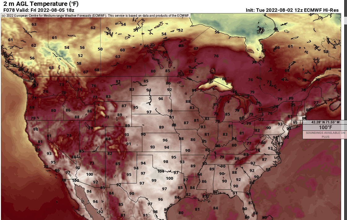
Looks like the 18z Euro took those odd looking giant Friday max Ts down some.
-
You’re not getting a hurricane this year stop it!
-
That may be your local sea breeze? SSTs at station 44005 are in the low 70 NNE if Cape Ann … also at the other buoy near by. Wind flipped onshore and I’m wondering if that drafted in dewy BL
-
Those Fri/Sat numbers along this eastern end of rt 2 in N. Mass are quite suspect - It may take place.. I'm not heavy handling you here lol. no but the problem is, it's got a tiny geographical area immersed in near or at historic heat, and typically, ..those kind of numbers require a larger/regional synoptic support. Friday at 18z the Euro surrounds this eastern MA region with a rampart of intense thunder storm activity, ...where's the outflow going? I mean, that too. Yeah, it's inside of D4 and the Euro's pretty darn good in that range. It's also had these intense heat island looks for two days - persistence. It'll be a neat event if that verifies like that, though. As far as the latter days.. yeah, it's becoming perhaps apparent the GFS was selling it's tendency to go out and kill heat - we'll see. It may take a few days to break this down. The Euro refuses to back off the WAR ridge retrograding W, that's more been there than not.
-
for some reason it feels hot to me today. 89/63 here as the average among home stations within a mile or two, which as you suggest, isn't the worst it could be exactly, but you know... I think it is the shear power of that pure unadulterated sun. That may be the purest blue possible at this end of a any continent in a CC era - haha. It really is instantly searing sun walking out there. Almost like the ambient light is so intense it is warming, not just the direct rays. Yet the air T is 88 I wonder if there's something to that.
-
-
00z MAV/MOS keeps Friday and Saturday just under 90 along the BDL-FIT-ASH-BED arc, with DPs 69 to 71. We'll see if the 12z edges up ... The 2-meter product at Pivotal is significantly hotter on those two afternoons.. 21z soaring to 95-98 hovering that product ( I love that thing by the way...) That seems like a huge disparity between the interpolation versus the raw model output ( MOS vs 2-meter graphics) - I wonder why-for? My sci fi writer wants to presuppose that the climate change is mucking with the interpolations, because they have a climate bias built into them. Don't they Brian? I thought I did - I now they used to back in the day but I've not kept up with Bulletin products - the display/accessibility NCEP is providing is much much improved, however. Lol - Anyway, 89 at BED and the hover product pings that at 97 is large. I wonder if in the past there's a few BDs or convection/cloud in the generalize warm frontal histories that are weighting the MOS numbers down.
-
Specifically ... quote a turn of phrase that was less than clear, and I will rephrase gladly. I'm a lousy writer.
-
I wonder if tomorrow and Friday are the worst aggregate "HI" of the summer - the period. Looks like 96/74 at NWS sites, and 96/77 at home Davis', for HI's in the 105 range, both days ...for real this time. None of this DP vanishing act this time - or less of it. And the lows tomorrow night? ooph 2-meter T layout looks too tepid with the NAM. But I'm not completely sold on the Euro's 98 to 100 from ALB-down the Mohawk Trail to BED... It's doing that because it has less DP... Hmm, it fits the season's dry motif though. I dunno - not a NAM DP handling specialist, so who knows - If the NAM wins DP and the compromise in temperature ...that's 96/73 sack sticker irritability heat... and would be the summer's HI acme.
-
LOL... but in a more useful, and fair representation of my "musings," precipitation is but a mouse in a stampede of pachyderm observations related to and/or likely being effect by CC. The elaborations I've written, that are either too difficult to understand ( blame the writer..fine!), or too inconvenient for others, is that the ENSO is tending to decouple from the seasonal atmospheres (summer and winter) with increasing frequency ...particularly spanning the last 15 years or so. More extended periods of intra seasonal pattern break-downs, where the modes stop "obeying" the statistical inference, are being observed. At other times, it seems to overly constructively interfere so vastly that this "clicks the gear" into the next registry, which displaces warm(cool) correlative regions down(upstream) - those that are at continental scales. This is screwing up teleconnector aspects ... this is a Pandora box. Either gives the allusion of decoupling or not - which is which? Point being, the ENSO reliance of 1995 doesn't apply the same way. We cannot logically, look at 1900 through 19 ... 90 and linearly predict outcomes. And that is before adding in that the ENSO doesn't operate alone - this is before that. If it helps ... it is documented in accredited circles, from private University sciences, to the IPCC reports. It is not merely 'conjecture' The stuff about the Hadley Cell expansion may or may not be physically ( as in ..wildly evolved mathematical physical equations and shit..) proven related - but I don't see how that can't be considered without adopting the admirable neolithic incompetence approach. It very well could be playing a crucial role in driving some or much of the above - and I personally believe it does. But, folks can disavow or accept or ignore whatever they will. But, to me, when the HC expands - as it has been noted in above publication sources - it does tend to weaken. That's important. The nature of the expansion - folks tend to mistake spatial growth with increasing power.. .and that's not right. Among aspect of the expansion, causing a weakening of the easterly trade mass-balancing flow; causing inner HC domain breakdowns resulting in eddy circulations; etc... it separates(disconnects) the ENSO sea-air coupled domain from the westerlies by virtue of spatial distance. Ahh..that could be a great place to start in investigating the aberrant circulation behavior...etc. Quick and dirty 'abstract' on that posit: These are aspects of the circulation mode that then necessarily would have to effect the ability for Kelvin wave distribution, propagation therein, wind and trade-flux related sea-surface stressing ... all which feed back on any tropical/subtropical phenomenon's ability to interact and influence the behavior of the westerlies ( through dispersion mechanics along the HC polarward boundaries).
-
But in order to take advantage of the sun, June or early/mid July being the operative period of time... It's a tl;dr posit of mine, but I believe these summers since the aughts of 2000, have been increasingly suffering "seasonal lag" - which is represented in an overactive mid level jets/westerly streams, claiming longer than the previous climate mode ( yup ... CC -related) would infer they should. By June, the R-wave's should be less constructive/coherent - this year it looked like February on the polar-stereographic 500 mb non-hydrostatic hemisphere... in fact, vestiges of that into July. I've seen this across multiple summers since 2010. But it alters the early to mid summer pattern behaviors. In one such way, reducing the length of time a region really can spend in pattern biases ... We're losing the 'stagnation factor'. Like, hot patterns collapse quickly... Cold ones role out and/or moderate almost while they are windy, and destroy MOS machine numbers, busting them too cold. etc.. Model supposition: As an emergence of all that ... it has a way of sort of protecting mid latitudes from the highest sun/solar insolation time of the year, because it's thus less likely to come into a constructive interference with any ridge, like that above, that ultimately can't really make it through the model gauntlet. Thus, they ( the models) detect these big ridge nodes as physically plausible ( so to speak), but they don't tell you that it is less likely to survive the unknowable future perturbation(s) of the overactive summer jet. The Pac NW last year/June, is/was an example of succeeding in overcoming... Which was as much an homage to the rarity in doing so. As hot as as it has perceived to have been in areas of the country, we've left some on the table. As far as I can recall/tell, we still did not have/observe the "synergistic" heat wave this season. Certainly not around here. But in fairness to practicality and realism... we're not likely to see a 300+ hour anything from any model source do much better than a blind man at the World Series of Darts without figuring out how to manipulate the quantum fabric of the continuum ..i.e., just control the weather - as a complete and utter failure of the tl;dr initiative ... that's probably more apt to be realized before model visions of that kind of extended outlook ever get very probablistically useful. We're wasting carbon footprint by running the crays out that far...
-
See … A, we can’t seem to ever get something like this to actually take place - even though we are frequently hinted that it’s possible B, it won’t seem to happen at the end of June - August 10 exits the solar max and we enter the solar transition season. So whatever maxes that could ever yield .. you lose some to seasonality. Ah well … may as well get that sort of thing going early sos folks be psycho babble prepared for winter…
-
Mm... not sure about that. To each his own opinion - teams can get hot, and timing is everything therein. The brilliant one's? They engineer their streaks. Not saying they'll succeed here - and in fact, ...I don't argue as of this moment, your more likely right about the 'not good enough.' But that may not be the case 1 month from now, given these moves and the expectation of getting talent back on O and D ... Their engineering. We'll see. It's not black or white with what, 60 games in hand.
-
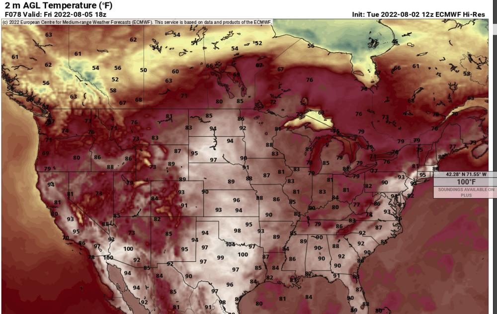
This is an oddity to look at ... here, the 12z Euro for Friday, 18z... You have 100's over interior eastern Mass vying for hottest spanning the continent at that hour, and it's so tiny and nucleated inside a weak low attempting to close off on the stalled front... ? Meanwhile, training bangers with probably, water boarding rain rates aligning from Pittsfield MA to Keene NH -CON, where it is 75 in southern VT. I would love to see all that set up that way.