Typhoon Tip
-
Posts
44,231 -
Joined
-
Last visited
Content Type
Profiles
Blogs
Forums
American Weather
Media Demo
Store
Gallery
Everything posted by Typhoon Tip
-
Could indeed be the beginnings of the seasonal "pre-lapsing" phenomenon. I'm hands-throwing expecting a synoptic -scaled October snow potential, or at minimum an atmosphere capable of hosting one ... Folks might have noticed an emerging leitmotif yup... I think this for the time being is more of an App. stalled trough that decays into a shear axis spanning these next 7 to 10 days. So probably more like S of SSW coastal DP flow. But the "act" initially of how the atmosphere is putting us into this immediate transition, yeah it does smack of what you're implying like an early suggestion of intent LOL.
-
They'll be in a pub with tall boys this afternoon then late or unusually quiet tomorrow morning with hang-overs. I was on house-painting crews back in the day ... like waay back there - 20 something's - and we didn't "waste" a rain or heat free pass afternoon. No way - woo hoo.
-
Just from orbit ...I don't know how easy it is even see 80. I mean the climate numbers show that's rare, but I wonder if some of that is just Earth. I mean, comparing other hot regions across the continent... outside of the SW, it seems even in Oklahoma during some of those heat blasts from earlier this summer, they were getting down to 81 ... 106/70 or something whack and then 81/75 at 6am the next morning... back to 105 I suspect it's just hard to do that around here and we chasing something that's even less likely observed than the elusive 100 F high.
-
I was wondering if in addition to frontal cloud capping ( at night ..) there is also some WC compression ahead of the boundary that assists, too. But of the two, probably the ceiling factor is the more directly measurable -
-
it doesn't help that there's a forecaster that lurks in that office that loves him/herself some colder adjectives, having [apparently ] lesser reasons required to get there LOL "Unseasonably chilly" - let's let the still potent, < 15th August sun work through a clearing from a 65 platform? I think it will be cooler - it'll be interesting to see how much so. Like "seasonably cool" is a kind of reserved turn of phrase for the way this looks that is available to the forecast vernacular. I suppose in his defense...it's denser clouds - not just summit capping - just N of the region over SW QUE so if that evolves in and you upslope... yeah. But right now it looks like sun is winning on the hi res loops.
-
The sun's doing it's magic... The skies are opened up considerably over the last hour - as mentioned might be possible. Still lagging across southern VT/NH - they're hillier terrain likely helping that, as those clouds appear like standing wave-form on the looping sat. It may just take long for to overcome. But the temps are responding very quickly. BED is actually 5 ahead of yesterday at the same hour... 83 vs 88. 88/73 but I haven't compared to other sources for rounding nuances. Doesn't matter. Point's made.
-
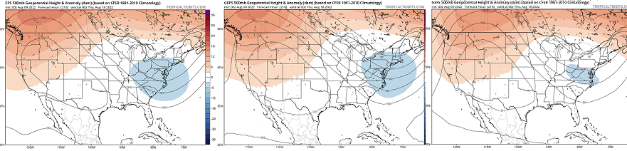
Soo... we're on the doorstop of a coherent regime change again. This one will be fully integrated. From top down and bottom up, it will be definitive. This trough careening along the 50th parallel of southern Canada, turns right as it nears 90 W ... From there, really plumbs down the 80 longitude line. By 200 hrs, the EPS/GEFS/GEPs ... other than very minor idiosyncrasies , these sources are remarkable similar - both in this scalar presentation below, but as that ~ time range comes and goes in their respective cinemas. A-priori experience, combined with climatology, ...tells me this period may be evolving into a "Bahama Blue" pattern. Defined by a coastal parallel flow, they may last a week. What happens is, the summer polar jet reaches it's highest latitude, and that leaves the region beneath in a quasi stationary tug-o-war between WAR exerting west, and this trough above.. - which actually in the process of retrograding toward 90 W. That situates the Eastern Seaboard in a regime featuring deep subtropical air mass training up via a conveyor that straddles the coast. On a personal note...that is one of my favorite pattern types. Days are steamy warm, but seldom big heat. More of the 86/76 variety. The sky-scapes can be a cloud geek's paradise, with topaz blue, adorned by bright white towering CU streets - just like a Bahamian sky might imagine... These will be narrow, fast moving, and can bring very heavy, albeit very brief downpours and then the sun reappears mere moments later. The temp and DP don't seem to move much. This type of regime has only set up maybe 10 times in 30 years ...but, I've seen variations similar to it. It's not either or. I've always wondered... what that would be like if a Cat 4 hurricane was nearing the SE Bahamas during. But alas... in my decades on this world I have never seen that happen... A flawless non deviating conveyor from Nassau to Mt Washington would constructively lend to a high confidence major impact with very limited dispersive solutions to offer any reasons for distraction. I don't know why - is there something about that circulation type that is inconsistent with general TC development/maintenance. Maybe in establishing one, physically makes the other less likely. Anyway... not sure bona fide BB pattern sets up ..but this above looks to match past observation that eventually clicked into place. There are likely individual members that go into the means above, showing more more parallel flow from the S along the EC. We'll see if it works out.. But either way, the era of the western heat expulsion into a flat trough with arid continental flow, transporting transparent CB ..otherwise, high heat, is on its way out.
-
Today may break the 95+ Logan streak, based upon early morning hi res satellite loop. We can't do it without more sun - obviously. I've seen hot weather encased below a cloud deck before but that's usually 88 when that happens. To get to and sustain 95+ spanning an afternoon, I strain to envision any circumstance where that is even possible in this region, when wanly lit by faux shadow insolation. Not impossible yet... it's early. The next hour will be critical. And as the sun rises higher it may normalize the RH that's trapped in that 750 mb layer up there... - if an air mass could ever bounce, this is definitely that type of air mass. So we'll see.. CT? no problem - their doing it. In fact, the same hi res loop shows just what I was talking about, and as the sun is climbing it appears to coincide with their sky trends.
-
I thought yesterday's morning low also was a nuanced butt-bang at that location because of the thunderstorm that rolled through 7:30 the previous evening... If that hadn't happened, that was definitely a candidate overnight for lofty low. It's been a record breaking journey that still managed to get nicked... I guess most heat waves are taxed some how some way, at this latitude and continental/geographic circumstance, either way.
-
Dude there are hundreds of mob bodies in there… Who are these people kidding in the media that act like this is headline and nobody knew it was coming
-
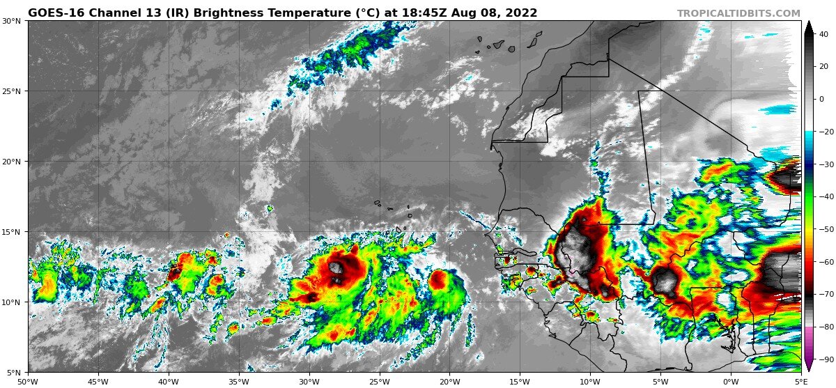
Heh now out of nowhere there’s actual TWs line up across Africa. This flirtation in recent guidance with MDR maybe the flurry?
-
Something bizarre is going on with these long range models
-
Pretty good anyway but doing so in August …
-
98?
-
Preeety sure tomorrow bumps 1911 to 3rd....
-
fwiw -
-
how could they resist ...what, with CAPE of 5 billion - That's what it takes for us to go from general to marginal, 5 billion CAPE. no j/k
-
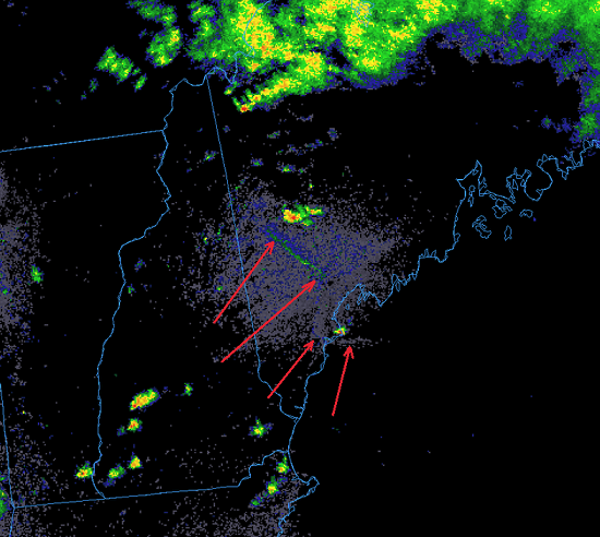
Looping this COD rad product's reflectivity mode nicely detects the BD in Maine...
-
Yeah I figured so... and when I read that I thought, after tomorrow ... it will bump 1911 to 3rd, and become 2022 as sole owner of the 2nd rank... I don't think Wednesday has much chance of even making 90 from what i am looking at - I think we have milk cirrus capping over 86/63 ...If we got a ton more sun than I'm seeing - which I dunno...maybe - Logan makes 92 or something. I mean not that you asked..heh. Someone was saying that Wednesday still looks warm to hot so just 2-cents.
-
There's more than one street of TCU ...the first of which may skirt S of you. But you can see on sat/rad that the patterns loading up with new one up stream - that may have a better chance. Notwithstanding any rogues in between. These are not corrective though. In fact, they are fast moving and perhaps adding fresh additional theta e to an underwear already sticking to the back of ballz
-
If the NAM is wrong about the clouds but right about the thermal plumb, it's 101 tomorrow in Metro west/Logan... You can see it at LGA ... 30000504928 -0996 112414 81332415 The aggregate ceiling RH's are all < 50%, with a WSW trajectory and a T1 of 33 C ... The 2-meter is likely 37 or 38 in that. The only difference between BOS and LGA is that the RH levels are > 50% in the NAM solution, which probably atones for the T1 "ONLY" being 32C up this way.
-
Nice... 97 at BOS at 16:54
-
... I'm so sick of the heat right now if we crashed to 58 I'd be dancing through the fields naked like Sound Of Music
-
Actually ..I took a second look and it appears there is more scouring. There's two features criss-crossing though. There's bowing punch toward the SW along the coast, which tend to be more west moving inland - that appears to be the 'front' BD. But then there is a bowing S of a [probable] region of rain cooled pooling. There a clumb of more aggressive CU where the nexus - kind of interesting meso features. Anyway, we'll see how far that all gets SW. I wouldn't be surprised if it exceeds guidance by 50 miles though... whatever the standard error for BL blindness is...
-
It's super shallow judging by these hi res vis features... There's a tiny fog front bowing along the boundary there skirting the coast but the CU field is floating over top without decay - it quite shallow, otherwise it'd likely abase those CU. But like we said it's probably just going to extinguish some momentum.. It's an easy corrective guess though. Are pressures rising up the Maine coast? If so, it may continue to creep.