

Typhoon Tip
-
Posts
44,231 -
Joined
-
Last visited
Content Type
Profiles
Blogs
Forums
American Weather
Media Demo
Store
Gallery
Everything posted by Typhoon Tip
-
What we're seeing in the guidance 'canvas' for this latter August has been stable in the guidance ... dating back some 2 weeks really. The projection back then looked as though more pedestrian heat would fashion the return dress... basically to finish out the summer. The snarks amongst us would diminish the notion in a breeze of 'well that's the climate timing anyway' typology but no. It's going to be above normal - most likely - during. And that still seems to be the case. So the big heat would come to an end. Since ..the 'coastal' ( if we wanna call it that ) did emerge in the interim, as an additional distraction. Frankly, this was really more of large sprawling, more modest +PP anomaly that enveloped over S. Canada. It orchestrated a broadly oriented E flow across really everywhere below the 50th parallel ... Kind of an interesting way to move from an en masse westerly-sourced heat signal, like a planetary correction. But once that set up, it instantiated a basal baroclinically unstable environment, along the OV to NE axis underneath... What the coastal lacked amid that region was sufficiently strong enough mechanics to really work within that favorable environment. Also, cold air. Moving cold air from E to W, N of warm air, along better defined boundaries are key circumstances. Nonetheless, enough cooling onshore flow did augment this interim 'mild-down' to push that correction vibe further. Really could have used the rain ... though. I'm not personally too concerned over the 3 month drying just yet. We need to press this through the autumn, then successfully strand the region in a dearth winter before I do - deeper hydro is minimally impacted - unless that's suddenly changed in the last 96 hours... Am aware we are in the top 5 ( as of last check ) driest JJA.
-
yeah ..cuz ya can't steal something that doesn't exist ...
-
Perfect weather here in Mi. 80/50 Kinda surprised that things even gonna affect you guys. The flow is so weak and only vaguely mechanically strong enough to guide a coastal system along. Probably why it’s been handled so atrociously … it’s on the edge of even being able to exist. Almost has a tropical look too
-
82/52 ... sun is searing hot tho -
-
Last night's Vegas downpour was excessively localized though ...there wasn't anything within 70 + miles of that solo cell as it went precisely over the city ...pretty much the same size as the city limits. Talk about dumb f'n luck -
-
This run has more actual short wave mechanics loading into the trough basin (albeit subtle) - something we hadn't seen. It's like the previous runs were opening up a deeper geopotential nadir, not based on that requirement. It's been the primary reason for my backing off the idea. That, and the fact that the GFS has been having to correct just about everything it ever sees beyond D5's, to something less percentage-wise in amplitude coming into nearer terms, since about 2014 () It's intriguing as a subtle but important difference. We'll see what the ens of the EPS and GEFies do
-
It's a toy, that's why. They just haven't had a chance to play with it.
-
You and me are on the opposite sides of the druthers ... sort of. I prefer a front loaded winter. The best example I have ever experienced was 1995, with close 2nd place perhaps 2008 then again 2010.. Those years had snow pack through all of December - check that on the latter two... may have been close. But definitely that was so 1995. So, that's going back almost 30 years at this point. It's hard to do the earlier, ..as that sample size alone less than delicately points out. So my expectations are pretty low any given year that I'll get what I want. 1995 I was attending college at UML, which is situated in the Merrimack Valley - in fact, the campuses total region straddles the river as it cuts through the N side of Lowell. It's probably really more of a southern-SE NH climate characteristic. But, that autumn started featuring large diurnal spreads by mid October. What's funny is this seems to conflict with warm spell memories of others that month, but it sticks out to me how many deep frosty mornings we had there after the first week of October. By late month.... there was ice on the shade side of the Pawtucket hydro- viaduct. The canal was built of granite slabs, tightly fitted...each probably 4 tons. The fascia stoop some 50 foot above the river basin by the time it hits the defunct hydro electric dam. They still use it to control flow rates...whatever - may not have that entirely right but that's what I always thought. Anyway, the water pressure squeezes through the seams between the slabs at trickle rates... It's normal. But it's kind of like those seeps you see along highways escarpment where the granite hillside were cut through to lay the road? Those rivulets were freezing by the 20th, and though the afternoons recovered to a crispy mid or upper 40s, by then the sun is so sloped that the N wall of the viaduct is in eternal cold shade, preserving those fragile ice features in the still cool air. Yellows and saffron hued trees dappling the hillsides gave homages to a world still worth being in. Jesus I distinctly remember that imagery, and thinking it must be early in the year to see that. I think that autumn was very gradient though. Like CT was near 60 on those days, and that may be why-for the varying anecdotal accounting. But, by early November ...it was clear, this was an unusual mid to late autumn setting up. I recall the recently decease Mish Michaels had stopped by the UML Weather Lab to tour the facility. She would later briefly tenure a professorship to teach intro to media... We didn't have that access as Met students prior to that; that operation up there was like Navier-Stokes jump off the chalk board and took on a daily form, and we lived each derivative. Where the f am I going... Oh yeah, she and I sidled up to a PC and observed the then, MRF model, churning out coastals on the long range charts in regular periodicity. We were commenting like any little wiener shnitzels would, about how it was plausible because the -NAO this ...and the predominating +PNA while that was happening ...were large scale hemispherically favored ... blah blah-blah blah. Dr Frank Colby rolled his eyes - serving as tour guide - and rolled back into his office while we drooled over the console. We were right. By mid month, there was a solid pack. It was sleety in nature, but plenty of snow. And it was cold! I mean, those first couple of gigs laid cake, but there was arctic cold by mid month and the Merrimack back waters above the dam were actually freezing some 45 days ahead of typical. It was a white Thanks giggedy... another storm months end... We were sitting on a foot of strata pack type from Acton to the Lowell... Not sure about CT-RI, but I suspect by then the polar suppression had engulfed all the way down. December? Forget it... man.. .I recall climbing over curb-side snow banks to access pubs down off Beacon street, with 9 F cold and vocal steam vapors falling instead of rising type blue nuts cold. By then I think there was 18" of glacier not going anywhere. Another storm 24'ed the pack into Xmas ...something like that...Then, we were biding time while the Megalopolis Blizzard '96 was emerging in the extendeds, with no means to modify the ginormous scale in mass of that eastern Canada and the NE U.S. cold - which loaded the region as the solar min was sweeping over the hemisphere ... That was one that you knew with exceptional early long lead confidence, it was either all snow, or no snow due to a PD deal... But there was no way it could like physically rain...LOL. And it didn't as we all know that are old enough to remember that monster. We had 35" of snow on the level a week after the Meg blitz...because there was another coastal that laid down an unthinkable new 8-12" It was a wetter snow ... The air smelled like rain while it was snowing. Perhaps an homage of what would transpire a week later... It was big deal because roofs wee starting to fail from weight. Then, the thaws.... removed it all!
-
That's only happening in a complete shut down overcast over saturated RH rains, which was the 00z layout... Again, I don't like the idea. The 06z is more keeping with trends, trends that fit climo and other synoptic reasoning related to persistence, and separately... model performance when relaying late mid range into mid ..shorter visions. We'll see. It's sort of an interesting test in an otherwise dearth of anything in this hobby that requires much attention - in fact, ...this aspect has already been given a lot more than it needs in a vacuum, but we have the hydro concerns drawing the focus.
-
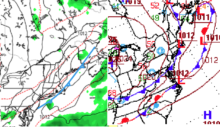
Fwiw WPC's recent sfc analysis suggests the front is too close to have effectively scoured your air mass just yet, and quasi stationary with a bump low. It aligns roughly up down shores over eastern Ma/Me...and even back here some 40 mi west of that idea ... that all means the momentum wasn't likely enough to completely cleanse just yet. That would be my guess... Here is the Euro's most recent run and it lines up the position ~ 9z within acceptable error.
-
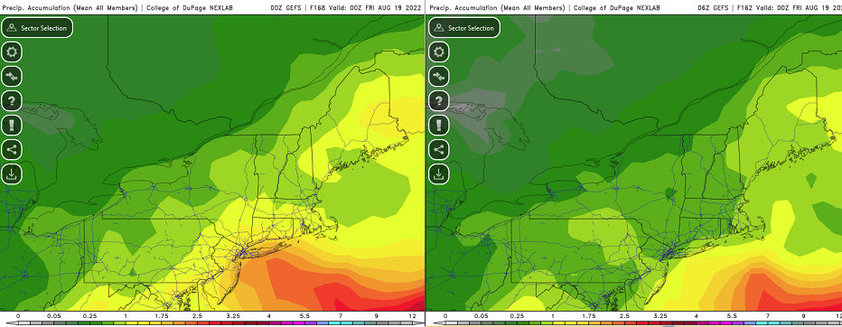
I feel like it's day five before a fading coastal in the guidance... It's circa some February 20, during a particularly frustratingly low performing winter season, knowing in the back of one's mind, winter is past middle age and its best potential may have already ended - it's now or never. The last five cycles of the GEFs mean ( 24 hours), cumulative spanning through next 00z Friday, have ranged between just over 1" total QPF, to ~ .7" Interestingly, the greatest and least individual run totals were this most recent 00z (most) and the 06z immediately right after ( least ). The Euro run more than less pulled the plug on substantive/corrective QPF yesterday at 12z's cycle. I haven't bothered to look at the 18z run...but the 00z run appears to have continued along the 12z thinking. The situation is both complex, and weak... And, if that were not enough, 'weak' in the scenario from Mon thru ~ Thurs, does not mean heavy rain can not happen. There will be a tendency to pool theta-e within the trough's basin. If this opens up more and allows more insolation...say, you go back the other way with convective downpours that may be slow moving given to the weak flow aloft and the slow synoptic evolution combined. It can manifest rains that aren't really seen by any ens mean ( certainly ...) do to small scaled coverage and resolution issues.. etc. The idea of a general cool synoptic refitting pan-dimensional QPF event appears to be lowering odds, however. I've already opined my broader encompassing reasons why that is actually the preferred ( likely...) result, anyway, but ...the period of time probably is not a loss for those really buckin' for rains/drought interests. Because, there should still be a general better mid level to surface lapse rates hanging daily over said pooling of theta-e, and so there'd likely be daily instability to give. These global numerical guidance types are not going to necessarily seed the field with TCU, so that's unknowable - just recognize the metrics and roll the dice. That all said... a 00z operational GFS solution is not impossible either, ...again, I personally don't feel that's likely due to the overall trend to shed the typical late mid range amplitude as this week is nearing, working with cross guidance trends.
-
The continuity issues are the 101 red flag. The other flag -for me- is that the trough expands without loading. It looks like an artifact of the models … sort of spontaneously calving out the isohypses. They then respond to their own error in developing (previous solutions) a suspiciously anchored low - based on faux deepening aloft.
-
I'm not sure the low ultimately closes ...and/or if does so, it may do so too shallow to force a response in the surface features. The trough appears to be deepening to me without an entry - it just spontaneously opens up in the flow. That's the non-linear/secondary result from changes in WAR moving E, and the ridge in the west retrograding ... I've seen the models do that in the winter, and they mistook as activated L/Ws - this happened in the 2020-2021 winter, near the end of January I think it was. It was more like a deep sag in the heights between - But you're right - the lack of b-c fielding is playing into that, as there's not enough thermodynamic feed backs ..
-
Probably ... I don't believe the deep layer organization of that though. I suspect ( and am happy to be wrong if need be) the recent 24-hr trend toward weaker in the Euro probably ends in an open, non- closed depression in the field with nice convective blobs... That kind of morass can rain, even prodigiously ...don't need a helluva lot of triggers to dpour if theta-e's pooled and there's still relative summer sun cookin'. But the whole idea of a quasi E- jet anomaly over a 1006 mb low that doesn't move for 30 hrs strikes me as a secondary/non-linear wave manifestation. The 700 mb flow is vaguely closed with like 20 kts of circulation velocity. wooo. The models have been gunning for a trough along 80 W all summer... consummately having to back off moving inside of D5's. There has been a tendency to nadir the flow around that longitude ... but the models tend to see things magnified at this range. This time there may be more, then their detecting a little more trough through that lens. Heh, we'll see -
-
Mm the 24 trend in the operational Euro has been to shallow out that 120 to 168 hour ordeal next week in the east. It matters because folks are asking for organized hydro but .. The problem I've been having - and still do ... - with that whole ordeal next week is that the total manifold of the trough its self doesn't appear to be arriving in the flow - the one over this next 24-48 hours, does. There after, the models ( all doing this...) are just spontaneously ripping the field open with lower heights. Then, as a response to that artifact, the create the giant 1006 mb low with all this rain... I don't think so.
-
We're probably getting way ahead of ourselves ... but a somewhat less cyclone model evolution opens up that canvas to that potential - I like the low LCL/0-3km vision that becomes if that mess opens up more warm frontal wave in nature - which I think has some potential to evolve in that direction.
-
All set -thx
-
UK Met Office Forecasts 40C for the First Time
Typhoon Tip replied to donsutherland1's topic in Climate Change
Fwiw - https://www.metoffice.gov.uk/weather/warnings-and-advice/uk-warnings#?date=2022-08-10&id=47fce950-e67b-4271-9a07-92ba94c1934a&referrer=rss -
HFD is 88 with a W wind. Boston is 70 with an E
-
mm.. one can envision whatever is needed to fulfill one's narrative - .. I mean, this engagement is not exactly held responsible to answering to a consortium of accreditation. lol But, the rip and read GGEM and GFS and their blend, is a straight up Nor'easter entry into an event that then takes a day and half to turn into left over murk. I don't even see much way to get the flow SE away from the coastal areas with that high N of the region pressing east, while that slowly busts open through those two days. It really more like just winds down to 74/68 with nimbus debris... I mean the whole thing still looks suspicious to me. They are way over deepening that thing..>They both seem to be responding to the non-linear wave function in manifesting that thing - not descriptively delivering wave mechanics into that region very well... Therefrom, then forgetting or ignoring the geophysical memo that there aren't enough baroclinic gradients, it's basically a December coastal storm 40F warmer... yeah okay -
-
hahaha... drought over! altho, technically we probably need two of those. but like you intimate, if it is going to go that far, it may actually synergistically go ballistic and turn into a real fun headlines like, "After months of drought nearing critical, New England floods catastrophically" who's with me! Actually, though ... my gut tells me this is the typical 'seen through the magnifier' range of the GFS, and that closed pig it seems to emerge rather than actually arrive there ( that's a potential hint -), will end up being just a general S conveyor up the EC. The weekends interlude into 70s/50 chamber will give way to a subtropical sky and that big QPF spreads out over three or four days/less. That is a very late March look though, to have that kind of sultan low plunk in there -
-
Not really relevant for you guys up there but ... the last BD I recall was perhaps June - this one was "cloaked" in the other boundary, making it less obvious, but it was very real. Spooky drowned sailor's shrouds ghosted across the sky under moonlight at 11pm last night as the smell of salt marshes penetrated the streets some 30 miles inland. It was beautiful, actually... But .. it appears it's terminating this hour as we speak. There is a clear delineation on higher res vis loop that suggests the interior cloud level wind field is turning back W, while this roughly E of Worcester Hills struggle to pretend it doesn't have to give up ... heh. I have more direct, non-orb sun shining in splashes now and we've jumped back to 76 here in town. Far cry from the 97 yesterday at this hour. But, as I was pointing out this morning and is still the case... this air mass on this side of the main/real synoptic front is still warmer than normal. We are getting a disproportionately cool enhancing by virtue of the low level NE jet that materialized over the last 18 hours of this BD fist. But hydrostatic heights being 575 still and even 570 mb up where you are, in this air mass...is NOT a CAA environment. So clouds and other nuances appear to be ganging up - so to speak - in making it appeal cooler than it really "should be" - I'm noticing now LGA on the NAM grid is back to 26 C tomorrow, and 25 at ALB... That's upper 80s in the 2-m - really where today still could have been down this way if this BD didn't steal time. Interesting... We all will, far in a way, get into a more convincing corrective air mass this weekend though. Probably upper 70s here to low 60s in the summits up there, with very low DPs... There after, I'm still thinking that the trough retros and we start considering a S EC parallel Bahama tap. Something like this as we write the last couple chapters of summer.
-
Breaking backs aside ... I've often thought of August and February as the real beginning of transition - so I agree with Ray in principle on those two months. It's like the zygote of the ensuing season's life, but still too small to notice. Usually have to get several weeks and a missed cycle before it dawns on the wife, 'gee, uh...wait a sec. oops.' But us nerds notice everything ... like, exiting solar max this. And 'shot across the bow' air mass that... The truth of the matter is, it's not a hard seam in time. It's like crossing the event horizon of the black hole: you can never go back, but you don't notice much of anything unusual or different for the experience going across. Pick one's metaphor. But we do, as overtly focused folk, notice the creep. Some years it may be more obvious than others. But it always strikes me as interesting how, the difference between May 10 and August 10 - excluding BD butt-bang years - is often much less noticeable than the difference between August 10 and November 10 ( sometimes even as near as September 10). Same is true for February going the other way... In either case, those months are an blurred boundary whence the corrections moving forward switch. Think of it this way, in 45 days, we enter a month that has snowed some 10 event-years in the last 20 One cannot really know that from July 1 to August 15.
-
Use logic though ... It's actually probably more exposing who's butt is sore when attempting to end -around climate and logic this early in the year by prematurely appeasing one's self with incongruous claims LOL J/k dude
-
It'll correct downward over the next week ..obviously - but... that's pretty impressive as a 10 day aggregate mean in August. It's actually rather under the radar extraordinary - I guess that goes without saying as it was exceeding a record not touched in 111 years so yeah ..It was extra ordinary. Anyway, it is much easier to put up a +8.6 day, as well as a week long, in January than it is in mid summer. In terms of that relativity, a +8.2 in August is a > SD for 10 days than it likely is in the middle of the winter. Earth likes to correct the temp up in the winter, but there are physical limitations at the warm end of the spectrum.


