Typhoon Tip
Meteorologist-
Posts
43,831 -
Joined
-
Last visited
Content Type
Profiles
Blogs
Forums
American Weather
Media Demo
Store
Gallery
Everything posted by Typhoon Tip
-
...and, one should expect with higher confidence, that barrier flow will cease to a new paradigm right around the 2nd week of November - any guesses on what that new paradigm will be/mean ? mm hm...
-
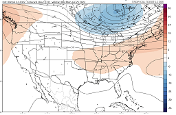
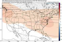
It's not convincing though... (for me). There's a WAR flex going on after a week in the ensemble guidance, but all modeling I've seen whether in singular depiction, or aggregate techniques, express it's expanding heights up the EC via accelerating mid level ambient wind flow. It makes that era prone to side swiping cool fronts despite the heights Typically, the WAR node expands and gains height, and then ..retrogrades toward the EC to eclipse and then continue expanding W ...etc. That's the typology. The models are doing the retrograde climo, but they are pinning the westerlies in position and thus squeezing the retrograde underneath. This enhances the westerlies wind velocity/ambient summer polar jet from lower Alberta to New England, instead. Thing is, you wouldn't think we would be looking at 95 on Saturday, and a possible 98 on Sunday, when looking at this circulation mode, So, there's no reason or necessary logic in presuming that this, won't also host blazing air masses... In fact, this particular 240 GEF's mean (500 mb anomaly) perfectly illustrates the WAR retrograding under a squeezed flow. So there are signs we could roast ..but that flow still could be reserving the right to sore-butt a forecaster's foresight. lol We seem to be observing some kind of planetary agglomeration of physical processes, the emergence of which creates this unrelenting super synoptic barrier jet ... pinned in place, that is a WNW flow across SE Canada. The WAR is present in this latter image above...but it's being ablated by that grinder
-
Severe Weather Threat Week...so many threats!!!
Typhoon Tip replied to weatherwiz's topic in New England
I can see the vil and crispie feeders from here. -
Severe Weather Threat Week...so many threats!!!
Typhoon Tip replied to weatherwiz's topic in New England
I'd watch out from MHT to CON -
Yeah..so Sunday looks like a hundo contender on this Euro cycle.
-
Holy hell at BED... Decimal/rounding games, notwithstanding, but 97/70 soothes a HI of about 105 -
-
You may get your WAR August I'm not hugely impressed with heat days 5 through 10 when utilizing the 500 mb non-hydrostatic height cinema. I see too many opportunities for side swiping shallow house cleaner troughs... It looks like once we get past Sunday it may be a week of 89 --> 86 --> 90 --> 84 over 60 DPs, then we'll see if that complete and almost scary looking HC expanding clear to lower Canada has any legs. If it does, that would interesting in that first week of August. Again...just going by the 500 mb evolution of the heights. Usually... that metric "winds" over the surface - That all said, the GFS has a particular gift side swiping troughs no matter what is happening - so
-
Severe Weather Threat Week...so many threats!!!
Typhoon Tip replied to weatherwiz's topic in New England
Classic cell split.. . Meanwhile, linearity formulating -
Severe Weather Threat Week...so many threats!!!
Typhoon Tip replied to weatherwiz's topic in New England
You're into watching, are ya - -
Severe Weather Threat Week...so many threats!!!
Typhoon Tip replied to weatherwiz's topic in New England
gotta watch those -
Severe Weather Threat Week...so many threats!!!
Typhoon Tip replied to weatherwiz's topic in New England
Just gonna say - looks suspiciously out on it's own like you see - -
Severe Weather Threat Week...so many threats!!!
Typhoon Tip replied to weatherwiz's topic in New England
This is actually kind of impressive... Despite the heights not really falling much, there must just be too much CAPE that when mixed with bulk shear ..etc. Cells erupting in S Vt/E Ny... N Nj as well... S-N orient (apparent) orographic assisted CU towers along and E of the Berk spine probably cuts loose soon. 92/74 locally ftw - -
Severe Weather Threat Week...so many threats!!!
Typhoon Tip replied to weatherwiz's topic in New England
Massive watch area... wow. Pretty much all of New England. -
Hm... not sure I've ever seen Logan 91 on a S wind...
-
I'm sure it's been advanced over in the convection thread by a large areal coverage watch is posted -
-
But CC abandoned the trough mechanism.. LOL... I bet there was a time in the distant solar-system's earlier life, prior to Venus' run-away CC ... when their atmosphere always felt like a thunderstorm that could never happen. I'm joking, but this SPC and slight risk and all that, looked much more promising to deliver back 4 days ago... But since, like all troughs have done this season, the models slowly backed away from the bully arrival and that's sort of lowered expectations some.
-
wow... it's 81/75 in the foggy strata down in New Bedford. Prolly more sun getting through than the satellite would suggest
-
heh.. you beat me to this by 3 hours it appears. I wrote about that in my usual tl;dr way an hour ago, agreed - although, I added concepts.
-
I didn't even notice that huge fog/strata bank from SE CT across all of southern RI into the New Bedford region of Mass. Looking at the satellite ..that appears a part of very rich low level/warm theta-e arriving across the outer cooler shelf waters.... That whole miasma is tainting the S. Coast. Should stay east of your location, but ..that 75 DP you're putting up this hour probably hearkens to said rich air.
-
Heating up more proficiently in the interior than the coast... SSW flow is already tending to bend S along shore points... May have to contend with marine contamination shortly up to a interior SE Mass and certainly Boston.. But ORH and FIT are both at yesterday's readings, per timing/hr ... within 5 minutes. 86 at at 9:20 in FIT seem like 88 by 10 is doable. Same is true down in HFD/BDL although BDL just noised their way back down to 82. S wind is odd for larger heat numbers...but it is very light. There is a modest c-front approaching - we should be more SW. Maybe we're yet molting off a shallow decoupled layer just yet.
-
This is an extended heat wave. I'm pretty sure most sites nicked 90 ( the old 89.9 er) Monday (chk that), and maybe low 90s Tuesday ..then of course yesterday. Looking at machine interpolations, it's 91 to 97 through Sunday... so the beat goes on. I'm thinking the mid and particular late mid range the global guidance' are tending to moosh the heights too far S into what's evolved into an impressive garland around our side of the hemisphere for subtropical ridging. So vast it is getting more difficult to see the acmes embedded within, whereby the lower latitude R-wave 'roots' are situated. The 06z operational GFS is really onto this idea, with a whopping 600 dm tickling ridge max embedded in and very large 594 closed envelopment of WAR heights, partially eclipsing the MA, forcing the 588 dm contour into central NE... around D10. Notice what it does two days later... It attempts a Rosby roll-out through the west and completely demolishes that look with another of these (likely..) exaggerated +PNAP aspects that have proven to be in the 20%tile too much all season anyway. I'm just not completely sold that these westerlies are going to be so obtrusive S of the 40 N during the last week of July into the first week of August. Another hint, both the EPS and GEFs mean ..right out to 300+ hours, almost never show the 582 dm non-hydrostatic height contour as successfully plumbing S of ORD-BOS latitude, despite having vestigial +PNA signature to the overall structure - which is an interesting tandem. It's not typical to see very cool air succeed S of the 45 N at those height persistence'
-
Unless it's cloudy ...I've seen it 23C at 850 and 27C at the surface under clouds the whole day before.
-
I think he was directing that toward me I’m interested in Logan late high phenomenon and as he lives there we sort of keep track of these opportunities
-
Really? I thought it looked troughier again so didn’t see the need to look at anything else - heh
-
monitor the late high scenario too - the E wind is down to 5 mph and the hi res vis late imagery suggest the breeze boundary is slipping back E... They may sniff SW suburb farts yet -


