Typhoon Tip
-
Posts
44,231 -
Joined
-
Last visited
Content Type
Profiles
Blogs
Forums
American Weather
Media Demo
Store
Gallery
Everything posted by Typhoon Tip
-
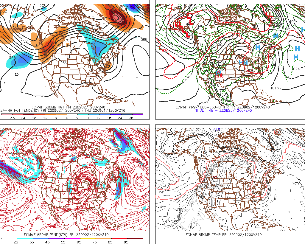
Here we go again with another ferckota solution by the models with winter looking L/W structures in the midst of towering heights. Meanwhile, ...it's +20+C at 850 mb over N Manitoba - I'm gonna go ahead and aver that trough of New England is partially bogus, as well as >90F almost to Fond Du Lac Saskatchewan

-
All due sympathies conferred ... We are too even down here along Rt poop - the N-NE Mass reason we're really CNE climate zone regardless of all asshole reasons otherwise. Convection is dying and or drifting over top as a remnant light rain ball pretty much right where that band of clouds set up all morning and didn't start moving N until 1pm... Said band was where the nose of that barrier jet butted up against the synoptic SW flow. Even though we were not in the deep N flow, we were still indirectly porked by it. Funny... one might not think of clouds as synonymous with drought, but the clouds are not allowing the rain to get here.
-
SE zones look like they're getting hit solidly
-
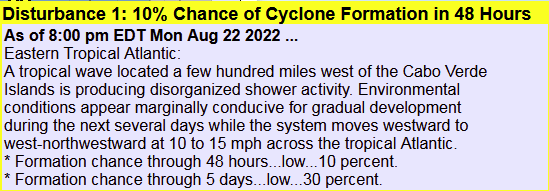
• Ongoing Kelvin Wave activity has led to an increase in convection across Africa, with easterly waves beginning to propagate across the Atlantic. This may lead to an increase in tropical cyclone (TC) development over the Main Development Region corresponding with the peak of the Atlantic Hurricane season approaching.
-
Looks like the synoptic flow is beginning to win the battle as BKN ( bacon skies as we used to call it...), along with a SW--> NE movement, are vis sat loop aspects pushing toward Rt 2. The band is shrinking that demarcates the convergence between it, and that barrier jet that set up eastern-CNE this morning. May end up with some sun and furthering destablization here in the interior, after all. We'll see. Boy...it would have been nice if that "quasi" Miller-B got going just a little sooner late yesterday, because it might have organized a broader swath of drought corrective rains right up eastern NE where it was/is really needed.. Maine got pummeled -
-
Yeah...I didn't actually anticipate today's convergence sort of stagnating this band through Massachusetts, this time yesterday. I had more than less visualized a day characterized as SW flow with striations of convection firing off ...more like what it looked like over eastern PA yesterday, but up here. That barrier jet up in Maine is butting up against the more synoptic flow trying to erode/push up from the SW, and the two or confluent here. Still air at 74 and dense strata for now.
-
Yup... It's one in many "Fermi Paradox" explanations that are out there - using the FP to help elucidate the notion. As an extension of the bold, the a evolutionary process that made that reality what it is, effectively ...annihilates the evolutionary process. The catch-22 is a stage most civilities in the cosmos have to successfully evolve through, without either degeneratively turning insular and wasting away, or ... blowing themselves to kingdom come. ...Most do not successfully evolve through that stage. And that is why we don't see a cosmos lit up by the after glow of civilities. I mean...there are other explanations for the FP, but in so far as what it means for us, humanity could very well be on the brink of either degenerative fade, or cataclysmic self-annihilation pathways to extinction. The reason why is that, in the case of our species, we don't store moral memories across generations? They are taught. When population is taught of only conveniences, the virtuosity in knowing how one's provinces come to be, become assumed - I would say entitled, but it really is more like 'unknowable' to consider otherwise. Before ... 150 years ago, the world was a realm where survival required most of daily attention and intelligence. The alternative now? ... gratification like you say. After a couple few short generations, the proclivities you call them are what people think of first.
-
I wrote ad nauseam about this years ago, on this forum, that I was not sure why GW necessarily means more. Folks likely don't remember - in general around here, that is true. Ha. Kidding but mainly because I was ineffective in communicating the hypothetical bases for my argument. Some may recall. All activity in the atmosphere is based upon restoring forces? There is nothing else. When A=B ...there is no gradient. When A is > or < than B ...there is a force moving in the direction of the inequality arrow. That is weather. If A=B (perfectly entropic) nothing happens. I suspect Scott's question relating to HC expansion is on the right track, based in principle on the former quanta. The HC may in fact be interfering, because at a principle level it might be lowering the deltas ( < or >), wrt to the vertical sounding of the tropics. I've never circled back on that, but I've always wondered whenever I see mass media generated headlines... Tropical Meteorology ( a course in college): there is a typical initial condition sounding structure for vertical temperature and DP, from the surface to aloft, that TCs rely upon. The temperature does not typically represent the unstable lapse rate. The DP gradient between the bottom and the top, does. That's the A potential to move toward B. When the convective process is ignited ... usually by converging sfc vectors... the TCU sustains by way of huge adiabatic heat release. A warm ocean ...definitely supplies an elevated DP source... That's a A > B ( in principle). GW stores more WV ... so, we are elevating DP in the troposphere? That would lower the gradient in the tropical sounding - it seems that is possible. But it's not a black or white, all or nothing, either. It could suppress frequency, but then should a favorable atmosphere transiently evolve over the GW lower troposphere and oceanic coupled boundary layer, it may mean more Category 23 histrionic hyper bombs. The frequency side of the debate, I wonder also if that is being exaggerated by more finite detection, utilizing all these technologies that were unavailable to previous generations. Not sure on that either... Recently I've connected with the notion that an expanding HC does not mean a more intense HC. For all my harang re the subject matter over the last 10 years ... even I was less than clear on that aspect. But it is indeed true... The circulation eddy state of the HC is also weaker, as it spreads out and encompasses greater latitude. That could be a destructive interference.. If the deeper layer easterly belt of wind beneath the HC ( within 15 or so deg of the Equator), is weakening, that increases the ambient shear potential. Between a warming theta-e world, and large scale mechanical changes ... et al, there's reasons to question the notion.
-
Wednesday May be the highest DP of the summer
-
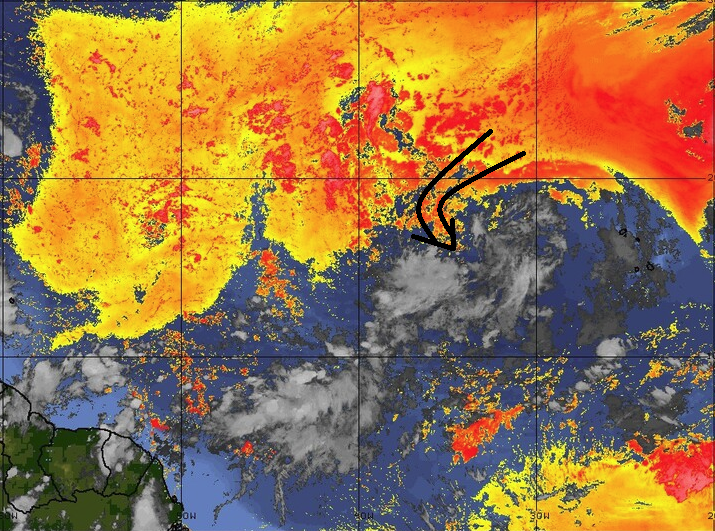
I agree ..the ambience is marginally supportive for TC genesis... not"wish"standing, the cloud features do finish as cyclonically curved at a glance. However, and what they don't mention, ...SAL appears to be ingesting it's poison - for the time being.. Not that anyone cares or nothin' ... They do say low chance so meh. Probably covers it. It's just that the operational guidance are trying desperately to ruin my irrational hope that the Basin will put up a zero August during CC.
-
So this thing produced more rain than that "coastal" last week ?
-
That 'meso low' leaving the Harbor looks like it was buckin' for a tropical designation ...
-
that umbrella should be a cosmic d-do ... There is no consoling in an engagement that really has less to do with weather. Oh, there is some weather in there, but it's vastly more so a weather-related-emotionally-guided on-line support group, and always has been heh The only way to cure that is to therapeutically uncan the history that left voids... This inCREdibly healthy alternative instead recreates their fear of abandonment issues. 'Daddy's coming home' 'Mummy really loves you ... which, neither turned out true. Or an old g-f of b-f ... some systemic abuse. Pick one's proof of no god. They couldn't control the outcome back whence it wired their unresolved psyches. The utterly untamable wind is just like the daddy or mummy, love or circumstance that demoed zero regard for them. Weather blogging by Dr Joyce Brothers
-
Rad suggests there's a N to NNW motion... Most areas out that way are getting pelted E of ~ Tolland HFD line from the stuff that came up over eastern LI... NYC appears to be warm sectoring or is about to
-
Warm frontal position has been redrawn since the 13:31 update. WPC has it slammed up against the S. Shore ..pretty much cookie cuttering the coast-line. Along with it, the lift region over the elevate frontal slope has realigned through CT-RI into SE Ma.... In short, the region may see more prolific downpours rain types than just a strata form - this morning I was speculating that may result, but seeing as the synoptics continue to evolve toward moving the w-front actively N, it's no surprise we see heavier rad returns in said areas. Tomorrow still looks air mass clappy
-
I almost wonder if the modest convection signal percolating over the interior for Tuesday ( tomorrow) afternoon might be more successful. This stuff this morning is pretty clearly over-running/elevated convection as the weak environmental 0-6km flow runs over that warm boundary extending seaward of the lower Jersey coast. As it ignites along that sloped elevation (frontal interface), the elements/cells then lift N/NNW tantalizingly but spreads out and becomes more diffuse because they're raining from higher elevation as they come. Fuzzier by the time they get toward the Pike. That's pretty classic overrunning behavior - use to be called "strata form rains" where the cellular look becomes smeared.. However, the total manifold of this thing is similar to that ordeal last week that almost failed to develop a coastal at all - just enhanced NE winds for a day... In both scenarios, the governing kinematics are weak. I'm not sure this has the nuts to 'fill in'. Looks like fractured coverage with gaps ...I think that's what the Euro's been trying to signal. Frankly, the NAM ... despite it's overall synoptic uselessness, is having trouble tilling .5" on the FOUS grid while being inside of 24 hours... Hate to say, not a good sign. Tomorrow, the warm boundary appears to get to about ...I dunno may SE VT over to PSM, but is losing identity as it does. But that's when we may destablize. The sun more able to penetrate ...heating and bubbling towers.
-
A buddy at mine in Auburn was under that slow moving street cleaner yesterday. His station recorded 1.61"
-
Heh...18z NAM is in with a stunning drought correcting .12" at Logan... but at least it's got close to .6" at Albany -hey
-
"...Only white man would be so careless as to make smoke in the open for everyone to see "
-
Yeah it’s been known and discussed for quite some time going back decades actually. The idea is that for whatever reason there’s some 30 year return window for that kind of behavior. I’m not sure if anyone et al has formally researched any sort of correlation versus causality but looking at those spreads it does kind of suggests that there is some sort of periodicity involved. Faux platterns can emerge in nature sometimes and given longer periods of times prove to be random, as well.
-
Lance Bosart ( UofAlbany) gave a presentation which attempted to link active autumn hurricane years to stronger Greenland polar vortex tendencies (+NAO) during immediately ensuing winters. I saw the presentation... I want to say it was given at the SNE storm conference back in the aughts, but it may predate that. The AMS/New England one up in NYS back in 1996, but that may have been convective focused now that I think about it. Bosart's (et el) was based both in part statistically, and a-priori/experience ... ( which I guess really implies 'responsibly anecdotal' in the latter sense) The basic theoretical framework is that re-curving cyclones feed latent heat ...reinforcing the l-wave spatial-temporal distribution, in which the PV coherency emerges - It makes intuitive sense.. The baroclinic instability would theoretically enhance whenever episodic heat plumes deliver into a region that is right next door to a heat sink AO domain/Ferral easterly circulation manifold at higher latitudes. It's huge potential vorticity ...realized by storm genesis. Therefore, the seasonal leading behavior/proficiency may serve as a means to predict the NAO index modes during ensuing winter. The problem is, when I search the web/archives for any papered work, it's always leading to N Pacific ... But I was there. He talked about the N Atl and the PV there in this context. I can think of counter-point/arguments too... Like, winters are long above 40 N, whereas the Atl TC stops that activity by late October ( typically...), such that it's forcing would surely be washed out by the pummeling maelstrom of Pac loading forcing the N/A pattern - given time. So it may be more useful earlier in seasons. I mean I'm not sure ... just conjecture there. It could also be ( and related to school I happen to agree with) that it is an index reinforcrer, but not a drive.... When the Pacific --> N/A --> +NAO, and the tropics are delivering, that is a constructive interference, and vice versa. He's emeritus at this point, but is lauded as a world-renown theoretical synoptician. I mean this isn't some influencer's opinion. ha.
-
..mm hm.. .and I was wondering to self this morning, if we can get through the next 10 days without realizing one of these GFS buckshot attempts, would this Aug be a candidate for low monthly record?
-
I haven't been in the region over the last week, but ... prior to that, for the longer haul of June thru mid Augu... I don't recall the DPs being very high - thus, not a very "humid" summer. June was cooler than normal ( ...if by relativity but I think it was in the scalar values), and July and so far August are even more so above normal in terms of absolute value. So, the summer as a whole is likely to end above normal in temperatures - that's easily measured. But there have been a lot of a 95 days with DP settling down to 58s. It's tough to run aridity in the soils and then celebrate drought histrionics both concurrently within a DP rich environment. Just a refresher course ... DP is a thermodynamic temperature intrinsic with the presence of water. Drought is the absence of that particular component. So, ... conceptually a humid summer is not supported; pretty sure we'll find the DPs have not been anomalously high as well - but that's not a declaration. Just a guess
-
Doesn't look like ^ is working out as well as initially it looked. I don't know were the DPs scheduled to crash this hard mid day? BED sunk from 66 to 53 ... impressive.
-
With additional DP moving into the region the temperatures may be a tick or two traded downward over yesterday's highs.