

Typhoon Tip
-
Posts
44,236 -
Joined
-
Last visited
Content Type
Profiles
Blogs
Forums
American Weather
Media Demo
Store
Gallery
Everything posted by Typhoon Tip
-
well ...it's a bit of an off-topic but I for one haven't lost any faith in the Euro yet. I'm still seeing subtleties and nuances that make it more valid than all other models. I still raise an eyebrow just as much as I ever have when it's crossing from D5 into D4s. I suspect some of it's performance being obscured by the din of over zealous nit-picking in this particular public opinion contributors. - an opinion, that is highly guided by the superficial specters of 'showing solutions' that aren't as entertaining. I mean there's a little gaslight there ( sounding ) but it's an honest opinion. This last system? I completely give it pass on the fact that that it was west-north of the GFS at D5 ... because a, it was correcting at the time. But more important, b ... it proved more right with where the better snows and cold ended up aligning. That's the nuance part. The storms over...no apologies conferred. I wonder why, gee. I don't think it has done enough terribly wrong to warrant what's been going on with that model lately. Just sayn - I don't.
-
It's really truly remarkable how brilliant this signal has become... even since starting this thread - it's only become more so... It really feels like we're forecasting the 2ndary wave function? -the non-linearity of it is that it is immensely implied, but is just not explicitly described. It's really like we have a high confidence forecast that the forecast will eventually have to be made - f'ing fascinating!
-
I mean just by observing the deltas between runs of the respective models, I've (personally) been seeing sensitivity related to the ridge response immediately aft of the trough ejection out of the west. When those surge more, there appears to be more momentum --> E, wrt the larger-scaled total (RW) wave space layout; the whole structure then finds the teleconnection coupled negative, that is in the process ( spacial-temporally) of passing through the ~ 90W longitude. That negative which is SE of the west fading middle Canadian 500 mb positive anomaly - timed well. And viola! the amplitude emerges there - if we go back and look at the oper. EC runs, those that did attempt the early polarward commitment ( about 4 runs ago) the ridge was depicting flatter along the backside of the ejection. It's really been pretty much 1::1. I suggest there is argument (valid) for needing accurate assessing wrt the larger scaled d(PNA), its relay into western N/A and the transitive forcing to play into over eastern N/A. This has been more evident in the ensemble means of all three, too. But, it is also evident in those op. Euro runs that came back E vs W with the amplitude. I'm really impressed by this clustering by the EPS... that is pure M/A bomb right there. There is a mode on the west side, and 2ndary depth mode that is deeper than the operational. Ha, just to point it out for fun...there 94x mb 150 mi E of Cape May.
-
I'm vehemently more impressed with the blend of the EPS/GEFS/GEPs, both in situ on the 0z cycle, but then wrt their individual trends, than I am any operational run. The spread in those is clear that there is too much difficulty seeing the trees through the forest during a pattern change - the specific advent in those guidance appears really yet to emerge.
-
Completely redrew itself the previous solution was quite unsupported all along … matter of time. obviously not done either.
-
...and like a different thread
-
Gosh, it really sneaks up on you. I mean, yeah...the calendar says March 4, but I was just scanning machine numbers for tomorrow and it struck me that climate is now mid 40s. It's sort of over and we're really getting lucky looking at this pattern we are - ironically considering... We're likely to have to deal with some winter threats over the coming week(s) but in the meantime... if we can clear out better than the models tomorrow, MOS has light winds while nearing 50 in the interior lower els. Under Mar 5 sun that'd be a real nape day. The ceilings break, but not until like 4pm and that's too later in equivalent October 8 sun ( altho I hate this comparison.. why do we feel the need to compare Mar 5 sun to October 8 sun? Just call it Mar 5 sun) but it's close, and with some d-slope trajectories on-going. egh...it'll probably self-destruct
-
Folks need(ed) to look at the whole run Meteorologically - and by that, I don't just mean all 10 days.. .but look outside the myopic low pressure and where it's doing whatever. The whole run is the hemisphere... I mean a lot of this is not intuitive. I get that. But the vortex in this run can't get N of Michigan in that look. There's no large scale circulation mode capable of moving it bodily into Canada. A region in which ( also ..) features a giant train wreck of constipated features. The main issue with this run that drives the difference between it and the 00z, is the handling of the western heights as it is being ejected E (behind..) That is flatter on this run. If/when those ridging structures return, this goes away from the Minn. squeeze back to just being an E expression. It's a not a terrible run if we know what to look for/recognize the surrounding constraints.
-
Actually ...what it's doing is attempting to 'Minnesota squeeze' an exceptionally powerful vortex.
-
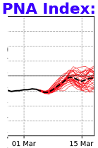
Yeah... I think maybe some jumped the gun a bit on thinking we had a consensus formulating ? but either way, we're still in signal recognition and ensemble structuring. I mean, we can argue we should by now, for a Mar 11 ( say..) but not really. Because this appears to be dependent on correctly physically processing what's happening on the other side of fairly substantial PNA index change. The deltas have to be right, which they seldom are, first. It's like trying to see ( model ) through performance boundary.
-
Judging by rad and synoptic obs ..I'm calling this about done here. Sun's dim vis, too. 35 with flurries presently. glop bombs splatting under trees and the snow's mostly slid off the car on it's own. I may not even shovel, as I don't have anyone at this residence that is at risk because of it, and it's going to be high Mar 5 sun tomorrow to laze off the black top like a Tripod in War Of The Worlds... That should take care of the driveway... half kidding. But with this my seasonal total is now 31 inches.
-
I agree with this surmise ( bold ). In fact I was thinking about this very aspect this morning. How the d(correction) aspect, the Euro's total 7 day aggregate may have had to correct more, but ... once in short range? it seemed to perform pretty good/better than the GFS. Now...I'm not willing to give it 'complete' credit inside of 48 hours though, because it had rain to southern NH. I'm not raining here... at all. It just snow too wet accumulate, under a day glow Mar 4 overcast. It's actually cold enough to have been a much better player, if the GFS dynamics verified as far S as it had. It's basically busted N of the GFS the way it looks to me.
-
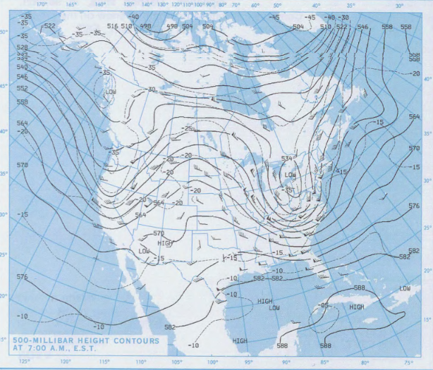
"bowling season" has it's own rewards ...even if the return rate on that is very low. April Fool's Day storm in 1997 was ... actually, I wanna get this off a nerd's chest. It's always bugged me a little that people think of April '97 as this bowling bomb. It wasn't the best of examples. As this 500 mb snapshot, 12z on the 31st of March shows ( courtesy NCEP library), the event was preceded by an integrated relay from the west. It sort of did take that on the next day ...but, it's hard to differentiate this below, from just any deep trough cutting off during the winter. I suppose the 'omega' construct overall sort of makes it both...but that the lead up to it was all an integrated wave propagation and less a bowling ball
-
In fact ...it's not beyond the realm of possibilities that the hemispheric appeal in that annotation above, and the empirical measured anomaly change in the SST ..., are indirectly connectable (physically) with what's going on in the whole planetary system. What's the SOI... ? Are the lower lat wind anomalies changing ? It may be that the whole hemisphere is just up and moving away from the La Nina scaffolding, and so the upwelling is abandoned - ... just venturing
-
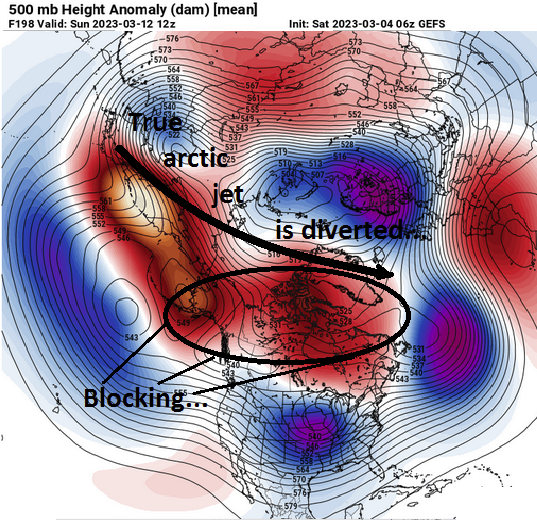
I'm not sure about an "arctic" shot. Gelid, sure... Thing is, the 'blocking,' as the western limb -NAO fades ..it really smears west across the Canadian shield in ensemble means of all three, really. That actually blocks cold from higher latitudes. As far as the 'after the 20th' warm up... mixed sentiments in that range. I mean obviously that's getting into more seasonal dialogue. There are competing factors for me. One, the La Nina is dying ( in fact ...the weekly SST anomalies have explosively corrected toward neutral just about everywhere E of 3.4 longitudes...) ...but I am not sure it's momentum in the hemisphere is completely dead by then. I actually think its grip will be weakening... It's very complicated, but La Nina springs tend to be warmer than normal - not so sure about a rapid decay La Nina that is already ( see above) allowing a hemisphere that looks like that! So it may in fact be a moot inclusion of La Nina factorization in the discussion by then. Then, we have to consider the decadal signal for blocking in springs. It's been a recurring transition season aspect, regardless of ENSO actually... That may transition us into one helluva BD season...certainly we may deal with bowling balls if/when that innate tendency should recur.
-
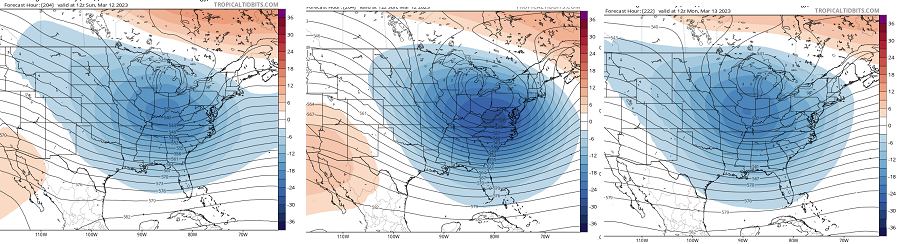
man... That 0z "control" version of the Euro was fun... It actually splits this signal into two events. Both having sfc pressure down below 980mb... The first of the two, Mar11/12th... then, just 3 days later, it brings another up. Of the two, the first one goes up the Hudson.. snow for interior PA to SE NY, W MA and the Greens, but we all probably start as wet snow before going to rain east - so less than idea. But that 2nd one... wow, quite the eye-candy. It's got temperatures 15 to 25 everywhere NW of Taunton ... with a 974 mb low passing from just S of LI to the BM. Total 24-hour QPF is averaging 1.8" melted SE of PSM NH to HFD CT line, with over an inch NW, and 3" on the Cape where it's like 34F and probably sustaining close to hurricane wind gusts... We have mentioned that this period of time between the 10th and 15th may host multiple events... it's certainly plausible that carries us right up to the equinox ( spring challenges increasing/notwithstanding). The 2nd one above is 17th or so.. So unfortunately, there is almost no deterministic value at this range.
-
None of them were! ...except the one model, and it's ensemble mean is just about 180 degrees out of phase with it. wtf - No.. as usual, this was some sort of "venting" therapy phenomenon that happens... There's a handful of repeat offenders and we all know who they are... but they have some sort of maladjusted psycho-babble bs agenda, if not quite literally competency issues, and they come into these social media outlets like they're their own sandbox.
-
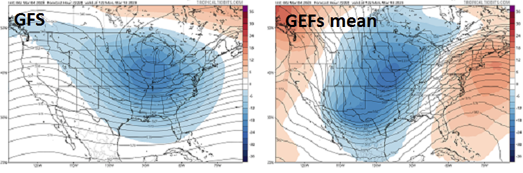
Thanks Will - Okay, so.. for those disenchanted by the GFS, I can assure you it is a vast ...literally diametric peregrination, comparing across all guidance modes and means, including it's own ensemble consensus. This first step, easy, quick ...available to all ( for f-sake) comparison, demonstrates that the operational version is radically off on it's own... ...sorry that ended up blurry...but those are the 06z 200+ ( within 12 hours of one another) .. Anyway, more over, the EPS, the GEPs, both demo coherent signals of a Nor'easter type coastal projection. Particularly in the EPS Fwiw, the operational Euro, and the operational GGEM ... are in much better sync with the overwhelming suggestion that is also agreed upon by all three EPS/GEFS/GEPs considered... So that covers the case presentation by the Defendants - ... In closing remarks, I'd also push the hypothesis that the operational GFS, may be in troubled waters considering it's native bias. It tends to progressively stretch the flow, which is noted in be error logs at NCEP...etc... It's subtle, but real, and measurable. That said, it seems that ( take the lead up to today's event - ) when the flow is fast ( gradient rich), the GFS may perform better, because the flow its self is concerted to the GFS tendency. But in this case above, there is a pretty profound change in the hemisphere going on. The flow is attempting to hang blocking over 60 to 70 N across the Canadian shield. This lowers heights along 35 N... so the flow relaxes the gradient some, and that slows the flow. That may not jive so well with the GFS. I'm suspicious of the GFS in a pattern that is differentiating into a slower/blockier affairs.
-
It's alright ... For those interested in actual substantive analysis ( or are even capable of cogency in that regard ..which frankly ) This signal is still precisely where it was in terms of robustness when this thread started. Before demoing why... many may want to re-read the opening missive?
-
I've asked Will to clean up the last 2 or so pages of this thread, which was started in good virtue and intent.
-
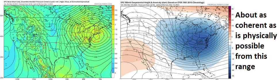
EPS's 00z mean was definitively SE of the 12z mean early yesterday -
-
Don't attempt to block this therapeutic commiseration orgy with anything that 'pulls out' a decent look...
-
This isn't gonna cut it, frankly. It's March 4 in the day. These fall rates presently will sustain one's stack but their not gaining and the drip fest will commence soon ...straight through the overcast. ..glop bombs slipping from the trees and birds zipping to and fro' in disrespect ... It smells like rain while the aggregates struggle to remain actually aggregates... Get the picture? lol - This is a classic spring snow event. Whether it really looked that way in guidance or anyone happened to mention ( all salutations conferred), this is a blue bonk. Relatively minor one in my town. I'm a 4.5" ... C+ performance. But a colder temp might have given this closer to a half foot. That's my morning "hot" take
-
Holy shit! 18z NAM FOUS over Logan 18073978031 10117 980936 45009799 .73" in 0C, -3C, -1C at 980, 900 and 800 mb levels respectively. 36kt sustained!! 24054977913 -8321 940438 41009796 .54" in 0C, -3C, -4C at 980, 900 and 800 mb levels respectively. 38kt sustained!! The open tarmacs if that goes over to pure snow would get close to verifying. I haven't seen the synoptic charts just yet. This may be confined to just the coast...but those numbers there illustrate an upper moderate/low end major event.
-
this run's garbage now that I look it more fully...


