Typhoon Tip
-
Posts
44,236 -
Joined
-
Last visited
Content Type
Profiles
Blogs
Forums
American Weather
Media Demo
Store
Gallery
Everything posted by Typhoon Tip
-
The last hurrah? Putting all the eggs in the Tuesday 3/14 basket
Typhoon Tip replied to Ginx snewx's topic in New England
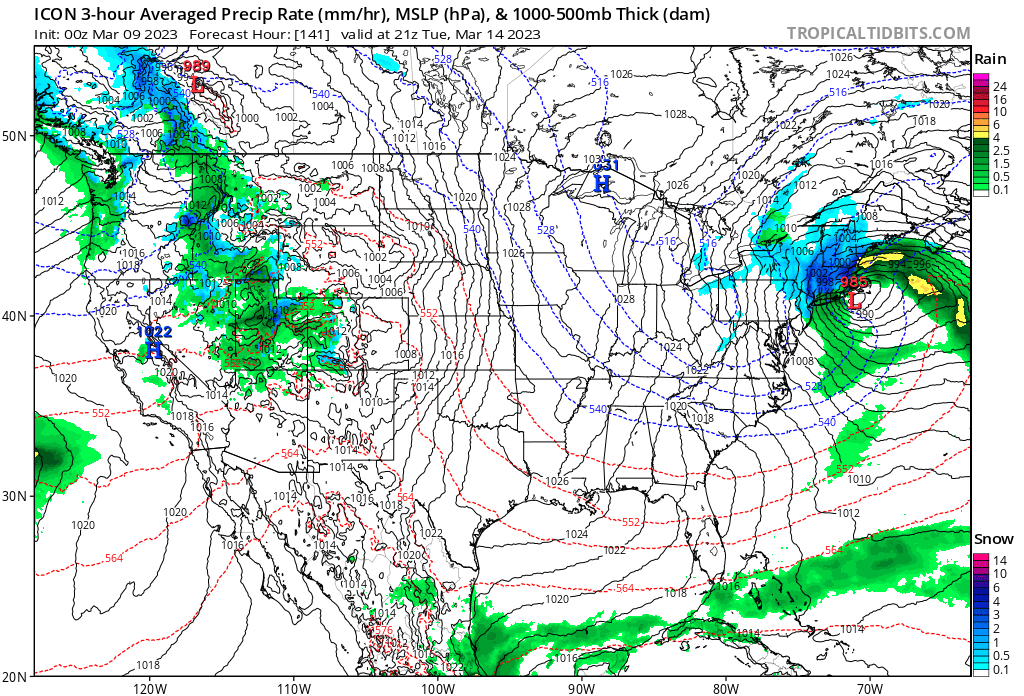
Going back many cycles in mind's eye... I don't recall if there was ever one where no model offered d-drip doses. There's always one that's not allowing us to drift away from this .. pure evil man. lol The UKMET has 30" then fades, but look out! Here comes the ICON ...or the Euro ... There really is just about zippo operational version consensus. Only that there's a system passing through -
Nothing campaigns spring like 504 dm hydrostats down to Pittsburgh PA on March 25th... not sure, though, how much of this is just the GFS non-responsive to the seasonal forcing - I've sort of sensed this since the era of rapid version upgrades ...going back about 5 or 7 years. I realize that's 384 hours so has 0 real value, but I'll be watching for the GFS' incompetence to sense the hemispheric changes and fighting it. Obfuscating matters ... I suspect that a general colder and stormier profile to the pattern may persist though to the 20th anyway.
-
I realize this is back-burner for most at this point... but, just dropping by to update: The end point of this risk period, the 15th" ... has definitely become more negotiable ... The hemisphere may persist in this kind of phase proneness. But at an even baser level, steady diet of Pacific waves with tendencies to +PNAP, while modest less than overly suppressive blocking across 60-70N points to a longer finish. There's another increment therein possible between the 18th and the Equinox. This system next week may not be the last event as some have tongue in cheek surmised - ... personally wish it was but it is what it is
-
The last hurrah? Putting all the eggs in the Tuesday 3/14 basket
Typhoon Tip replied to Ginx snewx's topic in New England
Euro construct 3 to 4mb > sfc PP across Quebec -
The last hurrah? Putting all the eggs in the Tuesday 3/14 basket
Typhoon Tip replied to Ginx snewx's topic in New England
yeah...convention ( and for good reason) at this range is to lean on ensemble means - interesting -
The last hurrah? Putting all the eggs in the Tuesday 3/14 basket
Typhoon Tip replied to Ginx snewx's topic in New England
Sooo.. heh 12z's have either trended warmer, or a big waste of time ... take a pick? sounds like March D6 forecasting, incarnate. -
The last hurrah? Putting all the eggs in the Tuesday 3/14 basket
Typhoon Tip replied to Ginx snewx's topic in New England
GFS is just progressive compared to all other guidance... It's tearing apart the phase manifold by forcing everything to England -
The last hurrah? Putting all the eggs in the Tuesday 3/14 basket
Typhoon Tip replied to Ginx snewx's topic in New England
It was non-existent haha... Yeah...I mean I'm not sure but that particular event has been continuously popping up in my mind, not because it is any kind of an analog or even close to it... but just in so far as that thermal aspect - that mostly fell at night. That's A... it raged on into the morning but by then the CCB was so dense that even with April sun rising over it was unable to overcome the "cold momentum" if you will... I'm also not abundantly sure there wasn't any deceptively albeit crucially important llv cold lurking across Nw-N NE ... Sometimes like Will and I were mentioning it only takes a couple DP worth in a marginal set-up to make world's of difference. -
The last hurrah? Putting all the eggs in the Tuesday 3/14 basket
Typhoon Tip replied to Ginx snewx's topic in New England
ICON is several dm deeper in max amplitude/stall point near the latitude of PSM/E ... which is too far up our keesters for comfort. Not sure on the model at any point beyond 36 or so hours... I've seen it be vagarious at just the precisely wrong amounts ...however unnoticeable ... kinda like it was trying to get away with something haha...you believe it... risking at own peril. Anyway, relative to this run, this appears to be a deeper mid level amplitude management, while still not detecting enough cold air to have helped force this thing more S/SE of that end 144 hour position. -
The last hurrah? Putting all the eggs in the Tuesday 3/14 basket
Typhoon Tip replied to Ginx snewx's topic in New England
right ...the N and S ends of 495 are quite a bit closer to the coast than the W-NW arc of that civil layout. it's kind of why the distinction of 'beyond 495' sort of tacitly really means NW of the tangent to that arc ... like this I guess ...But is obviously negotiable at the southern end of that bold line... and also it's not a hard transition axis either - there's fiddle room depending on circumstances..
-
The last hurrah? Putting all the eggs in the Tuesday 3/14 basket
Typhoon Tip replied to Ginx snewx's topic in New England
Ha... no idea that conversation happened.. (little too much traffic in here to keep track I guess -) Right, in addition to forcing low position ...it then focus those other goodies aloft too. I was being more broadly conceptual but yup -
The last hurrah? Putting all the eggs in the Tuesday 3/14 basket
Typhoon Tip replied to Ginx snewx's topic in New England
My bigger take away from these overnight various products ... in whole, we lack antecedent cold. Long version of what/why that tenderizes butts ... Determining this thing's ultimate position in space would be better performed if the baroclinic gradient was not so week. You need that dense, cold medium abutted to a waif warm humid air mass. Example, the 'roids version of that is Dec 2005. The thermal packing between NJ and Cape Cod was extraordinary. In this case? not extraordinary. In fact, less than even ordinary. It's the same thickness and synoptic parameters over BTV as it is over ACK upon the arrival of the mid level forcing(s). The low in the model vision has no axis along which is compelled to position. These aspect feed back on one another. With a better defined baroclinic axis, that focuses a vortex centric UVM (upward vertical motion) in the lower altitude of the vortex medium, which causes height falls over that region, and then the phasing aloft that is concurrently happening snaps into place/collocates and whole thing goes synergistic ...and annuls are written. But here, we have enough mid levels for history but that lacking of those crucial aspects beneath... the low is just physically not limited in hooking W ( Euro). It's probably something like the 1888, not as a total analog ( no ), but that it may be over top warm intrusion. There is time to correct the antecedence colder... Sometimes in these mid range spring systems, they will look this way in the mid ...ext ranges, with warm air wrapping around the top and the cold underneath, but then as the whole show gets closer in time ... sensitivity seems better and the model physics "detect" more BL (boundary layer) resistance ... It's tough, because these guidance' don't put out solutions that are impossible - that's not how this works. No model is a model if they do that - they are the peregrinations of George01's imagination behind a torpid gaze out the window if they do... -
The last hurrah? Putting all the eggs in the Tuesday 3/14 basket
Typhoon Tip replied to Ginx snewx's topic in New England
It does sort of give me pause, though that these models are not cutting through the morass yet… Most “big dogs“ in history tend to show up early … showing some continuity. It’s like we kind of do and don’t thought it’s weird. -
The last hurrah? Putting all the eggs in the Tuesday 3/14 basket
Typhoon Tip replied to Ginx snewx's topic in New England
I would be shocked if much more than a third … maybe 1/2 …of that happened given that solution the GFS. Goofball runs so far dunnite -
The last hurrah? Putting all the eggs in the Tuesday 3/14 basket
Typhoon Tip replied to Ginx snewx's topic in New England
… still manages an upper moderate event for eastern north eastern mass southeast New Hampshire -
The last hurrah? Putting all the eggs in the Tuesday 3/14 basket
Typhoon Tip replied to Ginx snewx's topic in New England
It’s acting like it wants to just miss phasing… But again the GFS with that slight progressive bias in the mid range it doesn’t shock me. This thing seems like it’s really sensitive. -
The last hurrah? Putting all the eggs in the Tuesday 3/14 basket
Typhoon Tip replied to Ginx snewx's topic in New England
Frankly… I’m not sure I trust them if they were modeling yesterday at this point. -
March 10-11 light snow threat for SW New England.
Typhoon Tip replied to Sey-Mour Snow's topic in New England
Yeah it’s decent… It closes off that 500 mb surface there … implies bit of in situ frontogenic forcing. Even hints IVT convergence NYC does well … even though it has tosnow at 12 in./hr to stick anywhere downtown at this time of year in that thermal cauldron of a city -
The last hurrah? Putting all the eggs in the Tuesday 3/14 basket
Typhoon Tip replied to Ginx snewx's topic in New England
I mean to elaborate a little what Scott just said… It’s like the northern stream behave like it should “IF” the southern Stream was there, which is odd because the southern stream is missing …. so the whole run looks weird. -
The last hurrah? Putting all the eggs in the Tuesday 3/14 basket
Typhoon Tip replied to Ginx snewx's topic in New England
You beat me to it ha ha -
The last hurrah? Putting all the eggs in the Tuesday 3/14 basket
Typhoon Tip replied to Ginx snewx's topic in New England
Yeah, that whole evolution of suspicious to me -
The last hurrah? Putting all the eggs in the Tuesday 3/14 basket
Typhoon Tip replied to Ginx snewx's topic in New England
Yeah, the solution is a little suspicious. -
The last hurrah? Putting all the eggs in the Tuesday 3/14 basket
Typhoon Tip replied to Ginx snewx's topic in New England
Still quasi-bombs, though
-
The last hurrah? Putting all the eggs in the Tuesday 3/14 basket
Typhoon Tip replied to Ginx snewx's topic in New England
And rainy lol -
The last hurrah? Putting all the eggs in the Tuesday 3/14 basket
Typhoon Tip replied to Ginx snewx's topic in New England
Jeez y’all come off as mordant while thinking you don’t really sound that way