Typhoon Tip
Meteorologist-
Posts
43,840 -
Joined
-
Last visited
Content Type
Profiles
Blogs
Forums
American Weather
Media Demo
Store
Gallery
Everything posted by Typhoon Tip
-
hooo... (exhaling) we can relax. The JMA saves the d-drip dosing
-
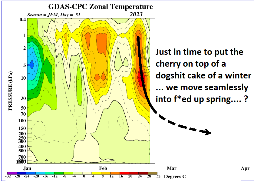
..heh... 'cool' ? what I just described transcends a 'cool spring' ...and that's what we may end up with, a sort of protracted May 2005 deal. Not all SSW --> -AO effect our hemisphere the same...some may not show up, some do really bad like in 2005 ... But, we're talking physically raining in cold air... never stopping, not just cool. If that's what is really coveted, okay - but just so's we're clear
-
I don't really care if it snows or not in that sense. I'm interested if snow is falling...or may do so, Sure. But it doesn't hit me that hard if it doesn't work out - especially post Feb 15 any year. I like intersting events for a spectrum of the weather output. I think it's cool when you get IP aggregation... several of them frozen together... they're loud and bounce and shatter... Neat to see.
-
I realize y'all in that Pike latitude really are straining and I'm sensitive to that ...but this looks like from Ray's area to myself/FIT gets a solid 5 hours of straight moderate 1/2 to 1/3 mi vis snow before we IP on that run. That's actually more than I anticipated at this threads inception along Rt 2. ...But, no one can be held accountable in the CH scenarios... the gradient is so finite that it's beneath the resolution of the best tech and minds... imho. ha.
-
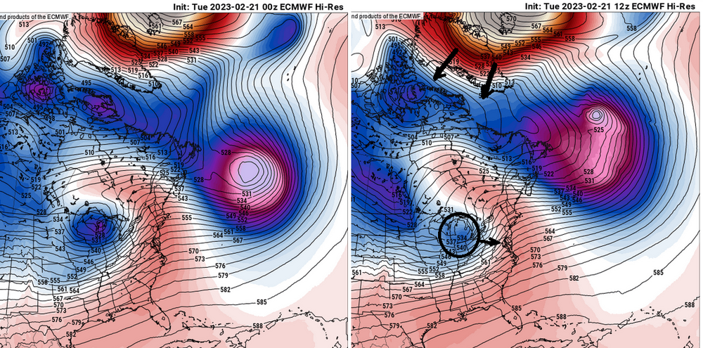
y'allz funny mu'fuggers Actually, this 12z run of the Euro ...I'm telling you, you can see more NAO exertion comparing 156 to the previous 168 ... f ...here that's why this run is better. It's subtle, but you can see how the 12z retros the NAO just a little over the previous cycle ( left ) and immediately ...the hemisphere responds by forcing the Lakes cutter more E. It just takes that little bit of adjusting and it forces the activity here, South. which ( now to confuse you ...) isn't really the NAO forcing it - it gives that allusion. It's really just that these features move as an integral at large scales, or tend to.
-
seldom do I engage in this sort of discussion but .... really? Serious Q: do you like 40 F mist in between 38 F straight rain nor'easters... always relentlessly every day ?
-
I like the appeal outside today though ...least around here. We got the old 'under the radar' grits and flurries going... it's a solid fireplace afternoon. Also, that looks somewhat convective out there in NYS ...wonder if we can't get a burst later this evening
-
-
well they'd better hurry ... Running out of time before they have to just be flat out considered busts... I don't accept in recent tech advancing in these tools ... a day's lead than 'oh, by the way'? UN acceptable. That is a failure That said... were/if folks were 'hoping' cold corrections would continue right on into a snowier solution for us, down here, ...yeah, not impossible. But it was never really on the better side of the odds with this mess. It's still really unchanged to be blunt. Looks like RUT -PWM ~ latitude for snow to me, with IP --> ZR --> cold rain however far it takes to ruin yet another opportunity in this winter of misfits going S.
-
So... I'd definitely pump the breaks in vesting in the 28th/1st and anything afterward - if that hasn't already happened. Models are renegotiating the timing of the NAO, a facet I brought up yesterday as a 'delay' in the onset - certainly the ability of any would-be -NAO to exert over the western limb of the domain. That was a transition new motif as of yesterday, and I noticed immediately ... systems were accelerating in the cinema of the models for the period beyond this 23rd scenario. That change in the circulation exertion has become even more coherent ( unfortunately for the 28th...) overnight. All three, EPS/GEFS/GEPs really don't have enough to suggest the 28th will take either a more S friendly track, or slow enough to get its act together before leaving, any longer. As a result, the GEPs resolves this by taking a primary too far up the ST L region before committing to a Miller B reposition in the GOM. Deep too! At 180+ hours, it's down to 982 as a mean, which is about as deep as can be for a typically noisy multi-member average. But that's too late, and the front side ...not sure a SWFE can result from that thermal layout. The EPS is similar actually...only not as deep. But it doesn't matter - there's a real entity in the flow that will also behave like that, too high for even Central NE before Miller B transition, and to too late to vest in - save perhaps moose-fart NE Maine. GFS ...similar again, but not as deep as the EPS... Same essentially, a doesn't matter scenario as the entity it's managing along ends up too far NW with the primary before it the secondary gets going = too late. All of these solution are responding to the back-off of the western exertion/NAO model, one that was a bit more aggressive/present in the runs prior to yesterday. The solutions they do have, and this is evident particularly in the operational GFS' 06z run... appear cold challenged now, too. That's because said circulation control is no longer there - or removing. Without it, we're losing the mechanism to load crucial cold thickness between successive events. Yeah... all and all I'd say this was a butt boning series overnight ...and another in a long and tiresome examples of why the NAO cannot be relied upon and is also overrated. Aside from the fact, the NAO is actually an illusion in a philosophical way...because its modes are really controlled by way of the non-linear wave function from the flow coming across the Pacific and N/A... so when we look for an NAO, it's really more of a beacon for if the Pacific non-linear wave function is transmitting a signal.. blah blah blah Anyway, long history of NAO bamboozling so not just for the 28th/1st ...I'd also keep all this shirking by the model in mind as we attempt to peer into a March that frankly, I wouldn't be surprised if it hosted a 80F warm burst like DC... In a lot of ways, this current 23rd ordeal and the PV advent ...compressing the field enough to cause it, is really merely interfering with our 2018 redux. And I don't have any faith at all, one can't succeed next month when the sun really is getting cooking and the NAO ( or Pacific...which ever one needs to use ), continues bring winter enthusiasts back from dead, only to send them through this tortured hell of 'it can still happen' LOL
-
Especially because there’s a relative min band right there at Ray’s
-
Exactly...and when half the block is actually eclipsing the British Isles aspect of the NW European continent ...how east does it have to be before we can just call it a block and leave it at that... It does start rero motion but not until this month is gone -
-
And what bizarre looking system late on the 26th thru early 27th ... It's cinema has an ANA backside with a deep low out in front. Something tells me future guidance will be morphing that into something that actually typically happens on Earth.
-
Yeah... the -NAO is delaying the last several runs...That's why that GFS is doing that. Prior to about 18z yesterday, the NAO blocking was faster to retrograde, and it was timed so that the 28th would be forced to slow down a bit. Now, ...it's more like Mar 2 .. 5, and that leaves these leading systems to careen east in the otherwise compressed/gradient saturated heights.
-
Considering the variations over the last 24 hours of run cycles...the whole period strikes me as though the physical processes "detect" the underlying index scaled ginormous potential, but the smaller scaled movements over top are doing so, so fast the model can't use one to really exhaust that volatility. It seems like every virga shrouded CU the model tries to run through the 80 to 60W window the model tries to turn it into a 965 mb low going S of NS.
-
It's on my mind.. didn't want to troll the mood - haha... But I did see a graphic a couple days ago that Boston ( assuming really Logan -) was running 3rd place in all-time warmest winters. Also the assumption, that must mean DJF averages. The 2nd place, 2015-2016 was a single decimal point warmer... may be in jeopardy of ceding the tie. I dunno - Also wondering what's the deal with the other climo sites in the region.
-
Fwiw re the 28th- Euro is farther N before cutting over to a Miller B. The solution looks odd though. Not sure that's likely... The GEPs, wow what a correction by that ensemble system. Went from a broad ..vague cyclonic curvature with a spattering of members to variable depths, all the way down to 994 mb inside of several closed contours just E of the Cape -198 hrs. It's got several members below 970 mb around Logan... jesus. That's about as loud a signal as is physically possible from this range. The GEFs is about where it's been the last several cycles, though it's been ticking NW overall by small movements. It's more 1000 ...998-ish. Decent.. Haven't seen the 12z EPS but the 00z EPS mean argues the operational is a significant NW outlier overall. It has a classic Miller B transition to S of LI, and it too is 994-ish at D8/9 ...That's also just about as coherent as is ever going to be seen at this range. Just for shits and giggles...it's got one member that's 952 mb about 30 mi W of ACK! actually ...I miss read that. 982 ... maybe 962. anyway It'll be interesting to see what it looks like as 12z
-
So it's sets at 61 in light wind and ample sun... It's a nape factor of 9.5 out there... 60 today, wet snow tomorrow ? Tell me it isn't spring already ... I guess when it's 23 F at 6 pm on Thursday by a raging tucker, that ought send the locals reeling
-
I don't think it's even the weather ... It's the cinema in the guidance before hand ...and the excitement impulse of that aspect, specifically... It's quite likely related to an addictive response - that's what it seems to me. But, that said ... so what? it's not up to anyone to attempt to correct that behavior.
-
Ha ha ... thought did cross my mind. Plan on doing 5 mi run outside for a change... But, wake up and it's cloudy tomorrow morning with some wet aggies starting to fall and I'm sure I'll swap out my mood pretty fast.


